

Mori Atlas logo
Nature reserveYathong Nature Reserve

Examining the semi-arid mallee woodlands, rugged ridges, and extensive conservation terrain of inland Australia.

Yathong Nature Reserve: A Vast Protected Landscape and UNESCO Biosphere in New South Wales

Yathong Nature Reserve serves as the largest nature reserve in New South Wales, protecting a critical mosaic of semi-arid mallee eucalypt shrublands and woodland communities. As an anchor of the Central NSW Mallee Important Bird Area, this extensive conservation landscape offers a deep look into the biodiversity of the Cobar Peneplain and Murray Darling Depression. The reserve functions as an essential refuge for rare flora and specialized ground-dwelling fauna, preserving ecological integrity within its protected boundaries.

mallee shrublandssemi-arid woodlandsbiosphere reserveimportant bird areanature reservebiodiversity refuge

Yathong Nature Reserve

Nature reserve

Park overview

Structured park overview, official facts, and landscape profile for Yathong Nature Reserve

Yathong Nature Reserve park facts, protected area profile, and essential visitor context

Review the core facts for Yathong Nature Reserve, including designation, size, terrain, visitor scale, habitats, and operating context in one park-focused overview.

About Yathong Nature Reserve

Yathong Nature Reserve is one of the most significant semi-arid conservation landscapes in eastern Australia. Located deep in the central-western interior of New South Wales, it represents a large, contiguous block of mallee and woodland habitat that has been heavily modified elsewhere across the region. The reserve's size and its position across two major bioregions, the Cobar Peneplain and the Murray Darling Depression, give it a landscape diversity that underpins its biological richness.

The terrain is shaped by flat to undulating plains, low ridges, and the prominent Merrimerriwa Range, which runs through the south-eastern portion of the reserve. Soils vary from thin sandy and stony profiles on the ridges to deeper colluvial and texture-contrast red earths across the broader plains. Above this varied substrate, semi-arid climatic conditions produce hot, dry summers, mild winters, and relatively steady rainfall, creating the environmental framework in which Yathong's distinctive plant communities thrive.

Yathong is more than a refuge for plants and animals; it is also an important cultural landscape. The Ngiyam and Wiradjuri peoples are recognized as the traditional owners of the land, and their knowledge, heritage values, and sites are integrated into the reserve's management approach. Combined with its UNESCO Biosphere Reserve status and its role within the Important Bird Area network, this cultural dimension reinforces Yathong's standing as a landscape of both ecological and human significance.

Within New South Wales, the reserve is regarded as a benchmark for understanding semi-arid biodiversity patterns and for managing the long-term pressures of fire, feral animals, and invasive plants in a way that balances ecological health, cultural heritage, and public interest.

Quick facts and research context for Yathong Nature Reserve

Yathong Nature Reserve lies in central-western New South Wales, roughly 130 kilometers south of Cobar and more than 650 kilometers west of Sydney. It is the largest nature reserve in New South Wales and is classified under IUCN Category Ia as a strict nature reserve. The area is jointly recognized as a UNESCO Biosphere Reserve, having been listed under the Man and the Biosphere Programme in 1977, seven years after the reserve itself was established.

The reserve covers around 107,000 hectares of semi-arid landscape, spanning the Cobar Peneplain and Murray Darling Depression bioregions. It is a core component of the Central NSW Mallee Important Bird Area and borders the Nombinnie Nature Reserve. Governance is provided by the NSW National Parks and Wildlife Service, with active involvement of the Ngiyam and Wiradjuri traditional owners in cultural heritage management.

Protection and recognition

Documented terrestrial conservation scope and official establishment records

Yathong Nature Reserve Protection Status and Designation History

Yathong Nature Reserve maintains a documented terrestrial protection scope established in the designated year 1977. Official records outline management parameters and foundational designation history for this protected area.

Protection details

Protection scope
Terrestrial
Designated year
1977
Transboundary protection
No
Park context

Deeper park guide and search-rich context for Yathong Nature Reserve

Yathong Nature Reserve history, landscape, wildlife, and travel context

Explore Yathong Nature Reserve through its history, landscape character, ecosystems, wildlife, conservation priorities, cultural context, and seasonal travel timing in a structured park guide built for atlas discovery and search intent.

Why Yathong Nature Reserve stands out

Yathong is best known for its extensive, relatively intact mallee vegetation communities, a habitat type that has become rare across southern Australia. Roughly half of the reserve is covered by mallee eucalypt shrublands, including green mallee, grey mallee, white mallee, red mallee, yorrell, and Dwyer's mallee, which together support a specialist suite of birds, mammals, and reptiles. The reserve is also recognized as a stronghold for the malleefowl, a ground-dwelling bird whose dependence on mature mallee habitat has made it a focus of national conservation effort. Its inclusion in the Central NSW Mallee Important Bird Area and its UNESCO Biosphere Reserve status reinforce Yathong's role as a benchmark site for semi-arid biodiversity conservation in eastern Australia.
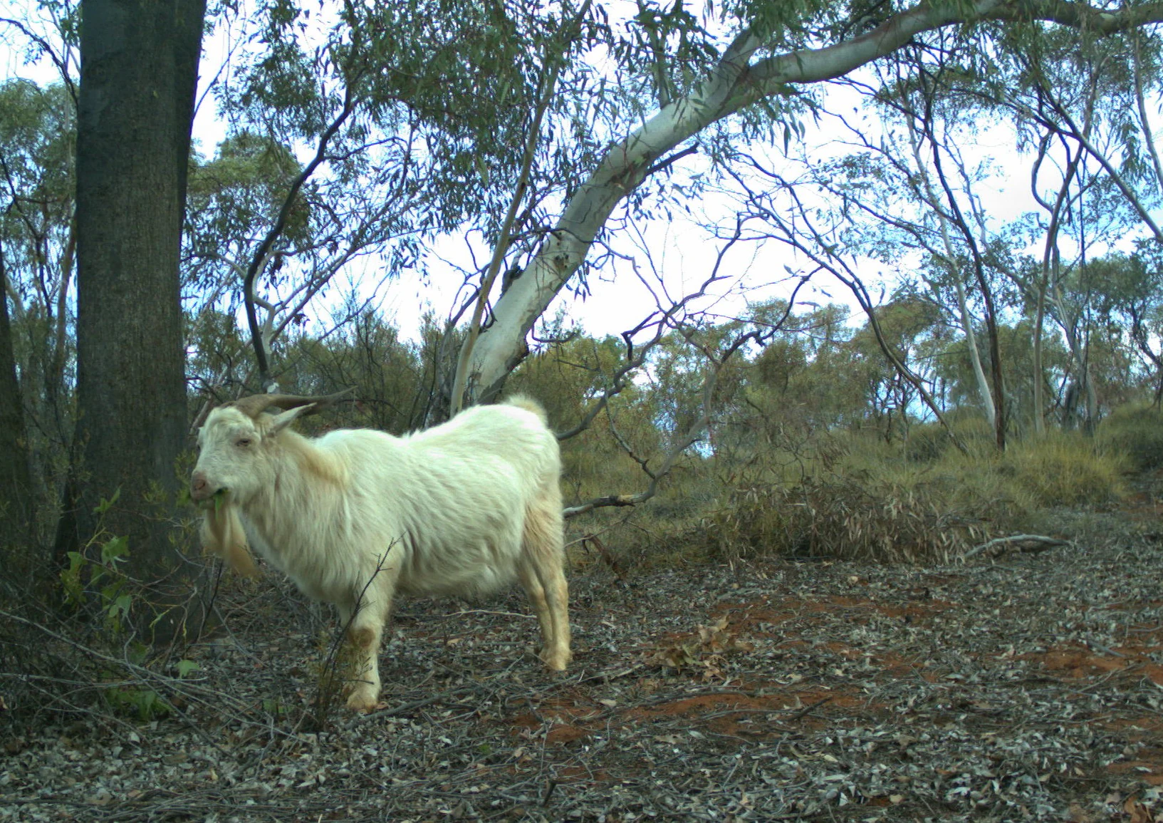
A white goat with long horns standing in a sparse, dry woodland with eucalyptus trees and leaf litter on the ground.
A feral goat captured by a remote camera in the semi-arid bushland of Yathong Nature Reserve.

Yathong Nature Reserve history and protected-area timeline

Yathong Nature Reserve was formally established as a nature reserve in April 1971, marking its recognition as a landscape worthy of long-term protection. Its ecological and cultural significance quickly drew broader attention, and in 1977 it was inscribed as a UNESCO Biosphere Reserve under the Man and the Biosphere Programme. This dual designation as both a state-level nature reserve and an international biosphere reflected the unusual concentration of biodiversity and intact habitat found on the property.

The Foundation for National Parks and Wildlife was involved in the early establishment of the reserve and subsequent conservation campaigns, particularly those focused on the malleefowl. Over time, the management approach has expanded from a narrow focus on flora and fauna protection to a broader framework that incorporates cultural heritage, traditional owner engagement, and fire management. The reserve has also entered the Important Bird Area framework, strengthening its role in long-term monitoring and conservation planning.

Although the protected area is relatively young in formal terms, the broader landscape carries a much older history shaped by Indigenous land-use practices, followed by European-era pastoral activity. Historic grazing has left lasting impressions on vegetation structure and distribution, and the reserve's management plan acknowledges the need to understand, and where possible remediate, these historical impacts while continuing to support biodiversity recovery.

Yathong Nature Reserve landscape and geographic character

The landscape of Yathong Nature Reserve is defined by the semi-arid character of central-western New South Wales. Broad, flat to gently undulating plains dominate much of the area, interrupted by scattered ridges and low ranges. The most prominent of these is the Merrimerriwa Range, which extends through the south-eastern corner of the reserve and provides some of the most rugged and elevated terrain in the property.

Soils across the reserve reflect this topographic diversity. Ridges tend to carry thin, sandy or stony soils with limited moisture-holding capacity, while broader plains and valleys support thicker colluvial deposits and red earths that show clear texture-contrast profiles. These soil patterns strongly influence which vegetation types can establish and persist, contributing to the patchwork of mallee, grassy woodland, and semi-arid woodland communities observed across the reserve.

Climatically, the reserve sits within a hot, dry, semi-arid zone, experiencing hot summers and mild winters, with rainfall distributed relatively evenly through the year. This climate, combined with the underlying geology and soils, gives Yathong its characteristic mix of open mallee shrublands interspersed with woodland patches, an environment that feels both expansive and subtly varied across long distances.

Yathong Nature Reserve ecosystems, habitats, and plant life

Yathong Nature Reserve is shaped ecologically by the meeting of sub-tropical, arid, and semi-arid influences across its two bioregions. This blend of climatic and geographic gradients gives rise to a mosaic of habitats, from dense mallee stands to more open grassy and semi-arid woodlands. The result is an unusually rich plant community for a semi-arid system, with around 460 species recorded, 12 of which hold some form of protected status in New South Wales, including the vulnerable curly-bark wattle and the extinct-listed wingless fissure-weed.

Roughly half of the reserve is dominated by mallee vegetation, dominated by multi-stemmed eucalypts such as green mallee, grey mallee, white mallee, red mallee, Yorrell, and Dwyer's mallee. These communities form a distinctive vegetation assemblage that has been substantially reduced elsewhere through land clearance and grazing, making Yathong's remaining intact mallee an important conservation focus. The remainder of the vegetation consists of woodland types, both grassy and semi-arid, featuring white cypress pine, bimble box, black box, and belah.

Historical grazing and land clearance have measurably altered community structure and diversity across the reserve, and the full pre-European character of vegetation distribution remains only partly understood. Despite these changes, the intact scale of the mallee and woodland mosaic at Yathong provides a critical reference point for studying semi-arid ecosystems and for guiding rehabilitation efforts across the broader region.

Yathong Nature Reserve wildlife and species highlights

The wildlife of Yathong Nature Reserve reflects the productivity of its semi-arid habitats, with 253 animal species recorded, all of which have protected status in New South Wales. Mammals are well represented, including the short-beaked echidna, the brush-tailed rock-wallaby, the yellow-bellied sheathtail-bat, and three nationally significant kangaroo species: the eastern grey, western grey, and red kangaroo. Reptiles are similarly diverse, with species such as the marble-faced delma, the western blue-tongued lizard, and the mallee military dragon occurring throughout the property.

The reserve is particularly important for its birdlife. A total of 162 bird species have been recorded, with concentration around the mallee habitat, which supports a distinctive suite of ground-dwelling and shrub-dependent species. Iconic and conservation-significant species include the malleefowl, the red-lored whistler, the grey falcon, the pink cockatoo (Major Mitchell's cockatoo), and the striated grasswren. The malleefowl has received particular conservation attention because of its specialized habitat requirements and its vulnerability to predation and habitat change.

Introduced species have become a major influence on wildlife dynamics within the reserve. European red foxes, feral cats, feral dogs, feral pigs, goats, and rabbits are the most prominent, with predation by foxes and cats posing serious risks to ground-nesting birds such as the malleefowl, red-lored whistler, and striated grasswren. At the same time, over-abundant native kangaroo populations contribute to grazing pressure, complicating management for sensitive habitat specialists.

Yathong Nature Reserve conservation status and protection priorities

Yathong Nature Reserve carries exceptional conservation significance at multiple scales. At the international level, it is recognized as a UNESCO Biosphere Reserve under the Man and the Biosphere Programme, while at the national and state scales it forms a core component of the Central NSW Mallee Important Bird Area and is protected under IUCN Category Ia as a strict nature reserve managed by the NSW National Parks and Wildlife Service. The reserve's size and the relative intactness of its mallee communities give it an outsized role in conserving semi-arid biodiversity.

A central conservation priority is the management of fire, which is recognized as a Key Threatening Process in New South Wales because of its potential to alter vegetation structure and composition. The reserve's fire management plan balances biodiversity protection with cultural heritage considerations, and the size and age structure of the vegetation provide a degree of natural resilience to drought and fire.

Equally important is the ongoing challenge of introduced species. Feral predators such as foxes, cats, and dogs directly threaten ground-dwelling birds and small mammals, while goats, rabbits, and overabundant kangaroos exert grazing pressure that can degrade habitat. Invasive plants, including lantana, bitou bush, and various perennial grasses, add a further layer of competition for native flora. The reserve also serves as a refuge for fragile species such as the vulnerable curly-bark wattle, and conservation programs implemented by NPWS and partners like the Foundation for National Parks and Wildlife continue to target these threats through monitoring, control programs, and species-specific recovery actions.

Yathong Nature Reserve cultural meaning and human context

Yathong Nature Reserve sits within a landscape of deep and ongoing cultural significance. The Ngiyam and Wiradjuri peoples are recognized as the traditional owners of the land, and their connections to country are integrated into the current management framework. Traditional ecological knowledge held by these communities informs planning around cultural heritage sites and values, ensuring that management of fire, flora, and fauna takes cultural considerations into account alongside ecological ones.

Beyond Indigenous heritage, the reserve also carries the legacy of European pastoral activity. Historic grazing has left a visible imprint on vegetation patterns, with measurable changes in community structure and distribution. Acknowledging this layered history, current management seeks to balance biodiversity recovery, cultural heritage protection, and public engagement in ways that respect both the long Indigenous tenure of the land and the more recent transformations wrought by land-use change.

Top sights and standout views in Yathong Nature Reserve

Yathong Nature Reserve stands out for the sheer scale and relative intactness of its semi-arid mallee vegetation, a habitat type that has been heavily reduced elsewhere in south-eastern Australia. Roughly half of the reserve is covered by multi-stemmed mallee eucalypts such as green mallee, grey mallee, white mallee, red mallee, Yorrell, and Dwyer's mallee, supporting a specialist community of birds, mammals, and reptiles.

Its dual recognition as a UNESCO Biosphere Reserve and as the largest nature reserve in New South Wales gives Yathong a distinctive conservation profile, reinforced by its place within the Central NSW Mallee Important Bird Area. The reserve is also a stronghold for the malleefowl, a ground-dwelling bird of national conservation concern, and a refuge for vulnerable flora such as curly-bark wattle. Combined with its cultural significance to the Ngiyam and Wiradjuri peoples, Yathong is both an ecological reference site and a cultural landscape of considerable depth.

Best time to visit Yathong Nature Reserve

Yathong's semi-arid climate shapes its year-round character rather than producing a sharp seasonal divide. Summers are typically hot and dry, while winters are mild, with rainfall distributed fairly evenly through the year. Cooler months tend to be more comfortable for sustained outdoor activity, with milder temperatures and wildlife that is often easier to observe against sparser ground cover.

For visitors interested in birdlife, especially mallee-dependent species such as the malleefowl, red-lored whistler, and striated grasswren, the cooler and slightly wetter periods of the year can be rewarding, when birds are generally more active and conditions for extended observation are more comfortable. Wildflower displays following rainfall events can also enrich any visit, although their timing varies with local weather patterns.
Monthly climate preview

Long-term representative point measurements for temperature and precipitation

Yathong Nature Reserve Climate Normals and Annual Temperature Rhythm

Representative coordinate records reveal monthly mean temperatures ranging from 9.43 degrees Celsius to 28.23 degrees Celsius alongside consistent low daily precipitation values throughout the year. Reviewing the complete twelve-month profile provides deeper analytical insight into historical temperature extremes and precipitation distributions across the protected landscape.
Annual mean19 °C
9 °C28 °C
Jan28°
Feb27°
Mar23°
Apr18°
May14°
Jun10°
Jul
Aug11°
Sep15°
Oct19°
Nov23°
Dec26°
Warmest month
January

28.2 °C

Coolest month
July

9.4 °C

Wettest month
February

1.5 mm/day

Driest month
August

0.7 mm/day

Park location guide

Geography guide, regional context, and park location map for Yathong Nature Reserve

Yathong Nature Reserve park geography, regions, and map view in Australia

Understand where Yathong Nature Reserve sits in Australia through a broader geographic reading of the surrounding landscape, nearby location context, and its mapped position within the national park landscape.

How Yathong Nature Reserve fits into Australia

Australia is a constitutional monarchy and federal parliamentary democracy comprising six states and ten territories. With a population of nearly 28 million, it is one of the world's most urbanised countries, with most people concentrated on the eastern seaboard. The country has a high Human Development Index and is known for its cultural diversity, ancient Aboriginal heritage, and unique wildlife.

Wider geography shaping Yathong Nature Reserve in Australia

Australia occupies the entire Australian continent, the island of Tasmania, and numerous smaller islands. It is the world's flattest and driest inhabited continent, featuring vast deserts in the interior (the Outback), tropical rainforests along the eastern coast, and a coastline bordering the Indian and Pacific Oceans.

Map view of Yathong Nature Reserve

Use this park location map to pinpoint Yathong Nature Reserve in Australia, understand its exact geographic position, and read its mapped placement within the surrounding landscape more clearly.

Pigeon | © OpenStreetMap contributors

Location context for Yathong Nature Reserve

New South Wales

Visual reference guide to semi-arid terrain, eucalypt shrublands, and protected habitats

Yathong Nature Reserve Photos and Mallee Landscapes

Visual documentation provides a clear window into the expansive plains, scattered ranges, and intact mallee vegetation communities characteristic of the reserve. Examining these protected habitats and terrain variations reveals the distinctive environmental character that defines eastern Australia conservation landscapes.

A white goat with long horns standing in a sparse, dry woodland with eucalyptus trees and leaf litter on the ground.

Park atlas

Compare surrounding mallee shrublands and regional conservation landscapes

Explore Protected Areas and Parks Near Yathong Nature Reserve

Browsing parks near Yathong Nature Reserve reveals connected semi-arid woodlands and protected habitats across the Cobar Peneplain. Extending the geographic comparison highlights regional biodiversity patterns and adjacent conservation reserves.
National parkNew South Wales
About 79 km away#1 closest

Southwest

Willandra National Park: National Park Protected Landscape & Geographic Context

Discover mapped boundaries within this New South Wales protected area.

Willandra National Park is a designated national park in New South Wales, Australia, offering focused opportunities for understanding protected landscapes. This entry provides essential geographic context and highlights the importance of mapped park boundaries for atlas-driven exploration. Users can engage with the park's specific landscape identity and its contribution to the broader regional geography of New South Wales through structured data.

Area
193.86 km²
Established
1972
IUCN
II
Relief
Lowland
National parkAustralia
About 141 km away#2 closest

Northwest

Paroo-Darling National Park: Mapped Boundaries and Protected Landscape Geography

Explore the geographic context of this Australian national park.

Paroo-Darling National Park is a protected national park offering insights into Australia's natural geography. This section provides details on its mapped protected area, highlighting the landscape and regional context. Understand the park's geographic footprint and its importance as a conservation landscape within the Australian continent.

Area
1,780.53 km²
Established
2000
IUCN
II
Relief
Upland
A horizontal watercolor illustration depicting rolling, hazy hills covered in sparse green trees and shrubs, typical of arid woodland terrain.
Nature reserveNew South Wales
About 164 km away#3 closest

South

Pulletop Nature Reserve: Mapping the Mallee Woodlands of New South Wales

Protected semi-arid landscapes and malleefowl habitat

Pulletop Nature Reserve stands as a preserved fragment of the extensive mallee woodland that once dominated inland New South Wales. Within the Cobar Peneplain, this nature reserve offers a look at dry-country ecosystems, featuring diverse eucalypt species and habitat for the malleefowl in a flat, undisturbed geographic setting.

Area
1.45 km²
Established
1963
IUCN
Ia
Relief
Lowland
National parkRiverina
About 177 km away#4 closest

South

Cocoparra National Park: Semi-Arid Hill Country and Protected Landscape in Riverina

Explore mapped geography and key natural features of this Australian national park.

Cocoparra National Park is an essential protected natural area within Australia's Riverina region, noted for its striking semi-arid landscape. The park features a prominent range of low hills, including Bingar Mountain, rising from the predominantly flat terrain. This distinctive geography, characterized by rocky sandstone ridges and characteristic woodland communities, offers valuable insights into the region's natural heritage. As an Important Bird Area, Cocoparra National Park also holds significant conservation value for its avian populations and their unique inland habitat.

Area
83.57 km²
Established
1969
IUCN
II
Relief
Mixed relief
National parkNew South Wales
About 210 km away#5 closest

North

Gundabooka National Park: Australian Protected Landscape Geography

Mapped boundaries and regional context within New South Wales.

Gundabooka National Park serves as a vital national park entity within the Australian protected areas system. This entry focuses on its specific geographic footprint and landscape character, offering a foundation for understanding its role and distribution within New South Wales. Explore the mapped context and regional geography that define Gundabooka National Park as a protected natural landscape.

Area
639.02 km²
Established
1996
IUCN
II
Relief
Mountain
Nature reserveNew South Wales
About 218 km away#6 closest

Southeast

Charcoal Tank Nature Reserve: Mapped Protected Landscapes and Regional Geography in New South Wales

Critical mallee-broombush woodland and avian refuge in a fragmented agricultural corridor

Charcoal Tank Nature Reserve stands as a vital 86-hectare protected site in central western New South Wales, preserving rare mallee and mallee-broombush woodland that has been largely cleared elsewhere. This documentation maps the reserve's unique position within the regional agricultural matrix, detailing its significance as an long-studied avian habitat and a sanctuary for native species struggling in a fragmented, semi-arid environment.

Area
0.86 km²
Established
1966
IUCN
Ia
Relief
Lowland
National parkNew South Wales
About 233 km away#7 closest

South

Oolambeyan National Park National Park: Discover its Mapped Geography and Protected Landscape

Explore the protected area and regional context of New South Wales.

Delve into Oolambeyan National Park, a key national park within New South Wales, Australia. This entry provides essential geographic context, detailing the park's mapped boundaries and its identity as a protected landscape. It serves as a foundation for understanding the park's contribution to the regional atlas and offers a distinct perspective on the natural geography of the area.

Area
222.31 km²
Established
2001
IUCN
II
Access
Moderate access
State or regional parkNew South Wales
About 234 km away#8 closest

North

Toorale State Conservation Area: A Landmark Protected Landscape in the Western New South Wales Outback

Floodplain ecosystems and joint-managed riverine wilderness.

Toorale State Conservation Area stands as a major protected region in New South Wales, anchoring critical habitat along the Darling-Baaka River system. This vast, former pastoral landscape features extensive floodplains, arid outback terrain, and elevated lookouts that reveal the scale of the Murray-Darling Basin. As a cooperative conservation area, the land reflects both deep indigenous heritage and focused ecological restoration in a sparsely settled, semi-arid environment.

Area
543.85 km²
Established
2010
Relief
Lowland
Climate
Arid

Common questions about visiting, size, designation, and location context for Yathong Nature Reserve

Yathong Nature Reserve FAQs for park facts, access, geography, and protected area context

Find quick answers about Yathong Nature Reserve, including protected-area facts, park geography, trail and visitor context, and how the park fits into its surrounding country and regional landscape.
MoriAtlas Explorer

Continue Your Protected Areas Search Across the Global Atlas

Deepen your exploration by continuing the structured search for national parks and protected areas worldwide. Utilize the comprehensive filtering capabilities to compare different conservation landscapes and refine your understanding of global park geography. Discover more about the distribution and characteristics of protected natural areas.

Global natural geography