
Waterfalls
Park geography
Technical data on land area, mountain terrain, and regional distribution patterns
Comprehensive Geographic Profile and Mapped Boundaries of Yellowstone National Park
Analyze the precise geographic boundaries, elevation metrics, and natural features of Yellowstone National Park. This structured profile maps the terrain, spanning regions in Wyoming, Montana, and Idaho, while detailing the environmental characteristics of this extensive protected plateau.
Related tags
geothermal featuressupervolcanonational parkNorth Americabison herd
World's first national park, home to the largest concentration of geysers and a showcase of North American megafauna
Yellowstone National Park
Yellowstone National Park is a national park of the United States located in the northwestern corner of Wyoming, with small portions extending into Montana and Idaho. Established on March 1, 1872, it was the first national park in the world and remains one of the most significant protected areas on the planet. The park spans approximately 2.2 million acres, encompassing a dramatic landscape of volcanic terrain, deep canyons, alpine forests, meadows, lakes, and rivers. It sits atop the Yellowstone Caldera, the largest supervolcano on the North American continent, which has produced three massive eruptions in the past two million years. The park is renowned for its extraordinary geothermal activity, containing more than half of the world's geysers, including the famous Old Faithful. Beyond its volcanic wonders, Yellowstone serves as a vital sanctuary for wildlife, supporting the largest concentration of megafauna in the contiguous United States, including grizzly bears, wolves, bison, elk, and moose. As the centerpiece of the Greater Yellowstone Ecosystem, the park represents the largest remaining nearly intact ecosystem in the Earth's northern temperate zone.
- Location
- United States of America
- Park type
- National park
- Established
- 1872
- Area
- 8,983.2 km²
- Highest point
- 3,462 m
Location overview
Regional footprint across Wyoming, Montana, and Idaho
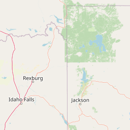
Yellowstone National Park Geographic Location and Setting
Yellowstone National Park spans the borders of Wyoming, Montana, and Idaho within the United States of America. As an entirely landlocked interior reserve, its geographic profile is defined by multiple state jurisdictions.
- Countries
- United States of America
- Regions
- Idaho, Montana, Wyoming
- Primary location
- Wyoming
- Geographic setting
- Inland
Boundary and coordinates
Mapped 8,983.18 km² extent with land record
Yellowstone National Park boundary and separate overall and land areas
Yellowstone National Park has mapped geometry and separately records 8,983.18 km² overall and 8,534.021 km² of land. The atlas preserves both figures without reconciling their difference or claiming survey authority.
- Boundary area
- 8,899.1 km²
- Boundary perimeter
- 477.5 km
- Northernmost point
- 45.109° N
- Southernmost point
- 44.1316° N
- Easternmost point
- 109.8255° W
- Westernmost point
- 111.156° W
- Geographic centre
- 44.5964° N, 110.5472° W
- North–south span
- 108.6 km
- East–west span
- 105.6 km
Elevation and terrain
Explore recorded vertical relief and named interior hydrological features
Yellowstone National Park Elevation Range and Mountain Terrain Geography
Recorded mountain relief establishes a vertical range spanning from sixteen hundred to over thirty-four hundred meters across the protected landscape. Associated hydrological features document internal streams, rivers, lakes, and ponds located entirely within the park boundaries.
- Minimum elevation
- 1,610 m
- Mean elevation
- 2,470 m
- Maximum elevation
- 3,462 m
- Highest point
- 3,462 m
Selected named natural features
Geysers
Morning Glory Pool
Waterfalls
Kepler Cascades
15 m high
Geysers
Green Spring
Geysers
Punch Bowl Spring
Geysers
Giant Geyser
Environmental setting
Alpine relief, dominant forest cover, and diverse hydrological networks
Yellowstone National Park Environmental Classifications and Physical Setting
Recorded classifications frame the physical setting through complementary habitat types, relief forms, and water presence categories. Linked records connect individual environmental attributes directly to related geographic destinations across the protected landscape.
- Relief
- Mountain
- Climate
- Alpine
- Water
- Water-dominated
- Forest cover
- Dense forest cover
- Seasonality
- Strongly seasonal
Landscape features
Mountains · Plateau · Cliffs · Canyon · Forest · Grassland · Wetland · Lakes · Rivers · Waterfalls · Volcano · Karst
Habitat types
Montane forest · Temperate coniferous forest · Temperate broadleaf forest · Grassland · Lacustrine habitat · Riverine habitat · Alpine meadow · Wetland · Karst habitat
Park atlas
Map and compare the vast protected landscapes and park geography within the greater Yellowstone region.
Explore National Parks and Protected Areas Surrounding Yellowstone National Park
After exploring Yellowstone National Park's unique geothermal and wildlife features, continue your journey to browse other national parks and protected areas in the surrounding Rocky Mountain region. Comparing these diverse conservation landscapes provides valuable geographic context for understanding the broader ecological connections and varied terrains of North America's iconic protected zones.
Wildlife reserveMontana
Park boundaries overlap#1 closest
Northwest

Lee Metcalf Wilderness: Geographic Profile and Protected Landscape Boundaries in Montana
Mapping rugged alpine terrain across four distinct mountainous units
Located in southwestern Montana, the Lee Metcalf Wilderness serves as a cornerstone of ecological connectivity within the Greater Yellowstone Ecosystem. Spanning over 250,000 acres, this protected area features a unique fragmented geography consisting of the Bear Trap Canyon, Spanish Peaks, Taylor-Hilgard, and Monument Mountains units. The landscape is defined by its roadless mountain ridges, forested slopes, and deep river corridors, providing essential sanctuary for large mammal populations.
- Area
- 1,029.07 km²
- Established
- 1983
- IUCN
- Ib
- Relief
- Mountain

Protected landscapeWyoming
Park boundaries overlap#2 closest
East
Shoshone National Forest: A Comprehensive Map and Geography of America's Oldest National Forest
Rugged wilderness and glacial peaks in Wyoming
Discover the immense geographic scale of Shoshone National Forest, which protects a diverse landscape ranging from sagebrush valleys to 13,000-foot granite summits. This atlas overview details its role within the Greater Yellowstone Ecosystem and its expansive, federally designated wilderness areas, offering a clear perspective on its volcanic and glacial terrain.
- Area
- 9,992.69 km²
- Established
- 1891
- IUCN
- VI
- Visitors
- 500K annual
Wildlife reserveWyoming
1.8 km away#3 closest
Southwest
Jedediah Smith Wilderness: Protected Alpine Terrain and Teton Range Geography
Glacially sculpted high-country basins in western Wyoming
Spanning the western face of the Teton Range, the Jedediah Smith Wilderness serves as a federally protected buffer for iconic mountain landscapes. The region features dramatic cirques, hanging valleys, and dense subalpine forest habitats, forming an essential, roadless link within the broader Greater Yellowstone Ecosystem. Explore the terrain features and structural geography that define this remote high-country wilderness area.
- Area
- 499.59 km²
- Established
- 1984
- IUCN
- Ib
- Relief
- Mountain
National parkUnited States of America
5.4 km away#4 closest
South
Grand Teton National Park: Protected Landscape and Geographic Atlas Exploration
Explore the mapped terrain and regional park geography.
Grand Teton National Park is a protected landscape offering rich geographic discovery opportunities within the United States of America. This detailed entry facilitates an atlas-style exploration of its mapped boundaries, the surrounding regional geography, and its identity as a significant national park. Understand the specific landscape context and discover its placement within the broader natural terrain of North America.
- Area
- 1,300 km²
- Established
- 1929
- IUCN
- II
- Visitors
- 2.8M annual
Nature reserveBeaverhead County
44 km away#5 closest
West
Red Rock Lakes Wilderness: Nature Reserve and Wetland Geography in Beaverhead County
High elevation marshes and protected water basins.
Red Rock Lakes Wilderness preserves an extensive high-elevation wetland complex in Beaverhead County, Montana. This nature reserve, characterized by shallow lake basins and forested mountain ridges, serves as a vital ecological corridor in the Northern Rockies. Its protected landscape offers a study in water-driven geography, where remote marshes and reflective lakes define the terrain's character.
- Area
- 130.9 km²
- Established
- 1976
- IUCN
- Ib
- Relief
- Upland
Protected landscapeWyoming
76 km away#6 closest
Southeast
Fitzpatrick Wilderness: Exploring the Rugged Protected Landscapes of Western Wyoming
A core alpine environment within the Wind River Range.
Fitzpatrick Wilderness represents one of the most uncompromisingly wild segments of the Wind River Range, featuring persistent glaciers, dramatic U-shaped valleys, and high granite spires. This protected landscape offers a deep look into the alpine geography of Wyoming, preserved under the Wilderness Act to maintain its rugged character, remote glacial cirques, and intricate mountain ecosystems.
- Area
- 803.4 km²
- Established
- 1976
- IUCN
- Ib
- Relief
- Mountain

Protected landscapeMontana
113 km away#7 closest
North
Helena-Lewis and Clark National Forest: Geographic Overview and Protected Area Map
Montana wilderness spanning the Continental Divide
Spanning from the rolling eastern plains to the crest of the Northern Rockies, Helena-Lewis and Clark National Forest serves as a massive protected landscape in central Montana. This forest system protects eight unique mountain ranges and critical wilderness corridors, offering a comprehensive look at the ecological transition zones of the American Mountain West.
- Area
- 11,000 km²
- Established
- 1897
- Relief
- Mountain
- Climate
- Temperate
Protected landscapeMontana
123 km away#8 closest
East
Bighorn Canyon National Recreation Area: Maps and Protected Landscape Geography
A reservoir-anchored protected area in the Montana high desert
Defined by its striking contrast between deep blue reservoir water and sheer canyon walls, Bighorn Canyon National Recreation Area protects an essential arid landscape in the Mountain West. This region encompasses portions of the Pryor Mountains and the historic Bad Pass Trail, offering a window into the intersection of vast high-desert plains and rugged mountain terrain.
- Area
- 486.82 km²
- Established
- 1966
- Visitors
- 217.7K annual
- Relief
- Upland
MoriAtlas Explorer
Continue Exploring Yellowstone National Park's Geographic Landscape and Mapped Boundaries
Delve deeper into the protected-area identity and geographic context of Yellowstone National Park. Understanding its mapped landscape and position within Wyoming offers valuable insight into regional natural systems. Continue your atlas exploration to uncover the full geographic significance of this key US national park and its conservation landscape.
Browse next
Global natural geography
Explore related park routes
Explore MoriAtlas Global ParksBrowse All MoriAtlas ParksGlobal Park Map DiscoveryMoriAtlas: Browse All CountriesBrowse All MoriAtlas ContinentsNational Park Environment AtlasGrand Canyon National Park AtlasYellowstone National Park AtlasYosemite National Park Atlas and GeographySerengeti National Park AtlasGalápagos National Park Protected LandscapeBanff National Park Geography and AtlasKruger National Park Atlas EntryUluṟu-Kata Tjuṯa National Park AtlasExplore Uluru-Kata Tjuta National Park GeographyPlitvice Lakes National Park AtlasFiordland National Park Protected LandscapeGreat Smoky Mountains National Park AtlasAfghanistan National Parks and Protected AreasAlbania National Parks and Protected AreasAlgeria National Parks and Protected AreasAmerican Samoa National Parks and Protected AreasAndorra National Parks and Protected AreasAngola National Parks and Protected AreasAntarctica National Parks and Protected AreasAntigua and Barbuda Park List