
Mori Atlas logo
Nature reserveAlakol Nature Reserve

A vital refuge of saline lake islands, river deltas, and arid desert-steppe basins.

Alakol Nature Reserve: Mapped Protected Landscapes and Wetland Geography in Southeastern Kazakhstan

(Alakol State Nature Reserve)

Alakol Nature Reserve preserves the complex ecosystems of the Tentek River delta and the islands of Lake Alakol within a tectonic desert basin. This protected territory sits between the Dzungarian Alatau and Tarbagatai mountain ranges, functioning as a critical node for the Central Asian-Indian flyway. The landscape spans saline shorelines, alluvial meadows, and isolated island hills, protecting one of the most important colonial waterbird habitats in the region.

wetlandslake islandsbirdwatchingwaterbirdsrelict gullriver delta
A flat vector-style illustration of a coastal landscape with green cliffs, a small waterfall flowing into the sea, and lush foreground vegetation.

Alakol Nature Reserve

Nature reserve

Park overview

Structured park overview, official facts, and landscape profile for Alakol Nature Reserve

Alakol Nature Reserve park facts, protected area profile, and essential visitor context

Review the core facts for Alakol Nature Reserve, including designation, size, terrain, visitor scale, habitats, and operating context in one park-focused overview.

About Alakol Nature Reserve

Alakol Nature Reserve is a Kazakh state nature reserve whose central purpose is the protection of the natural systems around the Tentek River delta and the islands of Lake Alakol. The reserve sits in the Alakol basin, a deep desert lowland framed by the Dzungarian Alatau to the south and the Tarbagatai range to the north. This basin is filled by the Alakol-Sasykkol lake system, a chain of large, often saline lakes that includes Alakol, Sasykkol, Koshkarkol, and Zhalanashkol.

The territory of the reserve is unusually scattered, divided into six main geographic clusters that include the northern shore of Lake Sasykkol and the Tysyachnye Lakes system, the Tentek River delta, the Araltobe islands on Lake Alakol, the Emel and Shagantogai river deltas, the Maly Alakol bay, and the eastern shore of Lake Zhalanashkol together with the Kyzylkayyn tract near the Dzungarian Gate. The reserve's most distinctive physical features are the three islands of Lake Alakol: Ulken Araltobe (the largest, whose name means 'large island-hill'), Sredniy, and Kishkene Araltobe. Around these islands, a two-kilometer buffer zone restricts hunting, fishing, and boating to protect nesting birds.

Although the reserve covers only about six percent of the Alakol-Sasykkol lake system's territory, it captures a remarkable share of the area's biodiversity. The reserve includes 286 plant species across 61 families, 386 vertebrate species, and a distinctive fish fauna of 17 species, including the Balkhash perch, an endemic of the Balkhash-Alakol basin. The reserve's true ecological significance, however, lies in its birdlife: 324 bird species have been recorded here, with 158 breeding, 150 migratory or wandering, and 16 vagrant species, plus a wintering list of more than 100 species. This diversity has earned the reserve international recognition through both Ramsar and UNESCO Biosphere designations.

The reserve also plays a role in environmental education and outreach. It runs an annual 'March of Parks' campaign with local schools, maintains a small nature museum founded in 2000, and operates a dendrological garden established in 2004 for educational visits. These programs reflect the reserve's broader identity not just as a conservation area, but as a center of public engagement with the wetlands of southeastern Kazakhstan.

Quick facts and research context for Alakol Nature Reserve

Alakol Nature Reserve is located in southeastern Kazakhstan, in the desert basin between the Dzungarian Alatau and Tarbagatai ranges. It lies within the Alakol-Sasykkol lake system, one of the largest wetland complexes in Central Asia.

The reserve was established on 21 April 1998 and is classified under IUCN Category Ia as a strict nature reserve. The Alakol-Sasykkol lake system was listed as a Ramsar Wetland of International Importance in 2009, and the broader area was designated a UNESCO Biosphere Reserve in 2013. The reserve is administratively split between the Abay and Zhetisu regions of Kazakhstan.

Protection and recognition

Explore terrestrial conservation records and designated management scope for Alakol Nature Reserve.

Alakol Nature Reserve Protection Status and Designation History

Alakol Nature Reserve maintains documented terrestrial protection status established in 2009 for ongoing conservation management. Official administrative records outline the foundational designation history and geographical protection scope.

Protection details

Protection scope
Terrestrial
Designated year
2009
Transboundary protection
No
Buffer area
51.3 km²
Park context

Deeper park guide and search-rich context for Alakol Nature Reserve

Alakol Nature Reserve history, landscape, wildlife, and travel context

Explore Alakol Nature Reserve through its history, landscape character, ecosystems, wildlife, conservation priorities, cultural context, and seasonal travel timing in a structured park guide built for atlas discovery and search intent.

Why Alakol Nature Reserve stands out

Alakol Nature Reserve is best known for its extraordinary importance as a breeding and stopover site for waterbirds. Its islands on Lake Alakol and its freshwater deltas host dense colonies of pelicans, cormorants, spoonbills, herons, and terns, and have become recognized as one of the most important waterbird habitats in Central Asia. The reserve is especially associated with the relict gull, a rare species whose nesting on the Alakol islands was confirmed by Kazakh ornithologists in the late 1960s. Because of the sheer scale of colonial nesting across the reserve's islands, the area can fairly be described as a true bird capital of the Kazakh lake belt.
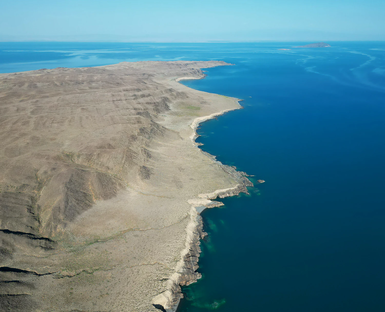
An aerial view of large, arid islands surrounded by deep blue lake water, showcasing a rugged coastline and rocky terrain.
Aerial view of the islands in Alakol Lake within the Alakol Nature Reserve.

Alakol Nature Reserve history and protected-area timeline

Alakol Nature Reserve was formally established on 21 April 1998 by Resolution No. 355 of the Government of Kazakhstan. Its creation was driven by the need to protect the natural complexes of the Tentek River delta and the bird colonies of Lake Alakol's islands, especially the nesting grounds of the relict gull.

In October 2010, the reserve's territory was significantly expanded through Government Resolution No. 1025, which added more than 45,000 hectares by incorporating lands from the Urdzhar district of the former East Kazakhstan Region. This expansion brought the reserve to its current scale of roughly 65,672 hectares and reinforced the protection of its scattered geographic clusters.

International recognition followed relatively quickly. In 2004, the reserve became the focus of a long-term conservation partnership between the Government of Kazakhstan and the United Nations Development Programme, supported by the Global Environment Facility, aimed at safeguarding globally significant wetlands for waterbirds. By 2009, the Alakol-Sasykkol lake system was inscribed on the list of Ramsar wetlands of international importance, and in May 2013, the area was designated a UNESCO Biosphere Reserve under the Man and the Biosphere Programme. In 2018, the reserve marked its 20th anniversary and was recognized as the best-performing organization in the Alakol district that year.

Alakol Nature Reserve landscape and geographic character

The reserve occupies a deep tectonic depression between the Dzungarian Alatau and the Tarbagatai mountains in southeastern Kazakhstan. The relief of the lake area is dominated by a low, terraced plain built from ancient marine and lacustrine saline deposits, with a belt of salt flats, salt meadows, and wetland soils stretching 10 to 25 kilometers around the lakes.

The Alakol basin is fundamentally a desert landscape. Desert soils predominate broadly across the depression, while floodplain terraces along rivers and lakes support alluvial meadow soils under tugai riparian vegetation. In the lower lake margins and marshes, sedge-reed associations grow on meadow-bog soils, and takyr-like soils appear where biyrgun and kokpek vegetation dominates. Ephemeral wormwood steppe on sierozem-like soils is widespread.

The most visually striking landscape elements within the reserve are the islands of Lake Alakol, especially Ulken Araltobe, a large island-hill that rises from the lake's central waters. The combination of open steppe-desert, saline lake shorelines, freshwater deltas, and isolated lake islands gives the reserve an unusually varied scenic character for an arid Central Asian setting.

Alakol Nature Reserve ecosystems, habitats, and plant life

The nature of Alakol Nature Reserve reflects the unusual ecological transition between Central Asian desert, lake, and delta systems. Plant diversity is high: 286 plant species from 61 families have been recorded, representing roughly half of the regional flora, despite the reserve covering only a small fraction of the basin.

Vegetation patterns vary sharply across the protected territory. Tugai riparian forests line river terraces; reeds and sedges dominate the freshwater deltas and the edges of the Tysyachnye Lakes; salt-tolerant plants and ephemerals characterize the saline flats and takyrs; and desert wormwood and saltwort communities cover the broader basin. This mosaic of habitats is the foundation of the reserve's animal diversity, especially its birdlife.

The reserve's ecosystems are tightly linked to the Central Asian-Indian flyway and to the broader Alakol-Sasykkol wetland system. The lakes are shallow to moderately deep and often saline, the deltas are rich in aquatic vegetation, and the islands provide predator-free nesting grounds. Together, these conditions create one of the most ecologically distinctive protected areas in Kazakhstan.

Alakol Nature Reserve wildlife and species highlights

Alakol Nature Reserve is recognized above all as a waterbird sanctuary. The Tentek River delta and the islands of Lake Alakol together form a breeding heartland for colonial birds. Curly-crested and great white pelicans nest here in dense colonies, alongside great cormorants, spoonbills, night herons, common herons, lake gulls, terns, bitterns, and spotted crakes. The diversity is so high that one local lake, Uyalу, is simply named for 'nesting grounds' in Kazakh.

The reserve is particularly important for the relict gull, one of Central Asia's rarest waterbirds, whose nesting colonies on the Alakol islands were first confirmed by the Kazakh ornithologist Yernar Auezov during fieldwork in 1968-1969. Sixteen bird species in the reserve are listed in the Red Book of Kazakhstan, including the curly pelican, the white-headed duck, the black stork, the white spoonbill, the great bustard, and the eagle owl. Sixteen species account for the bulk of the reserve's conservation-relevant avifauna.

Beyond birds, the reserve supports 17 fish species, among them the Balkhash perch (Perca schrenki), an endemic of the Balkhash-Alakol basin, and the Balkhash marinka, a candidate for national Red Book protection. The reserve also shelters two amphibian species and 14 reptile species, two of which, the Danatin toad and the colorful toad-headed agama, are listed in Kazakhstan's Red Book. Insects are still incompletely surveyed, with more than 700 species recorded so far out of an estimated possible 5,000. Mammals, represented by 33 species, round out a vertebrate total of 386 species.

Alakol Nature Reserve conservation status and protection priorities

Alakol Nature Reserve is one of Kazakhstan's most internationally recognized wetland conservation sites. It is classified by the International Union for Conservation of Nature as a Category Ia reserve, the strictest category of protected area, focused on preserving intact natural systems with minimal human interference.

The reserve's conservation significance is amplified by its regional context. The Alakol-Sasykkol lake system was designated a Ramsar Wetland of International Importance in November 2009, and in May 2013 the broader area was accepted into UNESCO's World Network of Biosphere Reserves under the Man and the Biosphere Programme. These designations reflect the system's importance as a breeding, wintering, and stopover habitat for migratory waterbirds on the Central Asian-Indian flyway.

The reserve's conservation work has been supported by long-running international partnerships. Between 2004 and 2011, the UNDP and the Global Environment Facility worked with the Government of Kazakhstan on a project specifically aimed at safeguarding these wetlands as waterbird habitat. A two-kilometer buffer zone around the Alakol islands restricts hunting, fishing, and boating within an area of roughly 5,130 hectares, creating a quiet refuge around the most sensitive nesting grounds. Together, these efforts have established the reserve as a flagship site for wetland and waterbird conservation in Central Asia.

Alakol Nature Reserve cultural meaning and human context

The reserve's cultural context is closely tied to the local Kazakh identity of the Alakol basin. Place names across the lakescape are richly tied to birds and traditional life: Lake Uyalу, for instance, is simply named for nesting grounds in Kazakh, reflecting centuries of local awareness of the area's importance for waterbirds.

The reserve also honors the legacy of the Kazakh ornithologist Yernar Auezov (1943-1995), whose pioneering studies of the birds of the Alakol basin, including the first confirmation of relict gull nesting on the lake islands, shaped the scientific case for the reserve's creation. The reserve's nature museum, opened in 2000, was named in his honor in 2001. Educational programs such as the annual 'March of Parks' and school outreach campaigns in both the Alakol and Urdzhar districts connect the reserve to the everyday life of surrounding communities.

Top sights and standout views in Alakol Nature Reserve

The most distinctive feature of Alakol Nature Reserve is the extraordinary concentration of breeding waterbirds on its lake islands and river deltas, especially on the Araltobe islands of Lake Alakol and in the Tentek River delta. The presence of a major nesting colony of the rare relict gull adds a level of conservation significance that few other Central Asian reserves can match.

Equally important is the reserve's standing in international conservation frameworks. Its integration into both the Ramsar Convention and the UNESCO Man and the Biosphere network makes it a key reference site for understanding and protecting Central Asian-Indian flyway wetlands. The combination of arid basin landscapes, saline lake shores, freshwater deltas, and isolated lake islands also makes the reserve a striking example of ecological diversity within a single protected territory.

Best time to visit Alakol Nature Reserve

The best time to experience the natural character of the Alakol basin falls in the warmer months, when bird colonies are active across the deltas and lake islands. Late spring and summer bring the peak of waterbird breeding activity, with pelicans, cormorants, herons, and gulls visibly concentrated at nesting sites.

Migration seasons also shape the reserve's atmosphere. The Central Asian-Indian flyway passes through the Alakol-Sasykkol system, so spring and autumn bring large numbers of migratory species to the lakes and deltas. Winters are quieter but support their own community of wintering waterbirds. Harsh continental conditions, including hot, dry summers and cold winters, are characteristic of the region and influence both accessibility and the seasonal rhythm of wildlife observation.

Monthly climate preview

Long term monthly temperature and precipitation patterns recorded across representative protected coordinates

Alakol Nature Reserve Climate Normals and Annual Temperature Rhythm

Alakol Nature Reserve records significant long term temperature variation alongside measured monthly precipitation rates across twelve distinct baseline periods. Examining the complete climate profile provides deeper context for analyzing annual weather rhythms and historical meteorological normals.
Annual mean11 °C
-6 °C27 °C
Jan-6°
Feb-3°
Mar
Apr13°
May19°
Jun25°
Jul27°
Aug25°
Sep19°
Oct11°
Nov
Dec-4°
Warmest month
July

26.8 °C

Coolest month
January

-6.3 °C

Wettest month
June

0.9 mm/day

Driest month
September

0.5 mm/day

Park location guide

Geography guide, regional context, and park location map for Alakol Nature Reserve

Alakol Nature Reserve park geography, regions, and map view in Kazakhstan

Understand where Alakol Nature Reserve sits in Kazakhstan through a broader geographic reading of the surrounding landscape, nearby location context, and its mapped position within the national park landscape.

How Alakol Nature Reserve fits into Kazakhstan

Kazakhstan is a Central Asian country spanning vast steppes and plains, bordered by Russia, China, Kyrgyzstan, Uzbekistan, and Turkmenistan, with a coastline along the Caspian Sea. It gained independence from the Soviet Union in 1991 and has a population of approximately 20.5 million people. The country is officially secular but predominantly Muslim, with Kazakh and Russian as official languages.

Wider geography shaping Alakol Nature Reserve in Kazakhstan

Kazakhstan occupies a vast territory in Central Asia, extending into Eastern Europe. Its terrain consists largely of hilly plateaus and plains, with lowlands covering about a third of the area. The southern and eastern regions are mountainous. The country borders Russia to the north and west, China to the east, Kyrgyzstan to the southeast, Uzbekistan to the south, and Turkmenistan to the southwest. It has a coastline along the Caspian Sea.

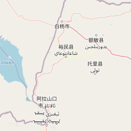
Map view of Alakol Nature Reserve

Use this park location map to pinpoint Alakol Nature Reserve in Kazakhstan, understand its exact geographic position, and read its mapped placement within the surrounding landscape more clearly.

Pigeon | © OpenStreetMap contributors

Explore protected area imagery, lake islands, and desert basin scenery across Kazakhstan.

Alakol Nature Reserve Photos and Landscapes, Visualizing Central Asian Wetlands

Visual documentation captures the stark desert basins, saline shorelines, and vital river deltas defining Alakol Nature Reserve. Photographic records reveal the remote island habitats and wetland environments supporting major colonial waterbird populations.

An aerial view of large, arid islands surrounded by deep blue lake water, showcasing a rugged coastline and rocky terrain.

Park atlas

Compare regional protected landscapes, wetland networks, and basin geography

Explore Other Parks Near Alakol Nature Reserve and Surrounding Protected Areas

Browsing other protected areas near Alakol Nature Reserve reveals the wider ecological patterns of the surrounding Central Asian desert basins. Comparing nearby reserves provides essential context on regional wetlands, mountain fringe ecosystems, and migratory flyways.
National parkEast Kazakhstan Region
About 23 km away#1 closest

North

Tarbagatai National Park: Protected Landscape and Wild Fruit Tree Forests in East Kazakhstan Region

Explore the mapped boundaries and ecosystem of this national park.

Tarbagatai National Park is a protected area in East Kazakhstan recognized for its unique role in conserving wild fruit tree forests that have maintained genetic isolation. This national park provides a detailed view of a mountain-steppe ecosystem across the Tarbagatai mountain range, Karabas Mountains, and Arkaly Mountains, along with the Urzhar and Emel river valleys. Its establishment in 2018 highlights its importance for biodiversity and the study of natural forest genetics, offering significant geographic context for regional protected land exploration.

Area
1,364 km²
Established
2018
IUCN
II
Relief
Mountain
Nature reserveTacheng Prefecture
About 85 km away#2 closest

Southeast

Xinjiang Barkol Mountain National Nature Reserve: Protected Terrain and Regional Geography

Mountain forest sanctuary in Tacheng Prefecture, Xinjiang

The Xinjiang Barkol Mountain National Nature Reserve protects a diverse mountain environment where the Barkol range captures moisture-bearing winds. Known for its globally significant stands of wild almond and Xinjiang wild apple, the reserve features a complex landscape of rocky ridges, forested slopes, and deep river valleys that sustain rare montane species and resilient endemic flora.

Area
1,150.37 km²
Established
1980
Relief
Mountain
Climate
Temperate
Nature reserveXinjiang
About 175 km away#3 closest

Southwest

Xinjiang Wenquan Xinjiang Salamander National Nature Reserve Protected Landscape and Atlas Geography

A vital montane spring and alpine grassland protected area in the Western Tianshan.

The Xinjiang Wenquan Xinjiang Salamander National Nature Reserve serves as a dedicated refuge for relict amphibian populations within the Tianshan mountain system. Its small footprint concentrates on preserving the integrity of cold-water spring brooks and snowmelt-driven seepage zones that form the backbone of this regional ecosystem. The reserve provides a clear example of targeted habitat management within the diverse topography of northwestern China.

Area
6.95 km²
Established
1997
Relief
Mountain
Climate
Arid
Watercolor painting depicting a mountain range, lake, and grassy foreground under a pale sky
National parkAlmaty Region
About 191 km away#4 closest

Southwest

Zhongar-Alatau National Park: Protected Mountain Landscape and Genetic Heritage Atlas

Almaty Region's critical wild apple forest and glaciated terrain.

Zhongar-Alatau National Park in Kazakhstan's Almaty Region is a significant protected landscape renowned for its role in conserving the genetic origins of cultivated apples. The park encompasses dramatic glaciated mountain ranges, deep canyons, and diverse ecosystems within the Dzungarian Alatau. Its mapped boundaries define an area vital for protecting unique wild fruit tree species, including the Sievers apple, and preserving the distinctive alpine terrain of southeastern Kazakhstan, offering rich context for geographic exploration.

Area
36 km²
Established
2010
IUCN
II
Relief
Mountain
Nature reserveXinjiang
About 201 km away#5 closest

Southeast

新疆甘家湖梭梭林国家级自然保护区: Arid Ecosystems and Protected Haloxylon Woodland Mapping

Examining desert terrain and dune geomorphology in northwestern Xinjiang

Explore the structured geography of the Xinjiang Ganjiahu Haloxylon National Nature Reserve, which guards an expansive and ecologically critical saxaul woodland corridor. This protected area stands as a representative example of temperate desert systems in the Ebinur Basin, offering insight into wind-shaped dune landscapes, saline-alkali soil patterns, and the historic riverbeds that once connected Tien Shan meltwater to the regional basin floor.

Area
546.67 km²
Established
1983
Relief
Lowland
Climate
Arid
Nature reserveXinjiang Uyghur Autonomous Region
About 223 km away#6 closest

South

新疆霍城四爪陆龟国家级自然保护区: Mapped Landscape and Tianshan Foothills Geography

Nature reserve boundaries within the Xinjiang Uyghur Autonomous Region

Located in the Xinjiang Uyghur Autonomous Region, the 新疆霍城四爪陆龟国家级自然保护区 represents a unique loess hill ecosystem. This atlas profile details the protected boundaries, erosion-carved terrain, and the semi-arid sagebrush steppe habitat essential for the four-clawed tortoise population, providing deep geographic context for this national nature reserve.

Area
350 km²
Established
1983
Relief
Upland
Climate
Arid
Nature reserveXinjiang
About 276 km away#7 closest

South

新疆伊犁小叶白蜡国家级自然保护区: Regional Protected Landscape and Tianshan Mountain Geography

Conservation focus on rare riparian ash forest ecosystems in Xinjiang

Spanning the alluvial floodplains of the Kashi and Ili Rivers, this nature reserve is a scientific stronghold for the narrow-leaved ash. The protected area showcases multi-generational forest structures and diverse ancient plant lineages, shaped by a sheltered Tianshan valley microclimate that remains unusually humid for the arid landscapes of inland Xinjiang.

Area
91.03 km²
Established
1983
Relief
Mixed relief
Climate
Temperate
Watercolor illustration showing rolling hills, distant mountains, and sparse vegetation
National parkAlmaty Region
About 285 km away#8 closest

Southwest

Altyn-Emel National Park: A Protected Landscape of Singing Dunes and Lunar Mountains

Explore unique geological wonders and ancient Saka history.

Discover Altyn-Emel National Park, a prominent national park located in Kazakhstan's Almaty Region. This protected area showcases an extraordinary diversity of landscapes, from the echoing Singing Dunes to the otherworldly Aktau mountains, often referred to as the 'lunar mountains' due to their vivid mineral hues. As a vital conservation zone, it safeguards Central Asian steppe ecosystems and significant Iron Age archaeological sites, offering a rich tapestry of natural beauty and historical depth for atlas exploration.

Area
4,600 km²
Established
1996
IUCN
II
Relief
Mixed relief

Common questions about visiting, size, designation, and location context for Alakol Nature Reserve

Alakol Nature Reserve FAQs for park facts, access, geography, and protected area context

Find quick answers about Alakol Nature Reserve, including protected-area facts, park geography, trail and visitor context, and how the park fits into its surrounding country and regional landscape.
MoriAtlas Explorer

Continue Your Protected Areas Search Across the Global Atlas

Deepen your exploration by continuing the structured search for national parks and protected areas worldwide. Utilize the comprehensive filtering capabilities to compare different conservation landscapes and refine your understanding of global park geography. Discover more about the distribution and characteristics of protected natural areas.

Global natural geography