

Mori Atlas logo
National parkAlfred National Park

Mapping the unique biogeographic boundary where flora from multiple Australian zones converge.

Alfred National Park: Southernmost Warm Temperate Rainforest Protected Area

Alfred National Park in Victoria represents a critical biogeographic boundary, safeguarding Australia's southernmost warm temperate rainforest at Mount Drummer. This protected national park showcases a unique ecological crossroads where subtropical flora meets species from cooler temperate and arid zones. Its landscape is characterized by a dense, multi-layered rainforest environment, distinct from surrounding eucalyptus forests, offering rich insights into the confluence of diverse Australian vegetation communities.

temperate rainforestVictoria national parksEast Gippslandtree fernsepiphytic orchidsbiogeographic boundary

Alfred National Park

National park

Park overview

Structured park overview, official facts, and landscape profile for Alfred National Park

Alfred National Park park facts, protected area profile, and essential visitor context
Review the core facts for Alfred National Park, including designation, size, terrain, visitor scale, habitats, and operating context in one park-focused overview.

About Alfred National Park

Alfred National Park occupies a remarkable position in Australia's protected area network as one of the southernmost examples of warm temperate rainforest on the continent. Located in East Gippsland, Victoria, the park preserves an ecological community that reaches its geographic limits in this region, making it a critical reference point for understanding Australian rainforest distribution patterns. The park's landscape is characterized by dense, closed-canopy rainforest vegetation that creates a distinctly different atmosphere from the surrounding eucalyptus-dominated forests typical of southeastern Australia. The rainforest community here is supported by the wet, mild climate of the region, which allows species more commonly associated with much warmer climates to survive at these southern latitudes. The park's accessibility along the Princes Highway makes it a geographic landmark for travelers moving between Melbourne and the New South Wales border, though the current closure due to bushfire damage has limited public access to this unique ecosystem.

Quick facts and research context for Alfred National Park

Alfred National Park protects 3,050 hectares of warm temperate rainforest in East Gippsland, Victoria. Established in 1925, it is managed by Parks Victoria. The park is located along the Princes Highway between Cann River and Genoa, approximately 388 kilometres east of Melbourne. The park features the jungle of Mount Drummer and contains four varieties of tree ferns. It is known for epiphytic orchids including the orange-blossom orchid and rock orchid. The park suffered significant damage during the 1983 Ash Wednesday bushfires.

Park context

Deeper park guide and search-rich context for Alfred National Park

Alfred National Park history, landscape, wildlife, and travel context
Explore Alfred National Park through its history, landscape character, ecosystems, wildlife, conservation priorities, cultural context, and seasonal travel timing in a structured park guide built for atlas discovery and search intent.

Why Alfred National Park stands out

Alfred National Park is best known for its warm temperate rainforest ecosystem, which represents the southernmost limit of rainforest flora in Australia. The park protects the Mount Drummer rainforest area, a floristically distinct community compared to northern tropical rainforests. The understory features an exceptional concentration of tree ferns, with four varieties present, alongside epiphytic orchids such as the orange-blossom orchid and rock orchid. The rainforest canopy is dominated by Lilly Pilly, with abundant lianas, ferns, and epiphytes creating a dense, jungle-like environment.

Alfred National Park history and protected-area timeline

Alfred National Park was established in 1925, making it one of Victoria's older national parks. The park was created to preserve the significant warm temperate rainforest community found in the East Gippsland region, recognizing its scientific and ecological importance as a southern outlier of rainforest vegetation. The establishment of the park reflected early conservation priorities in Victoria to protect unique vegetation communities that differed from the more common eucalyptus forests dominating the landscape. The park experienced significant disturbance during the 1983 Ash Wednesday bushfires, which burned extensive areas of the park and demonstrated the vulnerability of these rainforest ecosystems to fire events despite their apparent lushness. The ongoing closure of the park due to more recent bushfire damage reflects the continued challenge of maintaining protected areas in a region subject to periodic severe fire events.

Alfred National Park landscape and geographic character

The landscape of Alfred National Park is dominated by its warm temperate rainforest, a closed-canopy environment quite different from the surrounding eucalyptus forests of East Gippsland. The terrain supports dense vegetation with a multilayered structure typical of mature rainforest: a canopy layer dominated by Lilly Pilly trees, an understory of tree ferns reaching several metres in height, and a ground layer rich in ferns and herbaceous plants. The forest contains numerous lianas climbing between trees and epiphytes growing on branches and trunks, creating the characteristic tangled appearance of mature rainforest. The park's position at the interface between different climatic zones influences the vegetation patterns, with species from subtropical, temperate, and more arid regions all meeting in this relatively limited area.

Alfred National Park ecosystems, habitats, and plant life

The ecological character of Alfred National Park is defined by its warm temperate rainforest community, which represents the southern geographic limit of this vegetation type in Australia. The rainforest here is considered floristically depauperate compared to the lush tropical rainforests of Queensland and New South Wales, reflecting the constraints of cooler southern conditions, yet it contains distinctive elements that make it scientifically valuable. The closed canopy is dominated by Lilly Pilly, which forms a dense crown that limits light penetration to the forest floor. This shade-tolerant environment supports an impressive diversity of ferns, with four varieties of tree ferns present, and epiphytic orchids including the orange-blossom orchid and rock orchid. The park's biogeographic significance stems from its position as a meeting point between the subtropical flora of northern Australia and the cool temperate and arid zone floras of the south and west.

Alfred National Park wildlife and species highlights

While the source material focuses primarily on vegetation, the rainforest ecosystem of Alfred National Park would support various fauna species typical of East Gippsland's wet forests. The dense canopy and structural complexity of the rainforest provide habitat for arboreal mammals, birds, and invertebrates, though specific species are not detailed in the available source. The presence of tree ferns and epiphytic orchids indicates an environment with high humidity and stable microclimates suitable for moisture-dependent organisms. The surrounding eucalyptus forests that border the park add to the habitat diversity available to wildlife, potentially supporting species that utilize both forest types.

Alfred National Park conservation status and protection priorities

Alfred National Park holds significant conservation value as the southernmost example of warm temperate rainforest in Australia, representing a vegetation type at the edge of its ecological tolerance. The park protects a floristic transition zone where subtropical species reach their southern limits while cool temperate and arid-adapted species from the south and west also occur, creating a complex ecological community of scientific interest. The presence of epiphytic orchids and multiple tree fern varieties indicates specialized habitat requirements that rely on the stable, humid conditions within the rainforest. The park's history of fire damage, including the 1983 Ash Wednesday fires, highlights the vulnerability of this ecosystem type and the challenges of managing protected rainforest in a fire-prone landscape.

Alfred National Park cultural meaning and human context

The source material does not provide specific information about indigenous cultural connections to Alfred National Park or traditional land use by Aboriginal peoples in the East Gippsland region. The park's establishment in 1925 reflects the broader conservation movement in early twentieth-century Victoria, which prioritized preserving unique natural environments. East Gippsland has significant Aboriginal heritage, though detailed cultural context specific to the park area is not covered in the available Wikipedia source.

Top sights and standout views in Alfred National Park

Alfred National Park protects the southernmost warm temperate rainforest in Australia at Mount Drummer, featuring a closed canopy of Lilly Pilly with abundant lianas, ferns, and epiphytes. The park contains four varieties of tree ferns and notable orchids including the orange-blossom orchid and rock orchid. Its biogeographic significance lies in representing the meeting point between subtropical and cool temperate flora. The park is currently closed due to bushfire damage.

Best time to visit Alfred National Park

Alfred National Park is currently closed to visitors due to bushfire damage. When reopened, the park would typically be visited during the cooler months of autumn and spring when the rainforest environment is most comfortable for walking and the risk of bushfire is reduced compared to the hot summer months. The wet temperate climate of East Gippsland means that rain can be expected throughout the year, and the forest is likely at its most lush during the wetter winter and spring periods.
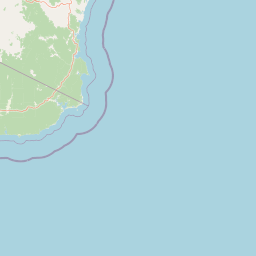
Park location guide

Geography guide, regional context, and park location map for Alfred National Park

Alfred National Park park geography, regions, and map view in Australia
Understand where Alfred National Park sits in Australia through a broader geographic reading of the surrounding landscape, nearby location context, and its mapped position within the national park landscape.

How Alfred National Park fits into Australia

Australia is a constitutional monarchy and federal parliamentary democracy comprising six states and ten territories. With a population of nearly 28 million, it is one of the world's most urbanised countries, with most people concentrated on the eastern seaboard. The country has a high Human Development Index and is known for its cultural diversity, ancient Aboriginal heritage, and unique wildlife.

Wider geography shaping Alfred National Park in Australia

Australia occupies the entire Australian continent, the island of Tasmania, and numerous smaller islands. It is the world's flattest and driest inhabited continent, featuring vast deserts in the interior (the Outback), tropical rainforests along the eastern coast, and a coastline bordering the Indian and Pacific Oceans.

Map view of Alfred National Park

Use this park location map to pinpoint Alfred National Park in Australia, understand its exact geographic position, and read its mapped placement within the surrounding landscape more clearly.

Pigeon | © OpenStreetMap contributors
Park atlas

Compare regional protected areas and diverse landscapes near Alfred National Park in East Gippsland, Victoria.

Explore Other National Parks and Protected Areas Near Alfred National Park
Browse additional national parks and protected areas situated within the broader geographic context of Alfred National Park, tracing the regional spread of diverse conservation landscapes. Discover how different ecosystems, from unique temperate rainforests to surrounding eucalypt forests, are protected, offering a valuable comparative view of Victoria's East Gippsland region.
Marine protected area

Point Hicks Marine National Park: Protected Marine Landscape and Geographic Context

Explore Victoria's unique transitional marine ecosystems and mapped underwater geography.

Point Hicks Marine National Park represents a crucial marine protected area within Victoria, Australia, safeguarding a unique ecological transition zone. The park's underwater geography features a dynamic interplay of rocky reefs and sandy bottoms, supporting a rich diversity of marine life where species from distinct biogeographic regions overlap. Understanding Point Hicks Marine National Park means exploring its protected marine identity, its mapped underwater landscapes, and its critical role in conserving Australia's warmer eastern marine environments.

Area
40 km²
Established
2002
IUCN
II
Relief
Lowland
National park

Coopracambra National Park: Remote Mountainous Protected Landscape in Victoria

Explore its transboundary wilderness role and tall forest terrain.

Coopracambra National Park stands as a significant protected landscape in Victoria, Australia, renowned for its rugged mountainous terrain and extensive tall eucalypt forests. This remote national park serves as the crucial Victorian component of a vast transboundary wilderness corridor, linking protected areas across the state border into New South Wales. Its geographic identity is shaped by prominent peaks such as Mount Coopracambra and the unique Black-Allan Line boundary, offering users a detailed atlas view of its conservation significance and natural features within south-eastern Australia.

Area
388 km²
Established
1988
IUCN
II
Relief
Mountain
National park

Lind National Park: Historic Protected Landscape in East Gippsland, Victoria

Explore mapped boundaries and forested terrain within this early national park.

Lind National Park, established in 1925, is a key protected area in Victoria, Australia, preserving the characteristic forested landscapes of East Gippsland. Spanning 1,370 hectares, it offers a tangible connection to the state's early conservation efforts. The park's terrain is defined by temperate forest, characteristic of eastern Victoria's undulating geography, providing a clear example of protected woodland adjacent to the Princes Highway corridor. Its historical designation underscores its importance in the region's network of natural reserves and mapped landscapes.

Area
13.7 km²
Established
1925
IUCN
II
Visitors
3.5K annual
National parkAustralia

Errinundra National Park: Australia's National Park Geographic Identity and Mapped Boundaries

Explore the protected landscape and natural terrain of this Australian national park.

Errinundra National Park offers a unique window into Australia's protected natural areas. This detailed view focuses on its role as a national park, providing structured information on its geographic footprint, mapped terrain, and position within the broader Australian landscape. Understand Errinundra National Park as a distinct entity for atlas-based discovery, focusing on its protected land characteristics and geographic context without visitor logistics.

Area
268.75 km²
Established
1988
IUCN
II
Relief
Upland
Marine protected area

Cape Howe Marine National Park: Victoria's Southeastern Marine Protected Landscape

Rugged coast, Southern Ocean influence, and marine conservation.

Cape Howe Marine National Park offers a protected marine environment at the remote eastern edge of Victoria, Australia. Defined by its dramatic coastal geography, the park features rocky headlands, exposed cliffs, and waters influenced by the powerful Southern Ocean. Established in 2002, this marine protected area contributes to a significant continuum of protected lands, adjacent to terrestrial national parks. Its landscape is shaped by powerful surf and coastal wilderness, providing a unique example of marine conservation where the Australian continent meets the open ocean.

Area
40.5 km²
Established
2002
IUCN
II
Climate
Temperate
National parkNew South Wales

Mount Imlay National Park: Protected Land Geography and Mapped Boundaries in New South Wales

Explore the geographic context of this Australian national park.

Mount Imlay National Park serves as a significant protected area within New South Wales, providing a focal point for understanding regional geography and mapped natural landscapes. As a national park, its boundaries and terrain offer valuable insights for atlas-based discovery, highlighting Australia's commitment to conserving diverse geographic entities and showcasing its role in the broader national landscape context.

Area
48 km²
Established
1972
IUCN
II
Relief
Mountain
National parkNew South Wales

South East Forests National Park: New South Wales National Park Atlas Entry

Mapped landscape and protected area geography.

This canonical MoriAtlas entry for South East Forests National Park provides essential geographic context and details about its status as a national park. Understand the mapped boundaries of this protected landscape within New South Wales, supporting discovery through its regional setting and natural terrain. The focus remains on atlas-style exploration of its geographic identity and conservation significance, devoid of visitor logistics or travel advice.

Area
1,151.77 km²
Established
1997
IUCN
II
Relief
Highland
National parkNew South Wales

Beowa National Park: Protected Landscape and Coastal Geography in New South Wales

Mapped terrain and unique erosion sites within this national park.

Delve into the protected landscape of Beowa National Park, situated in the coastal region of New South Wales. This national park showcases a varied terrain, from heathland headlands to eucalypt woodlands, with the visually dramatic Pinnacles erosion gully as a key highlight. Its geographic setting within Twofold Bay provides a compelling focus for atlas exploration of Australia's protected natural areas.

Area
104.86 km²
Established
1971
IUCN
II
Relief
Lowland

Common questions about visiting, size, designation, and location context for Alfred National Park

Alfred National Park FAQs for park facts, access, geography, and protected area context
Find quick answers about Alfred National Park, including protected-area facts, park geography, trail and visitor context, and how the park fits into its surrounding country and regional landscape.
MoriAtlas Explorer

Continue Your Protected Areas Search Across the Global Atlas

Deepen your exploration by continuing the structured search for national parks and protected areas worldwide. Utilize the comprehensive filtering capabilities to compare different conservation landscapes and refine your understanding of global park geography. Discover more about the distribution and characteristics of protected natural areas.

Global natural geography