

Mori Atlas logo
National parkErrinundra National Park

Trace the mapped boundaries and natural terrain of this significant national park in Australia.

Errinundra National Park: Discover Australia's Protected Landscape and Geographic Context

Errinundra National Park stands as a key protected area within Australia's vast geography. This page provides an atlas-centric view, helping users understand the park's mapped boundaries, its regional landscape context, and its identity as a national park. Explore the fundamental geographic characteristics that define Errinundra National Park and its contribution to Australia's protected lands.

Cool Temperate RainforestOld-Growth ForestVictoriaGippslandNational ParkMountainous Terrain

Errinundra National Park

National park

Park overview

Structured park overview, official facts, and landscape profile for Errinundra National Park

Errinundra National Park park facts, protected area profile, and essential visitor context
Review the core facts for Errinundra National Park, including designation, size, terrain, visitor scale, habitats, and operating context in one park-focused overview.

About Errinundra National Park

Errinundra National Park represents one of Victoria's most significant conservation achievements, protecting a substantial area of cool temperate rainforest that was once far more widespread across the region's mountain ranges. The park's location on the Errinundra Plateau places it at the southern extent of the Monaro Tablelands, creating a unique intersection of ecosystems where northern and southern Australian flora and fauna overlap. The protected area serves as a critical refuge for old-growth forest communities that have survived logging pressure in surrounding landscapes, preserving genetic reservoirs and ecological processes that cannot be replicated in younger regrowth forests. The park's remote location and limited access during wetter months have contributed to its relatively intact condition, though historical logging affected areas both surrounding and within the park boundaries. Visitors to Errinundra experience a landscape of profound natural complexity, where moss-draped trees, fern-filled understories, and canopy gaps create an atmosphere distinctly different from more familiar Australian eucalypt-dominated forests.

Quick facts and research context for Errinundra National Park

Errinundra National Park occupies 26,875 hectares in Victoria's Gippsland region, established on 15 July 1988 under management by Parks Victoria. The park encompasses the Errinundra Plateau, a highland area forming part of the Monaro Tablelands extension from New South Wales. It contains Victoria's largest cool temperate rainforest alongside warm temperate rainforest, wet open forest, montane forests, woodlands, and a sub-alpine wetland. Notable threatened species include powerful owls, tiger quolls, and long-footed potoroos. The park is near the small locality of Club Terrace.

Park context

Deeper park guide and search-rich context for Errinundra National Park

Errinundra National Park history, landscape, wildlife, and travel context
Explore Errinundra National Park through its history, landscape character, ecosystems, wildlife, conservation priorities, cultural context, and seasonal travel timing in a structured park guide built for atlas discovery and search intent.

Why Errinundra National Park stands out

Errinundra National Park is best known for preserving the largest cool temperate rainforest in Victoria, a rare and ecologically significant forest type in Australian terms. The park contains some of south-eastern Australia's most spectacular old-growth forests, with towering trees, complex canopy structures, and ecological communities that have developed over centuries. The diversity of vegetation communities, ranging from cool and warm temperate rainforests through wet open forests to montane woodlands and sub-alpine wetlands, creates a remarkably varied landscape within a single protected area. These habitats support significant populations of rare and threatened fauna species.

Errinundra National Park history and protected-area timeline

Errinundra National Park was officially established on 15 July 1988, representing the culmination of decades of advocacy by conservationists seeking protection for Victoria's remaining temperate rainforests. The establishment of the park came after extensive clearing and logging had removed much of the original forest cover from the Gippsland region, making the preservation of the Errinundra Plateau's forests critically important. Prior to formal protection, significant areas within what is now the park had been subjected to logging operations, and the creation of the national park boundary was not without controversy or administrative challenges. Some logging occurred within the park's boundaries due to administrative errors in the early years following establishment, highlighting the complex transition from timber production to conservation management. The park now falls under the management of Parks Victoria, which works to protect its ecological values while providing limited public access that is compatible with conservation objectives.

Errinundra National Park landscape and geographic character

The Errinundra National Park is characterised by a mountainous plateau landscape rising from the surrounding Gippsland lowlands, with elevations supporting distinct environmental gradients across the protected area. The Errinundra Plateau forms a highland core with elevations that create cooler temperatures and higher rainfall than the surrounding plains, conditions essential for the maintenance of cool temperate rainforest communities. The terrain includes steep valleys, ridgelines, and plateaus that channel water flow across the landscape, feeding the streams and wetlands that dot the park. Forest-covered slopes rise through wet eucalypt forest to the cool, misty environments of the rainforest gullies, creating a tapestry of vegetation that changes with altitude and aspect. A sub-alpine wetland adds further diversity to the landscape, representing a rare ecosystem type in the Victorian context.

Errinundra National Park ecosystems, habitats, and plant life

The ecological character of Errinundra National Park is defined by its diverse forest communities, which range from cool temperate rainforest through warm temperate rainforest to wet open forest and montane woodlands. The cool temperate rainforest represents the park's most significant ecological asset, dominated by species such as myrtle beech and southern beech that form dense, shaded understories with abundant ferns, mosses, and lichens. These rainforests occur in the wettest positions in the landscape, typically on southerly aspects and in gullies where moisture accumulation supports the maintenance of humidity-dependent communities. The surrounding wet open forests contain messmate stringybark and mountain grey gum, while higher elevations support montane communities adapted to cooler conditions. The sub-alpine wetland provides an entirely different habitat type, supporting vegetation adapted to waterlogged conditions and providing ecological diversity within the protected area.

Errinundra National Park wildlife and species highlights

Errinundra National Park provides crucial habitat for several rare and threatened animal species, making it significant for conservation beyond its botanical values. The powerful owl, one of Australia's largest owl species, hunts through the park's forests, preying on arboreal mammals and birds in the old-growth canopy. The tiger quoll, Australia's largest remaining marsupial carnivore, persists in the park's wet forest habitats where it hunts small mammals and ground-dwelling prey. The long-footed potoroo, a small marsupial related to kangaroos, inhabits the forest floor environments where it forages for fungi, roots, and invertebrates. These species represent a cross-section of the park's vertebrate fauna, which also includes various possums, gliders, bandicoots, and an assortment of bird species adapted to the complex forest environments.

Errinundra National Park conservation status and protection priorities

The protection of Errinundra National Park is significant at both state and national levels, preserving forest types and species that have been dramatically reduced across their former ranges. The cool temperate rainforest within the park represents the largest remaining example of this ecosystem type in Victoria, making it irreplaceable for the long-term survival of rainforest-dependent species. Old-growth forests, with their accumulated dead wood, hollow-bearing trees, and complex canopy structures, provide essential habitat features that cannot be recreated in planted or regrowing forests. The presence of multiple threatened species indicates the park's importance as a refugium for fauna that has been lost from more intensively modified surrounding landscapes. Conservation management focuses on maintaining ecological integrity, controlling access to prevent disturbance to sensitive areas, and working to restore connections where historical logging created fragmentation.

Errinundra National Park cultural meaning and human context

The Errinundra region has limited documented indigenous cultural heritage information available in the source material, but the broader Gippsland region contains evidence of Aboriginal occupation spanning tens of thousands of years. The mountainous terrain and abundant forest resources would have provided traditional owners with various food sources, materials, and cultural places. The park's relatively recent establishment as a protected area occurred within a historical context where Aboriginal connection to Victorian lands had been largely severed through colonisation and dispossession. Modern conservation management increasingly recognises the importance of incorporating indigenous perspectives and knowledge where appropriate, though detailed cultural context specific to the Errinundra area is not extensively documented in the available source material.

Top sights and standout views in Errinundra National Park

Errinundra National Park offers visitors the opportunity to experience Victoria's finest cool temperate rainforest, with towering trees, cascading streams, and the misty atmosphere characteristic of these rare ecosystems. The park contains some of the largest old-growth trees in the state, with some specimens exceeding several hundred years of age and supporting complex communities of epiphytic plants and hollow-dependent fauna. The diversity of forest types within a single park creates varied visual landscapes, from the dark, enclosed environments of rainforest gullies to the more open canopy of wet eucalypt forests. The threatened species present in the park, including powerful owls and tiger quolls, represent flagship conservation values that distinguish Errinundra from more common forest parks.

Best time to visit Errinundra National Park

The Errinundra National Park is best visited during the warmer, drier months from late spring through early autumn, typically November through April, when access is more reliable and weather conditions are more comfortable for exploration. During winter and into early spring, the unsealed roads within and approaching the park become impassable due to heavy rainfall and occasional snow, effectively limiting access to the peak summer period. The summer months offer the clearest conditions for walking and observing the forest, though afternoon thunderstorms can occur in the mountain environment. The drier season also provides better opportunities for wildlife viewing as animals become more active around water sources and forest edges.

Park location guide

Geography guide, regional context, and park location map for Errinundra National Park

Errinundra National Park park geography, regions, and map view in Australia
Understand where Errinundra National Park sits in Australia through a broader geographic reading of the surrounding landscape, nearby location context, and its mapped position within the national park landscape.

How Errinundra National Park fits into Australia

Australia is a constitutional monarchy and federal parliamentary democracy comprising six states and ten territories. With a population of nearly 28 million, it is one of the world's most urbanised countries, with most people concentrated on the eastern seaboard. The country has a high Human Development Index and is known for its cultural diversity, ancient Aboriginal heritage, and unique wildlife.

Wider geography shaping Errinundra National Park in Australia

Australia occupies the entire Australian continent, the island of Tasmania, and numerous smaller islands. It is the world's flattest and driest inhabited continent, featuring vast deserts in the interior (the Outback), tropical rainforests along the eastern coast, and a coastline bordering the Indian and Pacific Oceans.

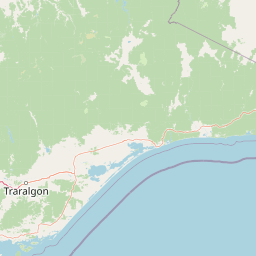
Map view of Errinundra National Park

Use this park location map to pinpoint Errinundra National Park in Australia, understand its exact geographic position, and read its mapped placement within the surrounding landscape more clearly.

Pigeon | © OpenStreetMap contributors
Park atlas

Trace the regional spread of conservation landscapes and compare protected areas across Victoria's diverse terrain.

Explore Related National Parks and Protected Landscapes Near Errinundra National Park
Explore additional national parks and protected areas near Errinundra National Park, tracing similar old-growth forest and cool temperate rainforest ecosystems across Victoria's diverse Gippsland region. Compare these conservation landscapes by their distinct geographic features and protected-area designations to enhance your atlas-based discovery.
National park

Coopracambra National Park: Remote Mountainous Protected Landscape in Victoria

Explore its transboundary wilderness role and tall forest terrain.

Coopracambra National Park stands as a significant protected landscape in Victoria, Australia, renowned for its rugged mountainous terrain and extensive tall eucalypt forests. This remote national park serves as the crucial Victorian component of a vast transboundary wilderness corridor, linking protected areas across the state border into New South Wales. Its geographic identity is shaped by prominent peaks such as Mount Coopracambra and the unique Black-Allan Line boundary, offering users a detailed atlas view of its conservation significance and natural features within south-eastern Australia.

Area
388 km²
Established
1988
IUCN
II
Relief
Mountain
National park

Snowy River National Park: A Deep Gorge Protected Landscape in Victoria, AU

Explore mapped terrain and vital alpine wilderness boundaries.

Snowy River National Park showcases Victoria's rugged natural geography with its dramatic mountain terrain and the spectacular Little River Gorge, the state's deepest. This national park, classified as a wilderness area for much of its expanse, protects critical habitats and diverse ecosystems across its mapped boundaries. Its significance as a protected landscape within the Australian Alps National Parks makes it a key destination for understanding regional geography and conservation efforts.

Area
987 km²
Established
1979
IUCN
II
Relief
Mountain
National park

Lind National Park: Historic Protected Landscape in East Gippsland, Victoria

Explore mapped boundaries and forested terrain within this early national park.

Lind National Park, established in 1925, is a key protected area in Victoria, Australia, preserving the characteristic forested landscapes of East Gippsland. Spanning 1,370 hectares, it offers a tangible connection to the state's early conservation efforts. The park's terrain is defined by temperate forest, characteristic of eastern Victoria's undulating geography, providing a clear example of protected woodland adjacent to the Princes Highway corridor. Its historical designation underscores its importance in the region's network of natural reserves and mapped landscapes.

Area
13.7 km²
Established
1925
IUCN
II
Visitors
3.5K annual
National park

Alfred National Park: Southernmost Warm Temperate Rainforest Atlas and Protected Landscape

Explore a unique biogeographic boundary and diverse rainforest ecosystem.

Alfred National Park stands as a vital protected area, renowned for harboring Australia's southernmost warm temperate rainforest. Located in Victoria's East Gippsland region, this national park is a significant ecological meeting point, where plant communities from subtropical, temperate, and arid zones converge. The park's mapped landscape features a dense, jungle-like environment dominated by Lilly Pilly, tree ferns, and epiphytes, offering a distinct contrast to the typical eucalyptus woodlands of the area and highlighting its unique floristic character.

Area
30.5 km²
Established
1925
IUCN
II
Climate
Temperate
National parkNew South Wales

South East Forests National Park: New South Wales National Park Atlas Entry

Mapped landscape and protected area geography.

This canonical MoriAtlas entry for South East Forests National Park provides essential geographic context and details about its status as a national park. Understand the mapped boundaries of this protected landscape within New South Wales, supporting discovery through its regional setting and natural terrain. The focus remains on atlas-style exploration of its geographic identity and conservation significance, devoid of visitor logistics or travel advice.

Area
1,151.77 km²
Established
1997
IUCN
II
Relief
Highland
Marine protected area

Point Hicks Marine National Park: Protected Marine Landscape and Geographic Context

Explore Victoria's unique transitional marine ecosystems and mapped underwater geography.

Point Hicks Marine National Park represents a crucial marine protected area within Victoria, Australia, safeguarding a unique ecological transition zone. The park's underwater geography features a dynamic interplay of rocky reefs and sandy bottoms, supporting a rich diversity of marine life where species from distinct biogeographic regions overlap. Understanding Point Hicks Marine National Park means exploring its protected marine identity, its mapped underwater landscapes, and its critical role in conserving Australia's warmer eastern marine environments.

Area
40 km²
Established
2002
IUCN
II
Relief
Lowland
National parkNew South Wales

Mount Imlay National Park: Protected Land Geography and Mapped Boundaries in New South Wales

Explore the geographic context of this Australian national park.

Mount Imlay National Park serves as a significant protected area within New South Wales, providing a focal point for understanding regional geography and mapped natural landscapes. As a national park, its boundaries and terrain offer valuable insights for atlas-based discovery, highlighting Australia's commitment to conserving diverse geographic entities and showcasing its role in the broader national landscape context.

Area
48 km²
Established
1972
IUCN
II
Relief
Mountain
National parkNew South Wales

Beowa National Park: Protected Landscape and Coastal Geography in New South Wales

Mapped terrain and unique erosion sites within this national park.

Delve into the protected landscape of Beowa National Park, situated in the coastal region of New South Wales. This national park showcases a varied terrain, from heathland headlands to eucalypt woodlands, with the visually dramatic Pinnacles erosion gully as a key highlight. Its geographic setting within Twofold Bay provides a compelling focus for atlas exploration of Australia's protected natural areas.

Area
104.86 km²
Established
1971
IUCN
II
Relief
Lowland

Common questions about visiting, size, designation, and location context for Errinundra National Park

Errinundra National Park FAQs for park facts, access, geography, and protected area context
Find quick answers about Errinundra National Park, including protected-area facts, park geography, trail and visitor context, and how the park fits into its surrounding country and regional landscape.
MoriAtlas Explorer

Continue Your Protected Areas Search Across the Global Atlas

Deepen your exploration by continuing the structured search for national parks and protected areas worldwide. Utilize the comprehensive filtering capabilities to compare different conservation landscapes and refine your understanding of global park geography. Discover more about the distribution and characteristics of protected natural areas.

Global natural geography