
Lakes
Park geography
Review recorded regional administrative boundaries, landscape metrics, and mountain geography.
Altai Tavan Bogd National Park Geographic Profile, Boundary Map, and Terrain Context
The geographic profile for Altai Tavan Bogd National Park covers its mountain terrain and regional landscape within Bayan-Ölgii Province. This structured data includes boundary area metrics, spatial spans, and a collection of named peaks and saddles located within the protected area. Use these records to analyze the physical extent and land distribution of this high-altitude region.
Related tags
Alpine mountainsRock art and petroglyphsGlacial lakesSnow leopard habitatWorld Heritage Site
Mongolia's sacred five-peak massif and ancient petroglyphic heartland
Altai Tavan Bogd National Park
Altai Tavan Bogd National Park occupies a dramatic corner of western Mongolia in Bayan-Ölgii Province, protecting the Mongolian side of the Tavan Bogd massif, a towering alpine ridge known locally as the Five Saints. The park spans 6,362 square kilometers of rugged mountain terrain where Mongolia meets Russia and China at a rare triple border point. This protected landscape encompasses high-altitude tundra, glacial valleys, pristine alpine lakes, and extensive river systems that drain northward toward the Irtysh basin. The region holds exceptional significance as both a ecological sanctuary for rare alpine species and as one of Central Asia's most important archaeological zones, with thousands of prehistoric petroglyphs etched into the sandstone cliffs of the Tsagaan Salaa valley.
- Location
- Mongolia
- Park type
- National park
- Established
- 1996
- Area
- 6,362 km²
Location overview
Transboundary territory within Mongolia and Bayan-Ölgii Province
Altai Tavan Bogd National Park Geographic Profile and Location
Altai Tavan Bogd National Park spans key regional territories across Mongolia, Bayan-Ölgii Province, and American Samoa. The transboundary status highlights its complex administrative geography across national borders.
- Countries
- Mongolia
- Regions
- Bayan-Ölgii Province
- Primary location
- Bayan-Ölgii Province
- Geographic setting
- Transboundary · Inland
Boundary and coordinates
Analyzing the spatial extent and regional coordinates of the protected area
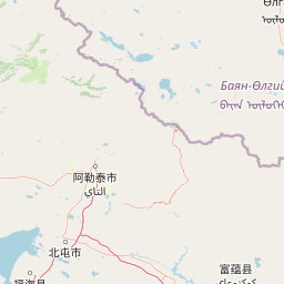
Mapped Geographic Boundaries of Altai Tavan Bogd National Park
Interactive spatial mapping traces the perimeter and geographic footprint of Altai Tavan Bogd National Park. Spatially derived measurements outline the documented area, coordinate limits, and central geographic coordinates.
- Boundary area
- 6,380.7 km²
- Boundary perimeter
- 540.1 km
- Northernmost point
- 49.2608° N
- Southernmost point
- 47.9762° N
- Easternmost point
- 89.5263° E
- Westernmost point
- 87.7346° E
- Geographic centre
- 48.5786° N, 88.5557° E
- North–south span
- 142.8 km
- East–west span
- 132.1 km
Terrain and natural features
Mountain classification and recorded water and peak features
Altai Tavan Bogd National Park Terrain and Named Natural Features
Mountain terrain classifications structure the regional topography alongside recorded lakes, rivers, and peaks within the protected landscape. Linked feature cards supply verified names, types, and spatial relationships for each recorded natural landmark.
Selected named natural features
Rivers
Цаган-Ус
Rivers
Их тургэний гол
Rivers
Жалангаш гол
Peaks
Дунд-Уйгар
3,529.3 m
Rivers
Ут хайтун гол
Environmental setting
Interpreting stored mountain terrain, lake features, and physical geography settings
Environmental Classifications and Relief Settings for Altai Tavan Bogd National Park
Recorded landscape features and relief categories frame the physical setting of Altai Tavan Bogd National Park as complementary data points. Connected atlas destinations link these stored classifications directly to related regional protected areas.
- Relief
- Mountain
- Water
- Minor water
Landscape features
Mountains · Lakes
Park atlas
Explore the regional protected-area spread and connected landscapes surrounding Altai Tavan Bogd
Discover Nearby National Parks and Protected Areas Around Altai Tavan Bogd National Park
Discover other national parks and protected areas near Altai Tavan Bogd National Park, mapping the diverse alpine mountain terrain and glacial valleys of the Central Asian Altai. This regional overview helps compare similar protected landscapes, offering deeper geographic context for major conservation sites, ancient rock art, and critical wildlife habitats.
National parkEast Kazakhstan Region
37 km away#1 closest
Northwest

Katon-Karagay National Park: Discover Kazakhstan's Largest Protected Mountain Landscape
Explore the geography and park boundaries of East Kazakhstan's premier national park.
Katon-Karagay National Park, the largest national park in Kazakhstan, offers a deep dive into the protected landscapes of the Southern Altai Mountains. This page provides essential geographic context, detailing the park's terrain, its significance as a protected area within East Kazakhstan Region, and its role in mapping the natural contours of this ecologically diverse mountain system. Understand the park's boundaries and its contribution to regional conservation.
- Area
- 6,435 km²
- Established
- 2001
- IUCN
- II
- Relief
- Mountain
National parkAltai Republic
About 38 km away#2 closest
North

Saylyugemsky National Park: Discover its Protected Landscape and Geographic Significance in Altai Republic
Mapped boundaries and regional landscape context within the Altai Republic.
Delve into Saylyugemsky National Park, a designated national park situated within the vast geographic expanse of Russia's Altai Republic. This canonical page provides detailed insights into its protected landscape, meticulously mapped boundaries, and its contribution to the regional geography. MoriAtlas focuses on structured geographic discovery, enabling a deeper understanding of Saylyugemsky National Park's place within the atlas of protected areas and natural landscapes.
- Area
- 1,183.8 km²
- Established
- 2012
- IUCN
- II
- Relief
- Mountain
Nature reserveXinjiang
About 101 km away#3 closest
Southwest

Altay Kokesu Wetland National Nature Reserve: Protected Landscape and Regional Map
A diverse wetland corridor in the Xinjiang region
Spanning over 300 square kilometers, the Altay Kokesu Wetland National Nature Reserve represents a key protected entity within the Altai grasslands. This area supports a unique hydrological convergence of the Irtysh and Kran rivers, resulting in a rare ecological mosaic of meadows, marshes, and desert-steppe transition zones. Users can explore the reserve's topography and its critical role in maintaining water-fed habitats for regional bird populations.
- Area
- 306.67 km²
- Established
- 2001
- Relief
- Lowland
- Climate
- Arid
National parkBayan-Ölgii Province
About 121 km away#4 closest
East

Tsambagarav Uul National Park: Mapped Protected Landscape in Bayan-Ölgii
Explore its geographic context and park boundaries.
Tsambagarav Uul National Park offers a detailed look at a significant protected landscape situated in Mongolia's western Bayan-Ölgii Province. This national park's boundaries are mapped to provide context within the broader Altai Mountains region. Users can explore the park's geographic setting, understanding its contribution to the protected natural areas of western Mongolia and its significance for regional landscape studies.
- Area
- 1,110 km²
- Established
- 2000
- IUCN
- II
- Relief
- Mountain
Nature reserveEast Kazakhstan Region
About 146 km away#5 closest
West
Markakol Nature Reserve: Mapping the Protected Mountain Landscapes of East Kazakhstan
High-altitude glacial lake and alpine tundra ecosystems
Markakol Nature Reserve protects a remote tectonic depression within the Southern Altai. The area features a complex vertical zonation of fir and spruce forests, subalpine meadows, and alpine tundra, centered around the pristine and ecologically significant Lake Markakol. This protected site serves as a vital study of the intersection between Siberian boreal influences and high-mountain steppe biodiversity.
- Area
- 1,029.71 km²
- Established
- 1976
- IUCN
- Ia
- Relief
- Mountain
Nature reserveAltay Prefecture
About 228 km away#6 closest
Southeast
Xinjiang Bulgan Beaver National Nature Reserve: Regional Geography and Protected Landscape Map
Exploring riverine habitats in the Altay Prefecture foothills.
This protected area centers on a narrow, vital corridor along the Bulgan River. Discover how the riparian forests, freshwater meadows, and valley plains of this nature reserve provide a refuge for the Mengxin beaver. The mapping details a unique, species-focused sanctuary situated along the Sino-Mongolian border within the broader Altai Mountain landscape.
- Area
- 50 km²
- Established
- 1980
- Relief
- Upland
- Climate
- Arid
National parkMongolia
About 240 km away#7 closest
East
Har Us Nuur National Park: A Mapped Protected Landscape in Mongolia's Vast Geography
Explore the geography and atlas context of this national park.
Har Us Nuur National Park is a designated national park offering a unique protected landscape within Mongolia. This page provides context for exploring its geographic features, mapped boundaries, and its significance within the broader atlas of protected areas in East Asia. Understanding Har Us Nuur National Park contributes to a structured appreciation of Mongolia's natural terrains and regional conservation landscapes.
- Area
- 8,503 km²
- Established
- 1997
- Relief
- Mixed relief
- Climate
- Arid
National parkKhovd Province
About 240 km away#8 closest
East
Khar Us Nuur National Park: Geographic and Protected Area Map of Western Mongolia
Wetland habitats and mountain-fed basins in Khovd Province
Khar Us Nuur National Park offers a comprehensive view of the Great Lakes Basin ecology, where freshwater delta inflows meet saline lakes and high mountain catchments. The park is defined by its diverse terrain, ranging from the extensive Agbash island and reed-fringed shorelines to the prominent southern slopes of the Altai Mountains. This protected area is essential for understanding the hydrological and ecological connectivity of the region.
- Area
- 8,503 km²
- Established
- 1997
- IUCN
- II
- Relief
- Mixed relief
MoriAtlas Explorer
Continue Exploring Altai Tavan Bogd National Park's Geographic Atlas
Delve deeper into the mapped terrain and protected landscape of Altai Tavan Bogd National Park. Understanding its place within Bayan-Ölgii Province's regional geography enhances your atlas exploration of Mongolia's natural areas. Discover the structured details that define this significant national park's protected status and geographic boundaries.
Browse next
Global natural geography
Explore related park routes
Explore MoriAtlas Global ParksBrowse All MoriAtlas ParksGlobal Park Map DiscoveryMoriAtlas: Browse All CountriesBrowse All MoriAtlas ContinentsNational Park Environment AtlasGrand Canyon National Park AtlasYellowstone National Park AtlasYosemite National Park Atlas and GeographySerengeti National Park AtlasGalápagos National Park Protected LandscapeBanff National Park Geography and AtlasKruger National Park Atlas EntryUluṟu-Kata Tjuṯa National Park AtlasExplore Uluru-Kata Tjuta National Park GeographyPlitvice Lakes National Park AtlasFiordland National Park Protected LandscapeGreat Smoky Mountains National Park AtlasAfghanistan National Parks and Protected AreasAlbania National Parks and Protected AreasAlgeria National Parks and Protected AreasAmerican Samoa National Parks and Protected AreasAndorra National Parks and Protected AreasAngola National Parks and Protected AreasAntarctica National Parks and Protected AreasAntigua and Barbuda Park List