

Mori Atlas logo
National parkBelezma National Park

Discover the geographic scope and protected landscape identity of Belezma National Park in Batna Province.

Belezma National Park National Park: Mapped Protected Area Boundaries and Regional Geography

Belezma National Park represents a significant protected natural area, offering insights into Algeria's unique geography and conservation landscapes. Situated within Batna Province, this national park provides a distinct focal point for understanding mapped protected boundaries and the regional terrain. Explore the geographic features and protected landscape context that define Belezma National Park for detailed atlas-based discovery.

National ParkMountain ForestAtlas CedarImportant Bird AreaMediterranean EcosystemProtected Area

Belezma National Park

National park

Park overview

Structured park overview, official facts, and landscape profile for Belezma National Park

Belezma National Park park facts, protected area profile, and essential visitor context
Review the core facts for Belezma National Park, including designation, size, terrain, visitor scale, habitats, and operating context in one park-focused overview.

About Belezma National Park

Belezma National Park occupies a mountainous enclave within the Aurès region of northeastern Algeria, protecting a crucial segment of the Belezma Range that forms a southern outlier of the Atlas Mountains system. The park's terrain is characterized by rugged mountain ridges, steep forested slopes, and alpine meadows that transition from the lower foothills to the highest summits exceeding 2,100 meters. This elevation range, combined with the park's position at the intersection of Mediterranean and Saharan climatic influences, creates a diverse mosaic of habitats that supports exceptional biodiversity. The Atlas cedar forests represent the park's most ecologically significant feature, forming extensive woodland covers on north-facing slopes and in valley bottoms where moisture conditions favor their development. These forests also contain holm oak and juniper in mixed stands, creating a layered canopy structure typical of Mediterranean montane ecosystems. The park's designation as a national park in 1984 reflected Algeria's commitment to preserving these relatively intact mountain ecosystems, which face pressures from logging, grazing, and climate change across their range.

Quick facts and research context for Belezma National Park

Belezma National Park is situated in Batna Province, approximately 20 kilometers northeast of Batna City, in the Aurès region of eastern Algeria. The protected area spans 262.5 square kilometers of mountain terrain within the Belezma Range, with elevations ranging from lower foothills to summits exceeding 2,100 meters. The park was established in 1984 and holds IUCN Category II designation as a national park. It contains the largest remaining habitat of Atlas cedar (Cedrus atlantica) in the world, a conifer species of significant conservation concern. The park supports 447 plant species, representing approximately 14 percent of Algeria's total flora, alongside 309 animal species including 59 protected species.

Park context

Deeper park guide and search-rich context for Belezma National Park

Belezma National Park history, landscape, wildlife, and travel context
Explore Belezma National Park through its history, landscape character, ecosystems, wildlife, conservation priorities, cultural context, and seasonal travel timing in a structured park guide built for atlas discovery and search intent.

Why Belezma National Park stands out

Belezma National Park is best known for harboring the largest contiguous habitat of Atlas cedar in the Mediterranean region, making it globally significant for the conservation of this iconic conifer species. The park's designation as an Important Bird Area by BirdLife International reflects its exceptional avifauna, with the mountain forests and alpine zones supporting significant populations of bird species. The dramatic mountain scenery of the Belezma Range, with its steep forested slopes rising above the surrounding high plains, provides a striking contrast to the semi-arid landscapes typical of inland Algeria. The combination of historical sites, including caves and ancient tombs, with the park's natural values creates a distinctive cultural-ecological heritage.

Belezma National Park history and protected-area timeline

Belezma National Park was created in 1984 as part of Algeria's expanding national park system during a period when the country sought to formalize protection for its most significant natural areas. The establishment of the park came at a time when awareness of environmental conservation was growing in North Africa, and Algeria sought to protect representative samples of its diverse ecological zones. The Belezma Range had long been recognized for its ecological importance, particularly for its extensive cedar forests, but protection mechanisms prior to 1984 were limited. The park's formal designation provided legal framework for managing the cedar forests, controlling grazing pressures, and regulating development within the mountain zone. The creation of the park also recognized the historical significance of the area, with the park containing evidence of ancient human occupation through caves, tombs, and other archaeological sites that represent traces of earlier civilizations that inhabited this mountain landscape.

Belezma National Park landscape and geographic character

The physical landscape of Belezma National Park is defined by the mountainous terrain of the Belezma Range, which rises abruptly from the surrounding high plains of the Aurès region. The park encompasses a series of parallel ridges and valleys oriented roughly east-west, with the highest terrain concentrated in the central and eastern portions of the protected area. Djebel Tichaou reaches 2,136 meters while Djebel Refaâ attains 2,178 meters, making the latter the highest summit in the Belezma Range. The terrain features steep slopes, often exceeding 30 degrees, with rocky outcrops and cliff faces in the upper elevations. Lower slopes transition into gentler foothills and valleys where watercourses have carved alluvial corridors. The geological substrate consists primarily of sedimentary rocks, with limestone and sandstone formations contributing to the varied terrain. The combination of elevation, aspect, and substrate creates diverse microenvironments across the park, from dry south-facing slopes to moister north-facing cedar forests.

Belezma National Park ecosystems, habitats, and plant life

The ecological character of Belezma National Park is defined by its Mediterranean montane forest ecosystems, which represent a critical refuge for species adapted to cool, moist conditions at southern latitudes. The park contains the largest habitat of Atlas cedar in the world, with these conifers forming extensive pure and mixed stands across the middle and upper elevations. The Atlas cedar is considered a glacial relict species, persisting in favorable mountain habitats since the cooler climatic periods when its range was more extensive. Beyond the cedars, the park supports holm oak forests in lower elevations and juniper formations on drier sites, creating a vertical zonation of forest types responding to temperature and moisture gradients. The understory vegetation includes diverse shrubs and herbaceous species adapted to the seasonal climate, which ranges from cool subhumid conditions at higher elevations to dry semi-arid conditions in the lower foothills. This habitat mosaic supports remarkable plant diversity, with 447 species recorded representing approximately 14 percent of Algeria's total flora.

Belezma National Park wildlife and species highlights

Belezma National Park supports 309 animal species, including 59 protected species, within its diverse mountain habitats. The birdlife is particularly significant, earning the park its Important Bird Area designation from BirdLife International. The cedar and oak forests provide breeding habitat for various raptor species and forest-dwelling birds, while the alpine meadows and rocky areas support mountain-specialist species. The park's location along the southern edge of the Mediterranean basin positions it along migratory flyways, with seasonal movements of birds between European breeding grounds and African wintering areas. Mammal populations include species typical of North African mountain environments, though detailed species inventories in the source material are limited. The protected status of 59 species within the park reflects the conservation significance of these habitats for wildlife, particularly for species facing pressures across their ranges in the region.

Belezma National Park conservation status and protection priorities

Belezma National Park represents one of Algeria's most important conservation areas, serving as the primary refuge for the largest remaining Atlas cedar forest in the world. This conservation significance extends beyond national boundaries, as the Atlas cedar populations in Algeria represent the species' core distribution and are critical for long-term survival of this iconic conifer. The park's designation as an Important Bird Area highlights its international importance for bird conservation, with significant populations of species dependent on Mediterranean mountain forest habitats. The diversity of protected species, including both flora and fauna, reflects the ecological richness that the park maintains. The biosphere reserve designation, which includes historical and cultural sites alongside the natural habitats, indicates an integrated approach to conservation that recognizes the connections between cultural heritage and ecological values. Management challenges include balancing traditional land uses such as grazing with habitat protection, addressing climate change impacts on cedar forests, and maintaining connectivity across the mountain landscape.

Belezma National Park cultural meaning and human context

Belezma National Park contains evidence of human occupation spanning considerable time depth, with caves, tombs, and other historical sites distributed throughout the mountain landscape. These archaeological remains represent traces of ancient civilizations that inhabited the Belezma Range region, likely drawn to the resources that the mountain environments provided. The park's inclusion within a biosphere reserve framework reflects recognition that natural and cultural values are intertwined in this landscape. The Aurès region has historical significance in North African history, with Berber communities maintaining presence in these mountainous areas through centuries of political change. The traditional land use patterns, including transhumant grazing, have shaped the landscape over millennia and continue to influence management considerations within the park. The integration of cultural heritage into the conservation framework acknowledges that the park is not a wilderness untouched by humans but a landscape where natural and cultural systems have co-evolved.

Top sights and standout views in Belezma National Park

Belezma National Park offers visitors access to some of the most scenic mountain terrain in eastern Algeria, with the dramatic cedar-covered slopes of the Belezma Range providing a striking backdrop for exploration. The largest Atlas cedar forest in the world represents the park's most distinctive natural feature, with these impressive conifers forming cathedrals of forest that are particularly evocative in the higher elevations. The panoramic views from the mountain summits, particularly from Djebel Refaâ, provide sweeping vistas across the Aurès region and toward the Saharan margins beyond. The combination of natural beauty with historical sites, including caves and ancient tombs, offers visitors the opportunity to experience both ecological and cultural heritage. The park's relative proximity to Batna City makes it accessible for day trips while still providing a sense of mountain wilderness distinct from the surrounding plains.

Best time to visit Belezma National Park

The optimal time to visit Belezma National Park depends on the experience sought, with spring and early summer offering the most comfortable conditions for hiking and wildlife observation. The mountain climate features cool subhumid conditions at higher elevations during summer months when temperatures are moderate and vegetation is in active growth. Autumn brings changing colors in the cedar forests and typically clear skies, though temperatures begin to cool significantly as the season progresses. Winter snow can affect access to higher elevations, though the lower forest zones remain accessible and offer a different character. The dry semi-arid conditions in the lower foothills during summer months can make hiking more challenging, while spring typically brings more comfortable temperatures across all elevations. The shoulder seasons of spring and autumn generally provide the most favorable conditions for experiencing the full range of the park's landscapes and ecosystems.

Park location guide

Geography guide, regional context, and park location map for Belezma National Park

Belezma National Park park geography, regions, and map view in Algeria
Understand where Belezma National Park sits in Algeria through a broader geographic reading of the surrounding landscape, nearby location context, and its mapped position within the national park landscape.

How Belezma National Park fits into Algeria

Algeria is a North African country spanning over 2.38 million km², making it the largest country in Africa. It borders the Mediterranean Sea to the north and shares land borders with seven countries. The population exceeds 47 million, with most concentrated in the northern coastal region.

Wider geography shaping Belezma National Park in Algeria

Algeria occupies the central portion of the Maghreb region in North Africa. It is bordered by Tunisia and Libya to the northeast, Niger to the southeast, Mali, Mauritania, and Western Sahara to the southwest, and Morocco to the west. The Mediterranean Sea forms its northern border. The terrain consists of the Tell Atlas mountain range and coastal plains in the north, transitioning to the Sahara desert in the south.

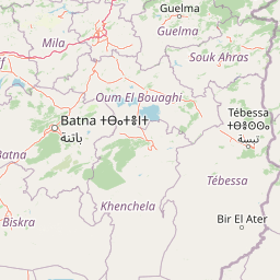
Map view of Belezma National Park

Use this park location map to pinpoint Belezma National Park in Algeria, understand its exact geographic position, and read its mapped placement within the surrounding landscape more clearly.

Pigeon | © OpenStreetMap contributors

Location context for Belezma National Park

Batna Province
Park atlas

Trace surrounding protected landscapes and mountain ranges across the Aurès region of Algeria for broader geographic context.

Explore Related National Parks and Protected Areas Near Belezma National Park
After exploring Belezma National Park, compare its Atlas cedar forests and mountain landscapes with other significant protected areas found across the diverse Algerian interior and adjacent North African regions. This comparative view offers a deeper understanding of regional conservation efforts and reveals the geographic spread of similar high-altitude or forested ecosystems.
National parkJijel Province

Taza National Park: Protected Mediterranean Coast and Tell Atlas Forest Landscape

Explore its unique mapped geography and conservation significance.

Taza National Park, situated in Algeria's Jijel Province, represents a crucial protected landscape where the Tell Atlas mountains meet the Mediterranean Sea. This 3,807-hectare national park is celebrated for its dramatic coastal cliffs, extensive cork oak and gall oak forests, the largest in Algeria, and its designation as a UNESCO biosphere reserve. The park's geography facilitates unique habitat zones, making it a key area for atlas-based discovery of North African biodiversity, including the Barbary macaque and Algerian nuthatch, within a landscape of exceptional natural beauty and conservation priority.

Area
38.07 km²
Established
1923
IUCN
II
Relief
Mountain
National parkKabylie

Djurdjura National Park: A National Park within Algeria's Kabylie Region Landscape

Explore its mapped boundaries and protected area geography.

Djurdjura National Park offers a focused exploration of a key protected landscape in Algeria. As a national park, it serves as a vital point for understanding regional geography and the distribution of conservation lands within Kabylie. Discover the park's mapped extent and its significance as a protected natural area, providing a crucial layer for geographic analysis and atlas exploration.

Area
185 km²
Established
1983
IUCN
II
Visitors
500K annual
National parkKasserine Governorate

Chambi National Park: Tunisia's Highest Mountain Protected Area and Biosphere Reserve

Explore its mountainous terrain and conservation significance.

Chambi National Park is a protected national park in Tunisia's Kasserine Governorate, safeguarding the country's highest mountain, Djebel Chambi. This park is renowned for its mountainous terrain, semi-arid vegetation, and its role as a critical habitat for endangered species like the Cuvier's gazelle and Barbary sheep. As a UNESCO biosphere reserve, it offers significant insights into North African mountain ecosystems and landscape conservation.

Area
67.23 km²
Established
1980
IUCN
II
Relief
Mountain
National parkEl Tarf Province

El Kala National Park: Protected Wetlands and Barbary Stag Habitat

Explore its mapped geography and vital ecosystem context.

El Kala National Park represents a crucial protected landscape within El Tarf Province, Algeria, recognized internationally for its extensive Mediterranean wetlands and rich biodiversity. This national park is a vital ecological zone, comprising six major lakes and a significant stretch of coastline, offering a unique mosaic of aquatic and terrestrial environments. Its role as a sanctuary for the Barbary stag and migratory birds highlights its importance in regional conservation efforts. Exploring El Kala National Park provides insight into the mapped terrain, protected boundaries, and distinct geographic features that define this significant North African natural area.

Area
764 km²
Established
1993
IUCN
II
Visitors
30K annual
National parkJendouba Governorate

El Feidja National Park: National Park Mapping and Protected Landscape Discovery

Explore geographic context within Jendouba Governorate.

Gain a clear understanding of El Feidja National Park's protected status and its geographic footprint. This page offers detailed insights into the park's mapped boundaries and landscape characteristics, situated within the Jendouba Governorate. It serves as a primary resource for atlas exploration, highlighting the natural terrain and regional significance of this Tunisian national park.

Area
27.65 km²
Established
1990
IUCN
II
Relief
Mountain
National parkGafsa Governorate

Bou-Hedma National Park: Mapped Protected Area and Conservation Sanctuary in Gafsa Governorate

Discover Saharan wildlife, Roman ruins, and unique semi-arid landscapes.

Bou-Hedma National Park serves as a crucial conservation hub in Tunisia's Gafsa Governorate, renowned for its success in reintroducing endangered Saharan large mammals like the scimitar oryx and addax. The park's geography spans arid plains and seasonal wadis, encompassing the Ramsar-listed Sebkhet Noual wetland. Its unique landscape also preserves significant Roman-era archaeological sites, offering a rich context for exploring protected-area identity, conservation achievements, and ancient human history within a North African setting.

Established
1980
IUCN
II
Access
Access unknown
Scope
Terrestrial
National parkTunisia

Boukornine National Park: A Protected Mediterranean Mountain Landscape in Tunisia

Explore its mapped terrain and unique protected ecosystem.

Boukornine National Park in Tunisia represents a significant protected landscape, notable for its central granite peak, Jebel Boukornine, which rises sharply above the surrounding coastal plains. This national park, covering approximately 1,939 hectares, preserves a distinctive Mediterranean mountain ecosystem. Its rugged terrain, rocky slopes, and the presence of Aïn Zargua spring support a unique concentration of species, including notable flora and fauna. Understanding Boukornine National Park provides insight into the regional geography and the importance of conserving these mountainous protected areas within Tunisia.

Area
19.39 km²
Established
1987
IUCN
II
Relief
Mountain
National parkKébili Governorate

Jebil National Park: Protected Area Details in Kébili Governorate

Explore its mapped boundaries and regional geographic context.

Jebil National Park is a key protected area within the Kébili Governorate, designated as a national park. This focus provides essential geographic context for understanding the region's natural landscapes and conservation efforts. Users can delve into its mapped extent and position within Tunisia's atlas, offering structured discovery of its protected land identity.

Area
1,500 km²
Established
1994
Relief
Lowland
Climate
Arid

Common questions about visiting, size, designation, and location context for Belezma National Park

Belezma National Park FAQs for park facts, access, geography, and protected area context
Find quick answers about Belezma National Park, including protected-area facts, park geography, trail and visitor context, and how the park fits into its surrounding country and regional landscape.
MoriAtlas Explorer

Continue Your Protected Areas Search Across the Global Atlas

Deepen your exploration by continuing the structured search for national parks and protected areas worldwide. Utilize the comprehensive filtering capabilities to compare different conservation landscapes and refine your understanding of global park geography. Discover more about the distribution and characteristics of protected natural areas.

Global natural geography