Mori Atlas logo
National parkBerbak National Park

Explore mapped boundaries and regional context for this protected landscape on Sumatra's east coast.

Berbak National Park: An Indonesian National Park in Jambi for Geographic and Protected Landscape Discovery

Berbak National Park represents a key protected area within Indonesia's Jambi province, offering a significant focal point for geographic exploration and understanding of Sumatra's natural landscapes. This national park serves as a crucial entity for users interested in mapped protected areas and the regional geography of this Indonesian province. Its presence provides a structured point of discovery for its specific landscape characteristics and its placement within the broader Jambi region.

Peat swamp forestWetlandSumatraTropical forestRamsar siteTiger habitat

Berbak National Park

National park

Park overview

Structured park overview, official facts, and landscape profile for Berbak National Park

Berbak National Park park facts, protected area profile, and essential visitor context
Review the core facts for Berbak National Park, including designation, size, terrain, visitor scale, habitats, and operating context in one park-focused overview.

About Berbak National Park

Berbak National Park protects one of Southeast Asia's most ecologically significant wetland ecosystems. Located on the eastern coast of Sumatra island in Indonesia's Jambi province, the park occupies a vast alluvial plain that comprises approximately one quarter of Sumatra's total land area. The terrain is predominantly flat, shaped by a network of slow-moving rivers that drain northeastward toward the coast, creating an intricate system of freshwater channels, peat bogs, and coastal mudflats. The park's eastern boundary meets the Java Sea directly, where muddy coastlines give way to narrow bands of mangrove forest. Along the coast and in lower river sections, extensive beach ridges and intertidal mudflats create additional habitat diversity. The park's hydrological system is remarkable, with tidal influences reaching 2-2.5 meters at the coast and diminishing to about 1 meter upstream, while rivers in the interior can reach depths of 20 meters. The combination of freshwater inflow, tidal penetration, and accumulated peat deposits has created unique ecological conditions that support exceptional biodiversity. Beyond its ecological value, Berbak represents a critical carbon store, as peat swamp forests store significant quantities of carbon in their waterlogged soils.

Quick facts and research context for Berbak National Park

Berbak National Park covers 1,627 square kilometers in Jambi province on Sumatra's eastern coast. It forms part of the largest intact peat swamp forest ecosystem in southeastern Asia and contains the highest concentration of palm species in any peat swamp forest globally. The park encompasses 600 square kilometers of freshwater swamp forest and 1,100 square kilometers of undisturbed peat swamp forest. Rivers within the park can reach depths of 20 meters and carry acidic peatwater. The area was first protected under Dutch colonial law in 1935 and became a Ramsar-designated wetland in 1991, achieving national park status the following year.

Park context

Deeper park guide and search-rich context for Berbak National Park

Berbak National Park history, landscape, wildlife, and travel context
Explore Berbak National Park through its history, landscape character, ecosystems, wildlife, conservation priorities, cultural context, and seasonal travel timing in a structured park guide built for atlas discovery and search intent.

Why Berbak National Park stands out

Berbak National Park is renowned as the largest undisturbed peat swamp forest in southeastern Asia, a distinction that makes it globally significant for biodiversity conservation. The park contains the greatest diversity of palm species found in any peat swamp forest worldwide, with 23 documented palm species thriving in its hydrological conditions. It serves as a critical habitat for endangered megafauna including the Sumatran tiger, Malayan tapir, and potentially the critically endangered Sumatran rhinoceros. The wetland also supports over 250 bird species, including the Chinese egret, lesser adjutant stork, and the rare white-winged wood duck, making it a vital avifauna sanctuary in the region.

Berbak National Park history and protected-area timeline

The protection of Berbak's forest ecosystem began remarkably early in Indonesia's modern history. In 1935, during the Dutch colonial period, the area was first declared protected under colonial law, establishing one of the earliest protected area designations in what would later become Indonesia. The region was subsequently designated as a wildlife reserve under the Indonesian term Suaka Margasatwa, maintaining its protected status through the country's independence and subsequent political transitions. On November 19, 1991, Berbak achieved international recognition when it was designated as a Wetland of International Importance under the Ramsar Convention, acknowledging its outstanding universal value as a wetland ecosystem. The formal declaration as a national park followed in 1992, placing it within Indonesia's system of protected national parks. In 2013, a tree house observation platform was constructed at Simpang Malaka through funding from Green Sands, enabling researchers and tourists to safely observe Sumatran tigers in their natural habitat. This represented a significant step in developing sustainable wildlife tourism while maintaining research capabilities within the park.

Berbak National Park landscape and geographic character

The physical landscape of Berbak National Park is defined by its position on Sumatra's eastern coastal plain. The terrain is exceptionally flat, with elevations rarely rising above a few meters above sea level, creating a landscape where water movement rather than topographic relief shapes the environment. The park is traversed by several major rivers that meander through the alluvial plain in northeasterly directions before reaching the sea. Along the coastal zone, beach ridges and extensive intertidal mudflats dominate the scenery, while the interior features a complex network of river channels, oxbow lakes, and peat domes. The eastern boundary directly borders the Java Sea, characterized by muddy shorelines and narrow fringing mangrove forests. The peat deposits in the park's interior can reach significant thicknesses, creating a unique terrain where the ground surface is composed almost entirely of accumulated organic matter rather than mineral soil. This flat, waterlogged landscape lacks the dramatic topography found in mountainous parks but offers its own visual distinction through the vast open horizons of wetland stretching to the tree line.

Berbak National Park ecosystems, habitats, and plant life

The ecological character of Berbak National Park centers on its extraordinary peat swamp forest ecosystem. The park contains approximately 1,100 square kilometers of undisturbed peat swamp forest, representing the largest such intact area in southeastern Asia. Additionally, about 600 square kilometers of freshwater swamp forest adds to the habitat diversity. The vegetation includes tall rainforest trees of the genus Shorea, which emerge above the dense canopy of the swamp forest. Most notably, the park supports 23 species of palm trees, the highest palm species diversity of any peat swamp forest in the world. Several plant species found here are categorized as endangered, including Johannesteijsmannia altifrons and a newly discovered species, Lepidaria kingii. The hydrological conditions are unique, with rivers carrying acidic peatwater that creates a distinctive chemical environment. The park's combination of tidal influence, freshwater input, and peat accumulation has produced ecological conditions found nowhere else in such a concentrated area.

Berbak National Park wildlife and species highlights

Berbak National Park supports a remarkable assembly of fauna, including several species of global conservation concern. The park provides critical habitat for the endangered Sumatran tiger, one of the most threatened tiger subspecies in the world, as well as the Malayan tapir, a large odd-toed ungulate distinctive for its black and white coloring. Perhaps most significantly, small remnant populations of the critically endangered Sumatran rhinoceros may still persist in remote areas of the park, although confirmed sightings have become increasingly rare in recent years. The avifauna is exceptionally diverse, with more than 250 bird species documented within the park's boundaries. Notable species include the Chinese egret, the lesser adjutant stork, multiple kingfisher species, and the white-winged wood duck, a species of particular conservation concern. Reptile populations include the Malaysian giant turtle, the batagur turtle, the saltwater crocodile, and the tiger barb fish. This rich fauna depends on the complex habitat structure provided by the swamp forest, freshwater wetlands, and coastal mangrove zones.

Berbak National Park conservation status and protection priorities

Berbak National Park holds significant conservation importance at both national and international levels. Its designation as a Ramsar Wetland of International Importance acknowledges its outstanding universal value as a wetland ecosystem supporting critical biodiversity. The park represents a globally significant repository of peat swamp forest, an ecosystem type that has been heavily degraded across Southeast Asia through agricultural conversion, drainage, and logging. However, Berbak faces serious conservation challenges. Since 1990, significant degradation has occurred, primarily from illegal logging and fires. Major fire events in 1994 and 1997 destroyed approximately 12,000 hectares in the central area along the Air Hitam Laut River and about 4,000 hectares along the Simpang Melaka River. It is estimated that at least 25% of the park's total area has been affected by illegal logging and subsequent fires. Additional pressures include hunting and capturing of wildlife, as well as the presence of illegal settlements within the reserve boundaries. Conservation efforts focus on combating these threats while maintaining the park's ecological integrity and supporting research activities such as the tiger observation program established in 2013.

Berbak National Park cultural meaning and human context

Berbak National Park exists within a region of Sumatra that has historically been influenced by Malay cultural traditions and the specific land-use patterns of communities inhabiting wetland environments. The park's location in Jambi province places it within a cultural landscape where traditional activities such as fishing, gathering of forest products, and limited agriculture have shaped human-environment relationships. However, the source material provides limited specific detail on indigenous communities or historical cultural practices directly associated with the park area. The protection history beginning in 1935 occurred within the context of Dutch colonial administration, which established early protected area frameworks in Indonesia. The subsequent evolution from colonial protected area to national park reflects broader transitions in Indonesian environmental governance.

Top sights and standout views in Berbak National Park

Berbak National Park represents a globally significant peat swamp forest ecosystem protecting the largest intact example of this habitat type in southeastern Asia. The park's extraordinary palm species diversity makes it botanically unique among the world's peat swamp forests. Its role as a habitat for endangered species including the Sumatran tiger, Malayan tapir, and potentially the Sumatran rhinoceros gives it critical importance for large mammal conservation. The wetland supports over 250 bird species and serves as a vital area for migratory waterfowl. As one of Indonesia's oldest protected areas, with protection dating to 1935, Berbak carries significant historical importance in the development of conservation in the archipelago. The 2013 establishment of a tiger observation tree house demonstrates innovative approaches to reconciling conservation with research and sustainable tourism opportunities.

Best time to visit Berbak National Park

The optimal time to visit Berbak National Park is during the dry season, typically from May to September, when lower rainfall reduces water levels and makes wildlife viewing more accessible. During this period, the park's extensive waterways become more navigable, and animals tend to congreg more concentratedly around remaining water sources, improving observation opportunities. The dry season also offers better conditions for exploring the forest trails and river channels that form the park's primary visitor routes. However, visitors should be aware that even during optimal seasons, the park's wetland nature means that water remains a constant feature, and conditions can change rapidly. The wet season, from October to April, brings heavier rainfall that can flood extensive areas and make certain parts of the park difficult to access, though it also reveals the ecosystem's true character as a functioning wetland. The park's proximity to the equator means that temperature variations are minimal year-round, with warm and humid conditions prevailing throughout.

Park location guide

Geography guide, regional context, and park location map for Berbak National Park

Berbak National Park park geography, regions, and map view in Indonesia
Understand where Berbak National Park sits in Indonesia through a broader geographic reading of the surrounding landscape, nearby location context, and its mapped position within the national park landscape.

How Berbak National Park fits into Indonesia

Indonesia is a vast archipelagic nation in Southeast Asia and Oceania, spanning over 17,000 islands between the Indian and Pacific Oceans. As the world's fourth-most populous country with 288 million people, it features extraordinary cultural and biological diversity, withJavanese and Sundanese being the largest ethnic groups. The country gained independence from the Netherlands in 1945 and operates as a unitary presidential republic.

Wider geography shaping Berbak National Park in Indonesia

Indonesia is situated in Southeast Asia and Oceania, spanning the equatorial region between the Indian Ocean to the west and the Pacific Ocean to the east. The archipelago includes major islands such as Sumatra, Java, Sulawesi, and parts of Borneo and New Guinea. It borders Papua New Guinea, Timor-Leste, and Malaysia by land, with extensive maritime boundaries throughout the region.

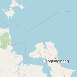
Map view of Berbak National Park

Use this park location map to pinpoint Berbak National Park in Indonesia, understand its exact geographic position, and read its mapped placement within the surrounding landscape more clearly.

Pigeon | © OpenStreetMap contributors

Location context for Berbak National Park

JambiSumatra
Park atlas

Discover more protected wetland ecosystems and diverse conservation landscapes across Indonesia's Sumatra island.

Explore Other National Parks and Protected Areas Near Berbak National Park, Sumatra
Explore a curated list of national parks and other protected areas found near Berbak National Park, encompassing the unique peat swamp forests, vast wetlands, and coastal landscapes of Sumatra and Indonesia. Trace the geographic patterns of conservation efforts across the region, allowing for direct comparison of diverse protected ecosystems and their regional significance.
National parkSumatra

Sembilang National Park: A Mapped Protected Landscape within Sumatra's Geography

Understanding its park boundaries and regional natural context.

Delve into the atlas-level details of Sembilang National Park, a protected national park situated on the island of Sumatra. This exploration focuses on its geographic footprint, mapped boundaries, and its significance as a component of Indonesia's broader protected natural landscapes. Discover how this park contributes to the regional geography and offers a distinct protected-area identity within the Indonesian archipelago.

Area
2,051 km²
Established
2001
IUCN
II
Relief
Lowland
National parkJambi

Bukit Duabelas National Park: Jambi's Protected Lowland Tropical Rainforest Landscape

Explore its mapped terrain and vital water catchment geography.

Bukit Duabelas National Park is a protected area in Jambi, Sumatra, safeguarding critical lowland tropical rainforest ecosystems. Its name reflects the hilly terrain that defines its landscape, acting as an essential water catchment for the Batang Hari River. This park offers an atlas-focused view of Sumatra's threatened forest heritage and its importance within regional geography, including unique timber species and the ancestral lands of the Orang Rimba people.

Area
605 km²
Established
2000
IUCN
II
Relief
Lowland
National parkIndonesia

Bukit Tigapuluh National Park: Protected Area Identity and Indonesian Geographic Context

Explore mapped boundaries and regional landscape features.

Bukit Tigapuluh National Park stands as a protected natural area within Indonesia. This entry provides detailed geographic information, focusing on its mapped extent and its contribution to the nation's conservation atlas. Understanding its place within Indonesia's broader geography highlights the significance of its protected landscape and its role in regional natural resource mapping.

Area
1,432.23 km²
Established
1995
IUCN
II
Relief
Lowland
National parkRiau Province

Tesso Nilo National Park: Exploring Its Protected Landscape and Geographic Identity in Riau Province

Mapped boundaries and regional park atlas context.

Uncover the core identity of Tesso Nilo National Park, a designated national park situated within Riau Province. This entry focuses on its role as a protected landscape, detailing its mapped geographic footprint and offering insights relevant for atlas exploration. Understand how its protected area status contributes to the regional geography and landscape context of Indonesia, providing a focused view for geographic discovery.

Area
1,000 km²
Established
2004
IUCN
II
Relief
Lowland
National parkWest Sumatra

Kerinci Seblat National Park: National Park Protected Landscape in West Sumatra

Explore its mapped geography and regional atlas context.

Kerinci Seblat National Park represents a critical protected area, identified as a national park within Indonesia's West Sumatra province. This page provides a deep dive into its geographic footprint and landscape characteristics, serving as a key entry point for understanding the park's specific context. Users can leverage this detailed information for map-based exploration and to grasp its significance within the larger atlas of protected natural lands, focusing on its distinct geographical identity.

Area
13,750 km²
Established
1999
IUCN
II
Relief
Mountain
National parkLampung

Way Kambas National Park: Mapped Lowland Rainforest and Wetland Ecosystems

Explore the geography and protected landscape of this Indonesian national park.

Way Kambas National Park in Lampung, Indonesia, is a significant protected area characterized by its extensive lowland rainforest and varied wetland habitats. The park's landscape features swamp forests, coastal fringes, and river systems, creating a unique ecological mosaic. It serves as a critical sanctuary for endangered species, offering a vital context for understanding Sumatra's remaining natural landscapes. Explore the mapped boundaries and geographic identity of this important conservation area.

Area
1,300 km²
Established
1989
IUCN
II
Visitors
2.6K annual
National parkSumatra

Bukit Barisan Selatan National Park: Sumatra's Critical Tropical Rainforest Corridor

Explore mapped boundaries and regional geography within this protected area.

Bukit Barisan Selatan National Park is a substantial national park located in Sumatra, Indonesia, designated as a protected landscape along the southern Bukit Barisan mountain range. Spanning a considerable area, it functions as a crucial corridor of tropical rainforest, playing a pivotal role in conservation efforts and the preservation of Sumatra's unique geographic identity. This page serves as a dedicated entry point for understanding the park's protected area status and its mapped presence within the broader regional geography of Indonesia.

Area
3,568 km²
Established
1982
IUCN
II
Relief
Mountain
National parkWest Sumatra

Siberut National Park: Isolated Island Ecosystem and Endemic Wildlife Atlas

Discover the mapped geography and unique landscapes of this West Sumatra protected area.

Siberut National Park in West Sumatra, Indonesia, presents a distinct protected landscape forged by long-term geographic isolation. This national park covers a significant portion of Siberut Island, showcasing a rich tapestry of lowland dipterocarp rainforest, swamp forest, and coastal mangrove ecosystems. Explore its unique terrain, river systems, and protected boundaries to understand the extraordinary concentration of endemic species, particularly its globally significant primate populations.

Area
1,905 km²
Established
1992
IUCN
II
Climate
Tropical

Common questions about visiting, size, designation, and location context for Berbak National Park

Berbak National Park FAQs for park facts, access, geography, and protected area context
Find quick answers about Berbak National Park, including protected-area facts, park geography, trail and visitor context, and how the park fits into its surrounding country and regional landscape.
MoriAtlas Explorer

Continue Your Protected Areas Search Across the Global Atlas

Deepen your exploration by continuing the structured search for national parks and protected areas worldwide. Utilize the comprehensive filtering capabilities to compare different conservation landscapes and refine your understanding of global park geography. Discover more about the distribution and characteristics of protected natural areas.

Global natural geography