

Mori Atlas logo
Protected areaBeung Kiat Ngong Wetlands

Mapping the peatland habitats and seasonal marshes of southern Laos within the Indo-Burma Biodiversity Hotspot

Beung Kiat Ngong Wetlands: A Vital Protected Area and Freshwater Ecosystem in Champassak Province

Beung Kiat Ngong Wetlands represents a crucial protected area in Champassak Province, Laos, serving as a complex mosaic of freshwater lakes, swamps, and tropical peatland ecosystems. This Ramsar-designated site functions as a vital hydrological regulator, while its landscape provides essential habitat for threatened wildlife across a broad catchment area. It exists at the intersection of conservation land and traditional use, anchored by its connection to the adjacent Xe Pian National Protected Area.

wetlandsRamsar sitepeatlandsIndo-Burma Biodiversity Hotspotfreshwater habitatsflooded grasslands

Beung Kiat Ngong Wetlands

Protected area

Park overview

Structured park overview, official facts, and landscape profile for Beung Kiat Ngong Wetlands

Beung Kiat Ngong Wetlands park facts, protected area profile, and essential visitor context

Review the core facts for Beung Kiat Ngong Wetlands, including designation, size, terrain, visitor scale, habitats, and operating context in one park-focused overview.

About Beung Kiat Ngong Wetlands

Beung Kiat Ngong Wetlands is a structured freshwater landscape defined by the interaction of lakes, swamps, peatlands, marshes, and flooded forests in the lowlands of southern Laos. Lying in the Pathoumphone District of Champassak Province, the wetland extends southward from the provincial capital Pakse and forms part of a larger hydrological and ecological system that is tied to the broader Xe Pian drainage and protected area network.

Ecologically, the wetland is exceptional because it combines relatively rare tropical peat substrates with extensive seasonal flooding and a mosaic of vegetation types. Soils enriched by peat and a reliable supply of surface water support dense forest growth, while seasonally inundated grasslands create open habitats that shift in character through the year. This mosaic of conditions gives the site an unusually rich biodiversity profile within Laos, supporting threatened mammal and reptile species as well as a wide range of aquatic and wetland-dependent life.

The protected status of Beung Kiat Ngong rests on its recognition as a Ramsar Wetland of International Importance, designated in 2010, and on its relationship with the Xe Pian National Protected Area, within which most of its southern portion lies. Together these designations place the site within the Central Indochina portion of the Indo-Burma Biodiversity Hotspot, strengthening its broader regional conservation significance.

Equally importantly, the wetland is a living, inhabited landscape. Some 20 villages with a combined population of around 7,400 people fall within or beside the site, and their livelihoods revolve around subsistence and commercial fishing, rice cultivation, harvesting of wild vegetables, and gathering of non-timber forest products. A working population of domesticated elephants remains part of the local landscape, linking contemporary land use to longer traditions of human interaction with the wetland environment.

Quick facts and research context for Beung Kiat Ngong Wetlands

Beung Kiat Ngong Wetlands is a Ramsar-listed wetland complex located in Pathoumphone District, Champassak Province, southern Laos, roughly 56 kilometers south of Pakse. The wetland spans about 2,360 hectares within a broader catchment of more than 6,000 hectares, of which a significant portion falls inside the Xe Pian National Protected Area. It includes roughly 400 hectares of high-quality peatland and around 1,000 hectares of lower-quality seasonal semi-peatland, alongside lakes, swamps, and seasonally flooded grasslands.

The site was designated as a Ramsar Wetland of International Importance on 16 June 2010 under reference number 1941. It sits within the Indo-Burma Biodiversity Hotspot and supports threatened species such as the fishing cat, leopard cat, sambar deer, and Malayan snail-eating turtle. Around 7,400 people live within the wetland boundaries, making the area important for both biodiversity and rural livelihoods.

Protection and recognition

Documented terrestrial protection scope, designation history, and Ramsar records.

Beung Kiat Ngong Wetlands Protection Status and International Recognition

Beung Kiat Ngong Wetlands maintains documented terrestrial protection status established in 2010 alongside official international recognition as a Ramsar site. Structured records outline the designation history and management scope associated with this protected area.

International recognition

Protection details

Protection scope
Terrestrial
Designated year
2010
Transboundary protection
No
Park context

Deeper park guide and search-rich context for Beung Kiat Ngong Wetlands

Beung Kiat Ngong Wetlands history, landscape, wildlife, and travel context

Explore Beung Kiat Ngong Wetlands through its history, landscape character, ecosystems, wildlife, conservation priorities, cultural context, and seasonal travel timing in a structured park guide built for atlas discovery and search intent.

Why Beung Kiat Ngong Wetlands stands out

Beung Kiat Ngong is best known for being one of the very few locations in Laos where peatland ecosystems occur, giving the site a distinctive ecological profile within the country. The combination of high-quality peat soils, seasonal and perennial flooded grasslands, and rich swamp forests creates a hydrological system that supports flood regulation, groundwater recharge, and a notable concentration of threatened wildlife. Within the broader Mekong region, the wetland stands out for its integration of multiple wetland types within a single protected landscape and for its overlap with the Xe Pian National Protected Area, which extends its conservation value well beyond the Ramsar boundary.

Beung Kiat Ngong Wetlands history and protected-area timeline

Beung Kiat Ngong gained international recognition when it was designated as a Ramsar Wetland of International Importance on 16 June 2010, under Ramsar reference number 1941. This listing marked an important step in formally acknowledging the wetland's ecological value at a global scale and placed it within the network of internationally significant wetlands coordinated under the Ramsar Convention.

At a national level, the southern portion of the wetland, along with much of the surrounding landscape, was already encompassed by the Xe Pian National Protected Area, providing a domestic framework for conservation management. Local governance of the site combines the responsibilities of district-level institutions, with the Agriculture and Forestry District Office playing a key role alongside the Water Resources and Environment Agency.

Beyond formal designations, the wetland reflects a long-standing relationship between local communities and the landscape. Villages such as Ban Kiat Ngong have been present here for generations, and traditional uses including fishing, rice cultivation, harvesting of wild plants, and elephant keeping form an ongoing cultural and economic connection to the wetland.

Beung Kiat Ngong Wetlands landscape and geographic character

The landscape of Beung Kiat Ngong is shaped by water and the way it moves across a lowland catchment south of Pakse. The terrain is relatively flat, with a mosaic of open water bodies, permanently waterlogged swamps, seasonally flooded marshes, and forested areas that respond to the rhythm of the monsoon.

Peat substrates are a particularly notable feature of the terrain. Roughly 400 hectares of high-quality peatland are present, alongside about 1,000 hectares of lower-quality seasonal semi-peatland, making this one of the few landscapes in Laos where such formations occur. The interaction of these peat soils with seasonal flooding produces a distinctive hydrological setting characterized by saturated ground, rich organic soils, and luxuriant vegetation.

The wider catchment, extending beyond the core wetland to more than 6,000 hectares, ties the site into the surrounding Xe Pian landscape. Forest patches, grasslands, and the fringes of the Xe Pian National Protected Area create a transitional zone between open wetland and dryland habitats, producing a varied and ecologically layered surface terrain.

Beung Kiat Ngong Wetlands ecosystems, habitats, and plant life

Ecologically, Beung Kiat Ngong is defined by the diversity of wetland types packed into a relatively compact area. Lakes, swamps, peatlands, and seasonal marshes each support their own vegetation communities, ranging from open water and floating plants to dense swamp forest and seasonally inundated grasslands.

The site's peatland component is particularly important. High-quality peat areas, combined with broader semi-peatland expanses, anchor organic-rich soils that support vigorous plant growth and contribute to the exceptional fertility of the surrounding forest patches. Seasonal flooding creates a dynamic habitat pattern, with grasses and water-tolerant vegetation thriving during the wet months and contracting as the dry season advances.

As part of the Indo-Burma Biodiversity Hotspot's Central Indochina zone, the wetland sits within one of the most biodiverse yet threatened regions in Asia. Its combination of permanent water, seasonal fluctuation, peat soils, and forest cover produces a habitat mosaic that sustains a wide variety of aquatic, wetland, and forest-associated species.

Beung Kiat Ngong Wetlands wildlife and species highlights

Beung Kiat Ngong supports a notably rich vertebrate fauna for a single wetland site, with particular importance for several threatened mammal and reptile species. The fishing cat, a wetland-specialist carnivore, is among the most emblematic residents, alongside the leopard cat, another small felid associated with dense habitat mosaics near water.

Larger ungulates such as the sambar deer inhabit the forested and transitional zones of the wetland, indicating the presence of substantial dry-ground cover as well as open marsh. The site is also notable for the presence of the Malayan snail-eating turtle, a freshwater reptile of conservation concern that depends on clean, well-vegetated aquatic habitats.

Beyond these headline species, the diversity of habitat types, from open water to peatland forest, supports a broader community of fish, amphibians, waterbirds, and invertebrates that underpin the wetland's ecological function. The seasonal pulse of flooding and drying likely shapes breeding cycles, feeding opportunities, and movement patterns across the site.

Beung Kiat Ngong Wetlands conservation status and protection priorities

Conservation significance at Beung Kiat Ngong operates on several levels. Internationally, its 2010 designation as a Ramsar Wetland of International Importance brings it into a global framework for the protection and wise use of wetlands, with associated expectations for monitoring and management.

At the regional scale, the wetland overlaps with the Xe Pian National Protected Area, extending its protection regime across the southern portion of the site and into the broader landscape. Its inclusion within the Central Indochina area of the Indo-Burma Biodiversity Hotspot adds another layer of conservation significance, connecting the site to efforts aimed at preserving one of Asia's most threatened biodiversity regions.

The wetland also provides critical ecosystem services. It plays a role in flood control by absorbing and slowing wet-season water, helps maintain groundwater levels during drier months, and supports forest growth through the fertility of its peat soils. These functions reinforce the conservation argument that protecting Beung Kiat Ngong is about safeguarding both biodiversity and important hydrological infrastructure for southern Laos.

Beung Kiat Ngong Wetlands cultural meaning and human context

Beung Kiat Ngong is more than a natural system; it is a landscape inhabited and shaped by several thousand people across roughly 20 villages. Subsistence and commercial fishing, rice cultivation, the harvesting of wild vegetables, and the gathering of non-timber forest products all reflect long-standing patterns of land and water use, with households directly dependent on the wetland's seasonal rhythms.

Cultural landmarks include Phou Asa temple, located on the western side of the wetland, which lends the area a recognized heritage site alongside its ecological importance. The continued presence of domesticated elephants in the area also ties the wetland to traditional practices of elephant keeping, an activity that links current residents to longer regional histories of human-elephant coexistence in the lowlands of southern Laos.

Together, these cultural and livelihood elements make the wetland a working landscape, where conservation objectives and everyday human activity must be understood in relation to one another.

Top sights and standout views in Beung Kiat Ngong Wetlands

Peatland rarity: one of the only places in Laos where tropical peatland habitats occur, including both high-quality peat and seasonal semi-peatland formations.

Wetland diversity: a single site encompassing lakes, permanent swamps, seasonal marshes, and peat-influenced habitats, creating an unusually varied wetland mosaic.

Protected status: designated as a Ramsar Wetland of International Importance in 2010, and partially overlapping the Xe Pian National Protected Area within the Indo-Burma Biodiversity Hotspot.

Threatened species support: documented presence of fishing cat, leopard cat, sambar deer, and Malayan snail-eating turtle.

Hydrological function: significant flood control and groundwater recharge role for the surrounding region in Champassak Province.

Living cultural landscape: home to about 7,400 people across 20 villages, the Phou Asa temple site, and a working population of domesticated elephants.

Best time to visit Beung Kiat Ngong Wetlands

The climate at Beung Kiat Ngong is strongly monsoonal, with a clearly defined wet season from late May through October and a dry season running from late October into early May. Planning a visit around these seasons shapes very different experiences of the landscape.

During the wet season, the wetland expands its footprint as seasonal grasslands and peatland areas become saturated, water levels rise across the catchment, and humidity approaches saturation. This is the period when floodplain dynamics, bird activity, and the full extent of the wetland are most visible, though access can be affected by heavy rains and difficult ground conditions.

The dry season brings lower water levels, falling humidity, and cooler mornings, with January temperatures dipping into the mid-teens Celsius and April producing the hottest conditions at well over 30 degrees Celsius. Average annual rainfall is around 2,000 millimeters, with August often contributing a large share. For visitors interested in combining ecological observation with manageable field conditions, the transitional periods between wet and dry seasons can offer a balance between high water and easier access.

Monthly climate preview

Long-term temperature ranges and monthly precipitation rhythm for Champassak Province

Beung Kiat Ngong Wetlands Climate Normals and Annual Weather Patterns

Representative coordinates record measured annual temperature fluctuations and monthly precipitation variations across the protected landscape. Examining the full twelve-month profile reveals detailed baseline climate normals for comprehensive geographic research.
Annual mean27 °C
25 °C30 °C
Jan25°
Feb27°
Mar29°
Apr30°
May29°
Jun27°
Jul27°
Aug26°
Sep26°
Oct26°
Nov26°
Dec25°
Warmest month
April

30.3 °C

Coolest month
December

24.8 °C

Wettest month
August

9.9 mm/day

Driest month
January

0.2 mm/day

Park location guide

Geography guide, regional context, and park location map for Beung Kiat Ngong Wetlands

Beung Kiat Ngong Wetlands park geography, regions, and map view in Laos

Understand where Beung Kiat Ngong Wetlands sits in Laos through a broader geographic reading of the surrounding landscape, nearby location context, and its mapped position within the national park landscape.

How Beung Kiat Ngong Wetlands fits into Laos

Laos, officially the Lao People's Democratic Republic, is a unitary communist state in mainland Southeast Asia. As the only landlocked country in the region, it shares borders with Myanmar, China, Vietnam, Cambodia, and Thailand. The country has a population of over 7 million and is known for its mountainous terrain, Buddhist heritage, and three UNESCO World Heritage Sites: Luang Prabang, Vat Phou, and the Plain of Jars. The Boten, Vientiane railway completed in 2021 connects Laos to China.

Wider geography shaping Beung Kiat Ngong Wetlands in Laos

Laos is located in mainland Southeast Asia, occupying a mountainous and forested landscape. It is bordered by Myanmar and China to the northwest, Vietnam to the east, Cambodia to the southeast, and Thailand to the west and southwest. As the only landlocked country in Southeast Asia, it has no coastline. The country lies at approximately 17.967°N latitude and 102.6°E longitude.

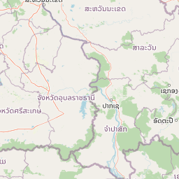
Map view of Beung Kiat Ngong Wetlands

Use this park location map to pinpoint Beung Kiat Ngong Wetlands in Laos, understand its exact geographic position, and read its mapped placement within the surrounding landscape more clearly.

Pigeon | © OpenStreetMap contributors

Location context for Beung Kiat Ngong Wetlands

Champassak Province
Park atlas

Compare regional conservation landscapes and nearby wetland sanctuaries

Explore Protected Areas and Parks Near Beung Kiat Ngong Wetlands

Browse other protected areas and national parks connected to the surrounding region of southern Laos. Compare adjacent lowland habitats and wetland corridors to understand regional biodiversity patterns.
National parkRatanakiri province
About 51 km away#1 closest

Southeast

Virachey National Park: Cambodia's Vast Highland Protected Landscape in Ratanakiri

Explore its remote montane forest ecosystems and diverse terrain.

Virachey National Park, Cambodia's largest national park, offers a profound glimpse into one of mainland Southeast Asia's last great wildernesses. Spanning remote highland terrain in Ratanakiri province, it features dramatic elevation changes from 400 to 1,500 meters, supporting diverse ecosystems including dense lowland forests, unique montane cloud forests, and upland savannahs. Its recognition as an ASEAN Heritage Park underscores its critical regional conservation value, making it a significant destination for understanding protected landscapes and their geographic context.

Area
3,380.57 km²
Established
1993
IUCN
II
Relief
Mountain
National parkUbon Ratchathani Province
About 79 km away#2 closest

West

Phu Chong, Na Yoi National Park: Protected Landscape Exploration in Ubon Ratchathani

Discover the park's mapped boundaries and regional geographic context.

Phu Chong, Na Yoi National Park offers a distinct entry point for exploring protected natural areas in Thailand. As a designated national park within Ubon Ratchathani Province, its geographic features and mapped protected land contribute to a richer understanding of regional landscape patterns. This park provides essential context for atlas-based discovery of Thailand's conservation landscapes.

Area
686 km²
Established
1987
IUCN
II
Visitors
127.4K annual
National parkUbon Ratchathani Province
About 90 km away#3 closest

Northwest

Kaeng Tana National Park: Mapped Protected Landscape in Ubon Ratchathani Province

Explore Thailand's national park geography and boundaries.

Kaeng Tana National Park is a designated national park located in Ubon Ratchathani Province, Thailand. This atlas-focused content helps users understand its unique protected landscape identity and geographic setting. Explore the mapped context of Kaeng Tana National Park, contributing to a structured understanding of conservation areas and natural terrain within Thailand's broader geography.

Area
80 km²
Established
1981
IUCN
II
Visitors
31.2K annual
National parkUbon Ratchathani Province
About 95 km away#4 closest

Northwest

Pha Taem National Park: Mapped Protected Landscape in Ubon Ratchathani

National park exploration and geographic context

Pha Taem National Park serves as a distinct protected area within Ubon Ratchathani Province, offering a focused lens for geographic discovery. Understand its specific location, mapped boundaries, and the surrounding natural landscape context that defines this national park. This entry supports detailed atlas exploration of Thailand's protected territories.

Area
340 km²
Established
1991
IUCN
II
Visitors
180.2K annual
Protected areaSalavan Province
About 104 km away#5 closest

Northwest

Phou Xieng Thong National Protected Area: Geographic Boundaries and Regional Landscape Context

A unique Mekong River protected area in Salavan Province

Phou Xieng Thong National Protected Area defines a unique geographic corridor in southern Laos. Spanning across Salavan and Champasak provinces, the park features a dramatic vertical transition from the Mekong River boundary up to an interior plateau. Its landscape, characterized by sheer cliffs and open rocky flats, serves as an essential ecological bridge and Important Bird Area within the regional conservation network.

Area
1,200 km²
Established
1993
IUCN
VI
Relief
Upland
National parkRatanakiri province
About 106 km away#6 closest

Southeast

Veun Sai, Siem Pang National Park: Northeastern Cambodia's Protected Lowland Forest Landscape

Mapped Boundaries and Primate Conservation Habitat

Veun Sai, Siem Pang National Park in Cambodia's Ratanakiri province is a vital protected area featuring expansive lowland evergreen and semi-evergreen forests. Its designation as a national park underscores its role in safeguarding critical habitat for diverse primate populations, notably the endangered Northern buffed-cheeked gibbon. The park's geography, characterized by gentle terrain and extensive forest cover, makes it a significant component of the region's biodiversity corridor and a key site for understanding Cambodia's natural landscapes.

Area
574.69 km²
Established
2016
IUCN
II
Relief
Lowland
National parkSisaket Province
About 150 km away#7 closest

West

Khao Phra Wihan National Park: Protected Landscape and Archaeological Atlas Gateway

Explore dramatic red sandstone cliffs and historic Khmer ruins.

Khao Phra Wihan National Park in Sisaket Province, Thailand, is a protected landscape distinguished by its dramatic Pha Mo I Daeng red sandstone cliff and its role as a gateway to significant Khmer archaeological sites. This national park offers a deep dive into the region's unique geography, featuring rugged terrain, distinctive forest ecosystems, and prehistoric rock art. As a key entry point for understanding the Preah Vihear Temple's context, the park provides rich material for atlas-based exploration of border landscapes and historical terrain.

Area
130 km²
Established
1998
IUCN
II
Visitors
202.6K annual
National parkKon Tum Province
About 155 km away#8 closest

East

Chư Mom Ray National Park: A Mapped Protected Landscape in Kon Tum Province, Vietnam

Explore National Park Geography and Protected Boundaries

Chư Mom Ray National Park is a vital national park located in Vietnam's Kon Tum Province. This page offers an atlas-style exploration of its protected landscape, detailing its geographic setting and mapped boundaries. Discover how Chư Mom Ray National Park fits into the regional geography of Vietnam and understand its significance as a distinct conservation area within the broader landscape.

Area
566.21 km²
Established
2002
IUCN
II
Access
Access unknown

Common questions about visiting, size, designation, and location context for Beung Kiat Ngong Wetlands

Beung Kiat Ngong Wetlands FAQs for park facts, access, geography, and protected area context

Find quick answers about Beung Kiat Ngong Wetlands, including protected-area facts, park geography, trail and visitor context, and how the park fits into its surrounding country and regional landscape.
MoriAtlas Explorer

Continue Your Protected Areas Search Across the Global Atlas

Deepen your exploration by continuing the structured search for national parks and protected areas worldwide. Utilize the comprehensive filtering capabilities to compare different conservation landscapes and refine your understanding of global park geography. Discover more about the distribution and characteristics of protected natural areas.

Global natural geography

