Peaks
Núi Chư Yan Kao
1,949 m

Analyzing the terrain, elevation extremes, and mountain landscape of this protected area.
This geographic profile details the physical characteristics of Bidoup Nui Ba National Park within Lâm Đồng Province. The structured data includes a recorded area of 648 square kilometers, a maximum elevation reaching 2287 meters, and various mountain peaks, reservoirs, and rivers located within the park boundary.
Related tags
Vietnam's highland conservation stronghold protecting the Langbiang plateau's ancient conifer forests and endangered wildlife
Bidoup Nui Ba National Park is a protected highland area in the Central Highlands of Vietnam, spanning portions of Đam Rông and Lạc Dương districts within Lâm Đồng Province. Established in 2004 and named after the two highest peaks of the Langbiang plateau, Bidoup (2,287 meters) and Nui Ba (2,167 meters), the park encompasses approximately 64,800 hectares, making it one of the five largest national parks in Vietnam. The park occupies a strategic position on the Langbiang plateau, a mountainous region that rises dramatically from the surrounding lowlands and is often referred to as the roof of the Central Highlands.
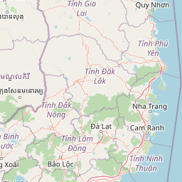
Regional placement within Lâm Đồng Province and Tây Nguyên
Analyzing the 648 square kilometer protected expanse and coordinate limits
Mountain relief range spanning recorded peaks, rivers, and streams
Peaks
1,949 m
Peaks
2,038 m
Rivers
Viewpoints
Peaks
2,167 m
Peaks
2,287 m
Analysis of recorded montane relief, tropical climate zones, and forest cover
Mountains · Forest · Woodland · Grassland
Temperate broadleaf forest · Temperate coniferous forest · Montane forest · Alpine meadow · Grassland
Trace the regional park geography and compare protected landscapes within Vietnam's Central Highlands, extending your discovery from Bidoup Nui Ba.
Southeast

Explore Vietnam's Phước Bình National Park and its mapped terrain.
Phước Bình National Park represents a distinct national park entity situated within Ninh Thuận Province, Vietnam. This destination facilitates an atlas-driven understanding of its protected landscape, emphasizing its geographical placement and mapped boundaries. Explore the core identity of this park as a component of Vietnam's protected areas network and its specific regional landscape context.
Southwest
Mapped Boundaries and Regional Terrain Context
Tà Đùng National Park represents a vital protected landscape within Vietnam's Đắk Nông Province, offering rich opportunities for geographic discovery. This entry details the park's identity as a national park, focusing on its mapped boundaries and its contribution to the regional atlas. Explore the fundamental geographic features and protected land context that define Tà Đùng National Park, facilitating a deeper understanding of its place within the broader natural landscape.
Southeast
Explore Ninh Thuận Province's national park geography.
Núi Chúa National Park is a key protected area within Vietnam's Ninh Thuận Province, offering vital context for understanding regional geography and mapped natural landscapes. This entry provides the essential geographic details for the park, serving as a foundational element for atlas-based discovery of Vietnam's protected lands. Delve into its mapped boundaries and landscape identity to appreciate its significance.

North
Explore its protected boundaries and regional geographic context.
Chư Yang Sin National Park stands as a key protected natural area within Vietnam's Central Highlands. This national park, located in the expansive Đắk Lắk Province, provides a rich subject for geographic discovery. Understanding its mapped boundaries and position within the regional landscape offers valuable context for atlas-based exploration of Vietnam's protected lands.
Northwest
Mapped boundaries within Đắk Lắk Province, part of a transboundary conservation area.
Yok Đôn National Park is Vietnam's largest lowland forest national park, covering approximately 1,155 square kilometers in Đắk Lắk Province. This protected area is characterized by its rare khộp forest ecosystem and serves as a crucial refuge for large mammals. Situated near the Cambodian border, it forms a key component of one of Southeast Asia's largest continuous protected area networks, offering significant insights into regional protected landscape geography and conservation connectivity.
Southwest
Explore the mapped boundaries and diverse ecosystems of this vital national park.
Cát Tiên National Park represents a significant ecological reserve in southern Vietnam, covering a vast expanse of lowland tropical forest and critical wetland habitats. The park's landscape is shaped by seasonal flooding from the Dong Nai River, creating unique ecosystems like the renowned Bàu Sấu (Crocodile Lake) and supporting diverse flora and fauna. Understanding Cát Tiên National Park's geography, its protected landscape character, and its position within Vietnam offers valuable insights for atlas-based exploration of Southeast Asia's natural heritage.
West
Discover its mapped boundaries and terrain in Bình Phước Province.
Bù Gia Mập National Park is a designated national park in Vietnam, located within the geographical area historically associated with Bình Phước Province. This page focuses on providing a structured understanding of the park's protected land status and its mapped geographic features. Explore the context of this protected landscape, its position within the regional geography, and its role as an element for atlas-based discovery of Vietnam's natural areas.
Northwest

Explore mapped boundaries and regional landscape context.
O'Yadav National Park is a national park located in northeastern Cambodia's Ratanakiri province, designated to protect significant forest ecosystems and serve as a vital link in the nation's biodiversity corridor system. Spanning 105,019 hectares, the park encompasses forested terrain and includes the historically significant Yak Nang temple site. Its conservation efforts contribute to the ecological integrity of the broader Indochinese region, making it a key protected landscape for atlas-based geographic study.
Deepen your understanding of Bidoup Nui Ba National Park by examining its precise geographic placement and the extent of its protected landscape. This national park entry provides critical data for atlas exploration, enabling detailed study of its mapped boundaries and its role within the broader regional geography of Vietnam's Central Highlands.