Mori Atlas logo
National parkBournda National Park

Discover the mapped boundaries and protected landscape identity of Bournda National Park.

Bournda National Park: National Park, New South Wales, Australia Geographic and Landscape Context

Bournda National Park stands as a significant protected national park within the diverse geography of New South Wales, Australia. This dedicated atlas entry provides essential geographic context, allowing for detailed exploration of its mapped boundaries and the unique characteristics of its protected landscape. Understand Bournda National Park's place within the regional context of New South Wales and its importance as a distinct natural area for geographic discovery.

Coastal national parksLagoons and lakesImportant Bird AreasSwift parrot habitatSouth Coast NSWWalking tracks
Coastal landscape illustration showing rocky cliffs, ocean waves, and green vegetation

Bournda National Park

National park

Park overview

Structured park overview, official facts, and landscape profile for Bournda National Park

Bournda National Park park facts, protected area profile, and essential visitor context
Review the core facts for Bournda National Park, including designation, size, terrain, visitor scale, habitats, and operating context in one park-focused overview.

About Bournda National Park

Bournda National Park occupies a striking position on the South Coast of New South Wales, where the temperate rainforest and eucalyptus forests of the hinterland meet the Pacific Ocean. The park's landscape is defined by its sequence of coastal water bodies, each with distinct ecological characteristics. Wallagoot Lake, the largest of these, is a barrier lake that historically opens to the ocean during significant storm events, with its last opening occurring in June 2008. Bondi Lake holds particular ecological significance as the closest freshwater lake to the ocean in the Far South Coast region, supporting unique aquatic communities adapted to the transition between freshwater and brackish conditions. Bournda Lagoon, situated between these two bodies of water, offers accessible swimming opportunities and forms the nucleus of the park's camping facilities at Hobart Beach. The park's coastline features rocky headlands, sandy beaches, and the distinctive Bournda Island, which can be explored via a 6-kilometre walking loop. The vegetation across the park ranges from coastal heath on the more exposed slopes to tall eucalyptus forest in the protected valleys, creating a mosaic of habitats that supports considerable biodiversity.

Quick facts and research context for Bournda National Park

Bournda National Park is located near the coastal town of Tathra on the Far South Coast of New South Wales. The park covers 2,655 hectares and features three distinct water bodies: Wallagoot Lake (saltwater), Bondi Lake (freshwater), and Bournda Lagoon (brackish). Managed by the NSW National Parks and Wildlife Service, the park contains over 20 kilometres of walking tracks including the Kangarutha Track running from Hobart Beach to Tathra. The adjacent Bournda Nature Reserve, established in 1972, adds 6,088 hectares of additional protected land to the area.

Park context

Deeper park guide and search-rich context for Bournda National Park

Bournda National Park history, landscape, wildlife, and travel context
Explore Bournda National Park through its history, landscape character, ecosystems, wildlife, conservation priorities, cultural context, and seasonal travel timing in a structured park guide built for atlas discovery and search intent.

Why Bournda National Park stands out

Bournda National Park is best known for its diverse coastal water systems and its status as part of a nationally significant bird area. The park provides critical habitat for the swift parrot, a vulnerable species that migrates to the region from Tasmania. The combination of saltwater lake, freshwater lake, and brackish lagoon within a single protected area makes Bournda distinctive among coastal parks in New South Wales. The Kangarutha Track, a 12-kilometre coastal walking trail, is also a notable feature for visitors seeking to explore the park's scenic shoreline.

Coastal cliffs and ocean with green vegetation, viewed from above Kianinny Bay
Aerial view of Bournda National Park's coastal cliffs and Kianinny Bay

Bournda National Park history and protected-area timeline

Bournda National Park was formally established as a national park on 24 April 1992, transitioning from its previous designation as a State Recreation Area. This elevation in protection status reflected growing recognition of the area's ecological significance, particularly its coastal lake systems and the habitat they provide for migratory bird species. The adjacent Bournda Nature Reserve, covering 6,088 hectares, was established in 1972 and is managed in conjunction with the national park under a unified management plan developed by the NSW National Parks and Wildlife Service. The park's proximity to Tathra, a small coastal town established in the mid-nineteenth century, has shaped its recreational use and visitor access patterns over many decades. The walking track network, including the long-distance Kangarutha Track, represents decades of trail development that has made the park accessible to visitors seeking to experience its coastal landscapes.

Bournda National Park landscape and geographic character

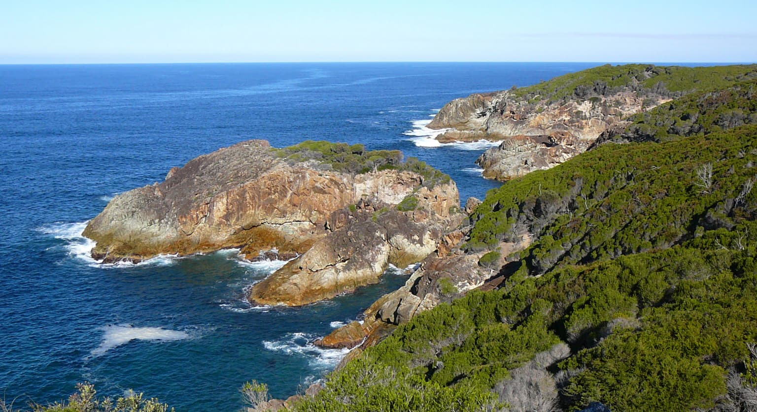
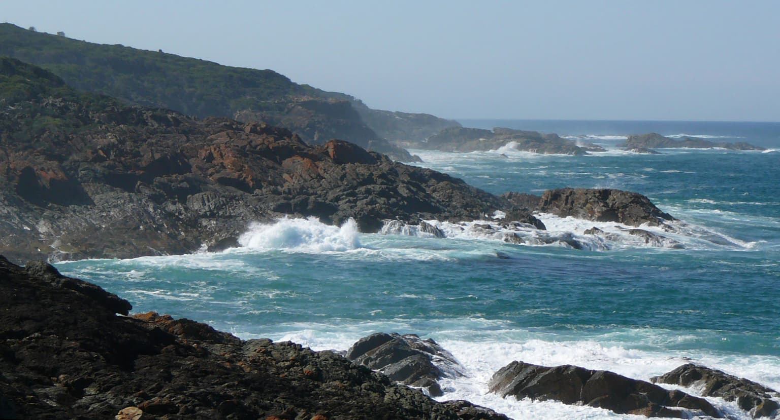
The landscape of Bournda National Park presents a characteristic South Coast sequence of coastal lagoons, barrier beaches, and forested headlands. The park's three primary water bodies each represent different stages in the coastal lake lifecycle. Wallagoot Lake occupies a classic barrier lagoon position, separated from the ocean by a narrow sand barrier that is periodically breached during high seas or flood events. Bondi Lake sits further inland in a fresh water catchment position, receiving flow from small streams that drain the surrounding eucalyptus forested hills. Bournda Lagoon occupies an intermediate position, its brackish waters reflecting the periodic influence of ocean overwash during high tides or storm openings. The park's coastline ranges from the sheltered sandy beach at Hobart Beach through rocky platforms and cliffs to the more exposed southern shores near Bournda Island. The hinterland rises gently from the coast, with the vegetation transitioning from coastal scrub and heath through to tall open forest dominated by spotted gum and Sydney blue gum on the more fertile valley floors.

Rocky coastline with waves crashing against cliffs under a clear sky
Rocky coastline with waves crashing against cliffs in Bournda National Park

Bournda National Park ecosystems, habitats, and plant life

The ecological character of Bournda National Park is defined by the interplay between its coastal water bodies and the surrounding forested landscapes. The park lies within the Far South Coast bioregion, an area known for its high rainfall and lush vegetation. The combination of freshwater, brackish, and saltwater habitats within a relatively compact area creates exceptional ecological diversity. Wallagoot Lake supports marine and estuarine species when open to the ocean, while Bondi Lake provides habitat for freshwater fish and aquatic birds. The coastal heath communities on the well-drained slopes support a different suite of species adapted to more xeric conditions, including numerous wildflower species that bloom seasonally. The tall forests of the deeper valleys and lower slopes provide habitat for arboreal mammals and forest birds, creating a vertical dimension to the park's ecological value.

Bournda National Park wildlife and species highlights

Bournda National Park is recognised as a nationally significant area for bird conservation, forming part of the Ulladulla to Merimbula Important Bird Area identified by BirdLife International. The park provides crucial foraging and breeding habitat for the swift parrot, a vulnerable species that migrates annually from its Tasmanian breeding grounds to the mainland Australian coast. The diverse water bodies within the park support a range of waterbird species, with the freshwater and brackish habitats attracting different bird communities at different times of year. The coastal heath and forest habitats provide nesting and foraging resources for a variety of forest bird species, while the shoreline and island habitats support seabird and shorebird populations. The park's proximity to the ocean also brings regular sightings of dolphins and occasional whale sightings during migration seasons.

Bournda National Park conservation status and protection priorities

The inclusion of Bournda National Park within the Ulladulla to Merimbula Important Bird Area reflects the site's national significance for the conservation of threatened bird species, particularly the swift parrot. This designation recognises that the coastal strip between Ulladulla and Merimbula provides critical winter foraging habitat for swift parrots that have migrated from Tasmania. The park's management, overseen by the NSW National Parks and Wildlife Service, works to maintain the ecological integrity of the park's water bodies, vegetation communities, and wildlife populations. The adjacency of Bournda Nature Reserve, established in 1972, creates a larger contiguous protected area that enhances the conservation value of the broader landscape. The management plan for the area addresses issues including fire management, invasive species control, and visitor impact mitigation to ensure the long-term protection of the park's natural values.

Bournda National Park cultural meaning and human context

The Bournda area has historical connections to local Aboriginal communities, though detailed documentation of indigenous land use specific to the park is limited in the available source material. The coastal lagoon systems and abundant bird and fish resources would have provided traditional food sources for Aboriginal peoples, as they do for contemporary recreational users. The township of Tathra, which borders the park to the north, developed as a small port and fishing community in the mid-nineteenth century, with European settlement predating the park's establishment by over a century. The park's name reflects the broader regional identity of the South Coast, where the interaction between coastal communities and the marine environment has shaped local culture and economy.

Top sights and standout views in Bournda National Park

The 12-kilometre Kangarutha Track from Hobart Beach to Tathra stands as the park's premier walking experience, traversing the full length of the coastline and offering panoramic views of the Pacific Ocean and the park's diverse coastal landscapes. Bournda Lagoon provides accessible swimming in a sheltered setting, complemented by the nearby Hobart Beach camp ground with its good facilities. The circuit walk to Bournda Island, a 6-kilometre loop, allows visitors to explore the island's coastal heath and observe seabird nesting activity. The sequence of three distinct water bodies within a single park offers unique opportunities to observe different aquatic environments and the species they support.

Best time to visit Bournda National Park

The park can be visited throughout the year, with each season offering different advantages. Summer months bring warm conditions ideal for swimming at Bournda Lagoon and camping at Hobart Beach, though this is also the peak visitor period. Autumn and spring offer comfortable temperatures for walking and the opportunity to observe migratory bird species, including swift parrots that arrive on the mainland during the winter months. Winter visits provide a quieter experience with fewer visitors and the chance to see whales migrating along the coast, though swimming conditions are less suitable. The walking tracks are generally accessible year-round, though visitors should check current conditions during periods of high rainfall that may affect some trails.

Park location guide

Geography guide, regional context, and park location map for Bournda National Park

Bournda National Park park geography, regions, and map view in Australia
Understand where Bournda National Park sits in Australia through a broader geographic reading of the surrounding landscape, nearby location context, and its mapped position within the national park landscape.

How Bournda National Park fits into Australia

Australia is a constitutional monarchy and federal parliamentary democracy comprising six states and ten territories. With a population of nearly 28 million, it is one of the world's most urbanised countries, with most people concentrated on the eastern seaboard. The country has a high Human Development Index and is known for its cultural diversity, ancient Aboriginal heritage, and unique wildlife.

Wider geography shaping Bournda National Park in Australia

Australia occupies the entire Australian continent, the island of Tasmania, and numerous smaller islands. It is the world's flattest and driest inhabited continent, featuring vast deserts in the interior (the Outback), tropical rainforests along the eastern coast, and a coastline bordering the Indian and Pacific Oceans.

Map view of Bournda National Park

Use this park location map to pinpoint Bournda National Park in Australia, understand its exact geographic position, and read its mapped placement within the surrounding landscape more clearly.

Pigeon | © OpenStreetMap contributors

Location context for Bournda National Park

New South Wales

A Visual Atlas to Bournda's Unique Coastal Scenery, Lagoon Systems, and Protected Environments in New South Wales

Bournda National Park Photos: Explore Coastal Landscapes, Lakes, and Habitats
Browse a curated collection of imagery to visually understand the diverse landscapes and unique protected-area character of Bournda National Park. These photos showcase its distinct coastal lagoons, barrier beaches, and forested headlands, providing essential context for its varied habitats, scenic terrain, and conservation significance along the New South Wales coast.

Coastal cliffs and ocean with green vegetation, viewed from above Kianinny Bay

Coastal landscape with Bournda Island in the ocean, surrounded by green vegetation and a dirt path.

Rocky coastline with waves crashing against cliffs under a clear sky

Park atlas

Explore mapped geography and conservation landscapes across the South Coast of New South Wales, comparing protected areas adjacent to Bournda National Park.

Discover Other Coastal National Parks and Protected Areas Near Bournda National Park
After exploring Bournda National Park's unique coastal lagoons and diverse habitats, trace its regional context by browsing other protected areas on the New South Wales South Coast. Compare adjacent national parks and significant conservation landscapes to understand the broader network of natural protection in this distinct Australian coastal zone.
Watercolor illustration showing a landscape with green trees, rolling hills, and a path
National parkNew South Wales

Biamanga National Park: Protected National Park with Volcanic Landscape & Regional Geography

Discover mapped terrain and natural park boundaries.

Biamanga National Park is a significant protected area in New South Wales, Australia, notable for its volcanic mountain landscape dominated by Mumbulla Mountain. This national park provides valuable context for understanding regional geography, offering insights into its unique terrain, granite formations, and creek systems. Explore its protected boundaries and the ecological significance of this distinct natural landscape.

Area
137.49 km²
Established
1994
IUCN
II
Relief
Mountain
National parkNew South Wales

Wallaga Lake National Park: National Park Geography and Mapped Boundaries

Discover its protected landscape within New South Wales.

Wallaga Lake National Park is cataloged as a national park within New South Wales, offering a distinct focus for atlas-based geographic discovery. Users can explore its specific location, mapped protected area, and the surrounding natural landscape context. This entry provides a foundational understanding of the park's geographic identity and its significance as part of Australia's protected lands.

Area
12.37 km²
Established
1972
IUCN
II
Climate
Temperate
National parkNew South Wales

Kooraban National Park: Protected Area Map and Landscape Geography in New South Wales

Explore critical marsupial habitat and transitional terrain.

Kooraban National Park in New South Wales is a protected national park recognized for its role in conserving vulnerable marsupial species and its distinctive transitional landscape. Spanning over 11,500 hectares, the park connects inland tableland environments with coastal ecosystems, defined by the Narira Creek valley and Tuross River system. Its geography supports four distinct vegetation communities, making it a vital area for endangered animal habitats and broader conservation efforts within southeastern Australia. This park provides essential context for understanding regional geography and protected-area networks.

Area
116.26 km²
Established
2001
IUCN
II
Relief
Mixed relief
National parkNew South Wales

Gulaga National Park: Mapped Protected Area and Geographic Context in New South Wales

Explore New South Wales's significant national park boundaries.

Gulaga National Park stands as a key protected area within the diverse geography of New South Wales, Australia. This page offers focused insights into the park's mapped landscape, its protected-area designation as a national park, and its specific regional context. Utilize this information for detailed atlas-based exploration of Australia's natural heritage.

Area
46.73 km²
Established
2001
IUCN
II
Relief
Mountain
National parkNew South Wales

Mimosa Rocks National Park: Coastal Protected Area Atlas and Geographic Discovery

New South Wales National Park with Mapped Coastal Terrain

Mimosa Rocks National Park offers a compelling glimpse into Australia's protected coastal geography. This national park showcases a dynamic landscape where rocky outcrops and sweeping beaches define the Sapphire Coastline within New South Wales. Engage with its mapped boundaries and understand its role as a vital part of the regional protected area network, perfect for detailed atlas exploration and appreciating natural landscape context.

Area
57 km²
Established
1973
IUCN
II
Relief
Lowland
National parkNew South Wales

Wadbilliga National Park: Exploring New South Wales' Rugged Protected Landscape

Discover its mapped terrain and diverse ecosystem geography.

Wadbilliga National Park in New South Wales is a prime example of a large, remote protected area characterized by its rugged natural terrain and diverse ecosystems. Spanning approximately 985 square kilometres, the park features dramatic geographic contrasts, from deep gorges carved by rivers like the Tuross to expansive plateaus and sheltered gullies supporting varied vegetation communities. Its designation as a national park underscores its importance for conservation and provides a unique opportunity for understanding the mapped landscape context of southeastern Australia.

Area
985.3 km²
Established
1979
IUCN
Ib
Relief
Mountain
Watercolor painting showing green hills, valleys, and distant mountains
National parkNew South Wales

Eurobodalla National Park: New South Wales Coastal Protected Landscape and Geographic Atlas

Explore its mapped protected boundaries and unique estuarine wetland habitats.

Eurobodalla National Park represents a critical segment of the New South Wales coastline, distinguished by its designation as a national park. The park's geography is characterized by a mosaic of coastal terrains, including sandy shores, river estuaries, and vegetated headlands, which collectively form essential protected landscapes. It is particularly recognized for its role in supporting migratory bird populations and serves as a key site for understanding coastal ecology and conservation efforts within Australia. Through its mapped protected areas, Eurobodalla National Park provides valuable insights into the regional geography and the distribution of vital natural habitats.

Area
29.13 km²
Established
1995
IUCN
II
Relief
Lowland
National parkNew South Wales

Deua National Park: New South Wales National Park Exploration and Map Context

Discover protected landscape boundaries and regional geography.

Deua National Park offers a focused lens into Australia's protected areas, specifically within the state of New South Wales. This page provides detailed geographic context, enabling users to trace the park's boundaries and understand its position within the regional atlas. Explore the mapped terrain and the protected landscape identity that defines Deua National Park as a key component of conservation efforts in the area, ideal for a structured understanding of protected natural spaces.

Area
1,220 km²
Established
1979
IUCN
Ib
Relief
Mountain

Common questions about visiting, size, designation, and location context for Bournda National Park

Bournda National Park FAQs for park facts, access, geography, and protected area context
Find quick answers about Bournda National Park, including protected-area facts, park geography, trail and visitor context, and how the park fits into its surrounding country and regional landscape.
MoriAtlas Explorer

Continue Your Protected Areas Search Across the Global Atlas

Deepen your exploration by continuing the structured search for national parks and protected areas worldwide. Utilize the comprehensive filtering capabilities to compare different conservation landscapes and refine your understanding of global park geography. Discover more about the distribution and characteristics of protected natural areas.

Global natural geography