

Mori Atlas logo
National parkBroad Sound Islands National Park

Mapping the protected boundaries and geographic context of this Queensland national park.

Broad Sound Islands National Park: Queensland's Protected National Park Landscape

Broad Sound Islands National Park represents a key protected area within Queensland, Australia. As a designated national park, its distinct geographic scope and natural landscape features offer valuable context for atlas-driven exploration. This entry facilitates understanding the park's spatial identity, its mapped presence within the Queensland region, and its contribution to the broader understanding of protected lands.

Marine Turtle NestingIsland National ParkCoastal Protected AreaQueensland IslandsFlatback Turtle HabitatRemote Island Chain

Broad Sound Islands National Park

National park

Park overview

Structured park overview, official facts, and landscape profile for Broad Sound Islands National Park

Broad Sound Islands National Park park facts, protected area profile, and essential visitor context
Review the core facts for Broad Sound Islands National Park, including designation, size, terrain, visitor scale, habitats, and operating context in one park-focused overview.

About Broad Sound Islands National Park

Broad Sound Islands National Park protects a distinctive coastal island chain along Queensland's central Capricorn Coast. The archipelago extends across a significant stretch of the Northumberland Islands, with islands ranging from small sand cays to larger vegetated landforms. Flock Pigeon Island marks the easternmost extent near the mainland settlement of Clairview, while High Peak Island represents the western boundary as the most distant island from any port facility.

The park's geographic isolation has been a defining factor in maintaining its ecological integrity. Unlike many coastal areas along the Queensland coast that have experienced development pressure, these islands have remained largely in their natural state. This preservation has allowed traditional ecological processes to continue, particularly those associated with marine turtle nesting cycles that have occurred on these shores for millennia.

The islands feature coastal vegetation communities typical of low-lying Queensland cays and islands, including beach vine thickets, grassland areas, and mangrove fringes in sheltered coastal sections. The marine environment surrounding the islands encompasses productive fishing grounds and supports diverse coastal and pelagic species. Water temperatures in the region support tropical and subtropical marine life, contributing to the broader ecological significance of the area within the Great Barrier Reef marine park network.

Access to the islands is limited by their remote location, which itself contributes to their conservation value. The absence of regular tourism infrastructure helps maintain the wild character of the archipelago and reduces pressure on sensitive nesting areas. Management by Queensland Parks and Wildlife Service focuses on monitoring turtle nesting activity, protecting beach habitats, and maintaining the natural processes that sustain the island ecosystem.

Quick facts and research context for Broad Sound Islands National Park

Broad Sound Islands National Park is located in central Queensland, Australia, approximately 709 kilometers northwest of Brisbane. The protected area encompasses 48 islands within the Northumberland Islands chain, covering roughly 16 square kilometers. The islands feature a low-lying coastal profile with an average elevation of 59 meters above sea level. The climate is subtropical, with average summer temperatures around 30 degrees Celsius and winter temperatures near 23 degrees Celsius. The park is governed by the Queensland Parks and Wildlife Service and holds IUCN category II protected area status. Four islands bear the specific designation of Broad Sound Islands: Long, Tern, Quail, and Wild Duck Islands.

Park context

Deeper park guide and search-rich context for Broad Sound Islands National Park

Broad Sound Islands National Park history, landscape, wildlife, and travel context
Explore Broad Sound Islands National Park through its history, landscape character, ecosystems, wildlife, conservation priorities, cultural context, and seasonal travel timing in a structured park guide built for atlas discovery and search intent.

Why Broad Sound Islands National Park stands out

The Broad Sound Islands are best known as a vital nesting ground for endangered flatback turtles, a species endemic to Australian waters. The remote and relatively undisturbed nature of these coastal islands provides critical habitat for one of the nation's most threatened marine reptiles. Flatback turtles nest specifically on the sandy shores of these islands, with the protection afforded by the national park designation helping to safeguard breeding sites from development pressure and human disturbance. The park represents one of the more significant turtle nesting concentrations in Queensland's island archipelago system.

Broad Sound Islands National Park history and protected-area timeline

The establishment of Broad Sound Islands National Park reflects Queensland's broader expansion of protected areas during the late twentieth and early twenty-first centuries. While the islands had long been recognized for their ecological significance, formal national park designation provided the highest level of protection under Queensland conservation legislation. The park was created to preserve both the terrestrial island environments and the adjacent marine waters that together constitute a coherent ecological unit.

Prior to national park status, the islands existed within a landscape with limited formal protection, though their remoteness provided a degree of natural safeguarding. The recognition of flatback turtle nesting populations as requiring active protection contributed to the case for national park designation. Conservation advocacy during the 1990s and early 2000s highlighted the importance of Queensland's island beaches as turtle nesting habitat, supporting the formal protection of this archipelago.

The park's management under Queensland Parks and Wildlife Service has built upon earlier conservation work in the region, integrating the islands into broader marine and coastal conservation planning for the Capricorn Coast area.

Broad Sound Islands National Park landscape and geographic character

The Broad Sound Islands present a landscape characterized by low-lying coastal terrain, sandy beaches, and coastal vegetation systems. The islands vary in size and formation, with some consisting of small sand and coral cay formations while others are larger landmasses with more established vegetation. Beach profiles range from wide sandy shores suitable for turtle nesting to more rocky sections where coral influence is evident.

The archipelago sits within Broad Sound, a large coastal indentation in Queensland's central coastline. The sound itself is defined by the complex interplay of tidal flows, river sediment from inland catchments, and coral reef formations along the broader coast. Islands within the park are distributed across this marine environment, creating a scattered protected landscape that extends from near the mainland shore outward into the Pacific Ocean.

Elevation across the islands is uniformly low, consistent with their formation as coastal islands rather than mountainous terrain. The average altitude of 59 meters reflects the generally flat to gently undulating terrain of the island chain. Coastal dunes and beach ridges mark the more exposed shores, while sheltered inlets feature mangrove communities and tidal wetlands. The visual character is one of open coastal scenery with distant views across water channels between islands.

Broad Sound Islands National Park ecosystems, habitats, and plant life

The nature of Broad Sound Islands centers on the intersection of terrestrial island habitats with productive marine environments. The island vegetation includes coastal grassland communities, shrubland associations adapted to salt exposure and periodic inundation, and more dense vegetation in areas sheltered from direct coastal winds. These plant communities provide habitat for resident bird species and offer shelter for nesting marine turtles.

The marine environment surrounding the islands is part of the broader Great Barrier Reef ecosystem, though the specific waters of Broad Sound represent a more estuarine-influenced zone where freshwater runoff from coastal rivers mixes with oceanic conditions. This mixing creates productive conditions for fish, crustaceans, and other marine life that support the broader coastal food web. Seagrass beds occur in shallower protected areas, providing additional habitat and food sources for marine species.

Flatback turtles represent the most ecologically significant species associated with the park. Unlike other sea turtle species that may nest across wider geographic ranges, flatback turtles exhibit strong fidelity to specific nesting beaches, with the Broad Sound islands serving as important sites for this behavior. The species nests primarily on sandy beaches during the warmer months, with hatchlings emerging and making their way to the water in a process that has continued on these shores for countless generations.

Broad Sound Islands National Park wildlife and species highlights

The wildlife of Broad Sound Islands National Park is defined primarily by its significance as a nesting ground for flatback turtles. This endangered species relies on the park's beaches for successful reproduction, with female turtles returning to the same general areas where they hatched to lay their eggs. The nesting season brings significant activity to island beaches, with individuals arriving under cover of darkness to excavate nests in the sand above the high-tide mark.

Hatchling success on these islands contributes to broader population dynamics for flatback turtles across their range. The species is endemic to Australian waters, breeding primarily along the northern and eastern coastlines of the continent. Protected beaches such as those within Broad Sound Islands provide crucial habitat for maintaining viable breeding populations. The national park designation helps ensure that nesting beaches remain undisturbed during critical periods.

Beyond marine turtles, the islands support birdlife including seabirds that nest in coastal vegetation and shorebirds that utilize beach areas. Mangrove communities around island margins provide habitat for fish, crabs, and other estuarine species. The productive marine waters support dolphin and porpoise populations that are occasionally observed in the channels between islands.

Broad Sound Islands National Park conservation status and protection priorities

Broad Sound Islands National Park serves an important conservation function as a protected area specifically designed to preserve turtle nesting habitat and the broader island ecosystem. The endangered status of flatback turtles elevates the significance of these islands within Queensland's protected area network. Conservation efforts focus on maintaining the integrity of nesting beaches, protecting dune vegetation, and minimizing disturbance to breeding turtles.

The park contributes to broader marine conservation objectives in the Great Barrier Reef region by protecting island ecosystems that are interconnected with reef environments. Water quality in Broad Sound, sediment management, and coastal development considerations all intersect with the park's conservation mandate. Management practices aim to preserve natural processes rather than actively intervene, allowing ecological systems to function with minimal human interference.

The national park designation provides legal protection that prevents development that might otherwise occur on these coastal islands. This protection extends to both terrestrial and marine components of the park, creating a comprehensive conservation framework for the archipelago.

Broad Sound Islands National Park cultural meaning and human context

The Broad Sound Islands exist within the traditional country of Aboriginal peoples with connections to the central Queensland coast. The islands and surrounding waters would have been part of seasonal movement patterns for coastal Indigenous communities, with marine resources providing food and cultural significance. While specific cultural associations with individual islands may not be well documented in available sources, the broader region holds deep Indigenous heritage value.

European exploration and settlement of the Queensland coast brought attention to the islands as navigational features and later as potential resource areas. The naming of islands such as Flock Pigeon Island and High Peak Island reflects this colonial period of exploration and mapping. Contemporary management of the park occurs within a framework that increasingly recognizes the importance of Indigenous engagement in conservation planning, though detailed cultural heritage assessments for individual islands within the park would be a matter for on-ground management processes.

Top sights and standout views in Broad Sound Islands National Park

The most notable highlight of Broad Sound Islands National Park is its role as a critical nesting habitat for endangered flatback turtles, a species found only in Australian waters. The remote character of the archipelago, with 48 islands stretching from the mainland toward the Pacific, provides a sense of wildness uncommon along much of Queensland's developed coastline. Four islands carry the specific designation of Broad Sound Islands, representing the core of the protected area: Long, Tern, Quail, and Wild Duck Islands.

The park offers a distinctive protected area experience focused on marine wildlife rather than developed visitor facilities. Its isolation contributes to ecological values while also limiting regular recreational use. For those interested in turtle conservation, the park represents an important site where species recovery efforts are supported through habitat protection. The broader Northumberland Islands chain context adds geographic significance, connecting this park to a larger system of coastal islands along Queensland's central coast.

Best time to visit Broad Sound Islands National Park

The optimal time to visit Broad Sound Islands National Park coincides with the warmer months when flatback turtle nesting activity occurs. Queensland's subtropical climate means that the period from October through March brings the highest temperatures and the primary nesting season for these marine reptiles. Summer temperatures on the islands average around 30 degrees Celsius, creating warm conditions for beach visits but also requiring appropriate sun protection.

Winter months from June through August bring cooler temperatures, with averages near 23 degrees Celsius, and generally lower humidity. Turtle nesting activity is reduced during this period, though the islands retain their natural character regardless of season. The remote location of the park means that visitation is inherently limited, and access arrangements depend on private boat charter or other independent means rather than scheduled ferry services.

Park location guide

Geography guide, regional context, and park location map for Broad Sound Islands National Park

Broad Sound Islands National Park park geography, regions, and map view in Australia
Understand where Broad Sound Islands National Park sits in Australia through a broader geographic reading of the surrounding landscape, nearby location context, and its mapped position within the national park landscape.

How Broad Sound Islands National Park fits into Australia

Australia is a constitutional monarchy and federal parliamentary democracy comprising six states and ten territories. With a population of nearly 28 million, it is one of the world's most urbanised countries, with most people concentrated on the eastern seaboard. The country has a high Human Development Index and is known for its cultural diversity, ancient Aboriginal heritage, and unique wildlife.

Wider geography shaping Broad Sound Islands National Park in Australia

Australia occupies the entire Australian continent, the island of Tasmania, and numerous smaller islands. It is the world's flattest and driest inhabited continent, featuring vast deserts in the interior (the Outback), tropical rainforests along the eastern coast, and a coastline bordering the Indian and Pacific Oceans.

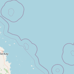
Map view of Broad Sound Islands National Park

Use this park location map to pinpoint Broad Sound Islands National Park in Australia, understand its exact geographic position, and read its mapped placement within the surrounding landscape more clearly.

Pigeon | © OpenStreetMap contributors

Location context for Broad Sound Islands National Park

Queensland
Park atlas

Trace the Coastal Protected Landscapes and Island Chains of Queensland and Australia

Explore Nearby National Parks and Protected Areas Surrounding Broad Sound Islands National Park
After exploring Broad Sound Islands National Park, browse other protected areas within Queensland's expansive coastline and discover additional island national parks across Australia's diverse marine environments. Compare the geographic spread and conservation value of protected landscapes, providing a deeper atlas view of Queensland's coastal park network and marine reptile habitats.
National parkQueensland

West Hill National Park: Explore Queensland's National Park Geography and Mapped Protected Boundaries

Central Queensland Protected Landscape and Atlas Context

West Hill National Park represents a key protected area within Queensland's natural environment network. As a national park, it offers insights into the region's geography and landscape character, contributing to a structured understanding of protected lands. Explore the mapped boundaries and discover its specific place within the atlas of Australian parks, providing context for its conservation significance in central Queensland.

Area
10.8 km²
Established
1971
IUCN
II
Scope
Terrestrial
National parkMackay Region

Cape Palmerston National Park: Coastal Protected Area and Geographic Context in Mackay Region

Mapped landscape, dune systems, and mangrove ecosystems.

Delve into the protected landscape of Cape Palmerston National Park, a significant national park in Australia's Mackay Region. This page offers detailed insights into its geographic identity, characterized by 28 kilometers of pristine coastline, dynamic sand dunes, and extensive mangrove forests. Understand its position within the Central Mackay Coast bioregion and explore the mapped boundaries of this diverse protected area, from its beaches to the inland woodland habitats and wetland basins, providing essential atlas context for this unique coastal environment.

Area
71.9 km²
Established
1976
IUCN
II
Relief
Mixed relief
National parkQueensland

Round Top Island National Park: Protected Island Landscape in Queensland

Explore mapped boundaries and regional conservation context.

Round Top Island National Park preserves the natural character of a small coastal island in Queensland's Coral Sea region. This national park offers a clear example of an entire island protected area, contributing to the broader atlas of Australian conservation landscapes. Understanding its mapped boundaries and its place within North Queensland's geography provides insight into the diversity of protected island ecosystems preserved for their ecological significance.

Area
0.19 km²
IUCN
II
Relief
Mixed relief
Scope
Mixed
National parkQueensland

Mount O'Connell National Park: Queensland National Park, Protected Landscape, and Geographic Context

Discover the mapped terrain and regional boundaries within Queensland's natural geography.

Delve into Mount O'Connell National Park, a protected area offering critical insights into Queensland's regional geography and natural landscapes. This national park serves as a vital point for understanding mapped boundaries and the specific protected-area characteristics that define its identity. Users can explore its geographic context within Queensland, providing a solid foundation for atlas-driven discovery and detailed landscape analysis.

Area
7.57 km²
Established
1989
IUCN
II
Relief
Mixed relief
National parkQueensland

Reliance Creek National Park: Preserving Queensland's Coastal Palm Forest Ecosystem

Mapped protected landscape on Queensland's central coast.

Reliance Creek National Park is a critical conservation site in Queensland, safeguarding the most significant remaining area of coastal palm forest. This compact national park protects a unique subtropical ecosystem that has largely vanished from the surrounding regional landscape. Users can explore its precise location and geographic context, understanding its importance as a preserved natural heritage and a testament to the original coastal plain environment.

Area
0.14 km²
Established
1980
IUCN
II
Access
Remote access
National parkQueensland

Dipperu National Park: Queensland's Protected Natural Landscape and Geographic Atlas

Mapped boundaries and regional terrain within this Australian national park.

Dipperu National Park represents a significant protected landscape within Queensland, Australia, offering a deep dive into its national park identity and geographic setting. This entry provides detailed atlas-oriented information on its mapped boundaries, natural terrain, and its role in the regional geography of northeastern Australia. Users can explore its distinct landscape characteristics and understand its conservation significance through a structured geographic lens, complementing the broader atlas of protected areas.

Area
111 km²
Established
1969
IUCN
Ia
Relief
Lowland
National parkQueensland

South Cumberland Islands National Park: Queensland's Dramatic Granite Island Protected Landscape

Explore its unique mapped geography and natural terrain.

South Cumberland Islands National Park, situated in Queensland, Australia, is a remarkable collection of islands characterized by dramatic granite landscapes, steep interior slopes cloaked in tropical rainforest, and surrounding coral fringing reefs. As the largest island, Scawfell Island rises to a prominent 397-metre peak, showcasing the island group's significant geological features and contributing to its distinct protected landscape identity within the Whitsunday region. Understanding this park offers insight into the mapped natural context of Australia's coastal protected areas.

Area
21.8 km²
IUCN
II
Relief
Mountain
Climate
Subtropical
National parkQueensland

Pioneer Peaks National Park: Queensland National Park Geography and Mapped Boundaries

Explore its protected landscape and regional context.

Pioneer Peaks National Park represents a distinct protected area within Queensland, Australia, offering valuable insights into regional geography and mapped natural landscapes. This canonical page focuses on the park's identity as a national park, detailing its geographic setting and the significance of its protected boundaries. It serves as a crucial point for understanding its place within the Australian atlas and the broader context of conservation landscapes.

Area
18.4 km²
Established
1992
IUCN
II
Relief
Mountain

Common questions about visiting, size, designation, and location context for Broad Sound Islands National Park

Broad Sound Islands National Park FAQs for park facts, access, geography, and protected area context
Find quick answers about Broad Sound Islands National Park, including protected-area facts, park geography, trail and visitor context, and how the park fits into its surrounding country and regional landscape.
MoriAtlas Explorer

Continue Your Protected Areas Search Across the Global Atlas

Deepen your exploration by continuing the structured search for national parks and protected areas worldwide. Utilize the comprehensive filtering capabilities to compare different conservation landscapes and refine your understanding of global park geography. Discover more about the distribution and characteristics of protected natural areas.

Global natural geography