Mori Atlas logo
National parkMount O'Connell National Park

Discover the mapped boundaries and regional geographic context of this Queensland protected area.

Mount O'Connell National Park: Queensland National Park Atlas and Protected Landscape

Mount O'Connell National Park stands as a significant protected landscape within the diverse geography of Queensland, Australia. This dedicated national park offers a unique lens for exploring the state's natural terrain and mapped boundaries. As an integral part of Queensland's natural heritage, the park invites detailed atlas-based discovery, allowing for a deeper understanding of its protected-area identity and geographic significance within the broader regional context.

National ParkQueenslandBrigalow BeltMountain LandscapeProtected AreaEastern Australia

Mount O'Connell National Park

National park

Park overview

Structured park overview, official facts, and landscape profile for Mount O'Connell National Park

Mount O'Connell National Park park facts, protected area profile, and essential visitor context
Review the core facts for Mount O'Connell National Park, including designation, size, terrain, visitor scale, habitats, and operating context in one park-focused overview.

About Mount O'Connell National Park

Mount O'Connell National Park protects a mountainous landscape in central Queensland that stands out against the surrounding Brigalow Belt terrain. The Brigalow Belt is one of Queensland's major bioregions, characterized by a complex mosaic of ecosystems ranging from open woodlands to grasslands and river corridors. This national park, while small in area, serves as a protected refuge for the distinctive flora and landforms associated with Mount O'Connell itself. The park's establishment in 1989 reflected a growing recognition of the need to preserve representative examples of Queensland's diverse landscapes and ecosystems. The protection of Mount O'Connell ensures that this geological feature and its associated biological communities remain intact for future generations.

Quick facts and research context for Mount O'Connell National Park

Mount O'Connell National Park occupies 7.57 square kilometers in central Queensland, established in 1989 and managed by the Queensland Parks and Wildlife Service. The park is located near the small community of Marlborough, approximately 605 kilometers northwest of Brisbane. It lies within the Brigalow Belt bioregion, a recognized area of biodiversity in eastern Australia, and encompasses the slopes of Mount O'Connell itself.

Park context

Deeper park guide and search-rich context for Mount O'Connell National Park

Mount O'Connell National Park history, landscape, wildlife, and travel context
Explore Mount O'Connell National Park through its history, landscape character, ecosystems, wildlife, conservation priorities, cultural context, and seasonal travel timing in a structured park guide built for atlas discovery and search intent.

Why Mount O'Connell National Park stands out

The park is best known for its namesake mountain, Mount O'Connell, which forms the physical and symbolic heart of the protected area. The mountain and its surrounding slopes provide a distinctive landscape feature within the otherwise relatively flat Brigalow Belt terrain. Additionally, the park is notable for the presence of Atalaya multiflora, a tree species identified within its boundaries, representing the botanical diversity of this semi-tropical inland region.

Mount O'Connell National Park history and protected-area timeline

Mount O'Connell National Park was officially established in 1989 through the Queensland Parks and Wildlife Service, which continues to manage the protected area. The creation of this park aligned with broader efforts during the late 1980s to expand Queensland's national park system and protect representative samples of the state's varied bioregions. The Brigalow Belt, within which the park lies, had undergone significant land clearing for agriculture and pastoral use by this time, making protected areas like Mount O'Connell increasingly important for biodiversity conservation. The park preserves a landscape that retains much of its natural character despite surrounding development pressures in the broader region.

Mount O'Connell National Park landscape and geographic character

The landscape of Mount O'Connell National Park is defined by its namesake mountain, which rises from the surrounding plains of the Brigalow Belt. The terrain consists of slopes leading up to the mountain's summit, with the park encompassing portions of this elevated landform and its foot slopes. The underlying geology and soils of the area support distinctive vegetation communities that differ from the surrounding lowland areas. This combination of elevated terrain and associated habitats creates a landscape of moderate topographic variation within a region that is otherwise predominantly flat or gently undulating.

Mount O'Connell National Park ecosystems, habitats, and plant life

The nature of Mount O'Connell National Park is shaped by its location within the Brigalow Belt bioregion, a region known for its ecological diversity and complexity. The park's vegetation includes woodland and open forest communities typical of inland central Queensland, interspersed with more open grassland areas. The presence of Atalaya multiflora has been documented within the park, representing one of the notable botanical records for the area. This tree species is part of the broader flora that characterizes the Brigalow Belt's diverse plant communities. The park's position within the Shoalwater drainage sub-basin also connects it to broader hydrological systems that support additional habitat types and ecological processes.

Mount O'Connell National Park wildlife and species highlights

While detailed wildlife records for Mount O'Connell National Park are limited in the available source material, the Brigalow Belt bioregion is known to support a rich diversity of fauna. The region provides habitat for numerous bird species, reptiles, mammals, and invertebrates that have adapted to its mix of woodland, grassland, and riparian environments. The protected mountain environment within the park likely offers additional habitat complexity and microhabitats that support species not found in the surrounding cleared or grazing lands. The combination of woodland cover and elevated terrain creates conditions suitable for both forest-dwelling and more open-country species.

Mount O'Connell National Park conservation status and protection priorities

Mount O'Connell National Park contributes to the conservation of the Brigalow Belt bioregion, which has experienced significant habitat loss due to agricultural expansion and land clearing. The park protects a representative example of the region's natural landscapes, including the distinctive mountain environment of Mount O'Connell. Protected areas within the Brigalow Belt serve as important refuges for native species and help maintain ecological processes in a region where much of the original vegetation has been modified. The presence of Atalaya multiflora within the park highlights the botanical values that protected status helps preserve.

Mount O'Connell National Park cultural meaning and human context

The cultural context of Mount O'Connell National Park is not extensively documented in the available source material. The broader Brigalow Belt region has traditional associations with Aboriginal peoples, though specific cultural heritage information for the Mount O'Connell area is not provided in the source. The landscape has been part of the natural environment that has supported human communities in central Queensland over long time periods.

Top sights and standout views in Mount O'Connell National Park

The primary highlight of Mount O'Connell National Park is the mountain itself, which provides the defining character of the protected area. The park offers the opportunity to explore a distinctive elevated landscape within the generally flat Brigalow Belt terrain. The documented presence of Atalaya multiflora represents a botanical highlight, showcasing the park's contribution to regional plant diversity. The park's location within the Shoalwater drainage sub-basin connects it to broader watershed values.

Best time to visit Mount O'Connell National Park

The best time to visit Mount O'Connell National Park would typically be during the cooler, drier months of winter and spring in Queensland, from around May through October. During this period, temperatures are more comfortable for outdoor exploration and the landscape is generally less affected by summer rainfall and humidity. The dry season also typically offers clearer conditions for viewing the mountain and surrounding terrain. Summer months in central Queensland can be hot and may include periods of high rainfall, which could affect visitability and trail conditions.

Park location guide

Geography guide, regional context, and park location map for Mount O'Connell National Park

Mount O'Connell National Park park geography, regions, and map view in Australia
Understand where Mount O'Connell National Park sits in Australia through a broader geographic reading of the surrounding landscape, nearby location context, and its mapped position within the national park landscape.

How Mount O'Connell National Park fits into Australia

Australia is a constitutional monarchy and federal parliamentary democracy comprising six states and ten territories. With a population of nearly 28 million, it is one of the world's most urbanised countries, with most people concentrated on the eastern seaboard. The country has a high Human Development Index and is known for its cultural diversity, ancient Aboriginal heritage, and unique wildlife.

Wider geography shaping Mount O'Connell National Park in Australia

Australia occupies the entire Australian continent, the island of Tasmania, and numerous smaller islands. It is the world's flattest and driest inhabited continent, featuring vast deserts in the interior (the Outback), tropical rainforests along the eastern coast, and a coastline bordering the Indian and Pacific Oceans.

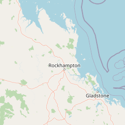
Map view of Mount O'Connell National Park

Use this park location map to pinpoint Mount O'Connell National Park in Australia, understand its exact geographic position, and read its mapped placement within the surrounding landscape more clearly.

Pigeon | © OpenStreetMap contributors

Location context for Mount O'Connell National Park

Queensland
Park atlas

Trace the regional spread of protected areas and compare similar conservation landscapes near Mount O'Connell National Park.

Browse Protected Areas and National Parks Near Mount O'Connell National Park, Brigalow Belt
Browse additional protected landscapes, national parks, and nature reserves situated near Mount O'Connell National Park within Queensland's expansive Brigalow Belt bioregion. This focused comparison allows for deeper understanding of regional conservation efforts and how different protected entities integrate into the broader Eastern Australian terrain.
National parkQueensland

Goodedulla National Park: Queensland National Park Atlas and Geographic Exploration

Discover its mapped protected area and landscape context.

Goodedulla National Park is a designated national park in Queensland, Australia, offering a focused entry point for atlas exploration of protected landscapes. Understand its specific geographic scope, mapped boundaries, and how it fits within the natural and regional context of Queensland. This resource is tailored for users interested in the detailed geography and protected-area data of Australia's natural landscapes.

Area
255 km²
Established
1994
IUCN
II
Relief
Lowland
Watercolor illustration showing a landscape with hills, trees, and distant mountains under a light sky
National parkQueensland

Mount Etna Caves National Park: Queensland National Park Protected Landscape and Map

Explore the geographic boundaries and natural terrain of this Australian park.

Mount Etna Caves National Park is a protected national park located in Queensland, Australia. This page facilitates an atlas-style discovery of its geographic features and mapped boundaries. Understand how this protected landscape contributes to the regional geography of northeastern Australia, providing essential context for cartographic and geographic exploration.

Area
4.78 km²
Established
1994
IUCN
II
Relief
Lowland
National parkQueensland

Byfield National Park: Protected National Park with Coastal Dune Ecosystems in Queensland

Explore its mapped landscape and unique pandanus forests.

Byfield National Park presents a compelling case study in coastal protected-area geography, showcasing a diverse landscape where dune systems meet extensive pandanus forests across 12 kilometers of Queensland coastline. This national park, established in 1988, provides a unique glimpse into the ecological transition zone between tropical savanna and subtropical climates, offering a richly detailed environment for map-based exploration. Its relatively undeveloped terrain and distinct ecosystems make it a valuable entity for understanding regional Australian natural landscapes and conservation efforts.

Area
87 km²
Established
1988
IUCN
II
Relief
Lowland
National parkQueensland

Baga National Park: Unique Volcanic Geography and Protected Landscape in Queensland

Mapped terrain and protected area identity for a distinctive national park.

Baga National Park stands as a notable protected area in central Queensland, Australia, centered around the striking Mount Baga, a trachyte volcanic plug. This geological marvel offers a unique landscape context, showcasing the remnants of ancient volcanic activity within the regional geography. As a national park, it serves to preserve this distinctive natural feature and its associated habitats, providing a compact yet significant destination for atlas-based discovery of Queensland's diverse protected lands.

Area
1.44 km²
Established
1977
IUCN
II
Relief
Mountain
National parkShire of Livingstone

Capricorn Coast National Park: Mapped Protected Area and Regional Geography

Explore its geographic setting within Shire of Livingstone.

Capricorn Coast National Park is a key protected landscape offering significant geographic detail for atlas exploration. Situated within the Shire of Livingstone, this national park's mapped boundaries and regional context are crucial for understanding its role as a protected natural area. Delve into the specific geography that shapes this Australian park and its contribution to conservation landscapes.

Area
1.14 km²
Established
1992
IUCN
II
Relief
Lowland
National parkQueensland

Mount Archer National Park: Queensland National Park Geography and Protected Landscape

Mapped boundaries and regional terrain discovery in northeastern Australia.

Mount Archer National Park is a designated national park contributing to the protected landscape mosaic of Queensland, Australia. This entry provides a focused look at its geographic attributes, mapped outlines, and its significance within the state's natural geography. Users exploring this protected area can gain insight into its specific landform characteristics and its role within the structured discovery offered by MoriAtlas for understanding Australia's conservation network.

Area
36.1 km²
Established
1994
IUCN
II
Relief
Mountain
National parkQueensland

Keppel Bay Islands National Park: Queensland's Coastal National Park and Archipelago Discovery

Explore protected islands, mapped coral reefs, and marine ecosystems.

Delve into the geographic identity of Keppel Bay Islands National Park, a significant protected area comprising thirteen islands off the coast of Queensland. This national park showcases a dynamic coastal landscape, featuring distinct island terrains, diverse marine life, and essential coral reef systems. Through its mapped boundaries and conservation focus, the park offers a unique lens for understanding island geography and the importance of marine protected areas within the broader Australian atlas.

Area
7.2 km²
Established
1994
IUCN
II
Relief
Lowland
National parkQueensland

Broad Sound Islands National Park: Queensland National Park Geographic Atlas

Mapped protected boundaries and landscape context in Queensland.

Broad Sound Islands National Park serves as a vital point of reference for exploring Queensland's protected natural areas. This canonical detail entry provides essential insights into the park's geographic positioning, its role as a national park, and its contribution to the regional atlas. Understand its mapped boundaries and unique landscape characteristics as part of a structured geographic discovery.

Area
16 km²
IUCN
II
Relief
Lowland
Climate
Subtropical

Common questions about visiting, size, designation, and location context for Mount O'Connell National Park

Mount O'Connell National Park FAQs for park facts, access, geography, and protected area context
Find quick answers about Mount O'Connell National Park, including protected-area facts, park geography, trail and visitor context, and how the park fits into its surrounding country and regional landscape.
MoriAtlas Explorer

Continue Your Protected Areas Search Across the Global Atlas

Deepen your exploration by continuing the structured search for national parks and protected areas worldwide. Utilize the comprehensive filtering capabilities to compare different conservation landscapes and refine your understanding of global park geography. Discover more about the distribution and characteristics of protected natural areas.

Global natural geography