

Mori Atlas logo
National parkMount Etna Caves National Park

Discover the mapped boundaries and natural terrain of this Australian national park.

Mount Etna Caves National Park: Queensland's Protected Landscape and Regional Geography

Mount Etna Caves National Park represents a significant protected landscape within the diverse geography of Queensland, Australia. As a national park, it offers vital context for understanding the region's mapped terrain and protected areas. This page serves as your atlas entry point to explore the park's geographic identity and its place within the broader natural context of northeastern Australia.

Bat coloniesLimestone cavesKarst landscapeQueensland protected areaSubterranean ecosystemsEndangered species habitat
Illustrated scene featuring a waterfall flowing through rocky mountains with a river and forested valley

Mount Etna Caves National Park

National park

Park overview

Structured park overview, official facts, and landscape profile for Mount Etna Caves National Park

Mount Etna Caves National Park park facts, protected area profile, and essential visitor context
Review the core facts for Mount Etna Caves National Park, including designation, size, terrain, visitor scale, habitats, and operating context in one park-focused overview.

About Mount Etna Caves National Park

Mount Etna Caves National Park represents a rare example of subterranean conservation priority in Australia's protected area network. The park's limestone cave systems have developed over millions of years through the dissolution of carbonate rock, creating a network of passages and chambers that provide stable environmental conditions year-round. This stability makes the caves exceptionally valuable as roosting sites for colonial bat species that require consistent microclimates for breeding success. The little bent-wing bat, despite being relatively widespread across eastern Australia, relies on a limited number of major breeding colonies, and Mount Etna Caves hosts the largest of these. The ghost bat, once more widely distributed across northern Australia, now persists in only a handful of locations, making this colony particularly important for species survival. The park's above-ground environment consists of open woodland and rocky terrain typical of the central Queensland slopes, providing foraging habitat for the bats in the surrounding landscape. Access to the cave systems is restricted to protect the sensitive bat colonies, particularly during breeding season when disturbance could have devastating effects on pup survival rates.

Quick facts and research context for Mount Etna Caves National Park

Mount Etna Caves National Park covers approximately 4.78 square kilometers in central Queensland's Livingstone Shire. The park is managed by the Queensland Parks and Wildlife Service. It was originally gazetted as Fitzroy Caves National Park in 1973 and renamed to Mount Etna Caves National Park in 1990 before being expanded in 1999. The park's primary conservation focus is the protection of cave-dwelling bat species, particularly the little bent-wing bat and the endangered ghost bat.

Park context

Deeper park guide and search-rich context for Mount Etna Caves National Park

Mount Etna Caves National Park history, landscape, wildlife, and travel context
Explore Mount Etna Caves National Park through its history, landscape character, ecosystems, wildlife, conservation priorities, cultural context, and seasonal travel timing in a structured park guide built for atlas discovery and search intent.

Why Mount Etna Caves National Park stands out

Mount Etna Caves National Park is renowned for supporting the largest breeding colony of little bent-wing bats in Australia, estimated to represent more than 80 percent of the species' national breeding population. This concentration of breeding activity makes the park globally significant for this particular bat species. Additionally, the park hosts one of the few remaining colonies of ghost bats in Australia, an endangered species that has suffered significant population declines across its former range. The cave systems provide ideal roosting conditions for these nocturnal mammals, offering stable temperature and humidity levels essential for breeding and nursing young.

Panoramic landscape of Mount Etna Caves National Park featuring rocky limestone terrain, dense green vegetation, and rolling hills under an overcast sky
Panoramic view of Mount Etna Caves National Park showcasing limestone karst and vine scrub vegetation

Mount Etna Caves National Park history and protected-area timeline

The conservation history of Mount Etna Caves spans over five decades of evolving understanding about the site's ecological significance. The area was first protected in 1973 under the name Fitzroy Caves National Park, making it one of Australia's earliest protected areas specifically designated for cave-dwelling wildlife rather than scenic landscapes. The initial gazettal reflected a growing recognition that the cave systems warranted protection primarily for the bats that depended on them, rather than for the caves as geological features. In 1990, the park was officially renamed Mount Etna Caves National Park to reflect more accurately its location and the nature of the protected resource. A significant expansion occurred in 1999 when additional land was incorporated into the park to provide more comprehensive protection for the cave systems and their catchments. This expansion acknowledged that effective bat conservation required protecting not just the caves themselves but also the surrounding landscape that supports the bats' ecological needs. The Queensland Parks and Wildlife Service has managed the park throughout this period, implementing access restrictions and monitoring programs to ensure the bats remain protected.

Mount Etna Caves National Park landscape and geographic character

The physical landscape of Mount Etna Caves National Park centers on its limestone karst system, which has been carved by groundwater dissolving the carbonate rock over geological time spans. The caves vary in size and configuration, with some chambers capable of accommodating human visitors while others remain accessible only to the bats that roost within them. The terrain above the caves consists of rolling hills and woodland typical of central Queensland, characterized by eucalyptus trees and native grasses. The nearby Mount Etna, for which the park is named, is a volcanic peak that rises from the landscape, providing a contrasting geological feature to the sedimentary limestone of the caves. The surface environment shows the effects of Queensland's seasonal climate, with wet summers and relatively dry winters shaping the vegetation patterns. Rock outcrops and exposed limestone formations are visible in some areas, giving hints of the subterranean landscape that lies beneath.

Mount Etna Caves National Park ecosystems, habitats, and plant life

The ecological significance of Mount Etna Caves National Park stems primarily from its role as a critical habitat for colonial bat species, but the park's nature extends to encompass broader ecosystem relationships. The little bent-wing bat occupies a key position in the nocturnal food web, feeding on insects and in turn providing prey for predators such as owls and snakes. Their foraging activities across the surrounding woodland help regulate insect populations, providing ecosystem services that benefit the broader environment. The ghost bat, although present in smaller numbers, represents a larger-bodied predatory bat species that hunts larger prey including small vertebrates. The caves themselves support a range of other organisms adapted to dark, stable conditions, including invertebrates and fungi that rely on the bat guano that accumulates in the roosting areas. The above-ground woodland provides connectivity to the broader central Queensland landscape, allowing the bats to move between roosting and foraging areas throughout their territory.

Mount Etna Caves National Park wildlife and species highlights

The wildlife of Mount Etna Caves National Park is dominated by its extraordinary bat populations, which represent the park's primary ecological justification for protection. Little bent-wing bats gather in colonies that can number in the thousands, with the Mount Etna caves hosting the vast majority of Australia's breeding population for this species. Breeding typically occurs in spring and summer, with females gathering in warm chambers to give birth and raise their single pups. The ghost bat, while present in smaller numbers, is a particularly notable resident given its endangered conservation status and declining populations across Australia. These larger bats can be distinguished by their pale, almost translucent wings when backlit. The surrounding woodland provides habitat for various bird species and other wildlife, though the park's small size means that most visitors come specifically to learn about and appreciate the bats rather than to observe diverse fauna. The cave environments themselves are too dark for most wildlife, but the bat colonies create a unique subterranean ecosystem dependent on the mammals' presence.

Mount Etna Caves National Park conservation status and protection priorities

Mount Etna Caves National Park represents one of Australia's most important sites for cave-dwelling bat conservation, with protection measures focused on both the underground roosting sites and the surrounding landscape that supports viable bat populations. The concentration of little bent-wing bats at this site means that threats to the colony could have population-level impacts across the entire species, making the park's protection critical for national biodiversity. Ghost bat conservation benefits from the park's protection as well, since the species has lost much of its former range to habitat disturbance and human activity. The park's management includes restrictions on public access to sensitive cave areas, particularly during breeding seasons when the bats are most vulnerable to disturbance. Ongoing research and monitoring programs track population trends and roost site conditions to ensure conservation measures remain effective. The park demonstrates how small protected areas can have disproportionate ecological value when they contain critical habitat for species with limited distribution.

Mount Etna Caves National Park cultural meaning and human context

Mount Etna Caves National Park does not have a significant documented indigenous cultural history or heritage associated with the cave systems, and the park's management focus has been primarily on ecological conservation rather than cultural landscape values. The surrounding region of central Queensland has indigenous heritage significance in broader terms, though specific connections to the Mount Etna cave sites are not well documented in available sources. The European history of the area is relatively brief, with the caves noted in colonial exploration records and the regional pastoral development occurring in the nineteenth century. The naming of the park after nearby Mount Etna reflects the European geographic naming convention rather than any indigenous toponym. Modern visitation to the park is primarily oriented around bat watching and environmental education, with interpretive materials explaining the ecological significance of the caves and the importance of bat conservation.

Top sights and standout views in Mount Etna Caves National Park

Mount Etna Caves National Park offers visitors the opportunity to witness one of Australia's most remarkable wildlife concentrations at a single site. The little bent-wing bat colonies, numbering in the thousands, represent a spectacle of nature that few other places can match, particularly at dusk when the bats emerge to forage. The ghost bat, while less numerous, adds a dimension of rarity since visitors may observe an endangered species in its natural habitat. The karst landscape itself, with its limestone formations and cave passages, provides geological interest independent of the bats. The park serves as an outdoor classroom for understanding bat ecology, cave ecosystems, and the challenges of conserving species that depend on specific roosting sites. Even from above ground, the woodland setting offers a peaceful backdrop for appreciating this unusual protected area.

Best time to visit Mount Etna Caves National Park

The optimal time to visit Mount Etna Caves National Park depends on what visitors hope to experience, with different seasons offering different advantages. The little bent-wing bats are most active and visible during the warmer months of spring and summer, when breeding activity brings large numbers of bats to the caves and evening emergences become more dramatic. Autumn and winter months see reduced bat activity as the colonies potentially move to other roosting sites or reduce their activity levels in response to cooler temperatures. The cave environments maintain relatively stable conditions throughout the year, but the above-ground experience varies with Queensland's seasonal climate, with summer bringing heat and occasional storms while winter offers milder, drier conditions. Visitors interested in bat watching should plan their visit for the hours around sunset when the bats emerge from the caves to forage, though specific timing varies throughout the year based on sunset times and bat behavior patterns.

Park location guide

Geography guide, regional context, and park location map for Mount Etna Caves National Park

Mount Etna Caves National Park park geography, regions, and map view in Australia
Understand where Mount Etna Caves National Park sits in Australia through a broader geographic reading of the surrounding landscape, nearby location context, and its mapped position within the national park landscape.

How Mount Etna Caves National Park fits into Australia

Australia is a constitutional monarchy and federal parliamentary democracy comprising six states and ten territories. With a population of nearly 28 million, it is one of the world's most urbanised countries, with most people concentrated on the eastern seaboard. The country has a high Human Development Index and is known for its cultural diversity, ancient Aboriginal heritage, and unique wildlife.

Wider geography shaping Mount Etna Caves National Park in Australia

Australia occupies the entire Australian continent, the island of Tasmania, and numerous smaller islands. It is the world's flattest and driest inhabited continent, featuring vast deserts in the interior (the Outback), tropical rainforests along the eastern coast, and a coastline bordering the Indian and Pacific Oceans.

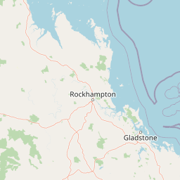
Map view of Mount Etna Caves National Park

Use this park location map to pinpoint Mount Etna Caves National Park in Australia, understand its exact geographic position, and read its mapped placement within the surrounding landscape more clearly.

Pigeon | © OpenStreetMap contributors

Location context for Mount Etna Caves National Park

Queensland

Explore the distinctive limestone formations, critical bat roosts, and surrounding Queensland woodland scenery through detailed imagery.

Mount Etna Caves National Park Photos: A Visual Guide to its Unique Karst Landscapes and Protected Bat Habitats
Browse comprehensive imagery of Mount Etna Caves National Park to understand its unique karst landscapes, the entrances to its crucial subterranean cave systems, and the surrounding Queensland woodland terrain. These visual references offer essential context for appreciating the park's ecological role as a vital habitat for Australia's significant bat colonies and endangered species.

Panoramic landscape of Mount Etna Caves National Park featuring rocky limestone terrain, dense green vegetation, and rolling hills under an overcast sky

Park atlas

Explore the unique karst landscapes and regional protected areas surrounding this vital bat habitat.

Discover Other National Parks Near Mount Etna Caves National Park in Queensland, Australia
Explore a curated list of national parks and protected areas located near Mount Etna Caves National Park in central Queensland. Comparing these regional conservation landscapes reveals diverse ecosystems, from significant subterranean cave systems to varied woodland habitats, offering broader geographic context and discovery opportunities.
National parkQueensland

Baga National Park: Unique Volcanic Geography and Protected Landscape in Queensland

Mapped terrain and protected area identity for a distinctive national park.

Baga National Park stands as a notable protected area in central Queensland, Australia, centered around the striking Mount Baga, a trachyte volcanic plug. This geological marvel offers a unique landscape context, showcasing the remnants of ancient volcanic activity within the regional geography. As a national park, it serves to preserve this distinctive natural feature and its associated habitats, providing a compact yet significant destination for atlas-based discovery of Queensland's diverse protected lands.

Area
1.44 km²
Established
1977
IUCN
II
Relief
Mountain
National parkQueensland

Mount Archer National Park: Queensland National Park Geography and Protected Landscape

Mapped boundaries and regional terrain discovery in northeastern Australia.

Mount Archer National Park is a designated national park contributing to the protected landscape mosaic of Queensland, Australia. This entry provides a focused look at its geographic attributes, mapped outlines, and its significance within the state's natural geography. Users exploring this protected area can gain insight into its specific landform characteristics and its role within the structured discovery offered by MoriAtlas for understanding Australia's conservation network.

Area
36.1 km²
Established
1994
IUCN
II
Relief
Mountain
National parkShire of Livingstone

Capricorn Coast National Park: Mapped Protected Area and Regional Geography

Explore its geographic setting within Shire of Livingstone.

Capricorn Coast National Park is a key protected landscape offering significant geographic detail for atlas exploration. Situated within the Shire of Livingstone, this national park's mapped boundaries and regional context are crucial for understanding its role as a protected natural area. Delve into the specific geography that shapes this Australian park and its contribution to conservation landscapes.

Area
1.14 km²
Established
1992
IUCN
II
Relief
Lowland
National parkQueensland

Keppel Bay Islands National Park: Queensland's Coastal National Park and Archipelago Discovery

Explore protected islands, mapped coral reefs, and marine ecosystems.

Delve into the geographic identity of Keppel Bay Islands National Park, a significant protected area comprising thirteen islands off the coast of Queensland. This national park showcases a dynamic coastal landscape, featuring distinct island terrains, diverse marine life, and essential coral reef systems. Through its mapped boundaries and conservation focus, the park offers a unique lens for understanding island geography and the importance of marine protected areas within the broader Australian atlas.

Area
7.2 km²
Established
1994
IUCN
II
Relief
Lowland
National parkQueensland

Byfield National Park: Protected National Park with Coastal Dune Ecosystems in Queensland

Explore its mapped landscape and unique pandanus forests.

Byfield National Park presents a compelling case study in coastal protected-area geography, showcasing a diverse landscape where dune systems meet extensive pandanus forests across 12 kilometers of Queensland coastline. This national park, established in 1988, provides a unique glimpse into the ecological transition zone between tropical savanna and subtropical climates, offering a richly detailed environment for map-based exploration. Its relatively undeveloped terrain and distinct ecosystems make it a valuable entity for understanding regional Australian natural landscapes and conservation efforts.

Area
87 km²
Established
1988
IUCN
II
Relief
Lowland
National parkQueensland

Mount O'Connell National Park: Queensland National Park, Protected Landscape, and Geographic Context

Discover the mapped terrain and regional boundaries within Queensland's natural geography.

Delve into Mount O'Connell National Park, a protected area offering critical insights into Queensland's regional geography and natural landscapes. This national park serves as a vital point for understanding mapped boundaries and the specific protected-area characteristics that define its identity. Users can explore its geographic context within Queensland, providing a solid foundation for atlas-driven discovery and detailed landscape analysis.

Area
7.57 km²
Established
1989
IUCN
II
Relief
Mixed relief
National parkQueensland

Goodedulla National Park: Queensland National Park Atlas and Geographic Exploration

Discover its mapped protected area and landscape context.

Goodedulla National Park is a designated national park in Queensland, Australia, offering a focused entry point for atlas exploration of protected landscapes. Understand its specific geographic scope, mapped boundaries, and how it fits within the natural and regional context of Queensland. This resource is tailored for users interested in the detailed geography and protected-area data of Australia's natural landscapes.

Area
255 km²
Established
1994
IUCN
II
Relief
Lowland
National parkQueensland

Rundle Range National Park: Queensland's National Park Protected Landscape Exploration

Explore its mapped boundaries and regional geographic context.

Delve into the protected landscape of Rundle Range National Park, a designated national park situated within Queensland, Australia. This entry provides focused insights into its geographic setting, mapped park boundaries, and its significance as a protected area. It is designed to aid in understanding the park's specific natural context and its place within the broader Queensland regional geography for detailed atlas discovery.

Area
21.7 km²
Established
1993
IUCN
II
Scope
Terrestrial

Common questions about visiting, size, designation, and location context for Mount Etna Caves National Park

Mount Etna Caves National Park FAQs for park facts, access, geography, and protected area context
Find quick answers about Mount Etna Caves National Park, including protected-area facts, park geography, trail and visitor context, and how the park fits into its surrounding country and regional landscape.
MoriAtlas Explorer

Continue Your Protected Areas Search Across the Global Atlas

Deepen your exploration by continuing the structured search for national parks and protected areas worldwide. Utilize the comprehensive filtering capabilities to compare different conservation landscapes and refine your understanding of global park geography. Discover more about the distribution and characteristics of protected natural areas.

Global natural geography