

Mori Atlas logo
National parkBukhansan National Park

Understand the geographic setting and protected area boundaries of this key national park.

Bukhansan National Park: A Mapped Protected Landscape in Gyeonggi Province

(Bukhansan National Park (북한산국립공원))

Delve into the detailed geography and protected landscape of Bukhansan National Park, a significant national park situated within Gyeonggi Province. This entry offers an atlas-focused perspective, highlighting the park's mapped boundaries and its regional geographic context. It serves as a crucial point for understanding the protected area's place in the landscape and for structured discovery within the broader map of natural reserves.

Granite MountainsHistoric FortressUrban ProximityHiking TrailsSouth KoreaSeoul Vicinity

Bukhansan National Park

National park

Park overview

Structured park overview, official facts, and landscape profile for Bukhansan National Park

Bukhansan National Park park facts, protected area profile, and essential visitor context
Review the core facts for Bukhansan National Park, including designation, size, terrain, visitor scale, habitats, and operating context in one park-focused overview.

About Bukhansan National Park

Bukhansan National Park sits at the northern edge of the Seoul metropolitan area, straddling both the city proper and Gyeonggi Province. The park's establishment in 1983 marked a critical step in preserving what remained of the natural landscape surrounding South Korea's capital city. The park's name derives from the Han River, which flows through central Seoul; "Bukhan" refers to the north side of this river, though the linguistic similarity to "North Korea" (북조선/조선) has occasionally caused confusion among international visitors. The park protects a diverse landscape of steep granite cliffs, forested valleys, mountain streams, and the historic fortification complex that has watched over Seoul for nearly two millennia. Despite its proximity to one of the world's largest metropolitan areas, the park maintains significant ecological value and serves as a critical green space for Seoul residents seeking outdoor recreation. The Korea National Park Service manages visitor access through a rotational trail closure system on certain routes to allow sensitive areas to recover from the heavy foot traffic the park receives.

Quick facts and research context for Bukhansan National Park

Bukhansan National Park occupies roughly 80 square kilometers across Seoul and Gyeonggi Province in South Korea. The park was established in 1983 and is managed by the Korea National Park Service. The three principal peaks are Baekundae (836.5 meters), Insubong (810.5 meters), and Mangnyeongdae (799.5 meters), all composed of ancient granite. The park contains Bukhansanseong Fortress, a historic defensive wall stretching 9.5 kilometers along the ridgeline that was originally constructed in 132 AD and expanded in 1711. The park is known for its extensive trail network including the 70-kilometer Dulle-gil Trail, and its accessibility from central Seoul has made it a primary recreation area for urban residents.

Park context

Deeper park guide and search-rich context for Bukhansan National Park

Bukhansan National Park history, landscape, wildlife, and travel context
Explore Bukhansan National Park through its history, landscape character, ecosystems, wildlife, conservation priorities, cultural context, and seasonal travel timing in a structured park guide built for atlas discovery and search intent.

Why Bukhansan National Park stands out

Bukhansan National Park is best known for its dramatic granite peak formations rising abruptly from the Seoul metropolitan area, providing a striking mountain backdrop visible from many parts of the city. The park's Bukhansanseong Fortress, with its 9.5-kilometer defensive wall dating to the 2nd century, represents one of the most significant historical fortifications within a South Korean national park. The park is also renowned for its extensive trail network catering to all hiking skill levels, from the popular ascent to Baekundae peak to the more challenging rock-climbing routes at Dobongsan. The accessibility of the park from central Seoul, combined with its natural and cultural significance, has made it the most visited national park in South Korea.

Bukhansan National Park history and protected-area timeline

The history of Bukhansan extends far beyond its designation as a national park in 1983. The most significant historical feature within the park is Bukhansanseong Fortress, which was first constructed in 132 AD during the Three Kingdoms period to protect the then-capital of Seoul (then known as Wiryeseong) from foreign invasions. The fortress was substantially expanded in 1711 during the Joseon Dynasty, reaching its current configuration of approximately 9.5 kilometers of defensive walls, observation posts, and fortification structures built along the mountain ridges. The fortress sustained significant damage during the Korean War in the 1950s but was subsequently reconstructed. More recently, there has been a movement among local government officials and preservation groups to revert the park's name from Bukhansan to its original collective name, Samgaksan ("three horned mountains"), which historically referred to the three principal peaks before the modern name came into common use.

Bukhansan National Park landscape and geographic character

The landscape of Bukhansan National Park is defined by its trio of prominent granite peaks rising abruptly from the surrounding lowland terrain. The highest peak, Baekundae, reaches 836.5 meters above sea level and offers panoramic views across the Seoul metropolitan area on clear days. The granite formations throughout the park are characterized by steep rock faces, boulder fields, and distinctive dome-shaped summits that have been shaped by weathering and erosion over millions of years. The mountain slopes are covered in mixed deciduous and evergreen forest, with valleys and drainages supporting denser vegetation communities. The park's terrain is rugged and mountainous, with steep ascents and descents characterizing most trail routes, though the Dulle-gil Trail follows more gentle paths along foothills and through surrounding villages. The fortress wall constructed along the ridge lines adds a distinctive human element to the natural granite landscape, with stone fortifications following the natural contours of the peaks.

Bukhansan National Park ecosystems, habitats, and plant life

The nature of Bukhansan reflects its position at the intersection of urban and rural landscapes in South Korea. The park's forested areas contain a mix of tree species typical of the Korean peninsula, with both deciduous and coniferous species represented across different elevations and aspects. The granite-based soils support vegetation communities adapted to the sometimes harsh conditions of exposed rock faces and steep slopes. The park's accessibility from Seoul has created significant pressure on its natural systems, which is why the Korea National Park Service implements rotational trail closures to allow vegetation recovery in high-traffic areas. Despite this pressure, the park maintains habitats for various bird species and smaller mammals that persist in the urban-adjacent environment. The seasonal changes are pronounced, with spring bringing azalea blooms across the mountain slopes, summer offering lush green forest cover, autumn displaying vibrant fall colors, and winter creating a dramatically different snow-covered landscape that attracts different visitors seeking quiet mountain solitude.

Bukhansan National Park wildlife and species highlights

The wildlife of Bukhansan reflects the park's position as an island of natural habitat within the Seoul metropolitan region. While large mammals are less common due to the park's small size and heavy human use, the forested areas and rocky outcrops support various bird species, including both resident and migratory birds that utilize the corridor formed by the mountain ridge. The park's Buddhist temples, including those within the fortress complex, have historically provided cultural connections between the mountain landscape and spiritual practice. The diverse microhabitats created by the mix of forest, rock, and developed areas support insect populations and smaller creatures that form the base of the food chain. The Korean National Park Service monitors wildlife populations and implements management strategies to maintain biodiversity within the park's boundaries, though the intense recreational use naturally limits the presence of more sensitive species.

Bukhansan National Park conservation status and protection priorities

Bukhansan National Park represents both the challenges and importance of protecting natural areas within heavily populated metropolitan regions. The park's status as IUCN Category II reflects its primary purpose of protecting natural landscapes while allowing sustainable recreational use. The Korea National Park Service faces the ongoing challenge of balancing the approximately five million annual visitors with the need to preserve the park's natural and cultural resources. The rotational trail closure system is one management tool used to address this pressure, allowing specific trails to rest and regenerate while alternatives remain open. The protection of Bukhansanseong Fortress adds a cultural dimension to the park's conservation mandate, requiring coordination between natural and cultural resource management. The park's proximity to Seoul makes it a critical green infrastructure element for the metropolitan region, providing ecosystem services including air quality improvement, watershed protection, and psychological benefits for urban residents seeking natural experiences without traveling far from the city.

Bukhansan National Park cultural meaning and human context

The cultural context of Bukhansan extends beyond its designation as a national park to encompass nearly two thousand years of human history connected to this mountain landscape. The Bukhansanseong Fortress represents one of the oldest fortification systems in the Seoul area, with origins dating to the early Three Kingdoms period when the mountain's elevated position provided strategic defensive advantages. The fortress was expanded during the Joseon Dynasty into the extensive wall system that remains visible today, making it a significant heritage resource within the national park system. Buddhist temples scattered throughout the park add another layer of cultural significance, with religious structures positioned to take advantage of the mountain's spiritual associations. The ongoing movement to restore the name Samgaksan reflects contemporary interest in recovering and preserving historical accuracy in naming, with the Gangbuk-gu District Office and various preservation groups advocating for the change. The mountain's proximity to Seoul has made it a central element of the city's relationship with nature, serving as a backdrop for daily life, a recreation destination for urban residents, and a symbol of the interplay between Korea's historical landscape and modern urban development.

Top sights and standout views in Bukhansan National Park

The highlights of Bukhansan National Park include the dramatic ascent to Baekundae peak, where hikers are rewarded with sweeping views across the Seoul metropolitan area. The Bukhansanseong Fortress wall offers a unique hiking experience combining natural mountain terrain with historic fortification structures along a 9.5-kilometer ridge route. The Dulle-gil Trail provides a more extensive 70-kilometer loop incorporating 21 sections that wind through forested foothills and surrounding village landscapes. The park's seasonal variety makes it a year-round destination, from spring azalea blooms to summer forest shade, autumn color displays, and winter snow-covered peaks that attract photographers and contemplative visitors alike. The Dobongsan area provides particularly popular rock climbing routes for more experienced outdoor enthusiasts. The ease of access from central Seoul, with subway stations serving several park entry points, makes this mountain park uniquely accessible among world capital cities.

Best time to visit Bukhansan National Park

The best time to visit Bukhansan depends on what experience visitors seek, as the park offers distinct seasonal characteristics throughout the year. Spring, from late March through May, brings azalea blooms and comfortable temperatures, though this is also one of the most popular seasons, meaning trails will be more crowded. Summer offers full forest canopy and long days but can be hot and humid, with occasional monsoon rains in July and August. Autumn, from late September through November, provides perhaps the most visually striking conditions with fall foliage colors transforming the mountain slopes, and temperatures cool to comfortable hiking ranges. Winter creates a dramatically different landscape with snow-covered peaks and frozen streams, offering solitude for those willing to brave the cold. Early morning visits year-round tend to be less crowded regardless of season. The park is open year-round, though some trails may be restricted during winter conditions or during the rotational closures implemented to protect vegetation.

Park location guide

Geography guide, regional context, and park location map for Bukhansan National Park

Bukhansan National Park park geography, regions, and map view in South Korea
Understand where Bukhansan National Park sits in South Korea through a broader geographic reading of the surrounding landscape, nearby location context, and its mapped position within the national park landscape.

How Bukhansan National Park fits into South Korea

South Korea is a presidential republic on the Korean Peninsula in East Asia. It has a population of about 51 million and Seoul as its capital and largest city. The country is known for its rapid economic development, high technology industry, and cultural exports.

Wider geography shaping Bukhansan National Park in South Korea

South Korea occupies the southern half of the Korean Peninsula in East Asia. It borders North Korea along the Demilitarized Zone to the north, the Yellow Sea to the west, and the Sea of Japan to the east. The terrain is predominantly mountainous with coastal plains along the southern and eastern shores.

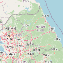
Map view of Bukhansan National Park

Use this park location map to pinpoint Bukhansan National Park in South Korea, understand its exact geographic position, and read its mapped placement within the surrounding landscape more clearly.

Pigeon | © OpenStreetMap contributors

Location context for Bukhansan National Park

Gyeonggi ProvinceSeoul
Park atlas

Explore surrounding landscapes and compare regional protected areas, tracing connections to Bukhansan's unique mountain terrain.

Discover Other National Parks and Protected Areas Near Bukhansan National Park
Browse a curated selection of national parks and protected areas located in proximity to Bukhansan National Park, offering diverse mountain terrain, forested slopes, and cultural heritage sites. Continue your atlas-style exploration to compare these distinct protected landscapes and understand their geographic context within the broader South Korean region.
National parkGangwon-do

Chiaksan National Park: National Park Protected Landscape and Geographic Context in Gangwon-do

Explore mapped boundaries and regional terrain.

Chiaksan National Park is a designated national park within South Korea's Gangwon-do region, offering a focused entry point for geographic discovery. This resource details the park's protected landscape, its mapped boundaries, and its relation to the surrounding natural terrain. Delve into the atlas-style context of Chiaksan National Park to understand its significance as a protected natural area within its regional geography.

Area
181.57 km²
Established
1984
IUCN
II
Relief
Mountain
National parkSouth Korea

Taean Seaside National Park: National Park Geography and Mapped Landscape Discovery

South Korea's protected coastal terrain.

Explore the precise geographic identity of Taean Seaside National Park, a key protected area within South Korea. This page offers an atlas-style perspective on its landscape context, mapped boundaries, and regional distribution across the Korean Peninsula. Understand its role as a national park and its contribution to the mapped natural terrain of East Asia.

Area
840 km²
Established
1978
IUCN
II
Relief
Lowland
National parkGangwon Province

Seoraksan National Park: A Protected Landscape Within Gangwon Province's Geography

Explore mapped boundaries and regional protected-area distribution.

Seoraksan National Park is a crucial protected area offering a unique lens into the natural landscapes of Gangwon Province. This national park serves as a key geographic anchor, detailed here with its mapped boundaries and regional context for comprehensive atlas exploration. Understand its role as a conservation landscape and discover its place within South Korea's protected lands.

Area
398.22 km²
Established
1970
IUCN
II
Relief
Mountain
National parkGangwon-do

Odaesan National Park: South Korea's Protected Landscape and Geographic Context in Gangwon-do

Explore the mapped boundaries and regional terrain of this national park.

Access detailed geographic information and atlas-style exploration for Odaesan National Park, a protected National Park located in Gangwon-do, South Korea. Understand its distinct landscape character and mapped boundaries, contributing to a broader understanding of protected areas within the regional geography. This resource is designed for users interested in the specific geographic identity and mapped context of individual park entities.

Area
303.93 km²
Established
1975
IUCN
II
Relief
Mountain
Watercolor illustration of green hills, a body of water, and mountain peaks under a soft sky
National parkGyeongsangbuk-do

Woraksan National Park: A Key National Park in Gyeongsangbuk-do's Regional Geography

Discover its mapped mountain terrain and protected landscape identity.

Woraksan National Park offers a detailed view of protected mountain landscapes within South Korea's Gyeongsangbuk-do region. The park is characterized by its prominent Mount Worak, steep ridgelines, and dense forested terrain, contributing significantly to the nation's network of protected areas. Users can explore the geographic context, mapped boundaries, and ecological significance of this vital national park, understanding its place in the broader regional atlas and natural landscape context.

Area
287.78 km²
Established
1984
IUCN
II
Relief
Mountain
National parkChungcheongnam-do

Gyeryongsan National Park: Mapped Protected Landscape in Chungcheongnam-do

Explore its national park designation and regional geography.

Gyeryongsan National Park is a formally protected national park in Chungcheongnam-do, South Korea. This page offers critical atlas context for understanding the park's geographic scope, mapped protected boundaries, and its significance as a natural landscape within the region. Examine the terrain and explore its regional context for a deeper appreciation of its protected status.

Area
64.71 km²
Established
1968
IUCN
II
Relief
Mountain
National parkSouth Korea

Songnisan National Park: Mapped Protected Landscape and Geographic Context in South Korea

Discover South Korea's Songnisan National Park and its protected terrain.

Delve into the protected landscape of Songnisan National Park, a key national park entity in South Korea. This atlas-focused view highlights its mapped geographic boundaries and natural terrain, providing essential context for understanding conservation areas. Explore Songnisan National Park as a distinct protected region contributing to the country's diverse geography and mapped natural heritage.

Area
274.541 km²
Established
1970
IUCN
II
Relief
Mountain
National parkChungcheongbuk-do

Sobaeksan National Park: A Protected Landscape within Chungcheongbuk-do

Explore its park boundaries and regional geography.

Sobaeksan National Park represents a crucial protected area within the mountainous terrain of Chungcheongbuk-do, South Korea. As a designated national park, it offers a valuable point of reference for understanding regional geographic distribution and landscape context across the Korean Peninsula. This park's identity as a protected natural landscape contributes significantly to the atlas-based exploration of conservation areas and their environmental settings.

Area
322.38 km²
Established
1987
IUCN
II
Relief
Mountain

Common questions about visiting, size, designation, and location context for Bukhansan National Park

Bukhansan National Park FAQs for park facts, access, geography, and protected area context
Find quick answers about Bukhansan National Park, including protected-area facts, park geography, trail and visitor context, and how the park fits into its surrounding country and regional landscape.
MoriAtlas Explorer

Continue Your Protected Areas Search Across the Global Atlas

Deepen your exploration by continuing the structured search for national parks and protected areas worldwide. Utilize the comprehensive filtering capabilities to compare different conservation landscapes and refine your understanding of global park geography. Discover more about the distribution and characteristics of protected natural areas.

Global natural geography