

Mori Atlas logo
National parkSeoraksan National Park

Discover the mapped boundaries and regional geography of this vital national park.

Seoraksan National Park: South Korea's Protected Landscape in Gangwon Province

Seoraksan National Park stands as a significant protected area, offering rich geographic context for exploration within Gangwon Province. This national park is integral to understanding the natural landscapes and mapped terrain of South Korea. MoriAtlas facilitates discovery of its protected boundaries and regional setting, providing essential data for those interested in detailed park geography and the atlas-scale distribution of conservation lands.

Alpine MountainsGranite PeaksUNESCO Biosphere ReserveOld-Growth ForestsWaterfall SystemsBuddhist Temples

Seoraksan National Park

National park

Park overview

Structured park overview, official facts, and landscape profile for Seoraksan National Park

Seoraksan National Park park facts, protected area profile, and essential visitor context
Review the core facts for Seoraksan National Park, including designation, size, terrain, visitor scale, habitats, and operating context in one park-focused overview.

About Seoraksan National Park

Seoraksan National Park represents the crown jewel of South Korea's protected area system, a mountainous wilderness that combines dramatic geological scenery with exceptional biological diversity and deep cultural heritage. The park spans approximately 398 square kilometers of terrain that forms part of the larger Baekdu mountain range running along the Korean peninsula's eastern spine. Visitors encounter a landscape of remarkable topographic diversity, where steep granite cliffs rise above forested slopes, mountain streams rush through narrow valleys, and exposed rock ridges offer sweeping views across the surrounding landscape. The area's ecological significance stems from its position within a transition zone between continental and maritime climate influences, supporting plant and animal species from both eastern Asian and Korean endemics. Beyond its natural values, Seoraksan holds profound cultural importance as the site of ancient Buddhist temples that have drawn pilgrims and scholars for centuries, creating a layered landscape where natural and spiritual heritage intertwine.

Quick facts and research context for Seoraksan National Park

Seoraksan National Park occupies a strategic position on the east-central Korean peninsula in Gangwon Province, serving as a critical protected area for the region's alpine ecosystems. The park was formally established on March 24, 1970 as South Korea's inaugural national park under the National Park Law, marking a pivotal moment in the country's conservation history. The terrain is characterized by ancient granite and gneiss formations that have been dramatically dissected by erosion, creating the park's distinctive sawtooth ridges and steep-walled valleys. Annual precipitation ranges from approximately 1,000 millimeters in the inner mountain zones to 1,300 millimeters in outer areas, with the majority falling during intense summer monsoon season and occasional typhoons. The Korea National Park Service manages the protected area, which has also held UNESCO biosphere reserve status since 1982, recognizing its global significance as a representative temperate forest ecosystem.

Park context

Deeper park guide and search-rich context for Seoraksan National Park

Seoraksan National Park history, landscape, wildlife, and travel context
Explore Seoraksan National Park through its history, landscape character, ecosystems, wildlife, conservation priorities, cultural context, and seasonal travel timing in a structured park guide built for atlas discovery and search intent.

Why Seoraksan National Park stands out

Seoraksan is best known for its spectacular alpine scenery characterized by towering granite peaks, dramatic rock formations such as Ulsanbawi and Heundeulbawi, and cascading waterfalls including Biryeong and Yukdam that plunge through forested canyons. The park's ecological diversity is equally significant, supporting one of Korea's richest assemblages of flora and fauna across its elevational gradient from valley hardwood forests to subalpine pine communities. The presence of endangered species including the Korean goral, Korean musk deer, and Tristram's woodpecker underscores the park's conservation importance. Cultural landmarks such as the Buddhist temples Baekdamsa and Sinheungsa, nestled in the mountain valleys, add historical depth to the natural landscape and reflect the area's long spiritual significance.

Seoraksan National Park history and protected-area timeline

The protection of Seoraksan's natural heritage began in 1965 when the South Korean government designated the area as a nature reserve, recognizing the need to preserve its outstanding landscapes and ecological values. This initial protection laid the foundation for the park's formal establishment as South Korea's first national park on March 24, 1970, when the National Park Law came into effect and Seoraksan was designated under this new legal framework. The significance of the area was further recognized internationally when UNESCO designated Seoraksan as a biosphere reserve in 1982, acknowledging its importance as a representative temperate forest ecosystem with global conservation value. In 1991, the park hosted the 17th World Jamboree, a major international scouting event that brought thousands of young people from around the world to the mountain slopes, highlighting Seoraksan's capacity to accommodate large-scale international gatherings while maintaining its natural character. The park continues to be managed by the Korea National Park Service, which works to balance visitor access with conservation objectives across this heavily used but ecologically resilient protected landscape.

Seoraksan National Park landscape and geographic character

The physical landscape of Seoraksan National Park is defined by its location within the Baekdu mountain system, a range of ancient crystalline mountains that form the backbone of the Korean peninsula's eastern edge. The park's terrain is dominated by massive granite and gneiss formations that have been shaped by millions of years of erosion, creating the characteristic sharp ridges, steep cliffs, and towering rock spires that define the mountain's visual character. The highest peak, Daecheongbong, rises to 1,708 meters above sea level, while numerous other summits exceed 1,200 meters, creating an alpine environment unusual for the Korean peninsula. Deep valleys radiate from the central peaks, funnelling water drainage toward the eastern coast and creating habitats ranging from riparian corridors to steep north-facing slopes. The interplay of hard crystalline rock with the region's strong seasonal precipitation, including heavy summer monsoon rains and occasional typhoons, has produced the dramatic scenery of waterfalls, rock shelters, and carved passages that attract visitors to the park.

Seoraksan National Park ecosystems, habitats, and plant life

Seoraksan's ecological character reflects the park's position within a biologically diverse region of the Korean peninsula, supporting approximately 1,013 documented plant species including 822 vascular plant species across its elevational and aspect gradients. The southern slopes feature abundant Siberian pine forests, while the northern aspects are characterized by oak-dominated deciduous woodland that transitions to mixed conifer-hardwood communities in the deeper valleys where Thuja trees thrive. Dwarf pine and yew communities occupy higher elevation zones, while juniper, hawthorn, and Manchurian fir add to the forest composition on exposed ridges and slopes. The understory supports diverse herbaceous plants including forsythias and saw-worts, while the rare endemic plant Hanabusaya asiatica represents one of the park's botanical treasures. This vegetation diversity supports a corresponding animal richness, with 1,562 animal species documented to date, including mammals, birds, fish, and invertebrates that occupy the park's varied habitats from valley streams to alpine rock fields.

Seoraksan National Park wildlife and species highlights

The wildlife community within Seoraksan includes both common species and several rare taxa that find refuge within the protected area's diverse habitats. Mammals such as otters and the Siberian flying squirrel inhabit the riparian corridors and forested valleys, while birds of prey including kestrels and Chinese sparrowhawks hunt along the mountain slopes. The stream systems support fish species including lenok, Chinese minnow, and spotted barbel that require the cold, well-oxygenated waters of the park's mountain rivers. The park holds particular significance for endangered species including Tristram's woodpecker, a bird associated with old-growth forest, the Korean goral, a mountain-dwelling goat-antelope, and the Korean musk deer, a small forest deer that inhabits the steep terrain of the park's forested slopes. These species benefit from the protection afforded by the national park status and the broader biosphere reserve designation, which maintains habitat connectivity across the larger landscape.

Seoraksan National Park conservation status and protection priorities

Seoraksan National Park serves as a flagship protected area for South Korea, representing both the country's first national park and one of its most significant conservation landscapes. The park's designation as a UNESCO biosphere reserve in 1982 reflects international recognition of its ecological values, while its tentative World Heritage status acknowledges the outstanding universal value of its natural and cultural attributes. The protected area provides critical habitat for several endangered species, including the Korean goral and Korean musk deer, both of which are considered threatened at the national level. Management by the Korea National Park Service focuses on maintaining ecological integrity while providing controlled access for education and appreciation, balancing the heavy visitor use that the park receives with the conservation of its sensitive alpine ecosystems and rare species populations.

Seoraksan National Park cultural meaning and human context

The natural landscape of Seoraksan has been shaped by centuries of human presence, with Buddhist temples providing the most visible cultural layer within the park's boundaries. Baekdamsa and Sinheungsa, two significant Buddhist temples, are nestled within the mountain valleys, their architecture and setting reflecting the traditional Korean practice of siting sacred structures in prominent natural locations. These temples have drawn pilgrims and practitioners for generations, creating spiritual pathways and cultural practices that are interwoven with the physical landscape. The mountain itself holds significance in Korean cultural tradition, viewed as a sacred space where natural and spiritual realms intersect. This cultural heritage adds depth to the park's conservation values, creating a destination where visitors can experience both the natural world and the accumulated spiritual and historical meanings embedded in the landscape.

Top sights and standout views in Seoraksan National Park

Seoraksan offers visitors an exceptional combination of dramatic mountain scenery, ecological diversity, and cultural heritage within a protected wilderness setting. The iconic rock formation of Ulsanbawi, with its towering granite spires, stands as the park's most recognizable landmark, while the waterfalls of Biryeong and Yukdam provide dramatic natural spectacles as they cascade through the forested valleys. Hiking trails traverse the full range of the park's terrain, from accessible valley walks to challenging ridge routes that reward visitors with sweeping panoramas from the high peaks. The presence of ancient Buddhist temples within the forest setting creates moments of cultural discovery along trails that also offer encounters with diverse wildlife and plant communities. The park's status as South Korea's first national park and a UNESCO biosphere reserve underscores its significance both nationally and internationally as a conservation model and wilderness preserve.

Best time to visit Seoraksan National Park

Seoraksan can be visited year-round, though each season offers distinctly different experiences of the park's character. Spring brings flowering plants to the lower elevations and comfortable temperatures for hiking, while summer, though hot and humid, offers the full force of the park's waterfalls and lush green forest cover. Autumn provides perhaps the most spectacular season, with the deciduous forests displaying vivid fall coloration across the slopes and clear weather typically providing excellent visibility from the high ridges. Winter transforms the landscape into a stark alpine environment, with snow cover on the peaks creating dramatic contrast against the dark rock formations and offering a different kind of wilderness experience for those who embrace the cold. The heavy summer rains that characterize the region can bring flooding to valleys, so visitors planning summer trips should be aware of the potential for rapid weather changes and the park's susceptibility to typhoon conditions during late summer.

Park location guide

Geography guide, regional context, and park location map for Seoraksan National Park

Seoraksan National Park park geography, regions, and map view in South Korea
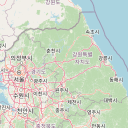
Understand where Seoraksan National Park sits in South Korea through a broader geographic reading of the surrounding landscape, nearby location context, and its mapped position within the national park landscape.

How Seoraksan National Park fits into South Korea

South Korea is a presidential republic on the Korean Peninsula in East Asia. It has a population of about 51 million and Seoul as its capital and largest city. The country is known for its rapid economic development, high technology industry, and cultural exports.

Wider geography shaping Seoraksan National Park in South Korea

South Korea occupies the southern half of the Korean Peninsula in East Asia. It borders North Korea along the Demilitarized Zone to the north, the Yellow Sea to the west, and the Sea of Japan to the east. The terrain is predominantly mountainous with coastal plains along the southern and eastern shores.

Map view of Seoraksan National Park

Use this park location map to pinpoint Seoraksan National Park in South Korea, understand its exact geographic position, and read its mapped placement within the surrounding landscape more clearly.

Pigeon | © OpenStreetMap contributors

Location context for Seoraksan National Park

Gangwon Province
Park atlas

Compare diverse mountain, forest, and coastal protected landscapes across the Korean peninsula.

Explore More National Parks and Protected Areas Near Seoraksan National Park
Discover a curated selection of other national parks and protected areas within the broader regional context of Seoraksan National Park, comparing their distinct geographical features and conservation profiles. Tracing these adjacent protected landscapes allows for a deeper atlas-style understanding of the regional park geography and ecological diversity across the Korean peninsula.
National parkGangwon-do

Odaesan National Park: South Korea's Protected Landscape and Geographic Context in Gangwon-do

Explore the mapped boundaries and regional terrain of this national park.

Access detailed geographic information and atlas-style exploration for Odaesan National Park, a protected National Park located in Gangwon-do, South Korea. Understand its distinct landscape character and mapped boundaries, contributing to a broader understanding of protected areas within the regional geography. This resource is designed for users interested in the specific geographic identity and mapped context of individual park entities.

Area
303.93 km²
Established
1975
IUCN
II
Relief
Mountain
National parkGangwon-do

Chiaksan National Park: National Park Protected Landscape and Geographic Context in Gangwon-do

Explore mapped boundaries and regional terrain.

Chiaksan National Park is a designated national park within South Korea's Gangwon-do region, offering a focused entry point for geographic discovery. This resource details the park's protected landscape, its mapped boundaries, and its relation to the surrounding natural terrain. Delve into the atlas-style context of Chiaksan National Park to understand its significance as a protected natural area within its regional geography.

Area
181.57 km²
Established
1984
IUCN
II
Relief
Mountain
National parkChungcheongbuk-do

Sobaeksan National Park: A Protected Landscape within Chungcheongbuk-do

Explore its park boundaries and regional geography.

Sobaeksan National Park represents a crucial protected area within the mountainous terrain of Chungcheongbuk-do, South Korea. As a designated national park, it offers a valuable point of reference for understanding regional geographic distribution and landscape context across the Korean Peninsula. This park's identity as a protected natural landscape contributes significantly to the atlas-based exploration of conservation areas and their environmental settings.

Area
322.38 km²
Established
1987
IUCN
II
Relief
Mountain
National parkGyeonggi Province

Bukhansan National Park: Protected Area Geography and Mapped Boundaries in Gyeonggi Province

Explore the landscape context of this national park.

Bukhansan National Park stands as a distinct protected area within Gyeonggi Province, offering a rich landscape for geographic exploration. This entry focuses on its identity as a national park, detailing its mapped boundaries and its contribution to the regional geography. Users can explore its protected landscape features and understand its significance through a structured, map-centric approach, enriching their atlas understanding of protected natural areas.

Area
79.92 km²
Established
1983
IUCN
II
Visitors
5M annual
Watercolor illustration of green hills, a body of water, and mountain peaks under a soft sky
National parkGyeongsangbuk-do

Woraksan National Park: A Key National Park in Gyeongsangbuk-do's Regional Geography

Discover its mapped mountain terrain and protected landscape identity.

Woraksan National Park offers a detailed view of protected mountain landscapes within South Korea's Gyeongsangbuk-do region. The park is characterized by its prominent Mount Worak, steep ridgelines, and dense forested terrain, contributing significantly to the nation's network of protected areas. Users can explore the geographic context, mapped boundaries, and ecological significance of this vital national park, understanding its place in the broader regional atlas and natural landscape context.

Area
287.78 km²
Established
1984
IUCN
II
Relief
Mountain
National parkSouth Korea

Songnisan National Park: Mapped Protected Landscape and Geographic Context in South Korea

Discover South Korea's Songnisan National Park and its protected terrain.

Delve into the protected landscape of Songnisan National Park, a key national park entity in South Korea. This atlas-focused view highlights its mapped geographic boundaries and natural terrain, providing essential context for understanding conservation areas. Explore Songnisan National Park as a distinct protected region contributing to the country's diverse geography and mapped natural heritage.

Area
274.541 km²
Established
1970
IUCN
II
Relief
Mountain
National parkSouth Korea

Juwangsan National Park: Protected Mountain Landscape and Regional Geography in South Korea

Mapped terrain, park boundaries, and natural landscapes.

Juwangsan National Park is a protected natural area situated within South Korea's Taebaek mountain range, renowned for its steep valleys, waterfalls, and dense forests. This park offers a rich landscape context, showcasing dramatic ridgelines and providing a significant example of South Korea's protected mountain terrain. Discover its geographic placement, mapped protected boundaries, and the unique natural and cultural elements that define this national park.

Area
107.42 km²
Established
1976
IUCN
II
Relief
Mountain
National parkChungcheongnam-do

Gyeryongsan National Park: Mapped Protected Landscape in Chungcheongnam-do

Explore its national park designation and regional geography.

Gyeryongsan National Park is a formally protected national park in Chungcheongnam-do, South Korea. This page offers critical atlas context for understanding the park's geographic scope, mapped protected boundaries, and its significance as a natural landscape within the region. Examine the terrain and explore its regional context for a deeper appreciation of its protected status.

Area
64.71 km²
Established
1968
IUCN
II
Relief
Mountain

Common questions about visiting, size, designation, and location context for Seoraksan National Park

Seoraksan National Park FAQs for park facts, access, geography, and protected area context
Find quick answers about Seoraksan National Park, including protected-area facts, park geography, trail and visitor context, and how the park fits into its surrounding country and regional landscape.
MoriAtlas Explorer

Continue Your Protected Areas Search Across the Global Atlas

Deepen your exploration by continuing the structured search for national parks and protected areas worldwide. Utilize the comprehensive filtering capabilities to compare different conservation landscapes and refine your understanding of global park geography. Discover more about the distribution and characteristics of protected natural areas.

Global natural geography