

Mori Atlas logo
National parkSobaeksan National Park

Discover the mapped boundaries and regional geography of this key national park.

Sobaeksan National Park: South Korea's Protected Landscape in Chungcheongbuk-do

(소백산국립공원 (Sobaeksan National Park))

Sobaeksan National Park stands as a significant protected area within South Korea's Chungcheongbuk-do province. Situated in the mountainous landscape of the Korean Peninsula, this national park offers a rich context for understanding regional geography and mapped natural environments. Explore its protected landscape to gain insights into the distribution of conservation areas and the unique terrain that defines this vital part of the Hoseo region.

mountain national parkbiodiversity hotspotKorean Fox conservationtemperate forest ecosystemBaekdu-daegan corridorSouth Korean national park

Sobaeksan National Park

National park

Park overview

Structured park overview, official facts, and landscape profile for Sobaeksan National Park

Sobaeksan National Park park facts, protected area profile, and essential visitor context
Review the core facts for Sobaeksan National Park, including designation, size, terrain, visitor scale, habitats, and operating context in one park-focused overview.

About Sobaeksan National Park

Sobaeksan National Park occupies a strategic position in central-eastern South Korea, protecting a mountain range that forms part of the broader Baekdu-daegan mountain spine that runs down the Korean Peninsula. The park's terrain consists of steep ridges, rocky outcrops, and forested valleys that create varied microhabitats throughout its extent. The name Sobaeksan translates to "Small White Mountain," referring to the often snow-capped peaks that distinguish the range during winter months. The park serves as an important ecological corridor connecting protected areas in the region and provides watershed protection for communities in the surrounding provinces. Visitor facilities include trail systems that access key scenic areas while minimizing ecological impact, and the park maintains educational programs about its natural and cultural heritage.

Quick facts and research context for Sobaeksan National Park

Sobaeksan National Park covers 322.38 square kilometers of mountainous terrain in central South Korea, straddling the border between Chungcheongbuk-do and Gyeongsangbuk-do provinces. The park was established on December 14, 1987 as the 18th of South Korea's national parks. The park is named after Sobaeksan, a prominent mountain peak reaching 1,439 meters above sea level. The protected area is managed by the Korea National Park Service under IUCN Category II designation.

Park context

Deeper park guide and search-rich context for Sobaeksan National Park

Sobaeksan National Park history, landscape, wildlife, and travel context
Explore Sobaeksan National Park through its history, landscape character, ecosystems, wildlife, conservation priorities, cultural context, and seasonal travel timing in a structured park guide built for atlas discovery and search intent.

Why Sobaeksan National Park stands out

Sobaeksan National Park is best known for its mountainous forest ecosystem and its pioneering Korean Fox reintroduction program, one of South Korea's most visible wildlife conservation initiatives. The park's diverse altitudinal zones support a wide range of habitats from valley forests to subalpine environments, creating favorable conditions for remarkable biodiversity. The landscape is characterized by rugged peaks, forested slopes, and seasonal wildflower displays that draw visitors throughout the year.

Sobaeksan National Park history and protected-area timeline

Sobaeksan National Park was designated as South Korea's 18th national park on December 14, 1987, representing a continuation of the nation's efforts to preserve representative examples of its natural landscapes. The establishment came during a period of expanded conservation activity in South Korea, as the national park system matured to include diverse ecosystem types beyond the initial focus on iconic peaks. The Korean Fox reintroduction program represents one of the park's most significant conservation milestones, beginning with the capture of individuals for captive breeding and subsequently releasing offspring to establish a wild population. This program reflects South Korea's broader commitment to recovering native species that have been pushed to the brink of extinction by habitat loss and historical hunting pressure.

Sobaeksan National Park landscape and geographic character

The park's landscape is defined by the Sobaeksan mountain range, with the principal peak rising 1,439 meters above sea level. The terrain consists of steep-sided valleys, rocky ridgelines, and interspersed plateaus that create a dramatic mountain environment. Forest cover dominates the lower and mid-elevation slopes, transitioning to shrubland and alpine vegetation near the summit. The park's geology contributes to the formation of distinctive rock formations and cliff faces that add visual interest to the landscape. Seasonal transformations are pronounced, with spring bringing blossoming rhododendrons and wildflowers, summer offering lush green forests, autumn displaying vibrant foliage colors, and winter covering the peaks in snow.

Sobaeksan National Park ecosystems, habitats, and plant life

Sobaeksan National Park protects a rich mosaic of habitats resulting from its elevation range and position in central Korea. The forest ecosystem includes both deciduous and coniferous species, with oak, maple, and pine communities prevalent throughout the park. The park's biodiversity figures are substantial, with 1,067 plant species and 2,639 animal species documented within its boundaries. These numbers reflect the park's role as a significant repository of Korean flora and fauna. The altitudinal gradient creates distinct ecological zones, from warm-temperate forests in the lower elevations through cool-temperate zones to subalpine conditions near the peaks, supporting different species assemblages at each level.

Sobaeksan National Park wildlife and species highlights

The park's animal community includes 2,639 documented species, representing significant biodiversity for a mountain protected area in South Korea. The Korean Fox reintroduction program stands as the park's most prominent wildlife initiative, aiming to establish a viable population of approximately 50 individuals through the release of captive-bred animals. This critically endangered canid was once widespread across the Korean Peninsula but suffered severe population declines due to habitat destruction and historical trapping. Beyond the fox program, the park supports diverse mammal, bird, reptile, amphibian, and insect communities that benefit from the protected habitat. The forest environment provides crucial foraging and shelter areas for numerous species.

Sobaeksan National Park conservation status and protection priorities

Sobaeksan National Park serves as an important conservation unit within South Korea's protected area network, safeguarding both biodiversity and watershed values. The Korean Fox reintroduction program represents a targeted species recovery effort that has drawn international attention as a model for recovering critically endangered Korean fauna. The park's 1987 designation provided formal protection for the mountain ecosystem and the species it supports, enabling management actions that would be impossible without protected area status. The Korea National Park Service manages the park with responsibilities including visitor management, resource protection, and ongoing monitoring of key species populations.

Sobaeksan National Park cultural meaning and human context

The mountain has traditional significance in Korean culture as part of the spiritual landscape, though the park's primary focus is on natural rather than cultural heritage preservation. The Korean place name and its Hanja characters reflect historical naming conventions that describe the mountain's visual characteristics. Communities in the surrounding provinces have historical connections to the mountain landscape that predate the national park designation, though the protected area status has changed land-use patterns in the region.

Top sights and standout views in Sobaeksan National Park

The Korean Fox reintroduction program distinguishes Sobaeksan as one of South Korea's most active wildlife recovery sites. The 1,439-meter Sobaeksan peak provides a scenic goal for hikers, with trail systems offering access to panoramic viewpoints. The park's seasonal variation creates different appeals throughout the year, from spring wildflower blooms to autumn foliage colors to winter snowscapes. The biodiversity figures of over 1,000 plant species and 2,600 animal species indicate substantial ecological value within the park's boundaries.

Best time to visit Sobaeksan National Park

Sobaeksan National Park offers year-round visitation opportunities, though different seasons provide distinct experiences. Spring and autumn generally offer comfortable temperatures for hiking and the most visually appealing conditions, with spring wildflowers and autumn foliage enhancing the landscape. Summer brings warmer conditions but provides opportunities to see wildlife in the lush forest environment. Winter offers a different character with snow-covered peaks and fewer visitors, though trail conditions may be more challenging. The best time depends on visitor priorities, whether seeking comfortable hiking conditions, specific seasonal scenery, or wildlife observation opportunities.

Park location guide

Geography guide, regional context, and park location map for Sobaeksan National Park

Sobaeksan National Park park geography, regions, and map view in South Korea
Understand where Sobaeksan National Park sits in South Korea through a broader geographic reading of the surrounding landscape, nearby location context, and its mapped position within the national park landscape.

How Sobaeksan National Park fits into South Korea

South Korea is a presidential republic on the Korean Peninsula in East Asia. It has a population of about 51 million and Seoul as its capital and largest city. The country is known for its rapid economic development, high technology industry, and cultural exports.

Wider geography shaping Sobaeksan National Park in South Korea

South Korea occupies the southern half of the Korean Peninsula in East Asia. It borders North Korea along the Demilitarized Zone to the north, the Yellow Sea to the west, and the Sea of Japan to the east. The terrain is predominantly mountainous with coastal plains along the southern and eastern shores.

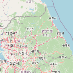
Map view of Sobaeksan National Park

Use this park location map to pinpoint Sobaeksan National Park in South Korea, understand its exact geographic position, and read its mapped placement within the surrounding landscape more clearly.

Pigeon | © OpenStreetMap contributors

Location context for Sobaeksan National Park

Chungcheongbuk-doGyeongsangbuk-do
Park atlas

Trace the Geographic Spread of South Korea's Mountain Protected Areas Beyond Sobaeksan's Peaks

Discover Other National Parks and Protected Areas Near Sobaeksan National Park, South Korea
Explore a curated list of national parks and other protected areas contextually adjacent to Sobaeksan National Park, tracing South Korea's significant conservation landscapes and mountain ecosystems. Compare diverse protected regions across the peninsula, understanding their unique geographic characteristics and ecological contributions for deeper atlas-style discovery.
Watercolor illustration of green hills, a body of water, and mountain peaks under a soft sky
National parkGyeongsangbuk-do

Woraksan National Park: A Key National Park in Gyeongsangbuk-do's Regional Geography

Discover its mapped mountain terrain and protected landscape identity.

Woraksan National Park offers a detailed view of protected mountain landscapes within South Korea's Gyeongsangbuk-do region. The park is characterized by its prominent Mount Worak, steep ridgelines, and dense forested terrain, contributing significantly to the nation's network of protected areas. Users can explore the geographic context, mapped boundaries, and ecological significance of this vital national park, understanding its place in the broader regional atlas and natural landscape context.

Area
287.78 km²
Established
1984
IUCN
II
Relief
Mountain
National parkGangwon-do

Chiaksan National Park: National Park Protected Landscape and Geographic Context in Gangwon-do

Explore mapped boundaries and regional terrain.

Chiaksan National Park is a designated national park within South Korea's Gangwon-do region, offering a focused entry point for geographic discovery. This resource details the park's protected landscape, its mapped boundaries, and its relation to the surrounding natural terrain. Delve into the atlas-style context of Chiaksan National Park to understand its significance as a protected natural area within its regional geography.

Area
181.57 km²
Established
1984
IUCN
II
Relief
Mountain
National parkSouth Korea

Songnisan National Park: Mapped Protected Landscape and Geographic Context in South Korea

Discover South Korea's Songnisan National Park and its protected terrain.

Delve into the protected landscape of Songnisan National Park, a key national park entity in South Korea. This atlas-focused view highlights its mapped geographic boundaries and natural terrain, providing essential context for understanding conservation areas. Explore Songnisan National Park as a distinct protected region contributing to the country's diverse geography and mapped natural heritage.

Area
274.541 km²
Established
1970
IUCN
II
Relief
Mountain
National parkSouth Korea

Juwangsan National Park: Protected Mountain Landscape and Regional Geography in South Korea

Mapped terrain, park boundaries, and natural landscapes.

Juwangsan National Park is a protected natural area situated within South Korea's Taebaek mountain range, renowned for its steep valleys, waterfalls, and dense forests. This park offers a rich landscape context, showcasing dramatic ridgelines and providing a significant example of South Korea's protected mountain terrain. Discover its geographic placement, mapped protected boundaries, and the unique natural and cultural elements that define this national park.

Area
107.42 km²
Established
1976
IUCN
II
Relief
Mountain
National parkGangwon-do

Odaesan National Park: South Korea's Protected Landscape and Geographic Context in Gangwon-do

Explore the mapped boundaries and regional terrain of this national park.

Access detailed geographic information and atlas-style exploration for Odaesan National Park, a protected National Park located in Gangwon-do, South Korea. Understand its distinct landscape character and mapped boundaries, contributing to a broader understanding of protected areas within the regional geography. This resource is designed for users interested in the specific geographic identity and mapped context of individual park entities.

Area
303.93 km²
Established
1975
IUCN
II
Relief
Mountain
National parkGangwon Province

Seoraksan National Park: A Protected Landscape Within Gangwon Province's Geography

Explore mapped boundaries and regional protected-area distribution.

Seoraksan National Park is a crucial protected area offering a unique lens into the natural landscapes of Gangwon Province. This national park serves as a key geographic anchor, detailed here with its mapped boundaries and regional context for comprehensive atlas exploration. Understand its role as a conservation landscape and discover its place within South Korea's protected lands.

Area
398.22 km²
Established
1970
IUCN
II
Relief
Mountain
National parkSouth Gyeongsang Province

Gayasan National Park: National Park Identity and Mapped Geographic Context in South Korea

Discover Protected Landscape and Regional Terrain

Gayasan National Park presents a distinct protected-area entity within South Gyeongsang Province, serving as a crucial point for atlas-driven geographic exploration. As a designated national park in South Korea, it offers insights into its specific mapped boundaries and the surrounding natural terrain. Understanding this park's role within the regional geography provides a foundational element for comprehending broader landscape patterns and protected land distribution across the country.

Area
167.6 km²
Established
1972
IUCN
II
Relief
Mountain
National parkChungcheongnam-do

Gyeryongsan National Park: Mapped Protected Landscape in Chungcheongnam-do

Explore its national park designation and regional geography.

Gyeryongsan National Park is a formally protected national park in Chungcheongnam-do, South Korea. This page offers critical atlas context for understanding the park's geographic scope, mapped protected boundaries, and its significance as a natural landscape within the region. Examine the terrain and explore its regional context for a deeper appreciation of its protected status.

Area
64.71 km²
Established
1968
IUCN
II
Relief
Mountain

Common questions about visiting, size, designation, and location context for Sobaeksan National Park

Sobaeksan National Park FAQs for park facts, access, geography, and protected area context
Find quick answers about Sobaeksan National Park, including protected-area facts, park geography, trail and visitor context, and how the park fits into its surrounding country and regional landscape.
MoriAtlas Explorer

Continue Your Protected Areas Search Across the Global Atlas

Deepen your exploration by continuing the structured search for national parks and protected areas worldwide. Utilize the comprehensive filtering capabilities to compare different conservation landscapes and refine your understanding of global park geography. Discover more about the distribution and characteristics of protected natural areas.

Global natural geography