Mori Atlas logo
National parkBurren National Park

Explore the unique karst landscape and mapped geographic boundaries of this protected area.

Burren National Park: Protected National Park in County Clare, Ireland

Burren National Park represents a distinct protected landscape within County Clare, Ireland, a region known for its dramatic Atlantic coast and unique karst terrain. This page offers an atlas-driven exploration of the park's national park status, helping you understand its geographic setting, mapped boundaries, and place within the natural context of the Burren region. Discover the structured geographic information that defines this significant protected area.

Karst landscapeLimestone pavementWestern IrelandCounty ClareKarst geologyProtected area

Burren National Park

National park

Park overview

Structured park overview, official facts, and landscape profile for Burren National Park

Burren National Park park facts, protected area profile, and essential visitor context
Review the core facts for Burren National Park, including designation, size, terrain, visitor scale, habitats, and operating context in one park-focused overview.

About Burren National Park

Burren National Park preserves one of Ireland's most unusual and scientifically significant landscapes within a relatively small protected area. Located in the west of Ireland in County Clare, the park forms part of a larger region known as The Burren, a name derived from the Irish word "boirne" meaning a rocky place. The landscape is fundamentally defined by its carbonate limestone bedrock, which has been carved by glacial and karst processes into the characteristic terrain of pavement, fissures, sinkholes, and underground drainage systems that visitors encounter today.

The geological character of the park dates back approximately 350 million years when the region lay beneath a tropical sea. The limestone deposits that formed during this period have since been uplifted, glaciated, and dissected to create the terrain that now exists. The park's elevation ranges across mountainous terrain, with summits offering panoramic views over the karst plains below. The interaction between the limestone geology and the local climate has produced a landscape where surface water quickly disappears into sinkholes, flowing underground before emerging in springs or disappearing streams elsewhere in the landscape.

Despite its rocky appearance, the park supports a surprising diversity of habitats and species. The combination of altitude, exposure, soil depth, and moisture levels creates a mosaic of conditions that allows plants with vastly different ecological requirements to grow in close proximity. This botanical peculiarity has made The Burren the subject of extensive botanical research and remains a central reason for the area's protected status.

Quick facts and research context for Burren National Park

Burren National Park is located in County Clare, Ireland, approximately 15 kilometers northeast of Ennis, the nearest major town. The park was formally established in 1991 and remains the smallest of Ireland's eight national parks, covering roughly 15 square kilometers. It is managed by the National Parks and Wildlife Service under IUCN category II protection. The defining geological feature of the park is its karst landscape, characterized by limestone pavement, sinkholes, disappearing streams, and cave systems formed over millions of years. The park sits at approximately 53°01′N latitude and 9°00′W longitude.

Park context

Deeper park guide and search-rich context for Burren National Park

Burren National Park history, landscape, wildlife, and travel context
Explore Burren National Park through its history, landscape character, ecosystems, wildlife, conservation priorities, cultural context, and seasonal travel timing in a structured park guide built for atlas discovery and search intent.

Why Burren National Park stands out

Burren National Park is best known for its extraordinary karst landscape, one of the finest examples of karst terrain in Ireland and a site of significant geological interest. The limestone pavement, with its distinctive clints and grikes, represents a rare glacial relic shaped during the last Ice Age. The park also protects a unique ecological environment where Arctic-alpine and Mediterranean plant species coexist in an unusual botanical combination, a feature that distinguishes the Burren from other protected landscapes in Western Europe. The visual character of the terrain, with its stark exposed limestone, hidden valleys, and mosaic of habitats, makes it one of Ireland's most visually distinctive protected areas.

Burren National Park history and protected-area timeline

Burren National Park was established in 1991 when the Irish government designated a portion of The Burren region for national park status. The creation of the park reflected growing recognition of the region's unique geological and ecological significance within Ireland's protected area network. Prior to national park designation, the land had been subject to varying forms of protection and management, though the formal establishment of Burren National Park consolidated conservation efforts under the National Parks and Wildlife Service framework.

The establishment of the park came during a period when Ireland was expanding its network of protected areas, with the Burren representing a landscape type that had not previously been adequately represented in the national park system. The selection of this particular area for protection acknowledged both its scientific importance and its cultural heritage, as the Burren landscape has been shaped by human activity over millennia, including evidence of prehistoric settlement and agricultural use that has influenced the terrain's current character.

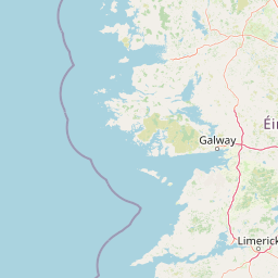
Burren National Park landscape and geographic character

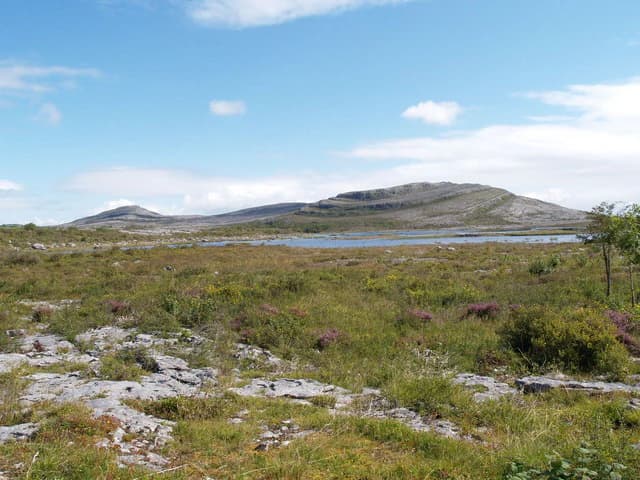
The landscape of Burren National Park is dominated by karst terrain resulting from the dissolution of limestone bedrock by acidic rainwater. The most striking feature is the limestone pavement, a terrain of flat, exposed rock broken into blocks known as clints, separated by fissures called grikes. This pavement results from the weathering and removal of soil cover that once overlay the limestone, exposing the bedrock surface. The depth and pattern of grikes vary across the park, creating a distinctive texture visible across the landscape.

Within this rocky terrain, visitors encounter a complex topography of hills, valleys, and depressions. The underlying cave systems and solutional features mean that the surface landscape is closely linked to subsurface hydrology. Streams that appear on the surface may suddenly disappear into swallow holes, flowing underground before emerging elsewhere. The park includes areas of blanket bog, heath vegetation, and grassland, with the distribution of these habitats reflecting local variations in soil depth, drainage, and exposure. The visual impression is of a stark, sculptural landscape where bare limestone alternates with pockets of vegetation in a pattern that distinguishes The Burren from any other landscape in Ireland.

Burren National Park ecosystems, habitats, and plant life

The ecological character of Burren National Park is defined by the interaction between the karst geology and the local climate, producing habitat conditions that support an unusual assemblage of plant species. The Burren is renowned among botanists for supporting species that typically occur in widely separated climatic zones. Arctic-alpine plants such as mountain avens and dwarf gentian grow alongside Mediterranean species including spring gentian and pyramidal orchid, all within the same landscape.

The habitat types within the park include calcareous grassland, heath communities, and patches of blanket bog. The grassland areas, where soil has accumulated in grikes and hollows, support a diverse flora including many rare and locally distributed species. The heath vegetation occurs on deeper soils and on north-facing slopes where moisture is retained longer. The mosaic of habitat types, combined with the microclimatic effects created by the limestone terrain, results in an ecological complexity far exceeding what might be expected from such a seemingly inhospitable landscape. This botanical diversity represents one of the park's most significant natural values and a primary justification for its protection.

Burren National Park wildlife and species highlights

The wildlife of Burren National Park reflects the park's position in western Ireland and the diversity of habitats present within its boundaries. The limestone grasslands and heath communities support populations of small mammals that in turn provide prey for raptors and other predatory birds. The park's location along the west coast of Ireland places it within important bird migration routes, with various species using the area as a seasonal habitat.

The cave systems and karst features provide sheltered habitats for several species associated with underground environments. The traditional farmland surrounding the park, and the patterns of pastoral use that have shaped the landscape over centuries, also contribute to the overall wildlife value of the broader Burren region. While the park is not primarily known for large mammalian species, the invertebrate fauna of the limestone grasslands is of particular interest, with several species of concern occurring in the area due to the specific habitat conditions the karst terrain provides.

Burren National Park conservation status and protection priorities

Burren National Park was established to protect a landscape and ecological system that is both nationally and internationally significant. The karst landscape represents a rare habitat type in Ireland and Western Europe, and its preservation ensures that the geological and ecological processes that shape this terrain continue to function within a protected context. The botanical significance of The Burren, with its unique combination of plant species from different climatic zones, has been recognized as a matter of conservation importance for many decades.

The management of the park involves maintaining the conditions that support its ecological and geological values while allowing for appropriate public access and enjoyment. This includes managing vegetation to prevent succession that would obscure the limestone pavement, and maintaining the traditional pastoral patterns that have helped shape the current landscape character. The park exists within a broader context of landscape conservation in the Burren region, where various initiatives have worked to balance agricultural use, conservation, and tourism in ways that sustain the features that make the area distinctive.

Burren National Park cultural meaning and human context

The Burren landscape has been shaped by human activity over several millennia, with evidence of prehistoric settlement in the region dating back to the Neolithic period. The landscape's current character reflects centuries of pastoral use, with the distinctive limestone walls that divide the terrain serving as evidence of field systems that have been maintained and modified over generations. These walls, constructed from locally gathered stones, are integral to the visual identity of the Burren and represent a traditional approach to land division and livestock management.

The region has also been significant in Irish cultural and religious history, with early monastic settlements established in the area during the early medieval period. The interaction between human communities and this challenging landscape has produced a cultural heritage that is deeply interwoven with the physical environment. The maintenance of traditional land use practices, particularly the seasonal grazing patterns that have been practiced in the Burren for generations, continues to influence the ecological character of the area and represents a form of cultural landscape management that has shaped the park's present appearance.

Top sights and standout views in Burren National Park

The limestone pavement of Burren National Park stands as the park's most visually striking feature, a landscape of international geological significance that offers visitors a glimpse into natural processes operating over millions of years. The unusual combination of Arctic-alpine and Mediterranean plant species growing in close proximity represents a botanical phenomenon that distinguishes The Burren from any other landscape in Ireland. The park's compact size makes it accessible for exploration while preserving a landscape of considerable scientific and aesthetic value. The panoramic views from the park's higher ground across the karst terrain below provide one of Ireland's most distinctive wilderness experiences.

Best time to visit Burren National Park

The Burren can be appreciated throughout the year, with each season offering a different perspective on the landscape. Spring and early summer bring the flowering of the park's distinctive flora, with the BotanicalGarden and herb-rich grasslands reaching their peak during May and June. The weather during these months can be variable, with showery conditions common but also periods of clear skies and warm sunshine that allow for extended exploration. Autumn offers a different character, with the heath and bog vegetation taking on autumnal colors and the landscape generally quieter as peak visitor season draws to a close. Winter, while often wet and windy, can reveal the landscape in stark simplicity, with the bare limestone at its most dramatic under overcast skies or when occasional snow dusts the higher ground.

Park location guide

Geography guide, regional context, and park location map for Burren National Park

Burren National Park park geography, regions, and map view in Ireland
Understand where Burren National Park sits in Ireland through a broader geographic reading of the surrounding landscape, nearby location context, and its mapped position within the national park landscape.

How Burren National Park fits into Ireland

Ireland is an island in the North Atlantic, geologically part of the British Isles. Politically, the island is split between the Republic of Ireland (a sovereign state and EU member) and Northern Ireland (part of the UK). The island has a population of approximately 7.2 million people and is known for its lush landscape, Celtic heritage, and literary culture.

Wider geography shaping Burren National Park in Ireland

Ireland is an island in the North Atlantic Ocean, separated from Great Britain to the east by the North Channel, Irish Sea, and St George's Channel. The island forms part of the British Isles archipelago. The terrain consists of low-lying mountains surrounding a central plain, with the highest point being Carrauntoohil at 1,041 metres. The coastline stretches approximately 7,527 kilometres with numerous inlets and bays.

Map view of Burren National Park

Use this park location map to pinpoint Burren National Park in Ireland, understand its exact geographic position, and read its mapped placement within the surrounding landscape more clearly.

Pigeon | © OpenStreetMap contributors

Location context for Burren National Park

County Clare
Park atlas

Trace diverse protected landscapes across County Clare and Western Ireland, comparing the unique karst geography.

Explore Related National Parks and Protected Areas Near Burren National Park, County Clare
Browse other national parks and protected areas geographically connected to Burren National Park, extending your discovery across County Clare and surrounding Western Ireland. This curated selection allows you to compare diverse landscapes, from unique karst formations to coastal reserves, enhancing your atlas exploration of Ireland's conservation efforts.
Stylized illustration of mountainous landscape with colorful terrain, valley, and winding path under a partly cloudy sky
National parkCounty Galway

Connemara National Park: A Mapped Protected Landscape in County Galway

Explore national park geography and protected terrain details.

Delve into Connemara National Park, a distinct national park located in the western region of County Galway, Ireland. This entry serves as a gateway to understanding its protected landscape, mapped boundaries, and its role within the broader geographic context of Connacht. Explore how this protected area contributes to the diverse natural terrain of Ireland, viewed through an atlas-driven discovery lens.

Area
20 km²
Established
1980
IUCN
II
Relief
Mountain
Watercolor illustration of a coastal landscape with green fields and distant mountains.
National parkCounty Kerry

Páirc Náisiúnta na Mara National Park: Protected Landscape Atlas for County Kerry

Explore mapped protected areas and regional geography.

This entry details Páirc Náisiúnta na Mara National Park, offering insights into its protected landscape character and geographic setting within County Kerry. As a significant protected area, it contributes to the atlas of Southwest Ireland, providing context for its natural terrain and mapped boundaries. Discover the park's unique identity and its position within the broader regional geography for structured exploration.

Area
280 km²
Established
2024
Relief
Mixed relief
Climate
Temperate
National park

Killarney National Park: A Protected Landscape for Geographic Exploration

Explore mapped boundaries and regional atlas context.

Killarney National Park is a significant protected area in Ireland, recognized as a national park for its unique natural attributes. MoriAtlas provides detailed mapping and geographic data to explore this protected landscape. Users can engage with the park's specific terrain, understand its mapped perimeters, and gain insights into its regional geographic significance, enhancing their overall atlas exploration experience.

Area
102.89 km²
Established
1932
IUCN
II
Relief
Mountain
National parkCounty Mayo

Wild Nephin National Park: Ireland's Protected Landscape in County Mayo

National Park with regional geographic context.

Explore Wild Nephin National Park, a significant protected area situated in County Mayo, Ireland. This entry focuses on the park's mapped boundaries and its unique natural terrain, offering a clear geographic perspective. Understand how this national park contributes to the diverse landscapes of western Ireland and serves as a key point for atlas-based discovery of protected lands.

Area
150 km²
Established
1998
IUCN
II
Climate
Temperate
Watercolor illustration of a landscape with mountains, a lake, and trees
National parkCounty Wicklow

Wicklow Mountains National Park: Protected Landscape and Geographic Atlas Mapping

Explore County Wicklow's mapped natural terrain and park boundaries.

Understand the geographic scope and protected landscape identity of Wicklow Mountains National Park. This page offers detailed information on its mapped boundaries and its context within County Wicklow, providing a foundation for atlas-based discovery of Ireland's natural areas. Explore how this national park contributes to the region's mapped geography and conservation landscapes.

Area
205 km²
Established
1991
IUCN
II
Relief
Mountain
National parkCounty Donegal

Glenveagh National Park: A Protected Landscape in the Heart of County Donegal

Mapped geography and natural terrain for Ireland's national park.

Delve into the geographic specifics of Glenveagh National Park, a protected area situated in County Donegal. This section provides detailed information on its mapped boundaries and regional landscape context. Understand how this national park fits within the natural geography of Ulster, offering a structured atlas view for detailed exploration of its unique terrain and protected status.

Area
169.58 km²
Established
1986
IUCN
II
Relief
Mixed relief
National parkPembrokeshire

Pembrokeshire Coast National Park: Mapped Coastal Boundaries and Protected Landscape Atlas

Explore unique seaside terrain and regional geography.

Delve into the Pembrokeshire Coast National Park, a premier protected landscape recognized for its extraordinary coastal formations and diverse natural terrain. This atlas entry details the park's distinct mapped boundaries, from its iconic limestone cliffs and sea stacks to its sheltered estuaries and inland Preseli Hills. Understand how this significant national park contributes to the protected area map of Pembrokeshire and offers unparalleled opportunities for geographic discovery along the Welsh coast.

Area
629 km²
Established
1952
IUCN
V
Relief
Mixed relief
National parkWales

Snowdonia National Park: Protected Landscape and Map Exploration in North Wales

Mountain terrain, glacial lakes, and regional geography.

Snowdonia National Park offers a profound exploration of mountainous protected landscapes in North Wales. This page details the park's mapped boundaries, revealing a terrain shaped by glaciation, featuring dramatic peaks like Snowdon, steep valleys, and pristine glacial lakes. Understand its geographic identity within the United Kingdom and how its protected status contributes to the regional landscape context, providing a unique focus for atlas-based discovery.

Area
2,142 km²
Established
1951
Relief
Mountain
Climate
Temperate

Common questions about visiting, size, designation, and location context for Burren National Park

Burren National Park FAQs for park facts, access, geography, and protected area context
Find quick answers about Burren National Park, including protected-area facts, park geography, trail and visitor context, and how the park fits into its surrounding country and regional landscape.
MoriAtlas Explorer

Continue Your Protected Areas Search Across the Global Atlas

Deepen your exploration by continuing the structured search for national parks and protected areas worldwide. Utilize the comprehensive filtering capabilities to compare different conservation landscapes and refine your understanding of global park geography. Discover more about the distribution and characteristics of protected natural areas.

Global natural geography