
Cave entrances
Park geography
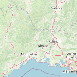
Analyzing the terrain elevation, regional context, and landscape features of this protected region.
Comprehensive Geographic Profile and Mapped Boundaries of Cévennes National Park in France
Cévennes National Park spans 937 square kilometers across the French regions of Occitanie, Aveyron, Ardèche, Lozère, and Gard. This geography profile details the diverse mountain, plateau, and forest terrain which reaches a maximum elevation of 1699 meters at Mont Aigoual, while maintaining a minimum elevation of 117 meters.
France's unique mid-mountain national park with Mediterranean landscapes, living cultural heritage, and exceptional biodiversity
Cévennes National Park
Cévennes National Park is a French national park established in 1970 and located in the mountainous Cévennes region of Southern France. It spans four departments—Lozère, Gard, Ardèche, and Aveyron—making it the French national park covering the greatest number of departments. The park is distinctive as the only French national park situated in mid-mountain terrain and one of only two in metropolitan France where the core protected zone contains permanent residents engaged in agriculture and hunting. The park protects a remarkable diversity of landscapes, from the granite peaks of Mont Lozère and Mont Aigoual to the limestone causse plateaus and the steep schist valleys known as vallées cévenoles. In 2011, the park became part of the UNESCO World Heritage Site recognizing The Causses and the Cévennes, Mediterranean agro-pastoral Cultural Landscape, acknowledging the region's centuries-old balance between human activity and natural environments.
- Location
- France
- Park type
- National park
- Established
- 1970
- Area
- 937 km²
- Highest point
- 1,699 m
Location overview
Regional distribution across Occitanie, Lozère, Gard, and Ardèche
Geographic Location of Cévennes National Park in France
Cévennes National Park is situated in France across the Occitanie region, Lozère, Gard, Ardèche, and Aveyron. Protected area records confirm its status as a single-country terrestrial reserve with no marine zones.
- Countries
- France
- Regions
- Ardèche, Aveyron, Gard, Lozère, Occitanie
- Primary location
- Occitanie
Boundary and coordinates
Tracing the spatial footprint and land area of 937 square kilometers
Mapping the Geographic Boundaries of Cévennes National Park
The interactive mapped outline provides clear spatial context for the regional conservation zone. Accompanying data details the land area measurements alongside estimated coordinate limits, central points, and overall geographic span.
- Boundary area
- 938.4 km²
- Boundary perimeter
- 768.2 km
- Northernmost point
- 44.5159° N
- Southernmost point
- 43.9766° N
- Easternmost point
- 3.9549° E
- Westernmost point
- 3.2214° E
- Geographic centre
- 44.2697° N, 3.647° E
- North–south span
- 59.9 km
- East–west span
- 58.6 km
Elevation and terrain
Vertical relief metrics and recorded natural landforms
Cévennes National Park Terrain and Elevation Range
Recorded elevation ranges span from 117 meters to 1699 meters across mixed mountain relief. Mapped natural feature cards detail local peaks, saddles, and viewpoints situated within the protected landscape.
- Minimum elevation
- 117 m
- Maximum elevation
- 1,699 m
- Highest point
- 1,699 m
Selected named natural features
Streams
Ruisseau de Serre Long
Streams
La Vérié
Streams
Ravin de Tartabisac
Streams
Ruisseau du Sapet
Streams
Le Tarn
Environmental setting
Recorded landscape features, Mediterranean climate zones, and forest cover
Cévennes National Park Environmental Classifications and Physical Settings
Recorded physical classifications frame the diverse settings across Cévennes National Park through mixed relief zones and forest habitats. Stored attribute categories connect directly to related atlas destinations for deeper geographic comparison.
- Relief
- Mixed relief
- Climate
- Mediterranean
- Water
- Minor water
- Forest cover
- Mostly forested
- Seasonality
- Year-round
Landscape features
Mountains · Plateau · Valleys · Canyon · Karst · Forest · Rivers · Cave
Habitat types
Temperate broadleaf forest · Mediterranean forest · Grassland · Wetland · Riverine habitat · Karst habitat
Park atlas
Browse regional park geography across Occitanie and adjacent protected landscapes in Southern France.
Explore Nearby National Parks and Protected Areas Around Cévennes National Park
Continue your exploration of France's protected areas by discovering national parks and regional natural parks in close proximity to Cévennes National Park. Compare their diverse mid-mountain landscapes, river gorges, and limestone plateaus within the broader geographic context of Occitanie and Southern France.
Regional parkAuvergne-Rhône-Alpes
6.3 km away#1 closest
Northeast

Parc naturel régional des Monts d'Ardèche: Protected Landscapes and Geographic Map Context
Volcanic highland terrain within the Auvergne-Rhône-Alpes region
Covering over 248,000 hectares, Parc naturel régional des Monts d'Ardèche represents a significant protected area in the southern Massif Central. The region is marked by its distinctive volcanic sucs, including Mont Gerbier-de-Jonc, and a complex network of Cévenol river valleys. It remains a focal point for understanding the transition between high volcanic plateaus and traditional terraced agricultural slopes in southeastern France.
- Area
- 2,280 km²
- Established
- 2001
- IUCN
- V
Regional parkAuvergne-Rhône-Alpes
About 16 km away#2 closest
Northeast
Réserve naturelle régionale des Grads de Naves: Regional Park and Limestone Plateau Geography
Mediterranean habitat in the southern Ardèche region of France
Situated near Les Vans, the Réserve naturelle régionale des Grads de Naves is a small but biologically significant limestone plateau. This protected area demonstrates the natural reclamation of former cultivated farmland, now featuring a dense community of Mediterranean flora, breeding birds, and butterfly species within an iconic garrigue and oak-scrub landscape.
- Area
- 0.12 km²
- Established
- 1981
- IUCN
- IV
- Relief
- Upland
Natural monumentHérault
About 40 km away#3 closest
South
Site paléontologique de La Lieude: Geological Heritage and Permian Fossil Site in Hérault
Tracing ancient reptile pathways across preserved sedimentary rock
Located on the edge of the Massif Central, the Site paléontologique de La Lieude is a protected natural monument in the Hérault department. It showcases an exceptional Permian-age surface embedded with hundreds of trackways left by early synapsids, providing an essential geographic and scientific record of prehistoric life in France.
Protected areaFrance
About 40 km away#4 closest
Northeast
Ripisylve et lit majeur de l'Ardèche: Protected Area and Alluvial River Geography
A vital riparian corridor in the French Ardèche valley.
This protected area centers on the active Ardèche river channel and its adjacent floodplain. The site features a rich diversity of humid habitats, ranging from quiet pools and side channels to sediment rich gravel deposits. It serves as an ecologically significant corridor for riparian woodland, providing a habitat structure that is central to the environmental health of the region.
- Area
- 2.87 km²
- Established
- 1999
- Relief
- Lowland
- Climate
- Temperate
Nature reserveOccitanie
About 55 km away#5 closest
Southeast
Réserve naturelle régionale des gorges du Gardon: Geography and Protected Area Overview
Mediterranean river valley and raptor conservation corridor
Examine the distinct topography of the Réserve naturelle régionale des gorges du Gardon. The protected area features steep limestone cliffs and a river corridor that sustains dense Mediterranean oak forests. This site remains a critical node for raptor conservation, specifically supporting nesting Egyptian vultures and Bonelli eagles within its structured valley geography.
- Area
- 4.913 km²
- Established
- 2007
- IUCN
- IV
Protected areaHérault
About 63 km away#6 closest
South
Salins de Frontignan: An Atlas of Protected Coastal Wetlands in the Hérault Region
Explore saline landscapes and marshland geography on the Gulf of Lion.
Located in the Hérault department, Salins de Frontignan offers a fascinating study in coastal geography and ecological reclamation. This protected area features abandoned salt marshes that have evolved into a vital network of evaporation basins, salt steppes, and lagoon margins. The site serves as a crucial habitat for specialized halophytic plants, positioned uniquely between the Mediterranean shoreline and the limestone foothills of the Gardiole range.
- Area
- 2.795 km²
- Established
- 1980
- IUCN
- IV
- Relief
- Lowland
Nature reserveOccitanie
About 71 km away#7 closest
Southeast
Réserve naturelle régionale de Mahistre et Musette: Regional Nature Reserve and Wetland Atlas
Petite Camargue geography and protected marshland mosaic in Occitanie
Located in the Gard department of southern France, the Réserve naturelle régionale de Mahistre et Musette represents a successful case of wetland restoration. This protected area features a distinct landscape of reedbeds, saline flats, and ponds, providing critical habitat for numerous wetland species. Access detailed geographic context on how these restored marshes link to the broader Petit Camargue environmental network.
- Area
- 2.616 km²
- Established
- 1999
- IUCN
- IV
Nature reserveOccitanie
About 73 km away#8 closest
Northwest
Réserve naturelle régionale des coteaux du Fel, A Protected Landscape in Occitanie, France
Regional nature reserve in the Aveyron department.
Located along the Lot valley, the Réserve naturelle régionale des coteaux du Fel preserves a mosaic of sun-drenched oak and chestnut woodlands, heathlands, and historic meadows. This nature reserve provides a critical study of small-area conservation and dryland habitat management within the rural landscape of Occitanie. Use this resource to understand the park's terrain, mapped boundaries, and its ecological importance in the northern Aveyron region.
- Area
- 123.38 km²
- Established
- 2011
- IUCN
- IV
MoriAtlas Explorer
Continue Exploring the Geographic Atlas of Cévennes National Park
Delve deeper into the structured geographic information for Cévennes National Park. Understand its specific location within Occitanie, its mapped terrain, and the protected landscape context that defines this unique area. Our platform provides detailed insights to support your exploration of national parks and their surrounding regional geography.
Browse next
Global natural geography
Explore related park routes
Explore MoriAtlas Global ParksBrowse All MoriAtlas ParksGlobal Park Map DiscoveryMoriAtlas: Browse All CountriesBrowse All MoriAtlas ContinentsNational Park Environment AtlasGrand Canyon National Park AtlasYellowstone National Park AtlasYosemite National Park Atlas and GeographySerengeti National Park AtlasGalápagos National Park Protected LandscapeBanff National Park Geography and AtlasKruger National Park Atlas EntryUluṟu-Kata Tjuṯa National Park AtlasExplore Uluru-Kata Tjuta National Park GeographyPlitvice Lakes National Park AtlasFiordland National Park Protected LandscapeGreat Smoky Mountains National Park AtlasAfghanistan National Parks and Protected AreasAlbania National Parks and Protected AreasAlgeria National Parks and Protected AreasAmerican Samoa National Parks and Protected AreasAndorra National Parks and Protected AreasAngola National Parks and Protected AreasAntarctica National Parks and Protected AreasAntigua and Barbuda Park List