

Mori Atlas logo
National parkChurchill National Park

Explore the mapped boundaries and diverse birdlife of this national park near Melbourne.

Churchill National Park: Protected Woodland Landscape and Historical Heritage in Victoria

Churchill National Park represents a vital protected landscape within Victoria, Australia, showcasing remnant woodland ecosystems and a distinct industrial heritage. This national park provides a unique opportunity to explore mapped terrain, understand regional conservation efforts, and discover the geographic context of its protected boundaries. Its proximity to Melbourne makes it a notable example of preserving natural and historical assets on a metropolitan fringe.

Woodland ReserveBirdwatchingHistorical HeritageMelbourne RegionNature WalksTramway Ruins

Churchill National Park

National park

Park overview

Structured park overview, official facts, and landscape profile for Churchill National Park

Churchill National Park park facts, protected area profile, and essential visitor context
Review the core facts for Churchill National Park, including designation, size, terrain, visitor scale, habitats, and operating context in one park-focused overview.

About Churchill National Park

Churchill National Park occupies a significant position in Victoria's protected area network as one of the few remaining remnants of native bushland in the rapidly developing outer suburbs of Melbourne. The park is situated in the Dandenong Valley, at the edge of the Dandenong Ranges, an area that has experienced substantial urban expansion since the mid-twentieth century. The reserve protects woodland and forest ecosystems that once covered much larger extents of this region before agricultural clearing and residential development transformed the landscape. Its proximity to the Monash Freeway and Stud Road makes it highly accessible for Melbourne residents seeking nature experiences without traveling to more remote parks further from the city. The park's management through Parks Victoria ensures ongoing protection of both natural and cultural values while providing recreational opportunities for the local community.

Quick facts and research context for Churchill National Park

Churchill National Park covers 271 hectares (670 acres) of protected land in Victoria, Australia. It was established on 12 February 1941 as Dandenong National Park and renamed Churchill National Park in 1944. The park is managed by Parks Victoria and is located adjacent to Lysterfield South, approximately one and a half hours from central Melbourne. The reserve contains remnants of the Scoresby Tramway, built in 1912 to serve a quarry that operated for approximately three years. The park is known for hosting 173 bird species and provides habitat for nocturnal mammals including echidnas, wallabies, and kangaroos.

Park context

Deeper park guide and search-rich context for Churchill National Park

Churchill National Park history, landscape, wildlife, and travel context
Explore Churchill National Park through its history, landscape character, ecosystems, wildlife, conservation priorities, cultural context, and seasonal travel timing in a structured park guide built for atlas discovery and search intent.

Why Churchill National Park stands out

Churchill National Park is best known for its remarkable bird diversity, with 173 species recorded within the reserve. The park is also distinguished by its historical industrial heritage, particularly the remains of the Scoresby Tramway and associated quarry infrastructure from the early 1910s. The Channel Track walking path passes beside the old aqueduct through thick woodland, offering visitors a peaceful experience amid remnant bushland so close to a major metropolitan area. The combination of biodiversity conservation and historical preservation makes this small park a notable example of multi-objective land management within Melbourne's peri-urban fringe.

Churchill National Park history and protected-area timeline

The land that now comprises Churchill National Park has a layered history of use predating its protection as a national park. Prior to European settlement, the area was used by local Aboriginal communities, though detailed records of indigenous land use are limited in the available source material. During the colonial period, the site served as the police corps headquarters for blacktrackers and functioned as grazing land for police horses. It became known colloquially as the Dandenong Police Paddocks. In the 1920s, metropolitan development began influencing the area, with local stone extracted for road metal and building materials, a water supply channel constructed to serve Dandenong, and the State Electricity Commission establishing a power line easement. Fire and land clearing occurred during this period. In 1939, the area was set aside for protection as Dandenong National Park, with formal gazettal occurring in February 1941. The park was renamed Churchill National Park in 1944 to honor Sir Winston Churchill, reflecting the wartime sentiment of the period.

Churchill National Park landscape and geographic character

The landscape of Churchill National Park consists of remnant woodland and forest characteristic of the Dandenong Ranges foothills region. The terrain supports thick vegetation throughout much of the reserve, with established tree cover creating a shaded understory along walking tracks. An old quarry occupies the northwest corner of the park, where the remains of tramway infrastructure and crusher foundations are still visible today. The Scoresby Tramway, constructed in 1912 by the Dandenong Shire Council, once carried crushed rock from this quarry using a combination of gravity and horse-drawn wagons. A historic aqueduct and pipeline system also crosses the park, adding to its industrial heritage landscape. The park contains areas suitable for picnicking, with gas barbecues and facilities provided near the main access point.

Churchill National Park ecosystems, habitats, and plant life

The ecological character of Churchill National Park centers on remnant woodland habitats that support significant biodiversity despite the park's relatively small size. The reserve forms part of a larger contiguous area of protected bushland when combined with adjacent Lysterfield Park, creating a more substantial wildlife corridor within the urban fringe. The woodland environment provides crucial habitat for numerous bird species, with 173 different species recorded within the park boundaries. These include waterfowl such as the Australian wood duck and Pacific black duck, which can be observed near the dam along the northern boundary track. The forest structure supports both daytime and nocturnal wildlife activity, with echidnas frequently seen searching for ants and grubs during daylight hours.

Churchill National Park wildlife and species highlights

Churchill National Park hosts an impressive avian community with 173 bird species documented within its boundaries, making it a notable location for birdwatching in the Melbourne region. The dam along the northern boundary track provides particularly good birdwatching opportunities, attracting waterfowl and other aquatic species. Common bird species include the Australian wood duck and Pacific black duck. Mammal diversity includes several species that are primarily nocturnal, though some can be observed during twilight hours or early morning. Echidnas are commonly seen during the day, actively foraging for insects in the ground. Wallabies and kangaroos are present but more elusive, typically active at dawn and dusk. The combination of woodland, water features, and varied vegetation structure supports this diverse fauna community.

Churchill National Park conservation status and protection priorities

Churchill National Park contributes to Victoria's conservation network by protecting remnant bushland within a highly urbanized region. The reserve is classified as IUCN Category II, denoting its status as a national park with primary protection objectives. The park preserves ecological communities that have been largely eliminated from surrounding areas through agricultural development and urban expansion. Its designation provides legal protection for native vegetation and wildlife within the Melbourne metropolitan area, where development pressure continues to reduce natural habitats. The park's role in connecting with adjacent Lysterfield Park creates a larger conservation unit that supports wildlife movement and population viability in the peri-urban landscape.

Churchill National Park cultural meaning and human context

The cultural context of Churchill National Park includes both indigenous and colonial history. The area originally served as Aboriginal hunting and gathering land before European settlement. During the colonial period, the site functioned as the Dandenong Police Paddocks, supporting the police force with horse grazing and serving as headquarters for blacktrackers, a specialized unit of Aboriginal trackers employed by colonial police. The industrial heritage of the reserve reflects early twentieth-century resource extraction practices, with the Scoresby Tramway quarry operation representing a historical phase of land use that has left visible scars on the landscape. The park's renaming in 1944 to honor Winston Churchill reflects wartime naming practices common in Australia during World War II.

Top sights and standout views in Churchill National Park

The Channel Track walking path offers one of the park's most peaceful experiences, winding through thick woodland beside the historic aqueduct. The eastern boundary track provides excellent cycling and jogging opportunities. Bird watching is particularly spectacular near the dam along the northern boundary, where 173 species have been recorded. The old quarry in the northwest corner contains visible remains of the Scoresby Tramway and crusher foundations, providing a tangible link to the park's industrial past. The picnic area with gas barbecues and shelter makes the park accessible for family outings. The combination of natural values, historical features, and accessibility makes Churchill Area a distinctive conservation space on Melbourne's metropolitan edge.

Best time to visit Churchill National Park

Churchill National Park can be visited year-round, with each season offering different experiences. Autumn and spring typically provide comfortable temperatures for walking and outdoor activities, with mild weather allowing visitors to explore the tracks thoroughly. Summer months can be warm but early morning visits are ideal for wildlife viewing when animals are most active. Winter visits offer the chance to see more active birdlife around the dam and water features, though some tracks may be muddy after rain. Early morning or late afternoon visits increase chances of observing nocturnal mammals such as wallabies and kangaroos that become active during cooler parts of the day. The park is suitable for day visits throughout the year, with the relatively small size allowing comprehensive exploration in a few hours.
Park location guide

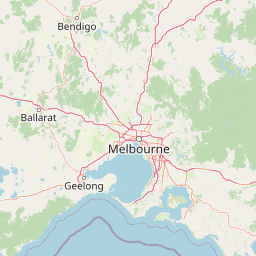
Geography guide, regional context, and park location map for Churchill National Park

Churchill National Park park geography, regions, and map view in Australia
Understand where Churchill National Park sits in Australia through a broader geographic reading of the surrounding landscape, nearby location context, and its mapped position within the national park landscape.

How Churchill National Park fits into Australia

Australia is a constitutional monarchy and federal parliamentary democracy comprising six states and ten territories. With a population of nearly 28 million, it is one of the world's most urbanised countries, with most people concentrated on the eastern seaboard. The country has a high Human Development Index and is known for its cultural diversity, ancient Aboriginal heritage, and unique wildlife.

Wider geography shaping Churchill National Park in Australia

Australia occupies the entire Australian continent, the island of Tasmania, and numerous smaller islands. It is the world's flattest and driest inhabited continent, featuring vast deserts in the interior (the Outback), tropical rainforests along the eastern coast, and a coastline bordering the Indian and Pacific Oceans.

Map view of Churchill National Park

Use this park location map to pinpoint Churchill National Park in Australia, understand its exact geographic position, and read its mapped placement within the surrounding landscape more clearly.

Pigeon | © OpenStreetMap contributors
Park atlas

Discover surrounding protected landscapes in Victoria, Australia, and compare their unique geographical features.

Explore Nearby National Parks and Protected Areas Beyond Churchill National Park
Browse a curated selection of national parks and protected areas within the Greater Melbourne region and broader Victoria, identifying diverse landscapes near Churchill National Park's woodland and historical features. This extended view allows for comparative geographic discovery, tracing regional park distribution and varied protected-area characteristics across the Australian state.
National park

Dandenong Ranges National Park: A Protected National Park Landscape

Explore its mapped terrain and regional geographic context.

Dandenong Ranges National Park represents a significant protected area near Melbourne, Australia, characterized by its steep, undulating ridges and deep gullies supporting tall, wet forests. As a national park, it safeguards a vital natural landscape, providing context for regional geography and offering insights into its terrain. This entry facilitates detailed exploration of the park's protected boundaries and its place within the Australian protected-area atlas.

Area
35.4 km²
Established
1987
IUCN
II
Visitors
1M annual
National park

French Island National Park: Protected Island National Park with Coastal Wetland Habitats

Explore mapped boundaries and diverse terrain of this unique park.

French Island National Park preserves a vital island ecosystem in Victoria, Australia, featuring extensive mangrove forests, salt marshes, and open woodland. As one of Australia's most accessible island national parks, it offers a distinctive wilderness experience primarily reached by boat, showcasing coastal conservation and unique wetland habitats. The park's geography is defined by its low-lying terrain and tidal influences, creating a rich environment for mapped landscape exploration.

Area
111 km²
Established
1998
IUCN
II
Relief
Lowland
National park

Organ Pipes National Park: Victoria National Park Featuring Columnar Basalt and Volcanic Geology

Explore unique mapped terrain and ancient protected landscapes near Melbourne.

Organ Pipes National Park stands as a crucial protected area in Victoria, Australia, celebrated for its exceptional columnar basalt formations and deep geological heritage. This national park preserves a striking landscape where ancient Silurian marine sediments meet relatively recent Pleistocene volcanic basalt, offering a profound glimpse into regional geography and land formation. Discover the park's mapped boundaries, the dramatic geological features along Jacksons Creek, and the ecological restoration efforts that highlight its value as a natural monument.

Area
1.21 km²
Established
1972
IUCN
III
Visitors
50K annual
National park

Kinglake National Park: Protected Mountain Ash Forests and Geological Heritage

Explore the mapped landscape and regional geography of this Australian National Park.

Kinglake National Park is a significant protected natural area in Victoria, Australia, distinguished by its mountainous terrain dominated by eucalyptus forests, including towering mountain ash trees. The park's unique geology features sedimentary layers with marine fossils, offering a glimpse into its ancient submerged history. This National Park provides a rich environment for exploring diverse landscapes, understanding fire ecology, and appreciating the mapped boundaries of a resilient natural area.

Area
232.1 km²
Established
1928
IUCN
II
Relief
Upland
National park

Mornington Peninsula National Park: Victoria's Coastal Protected Landscape and Map Atlas

Explore dramatic cliff-top terrain, sandy beaches, and native bushland.

Mornington Peninsula National Park is a protected natural area defined by its spectacular coastal geography in Victoria, Australia. The park features striking cliff-top vistas, extensive sandy beaches, and sculpted dunes that showcase the dynamic forces shaping Australia's coastline. Its mapped boundaries protect a vital landscape including areas like Greens Bush, offering a glimpse into the region's native vegetation and geological formations for those interested in detailed geographic context and protected area exploration.

Area
26.86 km²
Established
1995
IUCN
II
Relief
Mixed relief
National park

Yarra Ranges National Park: Victoria's Towering Mountain Ash Forests and Protected Landscape Geography

Explore mapped boundaries and vital water catchment landscapes.

Yarra Ranges National Park in Victoria, Australia, represents a significant protected landscape within the Great Dividing Range. It is renowned for its exceptionally tall mountain ash forests, which are vital carbon stores and habitats, and its critical function as a water catchment area for Melbourne. This park offers a deep dive into a unique geographic setting defined by diverse mountain terrain, temperate rainforests, and subalpine environments, all preserved for their ecological and water security importance.

Area
760 km²
Established
1995
IUCN
II
Visitors
800K annual
National park

Baw Baw National Park: Subalpine Granite Landscapes and Protected Area Geography

Discover Victoria's southernmost alpine wilderness.

Baw Baw National Park offers a rare glimpse into Australia's subalpine environment, characterized by striking granite boulder formations and iconic snow gum forests. As a protected national park, it safeguards unique ecosystems and habitats, including those for critically endangered species. This atlas entry details the park's distinctive landscape, its mapped boundaries, and its geographic significance as the southern edge of mainland alpine terrain.

Area
135.3 km²
Established
1979
IUCN
II
Relief
Mountain
National park

Bunurong Marine National Park: Protected Marine Area with Diverse Reefs and Coastal Landscapes

Explore unique rock formations and rich marine biodiversity off Victoria's coast.

Bunurong Marine National Park in Victoria, Australia, is a designated national park safeguarding remarkable marine ecosystems. Its protected geography features striking coastal features like Eagles Nest and a wealth of subtidal and intertidal rocky reefs teeming with life. This area is renowned for its high marine invertebrate diversity, significant fossil sites such as the Cape Paterson Claw discovery, and provides exceptional opportunities for mapped landscape exploration of its underwater terrains.

Area
21 km²
Established
2002
IUCN
II
Visitors
250K annual

Common questions about visiting, size, designation, and location context for Churchill National Park

Churchill National Park FAQs for park facts, access, geography, and protected area context
Find quick answers about Churchill National Park, including protected-area facts, park geography, trail and visitor context, and how the park fits into its surrounding country and regional landscape.
MoriAtlas Explorer

Continue Your Protected Areas Search Across the Global Atlas

Deepen your exploration by continuing the structured search for national parks and protected areas worldwide. Utilize the comprehensive filtering capabilities to compare different conservation landscapes and refine your understanding of global park geography. Discover more about the distribution and characteristics of protected natural areas.

Global natural geography