

Mori Atlas logo
National parkDandenong Ranges National Park

Discover the mapped boundaries and terrain of this key Australian national park.

Dandenong Ranges National Park: Protected Landscape and Regional Geography

Dandenong Ranges National Park, situated in Victoria's Greater Melbourne region, is a significant protected area defined by its tall wet forests and rolling hills. This national park preserves a vital remnant of the region's natural heritage, offering insights into its geological origins and diverse terrain. Users can explore the park's mapped boundaries, understand its role within the broader Australian landscape, and appreciate the geographic context of its unique ecosystems.

National ParkWet ForestMountain Ash ForestLyrebird HabitatWalking TrailsKokoda Memorial

Dandenong Ranges National Park

National park

Park overview

Structured park overview, official facts, and landscape profile for Dandenong Ranges National Park

Dandenong Ranges National Park park facts, protected area profile, and essential visitor context
Review the core facts for Dandenong Ranges National Park, including designation, size, terrain, visitor scale, habitats, and operating context in one park-focused overview.

About Dandenong Ranges National Park

Dandenong Ranges National Park protects a chain of heavily timbered ridges and valleys that form a green backdrop to Melbourne's eastern suburbs. The park's establishment in 1987 consolidated several earlier protected areas, including the historic Ferntree Gully reserve which was first protected in 1882, Sherbrooke Forest famous for its lyrebirds, and the Doongalla Estate. Additional lands including Olinda State Forest, Mount Evelyn Forest, and Montrose Reserve were incorporated in 1997, expanding the park to its current extent. The Dandenong Ranges represent the remains of an ancient volcano that dominated the landscape millions of years ago, and the park's terrain reflects this geological heritage with steep ridges, sheltered gullies, and several prominent peaks including Mount Dandenong. The forests here are dominated by tall mountain ash eucalyptus trees that create a cathedral-like canopy, interspersed with dense understory of ferns, shrubs, and moss-covered logs. The park lies within the traditional Country of the Bunurong and Woewurrung Aboriginal people, whose connection to these lands predates European settlement by thousands of years. Today the park provides essential ecosystem services for the Melbourne region, including water catchment protection, air quality maintenance, and climate moderation, while offering residents and visitors a readily accessible wilderness experience within easy driving distance of the city.

Quick facts and research context for Dandenong Ranges National Park

Dandenong Ranges National Park covers 3,540 hectares (8,700 acres) in Victoria, Australia, established on 13 December 1987. The park is managed by Parks Victoria and is located 31 to 45 kilometers east of Melbourne's central business district, spanning the communities of Ferntree Gully, Boronia, Belgrave, Mount Dandenong, Upwey, and Silvan. The park encompasses five main sections: Doongalla Forest, Ferntree Gully, Mount Evelyn Forest, Olinda Forest, and Sherbrooke Forest, with Montrose Reserve added in 1997. The park features the famous Thousand Steps (Kokoda Track Memorial Walk), Sherbrooke Forest known for lyrebirds, and the SkyHigh lookout on Mount Dandenong.

Park context

Deeper park guide and search-rich context for Dandenong Ranges National Park

Dandenong Ranges National Park history, landscape, wildlife, and travel context
Explore Dandenong Ranges National Park through its history, landscape character, ecosystems, wildlife, conservation priorities, cultural context, and seasonal travel timing in a structured park guide built for atlas discovery and search intent.

Why Dandenong Ranges National Park stands out

Dandenong Ranges National Park is best known for its dense wet forests of mountain ash and manna gum that shelter populations of superb lyrebirds, whose spectacular mimetic songs echo through the gullies. The park's most iconic feature is the Thousand Steps trail, a steep 2.5-kilometer walking track with over 700 steps ascending to One Tree Hill, which serves as both a fitness destination and a memorial to the Kokoda Track campaign of World War II. Sherbrooke Forest within the park is renowned as one of the best places in Victoria to observe lyrebirds in their natural habitat, while the SkyHigh lookout on Mount Dandenong provides panoramic views over Melbourne's eastern suburbs. The park's proximity to a major metropolitan area, combined with its network of walking tracks, picnic areas, andlookouts, makes it one of Victoria's most visited national parks.

Dandenong Ranges National Park history and protected-area timeline

The lands now protected within Dandenong Ranges National Park have a long history of human presence and modification. The Dandenong Ranges were originally inhabited by the Bunurong and Woewurrung Aboriginal peoples, who utilized the forest resources and lived in harmony with the landscape for thousands of years before European contact. European settlement beginning in the mid-1800s brought significant change as the dense forests were cleared to provide timber for Melbourne's growing construction needs. Roads and railways were constructed through the ranges, including the famous Puffing Billy narrow-gauge railway line from Ferntree Gully to Gembrook which began operation in 1900. Small-scale farming developed in the clearer areas as infrastructure improved. Tourism to the area flourished from the 1870s onward, with visitors drawn to the cool forest environments and scenic viewpoints. Ferntree Gully was reserved as a park in 1882, making it one of Victoria's earliest protected areas, and additional reserves were created over subsequent decades. The present national park was proclaimed on 13 December 1987, amalgamating Ferntree Gully National Park, Sherbrooke Forest, and Doongalla Estate into a single protected area. In 1997, the Olinda State Forest, Mount Evelyn Forest, and Montrose Reserve were formally added to the park, completing its current configuration.

Dandenong Ranges National Park landscape and geographic character

The Dandenong Ranges National Park encompasses a landscape of moderate elevation but pronounced relief, characterized by steeply undulating ridges, deep gullies, and several prominent peaks including Mount Dandenong which rises above the surrounding terrain. The park sits within a chain of ancient volcanic origin, with the underlying geology providing the fertile soils that support the park's tall forest growth. Elevation within the park ranges from approximately 100 meters in the lower foothills to over 700 meters at the higher points, creating diverse microclimates across its extent. The park's deeply incised valleys capture moisture and provide sheltered environments where moisture-loving ferns, mosses, and epiphytic plants thrive. The landscape is punctuated by numerous viewpoints, with the SkyHigh lookout on Mount Dandenong offering perhaps the most spectacular panoramic vista, sweeping across Melbourne's eastern suburbs to the distant You Yangs and Port Phillip Bay. The forest structure varies across the park, with wetter areas supporting tall mountain ash forests with dense understories, while drier ridges feature messmate and manna gum woodland. Numerous small creeks and drainage lines traverse the terrain, feeding into larger stream systems that eventually flow toward Port Phillip Bay.

Dandenong Ranges National Park ecosystems, habitats, and plant life

The forests of Dandenong Ranges National Park represent some of the most intact wet forest ecosystems remaining in the Melbourne region. The dominant tree species is mountain ash, one of the world's tallest flowering plants, which can reach heights exceeding 80 meters in ideal conditions and creates a towering canopy that filters light into the forest interior. These tall eucalypt forests are interspersed with areas of cool temperate rainforest in the wettest gullies, where species such as myrtle beech and soft tree fern create a distinctly different environment from the surrounding eucalypt-dominated slopes. The forest understory is characteristically dense, comprising a diverse layer of shrubs, ferns, and groundcover plants including grass trees, helmet orchids, and various native iris species. The park supports a range of ecological communities listed as significant under Victorian legislation, recognizing their rarity and the threats they face from the surrounding urban environment. Water quality in the park's streams is monitored and maintained as these waterways provide crucial habitat for aquatic species and also serve as important catchment sources for downstream water supply.

Dandenong Ranges National Park wildlife and species highlights

Dandenong Ranges National Park is perhaps most famous for its populations of superb lyrebirds, ground-dwelling birds renowned for their extraordinary ability to mimic the calls of other birds as well as mechanical and human sounds. Sherbrooke Forest within the park has long been recognized as an outstanding location for observing these remarkable birds, and visitor numbers of lyrebirds have increased dramatically since the introduction of a cat curfew across the Dandenong Ranges area in 1991. The park also supports a diverse community of marsupials including common ringtail and brushtail possums, echidnas, and various microbats that roost in the hollow-bearing trees. Birdlife is particularly diverse, with over 180 species recorded in the park including wedge-tailed eagles, laughing jackass (kingfisher), crimson rosellas, and a variety of honeyeaters and thornbills. The dense ground cover provides habitat for reptiles including skinks and dragons, while the older trees with their hollows provide nesting sites for powerful owls and cockatoos. The urban interface presents ongoing challenges from introduced predators, and the park management works actively to control populations of feral cats and foxes that predate on native wildlife.

Dandenong Ranges National Park conservation status and protection priorities

Dandenong Ranges National Park plays a critical conservation role in a landscape largely transformed by urban and agricultural development. The park protects significant remnants of the wet forest ecosystems that once covered much of the Dandenong Ranges, now isolated within a matrix of suburbs and farmland. These forest remnants serve as wildlife corridors connecting larger protected areas to the east, allowing for animal movement through an otherwise fragmented landscape. The park's conservation values have been recognized through its inclusion in Victoria's system of national parks and its designation as an IUCN Category II protected area. Management focuses on controlling invasive species, maintaining forest health, and protecting water quality in the park's streams. The dramatic recovery of lyrebird populations following the 1991 cat curfew demonstrates the effectiveness of landscape-scale predator control and illustrates how even small pockets of protected habitat can support significant biodiversity when given adequate protection from introduced predators.

Dandenong Ranges National Park cultural meaning and human context

The Dandenong Ranges hold deep significance for the Bunurong and Woewurrung peoples, whose traditional Country encompasses these forested ridges and valleys. The landscape features in Aboriginal culture and tradition, though detailed records of specific cultural sites within the park are managed sensitively by traditional owners. European settlement brought dramatic changes to the landscape, with large-scale timber extraction clearing much of the original forest cover. The establishment of the Puffing Billy railway in 1900 facilitated both settlement and tourism, and the steep terrain that challenged early settlers and railway engineers now forms the backdrop for popular walking trails including the Thousand Steps. The Thousand Steps track itself carries cultural significance as a memorial to Australian soldiers who fought in the Kokoda Track campaign during World War II, linking the physical landscape to a broader narrative of Australian military history and commemoration. The forest environments also inspired artistic and literary output throughout the twentieth century, with the Dandenong Ranges becoming associated with notions of Melbourne's environmental consciousness and connection to nature.

Top sights and standout views in Dandenong Ranges National Park

Dandenong Ranges National Park offers visitors a wealth of experiences within easy reach of central Melbourne. The Thousand Steps (Kokoda Track Memorial Walk) stands as the park's most iconic trail, ascending steeply through forest to the One Tree Hill summit with its sweeping views, while commemorating Australian service in the Papua New Guinea campaign. Sherbrooke Forest provides the best opportunity to observe superb lyrebirds, with early morning walks often rewarded by sightings of these remarkable mimetic birds. The SkyHigh lookout on Mount Dandenong delivers panoramic views across greater Melbourne, making it a popular destination for both tourists and locals seeking orienting perspectives on the city. The network of walking tracks throughout the park suits visitors of varying fitness levels, from gentle forest strolls to more challenging ridge-top hikes. The park's proximity to Melbourne ensures accessibility for day visitors while its size and diversity provide meaningful wilderness experiences away from the urban edge.

Best time to visit Dandenong Ranges National Park

The Dandenong Ranges National Park can be enjoyed year-round, though each season offers distinct advantages. Autumn and winter bring cooler temperatures and reduced visitor numbers, creating ideal conditions for forest walking and lyrebird observation as birds become more active and visible during the cooler months. The forest canopy in winter allows more light to penetrate to the forest floor, making tracks easier to navigate and wildlife easier to spot. Spring brings wildflower displays and the sounds of breeding bird activity, though this is also the busiest season for visitors. Summer offers warm conditions suitable for the forest shaded tracks but can see higher visitor numbers on weekends. The mountain ash forests are spectacular at any time of year, with the tall straight trunks and filtered light creating a distinctive atmosphere regardless of season. Early morning visits generally offer the best wildlife viewing opportunities and the chance to experience the forest before it becomes busy.
Park location guide

Geography guide, regional context, and park location map for Dandenong Ranges National Park

Dandenong Ranges National Park park geography, regions, and map view in Australia
Understand where Dandenong Ranges National Park sits in Australia through a broader geographic reading of the surrounding landscape, nearby location context, and its mapped position within the national park landscape.

How Dandenong Ranges National Park fits into Australia

Australia is a constitutional monarchy and federal parliamentary democracy comprising six states and ten territories. With a population of nearly 28 million, it is one of the world's most urbanised countries, with most people concentrated on the eastern seaboard. The country has a high Human Development Index and is known for its cultural diversity, ancient Aboriginal heritage, and unique wildlife.

Wider geography shaping Dandenong Ranges National Park in Australia

Australia occupies the entire Australian continent, the island of Tasmania, and numerous smaller islands. It is the world's flattest and driest inhabited continent, featuring vast deserts in the interior (the Outback), tropical rainforests along the eastern coast, and a coastline bordering the Indian and Pacific Oceans.

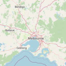
Map view of Dandenong Ranges National Park

Use this park location map to pinpoint Dandenong Ranges National Park in Australia, understand its exact geographic position, and read its mapped placement within the surrounding landscape more clearly.

Pigeon | © OpenStreetMap contributors
Park atlas

Trace the mapped geography of surrounding protected areas and compare unique conservation landscapes across the Greater Melbourne region.

Explore Other National Parks Near Dandenong Ranges National Park: Compare Protected Areas in Victoria, Australia
Explore national parks and protected areas surrounding Dandenong Ranges National Park, revealing comparable wet forests, mountain ash habitats, and diverse terrain throughout Victoria, Australia. Continue atlas-style discovery by comparing nearby conservation landscapes, tracing regional park distribution, and mapping distinct ecological features within the Greater Melbourne protected area network.
National park

Churchill National Park: Remnant Woodland and Industrial Heritage in Victoria, Australia

Mapped protected area with notable bird diversity and historical quarry sites.

Churchill National Park offers a unique glimpse into Victoria's remnant woodland ecosystems and early twentieth-century industrial history. As a national park, it protects critical habitats for a variety of bird species and preserves the landscape features of historical quarrying operations, including the Scoresby Tramway ruins. The park's mapped geography and accessible walking tracks, like the Channel Track, provide opportunities for exploration and understanding its role as a protected natural and historical asset near Melbourne.

Area
2.71 km²
Established
1941
IUCN
II
Relief
Upland
National park

Kinglake National Park: Protected Mountain Ash Forests and Geological Heritage

Explore the mapped landscape and regional geography of this Australian National Park.

Kinglake National Park is a significant protected natural area in Victoria, Australia, distinguished by its mountainous terrain dominated by eucalyptus forests, including towering mountain ash trees. The park's unique geology features sedimentary layers with marine fossils, offering a glimpse into its ancient submerged history. This National Park provides a rich environment for exploring diverse landscapes, understanding fire ecology, and appreciating the mapped boundaries of a resilient natural area.

Area
232.1 km²
Established
1928
IUCN
II
Relief
Upland
National park

Yarra Ranges National Park: Victoria's Towering Mountain Ash Forests and Protected Landscape Geography

Explore mapped boundaries and vital water catchment landscapes.

Yarra Ranges National Park in Victoria, Australia, represents a significant protected landscape within the Great Dividing Range. It is renowned for its exceptionally tall mountain ash forests, which are vital carbon stores and habitats, and its critical function as a water catchment area for Melbourne. This park offers a deep dive into a unique geographic setting defined by diverse mountain terrain, temperate rainforests, and subalpine environments, all preserved for their ecological and water security importance.

Area
760 km²
Established
1995
IUCN
II
Visitors
800K annual
National park

Organ Pipes National Park: Victoria National Park Featuring Columnar Basalt and Volcanic Geology

Explore unique mapped terrain and ancient protected landscapes near Melbourne.

Organ Pipes National Park stands as a crucial protected area in Victoria, Australia, celebrated for its exceptional columnar basalt formations and deep geological heritage. This national park preserves a striking landscape where ancient Silurian marine sediments meet relatively recent Pleistocene volcanic basalt, offering a profound glimpse into regional geography and land formation. Discover the park's mapped boundaries, the dramatic geological features along Jacksons Creek, and the ecological restoration efforts that highlight its value as a natural monument.

Area
1.21 km²
Established
1972
IUCN
III
Visitors
50K annual
National park

French Island National Park: Protected Island National Park with Coastal Wetland Habitats

Explore mapped boundaries and diverse terrain of this unique park.

French Island National Park preserves a vital island ecosystem in Victoria, Australia, featuring extensive mangrove forests, salt marshes, and open woodland. As one of Australia's most accessible island national parks, it offers a distinctive wilderness experience primarily reached by boat, showcasing coastal conservation and unique wetland habitats. The park's geography is defined by its low-lying terrain and tidal influences, creating a rich environment for mapped landscape exploration.

Area
111 km²
Established
1998
IUCN
II
Relief
Lowland
National park

Baw Baw National Park: Subalpine Granite Landscapes and Protected Area Geography

Discover Victoria's southernmost alpine wilderness.

Baw Baw National Park offers a rare glimpse into Australia's subalpine environment, characterized by striking granite boulder formations and iconic snow gum forests. As a protected national park, it safeguards unique ecosystems and habitats, including those for critically endangered species. This atlas entry details the park's distinctive landscape, its mapped boundaries, and its geographic significance as the southern edge of mainland alpine terrain.

Area
135.3 km²
Established
1979
IUCN
II
Relief
Mountain
Watercolor illustration showing a lake surrounded by green hills and vegetation
National park

Lake Eildon National Park: Protected Landscape with Ancient Volcanic and Gold Mining Heritage

Explore mapped terrain and diverse eucalypt forests.

Lake Eildon National Park in Victoria's Central Highlands offers a unique protected landscape shaped by ancient volcanic activity and the region's gold rush era. This national park, centered around the large Lake Eildon reservoir, provides critical habitat within its diverse eucalypt forests. Discover its geological significance, historical mining sites, and mapped boundaries, offering a comprehensive view of its protected-area identity and regional geographic context.

Area
277.5 km²
Established
1997
IUCN
II
Relief
Mountain
National park

Mornington Peninsula National Park: Victoria's Coastal Protected Landscape and Map Atlas

Explore dramatic cliff-top terrain, sandy beaches, and native bushland.

Mornington Peninsula National Park is a protected natural area defined by its spectacular coastal geography in Victoria, Australia. The park features striking cliff-top vistas, extensive sandy beaches, and sculpted dunes that showcase the dynamic forces shaping Australia's coastline. Its mapped boundaries protect a vital landscape including areas like Greens Bush, offering a glimpse into the region's native vegetation and geological formations for those interested in detailed geographic context and protected area exploration.

Area
26.86 km²
Established
1995
IUCN
II
Relief
Mixed relief

Common questions about visiting, size, designation, and location context for Dandenong Ranges National Park

Dandenong Ranges National Park FAQs for park facts, access, geography, and protected area context
Find quick answers about Dandenong Ranges National Park, including protected-area facts, park geography, trail and visitor context, and how the park fits into its surrounding country and regional landscape.
MoriAtlas Explorer

Continue Your Protected Areas Search Across the Global Atlas

Deepen your exploration by continuing the structured search for national parks and protected areas worldwide. Utilize the comprehensive filtering capabilities to compare different conservation landscapes and refine your understanding of global park geography. Discover more about the distribution and characteristics of protected natural areas.

Global natural geography