

Mori Atlas logo
National parkConception Island National Park

Discover the mapped boundaries and regional context of this Bahamian national park.

Conception Island National Park: Protected Landscape and Geographic Atlas in the Bahamas

Conception Island National Park stands as a significant protected area within the Bahamas, offering a unique point of discovery for those interested in island geography and conservation landscapes. This national park, situated within the Atlantic Islands, provides a distinct geographic identity. Explore its mapped boundaries and understand its place within the archipelago's broader natural terrain through detailed atlas information.

Mangrove ecosystemsSea turtle nesting siteCaribbean islandsBahamas protected areasCoastal wetlandsMarine conservation

Conception Island National Park

National park

Park overview

Structured park overview, official facts, and landscape profile for Conception Island National Park

Conception Island National Park park facts, protected area profile, and essential visitor context
Review the core facts for Conception Island National Park, including designation, size, terrain, visitor scale, habitats, and operating context in one park-focused overview.

About Conception Island National Park

Conception Island National Park occupies a small but ecologically significant island in the central Bahamas archipelago. The island's geography is characteristic of the Bahamian out islands, featuring low-lying terrain, coastal mangrove communities, and strand vegetation along its shores. The park's establishment in 1964 made it one of the earlier protected areas in the Bahamas, reflecting an early recognition of the ecological importance of the island's habitats. The Bahamas National Trust has administered the park since its creation, maintaining the protected status that preserves both the terrestrial and surrounding marine environments. The island's location between the larger islands of Cat Island and Rum Cay places it within a broader network of Bahamian protected areas that together form an important conservation corridor across the central Bahamas. The park's relatively flat topography, with maximum elevations of just 20 meters, reflects the geological character of the island as a low-lying carbonate platform typical of the region.

Quick facts and research context for Conception Island National Park

Conception Island National Park covers approximately 30,000 acres including marine and terrestrial areas, with a land area of 810 hectares. The park was established in 1964 and is managed by the Bahamas National Trust, the nation's primary conservation authority. The island features mangrove-dominated habitats along its coast and typical strand vegetation inland. It is recognized as one of the most important nesting sites for green sea turtles in the entire Bahamas, a distinction that gives the park significant conservation value within the Caribbean region.

Park context

Deeper park guide and search-rich context for Conception Island National Park

Conception Island National Park history, landscape, wildlife, and travel context
Explore Conception Island National Park through its history, landscape character, ecosystems, wildlife, conservation priorities, cultural context, and seasonal travel timing in a structured park guide built for atlas discovery and search intent.

Why Conception Island National Park stands out

Conception Island National Park is best known for its extensive mangrove ecosystems and its role as a premier nesting site for green sea turtles in the Bahamas. The island's protected status has helped preserve one of the region's most important coastal wetland complexes, where mangrove communities dominate the shoreline and provide critical habitat for marine life. The park also serves as a significant stopover and nesting area for numerous seabird species and migratory birds, making it an important location for avian conservation in the Caribbean.

Conception Island National Park history and protected-area timeline

Conception Island National Park was established in 1964, making it one of the earliest national parks in the Bahamas. The creation of the park reflected a growing awareness in the mid-20th century of the need to protect the Bahamas' unique coastal and island ecosystems. The Bahamas National Trust, founded to manage the nation's protected areas, assumed administrative responsibility for the park. Beyond its ecological significance, the island has historical cultural interest due to a theory proposed by Washington Irving that identified Conception Island as one of Christopher Columbus' landfall sites during his 1492 voyage. However, this early attribution was not supported by subsequent historians, who identified other islands in the Bahamas as more likely candidates for Columbus' first landfall. This historical note, while unverified, adds a layer of cultural context to the island's identity.

Conception Island National Park landscape and geographic character

The landscape of Conception Island National Park is defined by its low-lying coastal geography and extensive mangrove systems. The island's terrain is nearly flat, reaching only 20 meters at its highest point, which is characteristic of the limestone-based islands that make up the Bahamian archipelago. Along the island's margins, dense mangrove communities dominate, creating a distinctive coastal ecosystem where tidal waters flow through root systems that support diverse marine life. The interior of the island features typical strand vegetation adapted to the salty, windswept environment of a small Caribbean island. The surrounding waters, while not technically part of the land-based park designation, are integral to the island's ecological function, with mangrove ecosystems extending into the shallow marine environment. The overall visual character is one of low green vegetation rising only slightly above sea level, surrounded by the turquoise waters of the Bahamas.

Conception Island National Park ecosystems, habitats, and plant life

The nature of Conception Island National Park centers on its mangrove-dominated coastal ecosystem, which represents one of the most ecologically important habitat types in the Caribbean region. Mangroves serve as critical nurseries for fish and crustaceans, stabilize coastlines, and filter water, making them among the most productive ecosystems in tropical marine environments. The strand vegetation inland includes species adapted to coastal conditions, including salt tolerance and wind resistance. The island's position within the Bahamas places it within a broader network of marine ecosystems that support significant biodiversity. The relatively undisturbed nature of the island, protected since 1964, has allowed these ecosystems to persist with less human disturbance than many other Caribbean coastlines have experienced.

Conception Island National Park wildlife and species highlights

The wildlife of Conception Island National Park is most notable for the island's significance as a nesting site for green sea turtles, which rank among the most important marine reptiles in the Caribbean. Green sea turtles return to the island's beaches to lay their eggs, making Conception Island one of the most important nesting sites in the Bahamas for this species. The surrounding waters provide foraging habitat for juvenile and adult turtles. Beyond marine reptiles, the island supports substantial seabird populations and serves as a critical stopover for migratory birds traveling through the Caribbean. The mangrove habitats support fish, crustaceans, and other marine species that rely on these productive coastal ecosystems. The combination of marine, coastal, and terrestrial habitats creates a relatively complete ecological system within the small island boundary.

Conception Island National Park conservation status and protection priorities

Conception Island National Park holds significant conservation importance within the Bahamas and the broader Caribbean region. The protection of the island's mangrove ecosystems preserves habitat that is critical for marine species at multiple life stages, from spawning grounds to juvenile nurseries. The park's status as a major green sea turtle nesting site gives it particular conservation significance, as sea turtle populations throughout the Caribbean face pressures from habitat loss, egg predation, and human interaction. The long-established protected status, dating to 1964, has provided decades of continuous protection that has allowed these ecological values to persist. The Bahamas National Trust's management of the park ensures that conservation priorities remain central to the site's stewardship, maintaining the protected area's ecological integrity.

Conception Island National Park cultural meaning and human context

While the ecological values of Conception Island are the primary basis for its protected status, the island also carries a degree of historical cultural interest related to early exploration of the Americas. The writer Washington Irving proposed that Conception Island was one of the sites where Christopher Columbus landed during his 1492 voyage, a theory that would have given the island a place in the foundational narrative of European contact with the Americas. However, this attribution was not accepted by subsequent historical scholarship, which has identified other islands in the Bahamas as more plausible candidates for Columbus' first landfall. This historical note, while unverified, adds a layer of cultural context to the island without altering the primary conservation rationale for its protected status.

Top sights and standout views in Conception Island National Park

Conception Island National Park stands out as one of the Bahamas' most important protected areas for coastal and marine conservation. The park's extensive mangrove habitats represent critical ecosystems that support marine food webs and provide nursery habitat for commercially and ecologically important species. The island's status as a major green sea turtle nesting site distinguishes it within the Bahamas, as few other islands provide such important nesting grounds for this endangered marine reptile. The park's age, established in 1964, makes it one of the more mature protected areas in the Bahamas, with decades of continuous conservation stewardship. The combination of terrestrial, coastal, and marine habitats within a single protected designation creates a relatively comprehensive conservation unit that preserves ecological processes across multiple environments.

Best time to visit Conception Island National Park

The best time to visit Conception Island National Park aligns with the broader patterns of Bahamian weather and the ecological cycles of the island's key species. The dry season from late autumn through spring offers generally more stable weather conditions for island visits. Green sea turtle nesting occurs during warmer months, and visitors traveling during peak summer may witness nesting activity if conditions permit. Migratory bird passage through the Bahamas occurs during spring and autumn, providing opportunities to observe transient species using the island as a stopover. The flat, low-lying nature of the island means that visitors should be aware of hurricane season risks during the summer and autumn months, when tropical weather can affect travel plans.
Park location guide

Geography guide, regional context, and park location map for Conception Island National Park

Conception Island National Park park geography, regions, and map view in Bahamas
Understand where Conception Island National Park sits in Bahamas through a broader geographic reading of the surrounding landscape, nearby location context, and its mapped position within the national park landscape.

How Conception Island National Park fits into Bahamas

The Bahamas is an island nation in the Atlantic Ocean, forming part of the Lucayan Archipelago. It consists of more than 3,000 islands, cays and islets located north of Cuba, northwest of Hispaniola, and southeast of Florida. The country gained independence from Britain in 1973 and operates as a constitutional monarchy under King Charles III, with Nassau as its capital and largest city.

Wider geography shaping Conception Island National Park in Bahamas

The Bahamas occupies the Lucayan Archipelago in the Atlantic Ocean. The island chain is positioned north of Cuba, northwest of Hispaniola (shared by the Dominican Republic and Haiti), southeast of the US state of Florida, and east of the Florida Keys. The territory spans over 3,000 islands, cays and islets, with the total land area being 13,943 km². The Royal Bahamas Defence Force claims approximately 470,000 km² of surrounding ocean space.

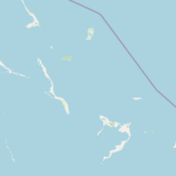
Map view of Conception Island National Park

Use this park location map to pinpoint Conception Island National Park in Bahamas, understand its exact geographic position, and read its mapped placement within the surrounding landscape more clearly.

Pigeon | © OpenStreetMap contributors

Location context for Conception Island National Park

Conception Island
Park atlas

Compare Coastal Ecosystems and Island Protected Areas Across the Bahamas and Wider Caribbean

Explore Protected Areas and National Parks Surrounding Conception Island National Park
From Conception Island National Park, continue mapping the unique protected areas across the Bahamas and broader Caribbean region. Compare their coastal wetlands, marine conservation efforts, and island ecosystems to understand regional conservation landscapes.
National parkExuma

Moriah Harbour Cay National Park: Protected Area Atlas and Geographic Context within Exuma

Explore mapped boundaries and landscape identity.

Gain a comprehensive understanding of Moriah Harbour Cay National Park as a protected landscape within the Exuma region. This entry provides essential geographic context, detailing its mapped territory and unique natural characteristics for atlas-based discovery. Understand the park's significance through its protected area designation and its place within the broader Bahamian geography.

Area
68 km²
Established
2002
Relief
Lowland
Scope
Mixed
National parkBahamas

Exuma Cays Land and Sea Park National Park: Mapped Protected Landscape in the Bahamas

Explore its geographic identity and atlas context.

This page provides detailed map-based information on Exuma Cays Land and Sea Park, a significant national park located in the Bahamas. Discover its protected area boundaries, explore its unique geographic setting within the archipelago, and understand its role as a key natural landscape. The content is geared towards atlas exploration, offering a factual overview of the park's spatial and regional importance without any visitor logistics or operational details.

Area
455.84 km²
Established
1959
Relief
Lowland
Climate
Tropical
National parkBahamas

Bonefish Pond National Park: Essential Bahamas Coastal Wetland & Marine Nursery

Mapped protected area, mangrove ecosystem, and habitat for key marine species.

Bonefish Pond National Park, a protected national park on New Providence island in The Bahamas, is essential for its role as a thriving marine nursery. The park's landscape features extensive red mangrove forests, tidal channels, and shallow lagoons crucial for juvenile bonefish, crawfish, and conch. This area highlights effective wetland restoration and conservation, offering valuable insights into Caribbean coastal protected landscapes and their geographic importance.

Area
5 km²
Established
2002
IUCN
II
Relief
Lowland
National parkBahamas

Primeval Forest National Park: A Protected Landscape within the Bahamas Archipelago

Explore mapped boundaries and regional geography in the Lucayan Archipelago.

Primeval Forest National Park serves as a key protected area within the Bahamas, offering a focused view of island geography and conservation landscapes. This national park is a critical element for understanding the archipelago's natural terrain and mapped protected lands. Its presence provides valuable geographic context, allowing for detailed exploration of its boundaries and its place within the broader Bahamian atlas.

Established
2002
Relief
Mixed relief
Climate
Tropical
Access
Easy access
National parkBahamas

Little Inagua National Park: Remote Bahamian Protected Landscape & Marine Habitat

Island wilderness, sea turtle nesting, and queen conch larval zones.

Little Inagua National Park, located in the Bahamas, is a remote national park combining terrestrial and marine conservation efforts. This protected area is primarily recognized for its role as a critical nesting site for sea turtles and its importance for queen conch larval development in the surrounding Caribbean waters. Discover the distinct island terrain and shallow marine ecosystems that define this ecologically significant Bahamian protected landscape.

Area
254 km²
Established
2002
IUCN
II
Climate
Tropical
National parkAndros

Crab Replenishment Reserve National Park: Explore Andros Protected Landscape Boundaries

Mapped geography and regional park context

Investigate Crab Replenishment Reserve National Park, a significant protected landscape located in the Andros region. This page provides detailed atlas-style information, focusing on the park's mapped boundaries and its specific geographic setting. Understand how this national park contributes to the regional protected area network and its overall landscape identity for atlas-driven exploration.

Area
16 km²
Established
2002
IUCN
II
Relief
Lowland
National parkBahamas

West Side National Park National Park: Extensive Protected Landscape in the Bahamas

Mapped marine and mangrove ecosystems, plus pine forest terrain

Delve into the geographical identity of West Side National Park, a protected national park in the Bahamas renowned for its vast scale and diverse ecosystems. This landscape features significant Caribbean pine forests transitioning into extensive, intact mangrove systems along its coastlines, integrating directly with vital marine habitats. As one of the largest protected areas in the Caribbean, its ecological representation from land to sea offers a unique atlas perspective on Bahamian natural heritage and conservation.

Area
6,070 km²
Established
2002
IUCN
II
Relief
Mixed relief
Watercolor painting of a coastline with green hills, a single tree, calm sea, and light sky
National parkBahamas

Inagua National Park: Bahamian National Park Geography and Mapped Boundaries

Discover the protected landscape and regional atlas context.

Delve into the specifics of Inagua National Park, a protected national park situated within the Bahamas. This entry focuses on its geographic identity, mapped protected area extent, and its place within the archipelago's broader natural landscape context. Understand the park's structured details and its mapped presence for atlas exploration, providing a foundation for understanding Bahamian conservation lands.

Area
890 km²
Established
1965
Relief
Lowland
Climate
Tropical

Common questions about visiting, size, designation, and location context for Conception Island National Park

Conception Island National Park FAQs for park facts, access, geography, and protected area context
Find quick answers about Conception Island National Park, including protected-area facts, park geography, trail and visitor context, and how the park fits into its surrounding country and regional landscape.
MoriAtlas Explorer

Continue Your Protected Areas Search Across the Global Atlas

Deepen your exploration by continuing the structured search for national parks and protected areas worldwide. Utilize the comprehensive filtering capabilities to compare different conservation landscapes and refine your understanding of global park geography. Discover more about the distribution and characteristics of protected natural areas.

Global natural geography