
Mori Atlas logo
National parkInagua National Park

Discover the mapped boundaries and regional landscape identity of this national park.

Inagua National Park: Protected Landscape Atlas and Geographic Context in the Bahamas

Inagua National Park stands as a significant protected area within the Bahamas, offering a unique glimpse into the island nation's natural landscapes. This detail page provides an atlas-centric view, highlighting the park's geographic setting within the Lucayan Archipelago and detailing its mapped protected boundaries. Understand the park's role and context within the broader Bahamian geography and its mapped conservation lands.

Caribbean IslandsWetland ReservesBirdwatchingFlamingo HabitatRamsar SiteProtected Areas
Stylized illustration of rocky coastal cliffs with turquoise ocean waves crashing against the shore under a sunset sky with layered clouds.

Inagua National Park

National park

Park overview

Structured park overview, official facts, and landscape profile for Inagua National Park

Inagua National Park park facts, protected area profile, and essential visitor context

Review the core facts for Inagua National Park, including designation, size, terrain, visitor scale, habitats, and operating context in one park-focused overview.

About Inagua National Park

Inagua National Park encompasses virtually all of Great Inagua, an island of approximately 596 square miles located in the southeastern Bahamas. The park's establishment in 1965 marked a pivotal moment in Caribbean conservation history, creating the first large-scale protected area in the Bahamas archipelago. The landscape within the park boundaries is remarkably varied, featuring extensive tidal flats along the coast, the interior Lake Rosa covering substantial acreage, dense coppice scrub, and patches of pine forest in higher elevations. This geographic diversity supports a wide range of ecological communities and makes Inagua one of the most biologically significant islands in the Bahamas. The park's remote location and vast size have allowed natural processes to continue relatively undisturbed, while the protection framework has enabled species recovery programs to succeed dramatically. Inagua serves not only as a refuge for resident species but also as a critical waypoint for migratory birds traveling between North and South America, reinforcing its importance within broader Atlantic flyway systems.

Quick facts and research context for Inagua National Park

Inagua National Park is located on Great Inagua in the southeastern Bahamas, covering roughly 220,000 acres and encompassing the island's interior and coastal zones. The park was established in 1965 through the Bahamas National Trust and remains the largest protected area in the Bahamas. It contains Lake Rosa, the largest saltwater lake in the Bahamas, and protects the single largest breeding colony of West Indian flamingos anywhere in the world. The park was designated a Ramsar Wetland in February 1999 and is recognized as an Important Bird Area by birdwatching organizations globally.

Protection and recognition

Documenting official designation records and global conservation status

Inagua National Park Protection Status and International Recognition

Researchers can verify the established designation framework for Inagua National Park, which gained formal protection status in 1999. Verified data records trace the geographic boundaries and official designations of the area, including its status as a recognized Ramsar site.

International recognition

Protection details

Protection scope
Mixed
Designated year
1999
Transboundary protection
No
Park context

Deeper park guide and search-rich context for Inagua National Park

Inagua National Park history, landscape, wildlife, and travel context

Explore Inagua National Park through its history, landscape character, ecosystems, wildlife, conservation priorities, cultural context, and seasonal travel timing in a structured park guide built for atlas discovery and search intent.

Why Inagua National Park stands out

Inagua National Park is world-renowned for its spectacular flamingo population, which represents the largest breeding colony of the West Indian flamingo species on Earth. The park's shallow coastal flats and wetlands provide ideal feeding and nesting conditions for these distinctive pink birds, which number over 50,000 individuals. Beyond flamingos, the park supports exceptional bird biodiversity and is celebrated as a premier birdwatching destination in the Caribbean. The presence of Lake Rosa, a massive saltwater lake within the park boundaries, adds to the area's ecological distinction and provides habitat for additional bird species and marine life.
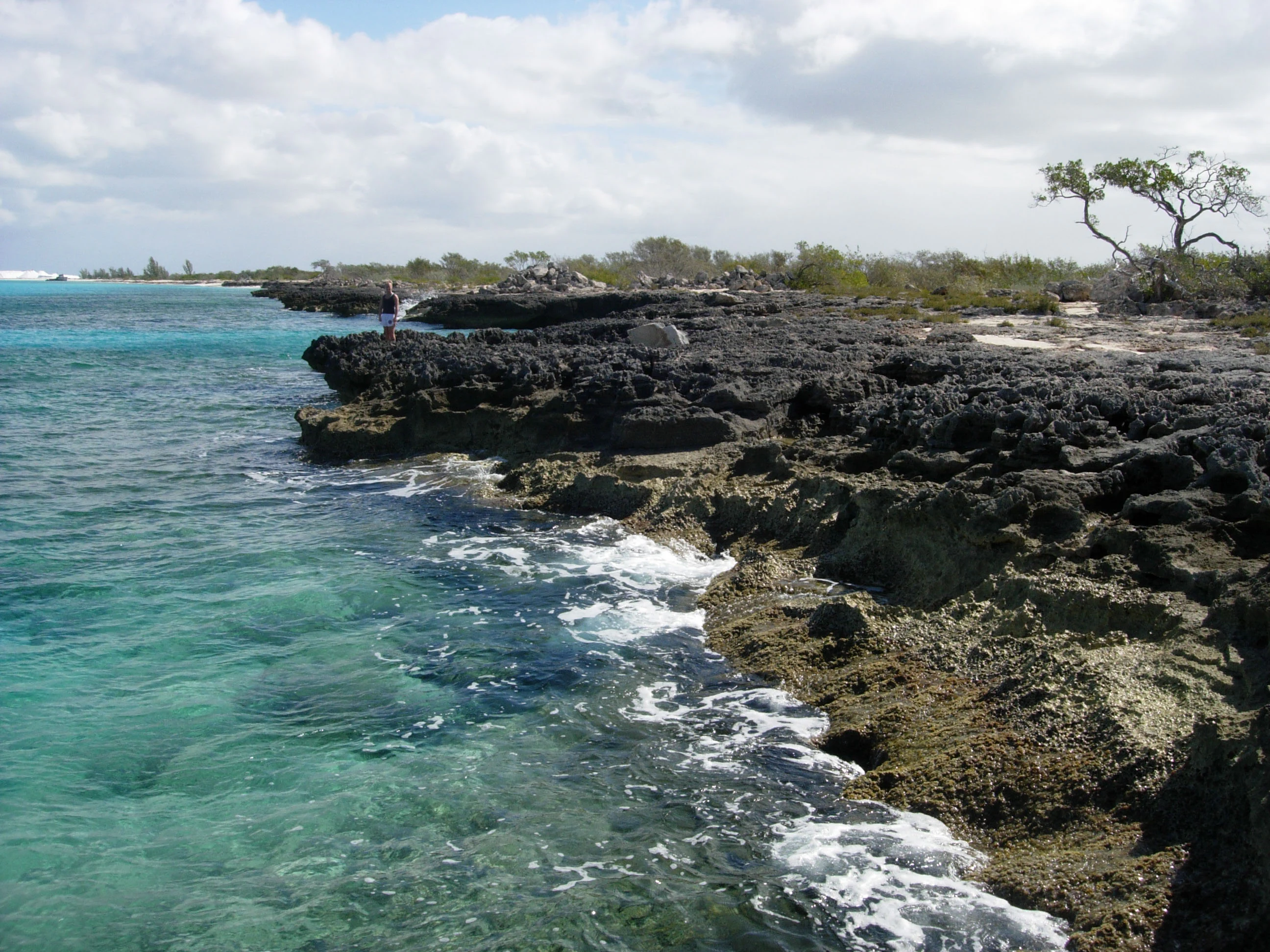
Rocky coastline with turquoise water, white foam, and exposed limestone formations under a partly cloudy sky.
Northern rocky shore of Great Inagua with clear turquoise water and exposed limestone formations under a partly cloudy sky.

Inagua National Park history and protected-area timeline

Concern about West Indian flamingo populations in the Bahamas dates back to at least 1904, when naturalists and early conservationists recognized the species was declining due to hunting pressure and habitat loss. By the 1960s, these concerns had crystallized into formal conservation action, leading to the formation of the Bahamas National Trust and the creation of Inagua National Park specifically to protect the flamingo breeding grounds. The park's establishment represented the first major step by the Bahamian government to protect its natural heritage systematically. Over the subsequent decades, the park's protected status enabled the flamingo population to recover from near-threatened status to the thriving colony of over 50,000 birds observed today. This conservation success story became a model for Caribbean protected area management. The 1999 Ramsar designation formalized international recognition of the park's wetland values, while the park's influence extended to neighboring islands where bird populations also benefited from the regional conservation focus initiated at Inagua.

Inagua National Park landscape and geographic character

The physical landscape of Inagua National Park is defined by its coastal wetlands and inland water bodies set against low-lying Caribbean terrain. Lake Rosa, the largest saltwater lake in the Bahamas, dominates the park's interior and represents a distinctive hydrological feature in an island nation where freshwater is scarce. The lake's shallow, saline waters support specialized biota and create important feeding areas for waterbirds. Coastal areas of the park feature extensive tidal flats and mangroves that fringe the shoreline, particularly along the northern and eastern coasts of Great Inagua. The interior away from the lake consists largely of dense scrub vegetation known as coppice, with pockets of Caribbean pine occurring on slightly elevated ground. The overall topography remains quite flat, with the highest points barely reaching above sea level, characteristic of the Bahamas' limestone base island formation.

Inagua National Park ecosystems, habitats, and plant life

The ecological character of Inagua National Park centers on its coastal wetland ecosystems, which rank among the most productive and biodiverse habitats in the Caribbean. The shallow, hypersaline conditions of Lake Rosa and the coastal flats create ideal foraging grounds for flamingos and numerous other waterbird species. Mangrove systems fringe the coastline and provide critical nursery habitat for fish and crustaceans while also stabilizing the shore against erosion. The interior coppice forests, though less spectacular than the wetlands, support terrestrial bird species, reptiles, and invertebrates adapted to the dry Caribbean conditions. The park's designation as an Important Bird Area reflects the concentration of significant bird populations that depend on these varied habitats throughout the annual cycle.

Inagua National Park wildlife and species highlights

The West Indian flamingo is the undisputed wildlife icon of Inagua National Park, with the park sheltering the largest and most significant breeding colony of this species in the world. These distinctive pink wading birds gather in vast numbers on the shallow coastal flats and Lake Rosa margins, where they feed on brine shrimp and other aquatic invertebrates. The population's recovery from near-extinction to over 50,000 birds represents one of the Caribbean's great conservation success stories. Beyond flamingos, the park supports remarkable bird diversity including numerous heron and egret species, brown pelicans, frigatebirds, and endemic Caribbean songbirds. The surrounding waters contain marine fish, spiny lobsters, and other species that move between the reef systems and the protected coastal zones.

Inagua National Park conservation status and protection priorities

Inagua National Park represents a cornerstone of Bahamas conservation strategy and holds international significance as a Ramsar Wetland of International Importance designated in 1999. The park's protective framework has been essential to the recovery of the West Indian flamingo, a species that was once severely threatened by hunting and habitat degradation. Beyond protecting the flamingo colony itself, the park has served as a catalyst for broader regional conservation benefits, with bird populations in nearby islands including Mayaguana, Acklins, Crooked Island, Andros, and even Cuba showing improvement as conservation awareness spread from the Inagua model. The Bahamas National Trust's management of the park has emphasized balancing species protection with the ecological integrity of the broader island ecosystem, demonstrating how focused protection of a single species can yield benefits that extend far beyond the original target.

Inagua National Park cultural meaning and human context

Great Inagua has historically been one of the more sparsely populated islands in the Bahamas, and the establishment of the national park in 1965 occurred when the human population remained relatively small. The park's creation did not involve significant displacement of communities, and the local population has generally supported the conservation designation that has brought international attention and some economic benefit through birdwatching tourism. The flamingo holds cultural significance in the Bahamas beyond its ecological value, appearing in art and serving as an iconic representation of the islands' natural heritage.

Top sights and standout views in Inagua National Park

Inagua National Park protects the Caribbean's largest flamingo colony and one of the world's most significant coastal wetland complexes. The park encompasses Lake Rosa, the Bahamas' largest saltwater lake, and provides essential habitat for migratory birds traversing the Atlantic flyway. The successful recovery of the West Indian flamingo from near-extinction to a thriving population of over 50,000 birds stands as a landmark conservation achievement. Visitors can observe flamingos from designated viewing areas, particularly during breeding season when the birds engage in elaborate courtship displays and form dense nesting colonies.

Best time to visit Inagua National Park

The optimal time to visit Inagua National Park for bird observation is during the winter months from November through March, when migratory birds are present in greatest numbers and the flamingo colony is most active. The dry season from December through May generally offers more comfortable conditions for exploration, with lower humidity and reduced chance of rainfall. Summer months bring higher temperatures and the potential for hurricanes, which can affect travel to the relatively remote island. The flamingos are present year-round, but the breeding season from approximately March through June offers the most spectacular viewing opportunities as birds engage in nesting behaviors.

Monthly climate preview

Historical temperature and precipitation baselines spanning three decades of maritime measurements.

Inagua National Park Climate Normals and Monthly Weather Averages

Long-term baseline measurements from a representative coordinate trace a warm maritime cycle with mean monthly temperatures consistently remaining between 25 and 29 degrees Celsius. Exploring the full climatology profile reveals detailed month-by-month precipitation shifts and temperature variations across the year.
Annual mean27 °C
25 °C29 °C
Jan25°
Feb25°
Mar25°
Apr26°
May27°
Jun28°
Jul28°
Aug29°
Sep29°
Oct28°
Nov27°
Dec26°
Warmest month
September

28.6 °C

Coolest month
February

25.1 °C

Wettest month
October

3.4 mm/day

Driest month
February

0.9 mm/day

Park location guide

Geography guide, regional context, and park location map for Inagua National Park

Inagua National Park park geography, regions, and map view in Bahamas

Understand where Inagua National Park sits in Bahamas through a broader geographic reading of the surrounding landscape, nearby location context, and its mapped position within the national park landscape.

How Inagua National Park fits into Bahamas

The Bahamas is an island nation in the Atlantic Ocean, forming part of the Lucayan Archipelago. It consists of more than 3,000 islands, cays and islets located north of Cuba, northwest of Hispaniola, and southeast of Florida. The country gained independence from Britain in 1973 and operates as a constitutional monarchy under King Charles III, with Nassau as its capital and largest city.

Wider geography shaping Inagua National Park in Bahamas

The Bahamas occupies the Lucayan Archipelago in the Atlantic Ocean. The island chain is positioned north of Cuba, northwest of Hispaniola (shared by the Dominican Republic and Haiti), southeast of the US state of Florida, and east of the Florida Keys. The territory spans over 3,000 islands, cays and islets, with the total land area being 13,943 km². The Royal Bahamas Defence Force claims approximately 470,000 km² of surrounding ocean space.

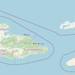
Map view of Inagua National Park

Use this park location map to pinpoint Inagua National Park in Bahamas, understand its exact geographic position, and read its mapped placement within the surrounding landscape more clearly.

Pigeon | © OpenStreetMap contributors

Visual Atlas of Inagua National Park's Wetland Environments, Birdlife, and Caribbean Protected Area Character

Inagua National Park Photos: Explore Landscapes, Habitats, and Iconic Flamingo Scenery

Visually explore the diverse landscapes of Inagua National Park, a crucial Caribbean protected area encompassing expansive coastal wetlands, vast salt lakes like Lake Rosa, and unique island scrubland. Examine detailed imagery to understand the park's distinct terrain, crucial bird habitats, and the striking scenery that supports its renowned West Indian flamingo colony.

Rocky coastline with turquoise water, white foam, and exposed limestone formations under a partly cloudy sky.

Park atlas

Compare coastal wetlands and Caribbean island conservation landscapes across the Bahamas archipelago.

Explore Other National Parks and Protected Areas Near Inagua National Park

Discover other notable protected areas and national parks that share geographic context with Inagua National Park's diverse wetland and island ecosystems. Broaden your atlas-style exploration to compare these distinct Caribbean conservation landscapes, tracing similar coastal features and regional biodiversity.
Protected areaBahamas
About 20 km away#1 closest

Northeast

Union Creek Reserve: Protected Area Landscape and Geographic Context in the Bahamas

Explore the coastal ecosystems and mapped boundaries of Great Inagua

Union Creek Reserve serves as a key protected area within the Bahamas, emphasizing the preservation of its coastal and marine environments on Great Inagua. This entity offers valuable insights into regional geography, showcasing the mapped distribution of protected lands and the ecological significance of Bahamian islands. Its protected status highlights the area's role in conservation within the wider Caribbean atlas of natural landscapes.

IUCN
II
National parkBahamas
About 60 km away#2 closest

Northeast

Little Inagua National Park: Remote Bahamian Protected Landscape & Marine Habitat

Island wilderness, sea turtle nesting, and queen conch larval zones.

Little Inagua National Park, located in the Bahamas, is a remote national park combining terrestrial and marine conservation efforts. This protected area is primarily recognized for its role as a critical nesting site for sea turtles and its importance for queen conch larval development in the surrounding Caribbean waters. Discover the distinct island terrain and shallow marine ecosystems that define this ecologically significant Bahamian protected landscape.

Area
254 km²
Established
2002
IUCN
II
Climate
Tropical
National parkHaiti
About 202 km away#3 closest

Southeast

Three Bays Protected Area National Park: Haiti's Extensive Marine and Coastal Protected Landscape

Mapped coral reefs, mangrove forests, and unique regional geography.

The Three Bays Protected Area in Haiti is a key national park established to conserve its vital marine and coastal environments. Covering over 75,000 hectares, it is the country's largest protected marine complex, encompassing extensive and healthy coral reefs, critical seagrass beds, and sprawling mangrove forests. This protected landscape provides essential ecosystem services and coastal protection, showcasing a significant portion of Haiti's natural heritage and regional geographic context along its northeastern shoreline.

Area
754.06 km²
Established
2014
IUCN
IV
Relief
Lowland
National parkHaiti
About 204 km away#4 closest

Southeast

National History Park National Park: Haiti's Protected Landscape and Geographic Atlas

Discover the park's mapped terrain and protected land geography.

The National History Park serves as a critical protected area within Haiti, offering detailed insights into its unique landscape and geographic setting. As a designated national park, it provides valuable data for atlas-based exploration of protected territories. Users can investigate the park's mapped boundaries, its regional context within Haiti, and the characteristics of its natural terrain, enriching their understanding of conservation landscapes.

Area
25.28 km²
Established
1968
IUCN
IV
Relief
Mountain
National parkNord
About 204 km away#5 closest

Southeast

Parc national historique - Citadelle, Sans Souci, Ramiers: A Caribbean Historic Landscape

Protected mountain terrain and historic fortifications in northern Haiti

This national park protects an expansive mountain massif characterized by the massive Citadelle La Ferrière and the ruins of Sans-Souci Palace. Beyond its architectural significance, the park safeguards essential karst cave networks, natural springs, and forested river corridors that shape the rugged topography of northern Haiti.

Area
252.86 km²
Established
1968
Relief
Mountain
Scope
Terrestrial
National parkMonte Cristi Province
About 218 km away#6 closest

Southeast

Monte Cristi National Park: Dominican Republic National Park Geography and Atlas

Explore mapped boundaries and regional landscape context.

Monte Cristi National Park serves as a vital component of the Dominican Republic's protected lands, located within the Monte Cristi Province. This entry provides essential geographic context and visualizes the park's mapped boundaries, contributing to a comprehensive understanding of its landscape. Delve into the atlas perspective of this national park, examining its terrain and regional significance for structured geographic exploration.

Area
550 km²
Established
1983
IUCN
II
Relief
Upland
National parkDominican Republic
About 285 km away#7 closest

Southeast

José Armando Bermúdez National Park: Dominican Republic National Park Atlas and Landscape Context

Discover the mapped protected area and geographic setting of this Dominican Republic national park.

Gain an understanding of José Armando Bermúdez National Park as a distinct protected landscape within the Dominican Republic. This entry focuses on its role as a national park, providing geographic context and highlighting its mapped boundaries for atlas exploration. Explore the park's specific terrain and its place within the nation's conservation network.

Area
766 km²
Established
1956
IUCN
II
Relief
Mountain
National parkHaiti
About 306 km away#8 closest

South

Deux Mamelles National Park: Protected Cloud Forest and Mountain Terrain in Haiti

Explore Haiti's critical highland cloud forest ecosystem.

Deux Mamelles National Park is a protected area in Haiti renowned for preserving one of the Caribbean's last remaining cloud forest ecosystems. Located on the Tiburon Peninsula, the park centers around Morne Deux Mamelles, a mountain rising to 1,276 meters. Its rugged, dissected limestone terrain supports primary forest at high elevations, making it a significant biodiversity hotspot and a key site for watershed protection. This park offers a glimpse into the unique natural heritage of Haiti's highlands.

Area
22.65 km²
Established
2015
IUCN
II
Relief
Mountain

Common questions about visiting, size, designation, and location context for Inagua National Park

Inagua National Park FAQs for park facts, access, geography, and protected area context

Find quick answers about Inagua National Park, including protected-area facts, park geography, trail and visitor context, and how the park fits into its surrounding country and regional landscape.
MoriAtlas Explorer

Continue Your Protected Areas Search Across the Global Atlas

Deepen your exploration by continuing the structured search for national parks and protected areas worldwide. Utilize the comprehensive filtering capabilities to compare different conservation landscapes and refine your understanding of global park geography. Discover more about the distribution and characteristics of protected natural areas.

Global natural geography