Mori Atlas logo
National parkCorcovado National Park

Mapping the glacial valleys, ancient temperate rainforests, and marine estuaries of southern Chile

Corcovado National Park: A Study in Patagonian Volcanic Terrain and Coastal Wilderness Geography

(Parque Nacional Corcovado)

Corcovado National Park spans over 2,000 square kilometers across the Los Lagos and Aysen regions of Chile, serving as a landmark for large-scale wilderness preservation. This protected landscape is defined by the striking presence of the Corcovado and Yanteles volcanoes, which tower over a complex network of eighty glacial lakes and untouched temperate rainforests. The western boundary intersects the Pacific coastline, where brackish estuaries provide critical nursery habitats for blue whales and diverse marine life within the Gulf of Corcovado.

Volcanic landscapesTemperate rainforestMarine conservationBlue whale habitatGlacial lakesPatagonia

Corcovado National Park

National park

Park overview

Structured park overview, official facts, and landscape profile for Corcovado National Park

Corcovado National Park park facts, protected area profile, and essential visitor context

Review the core facts for Corcovado National Park, including designation, size, terrain, visitor scale, habitats, and operating context in one park-focused overview.

About Corcovado National Park

Corcovado National Park represents a landmark achievement in Chilean conservation history, established through a unique collaboration between private conservation organizations and the Chilean government. The park's creation was catalyzed in 1994 when the Conservation Land Trust (now Tompkins Conservation) purchased a significant 840-square-kilometer parcel of land, followed by diplomatic negotiations that led to the addition of adjacent federal military lands. President Ricardo Lagos formally designated the park in January 2005, making it Chile's fourth-largest national park and the result of a visionary approach to wilderness protection that merged previously disparate land holdings into a cohesive protected landscape. The park stretches across a dramatic landscape shaped by glaciation, featuring deep valleys, towering volcanic peaks, and a coastline along the Gulf of Corcovado that supports both terrestrial and marine ecosystems. Visitors can access the park via a single public trail along the famous Carretera Austral, the scenic highway that threads through this remote corner of Chilean Patagonia.

Quick facts and research context for Corcovado National Park

Located in the Los Lagos Region of Chile, near the town of Chaitén, Corcovado National Park spans roughly 2,096 square kilometers along the Carretera Austral. The park features the iconic volcanoes Corcovado (2,300 meters) and Yanteles (2,042 meters), which dominate the skyline of this coastal wilderness. Created in 2005, it is Chile's fourth-largest national park and represents a successful model of private land acquisition merged with federal territory to establish comprehensive protection. The area contains approximately eighty-two lakes surrounded by ancient forests, with the Bay of Corcovado proposed as Chile's first marine sanctuary to ensure continuous protection from ocean depths to mountain peaks.

Protection and recognition

Examine official terrestrial protection metrics and conservation designations.

Corcovado National Park Protection Status and International Recognition

Corcovado National Park maintains a documented terrestrial protection status within its regional conservation framework. Official records compile available management scope and designation parameters for reliable geographical analysis.

Protection details

Protection scope
Terrestrial
Transboundary protection
No
Park context

Deeper park guide and search-rich context for Corcovado National Park

Corcovado National Park history, landscape, wildlife, and travel context

Explore Corcovado National Park through its history, landscape character, ecosystems, wildlife, conservation priorities, cultural context, and seasonal travel timing in a structured park guide built for atlas discovery and search intent.

Why Corcovado National Park stands out

Corcovado National Park is best known for its dramatic volcanic landscape dominated by the twin peaks of Corcovado and Yanteles volcanoes, which rise sharply above the surrounding temperate rainforest. The park protects one of the world's last remaining pristine wilderness areas, with its extensive network of glacial lakes, old-growth forests, and unspoiled coastlines. The Bay of Corcovado has emerged as a critical habitat for blue whales, making it internationally significant for marine conservation. The park also preserves remarkable biodiversity within its brackish estuaries, where immense colonies of shorebirds congregate and marine mammals including seals, sea lions, and dolphins thrive.

Corcovado National Park history and protected-area timeline

The creation of Corcovado National Park began with a landmark conservation purchase in 1994, when the Conservation Land Trust (now Tompkins Conservation) acquired an 840-square-kilometer parcel of land with funding from philanthropist Peter Buckley. This private land acquisition became the catalyst for a larger vision to establish a national park spanning both private and federal territories. In 2002, Doug Tompkins, founder of Tompkins Conservation, approached President Ricardo Lagos with a proposal: if private lands around Corcovado were donated to the Chilean people, would the government contribute the adjoining federal land to create a new national park? At the time, the federal lands were under the jurisdiction of the Chilean Armed Forces, but both President Lagos and General Juan Emilio Cheyre, the nation's top military officer, recognized that the property was not vital to military readiness and endorsed the concept. Corcovado National Park was formally established by decree in January 2005, largely due to President Lagos's determination to protect this wilderness area. An expedition to climb Cerro Corcovado was documented in the 2010 film 180 Degrees South: Conquerors of the Useless, bringing international attention to this remote landscape.

Corcovado National Park landscape and geographic character

The landscape of Corcovado National Park is defined by its dramatic volcanic terrain and glacial heritage. The iconic Corcovado volcano rises to 2,300 meters above sea level, serving as a dramatic backdrop visible from much of the park and the surrounding coastal areas. The adjacent Yanteles volcano, also known as Yantenes, reaches 2,042 meters and contributes to the rugged skyline of this Patagonian wilderness. Glacial processes have sculpted the terrain, creating a landscape of deep U-shaped valleys, terminal moraines, and numerous lakes. The park contains approximately eighty-two lakes, many surrounded by ancient forests, including Trébol, Jimena, and Escondido in the glacial valleys of the Tictoc river system. The coastline along the Gulf of Corcovado features brackish estuaries where the Corcovado and Tic Toc rivers meet the Pacific, creating a distinctive transition between freshwater and marine environments. The park's western boundary follows the Carretera Austral as it winds through this remote coastal terrain.

Corcovado National Park ecosystems, habitats, and plant life

Corcovado National Park protects exceptional examples of Patagonian temperate rainforest ecosystems. The forest cover is dominated by evergreen species including lenga (Nothofagus pumilio), coigüe de Magallanes (Nothofagus betuloides), and the slow-growing ciprés de las Guaitecas, a conifer that can reach heights exceeding 20 meters. The ciprés de las Guaitecas was historically highly valued for its quality wood, used in furniture and shipbuilding, and much of it survived only because it grew in inaccessible locations that are now protected within the park. The park's biodiversity is remarkable for its concentration of species, with approximately 18 mammal species, 64 bird species, and 133 flora species documented within its boundaries. The brackish estuaries where rivers meet the Gulf of Corcovado represent exceptional wildlife habitat, supporting immense colonies of shorebirds along the beaches and serving as critical feeding and breeding grounds for marine species.

Corcovado National Park wildlife and species highlights

The wildlife of Corcovado National Park reflects the extraordinary ecological diversity of this coastal wilderness. The park's forests are home to pumas, which stalk the shadows of ancient tree stands, along with various fox species and small felines. The region's diverse environments support a rich variety of mammals and birds, with bats including the mouse-eared bat among the nocturnal inhabitants. The coastal waters of the Gulf of Corcovado support marine mammals including South American fur seals, sea lions, dolphins, and orcas. The bay has been discovered to function as a crucial nursery area for blue whales, Earth's largest animals, representing an internationally significant finding for marine conservation. Birdlife is particularly abundant, with the forests hosting species like the cachaña (a type of parakeet), the torcaza (a dove), and the carpintero negro (Magellanic woodpecker), while aquatic environments support species including the pato cuchara (shoveler duck), quetro volador (flightless steamer duck), and garza blanca (great egret). The shores attract immense colonies of shorebirds, and penguins can be observed among the coastal rocks.

Corcovado National Park conservation status and protection priorities

Corcovado National Park represents a pioneering model of conservation in Chile, demonstrating how private land acquisition can leverage publicprotected areas to create large-scale wilderness preserves. The park was created through an innovative public-private partnership that combined private land purchases by Tompkins Conservation with federal lands previously under military jurisdiction, demonstrating the potential for collaborative conservation in South America. The Bay of Corcovado has been proposed as Chile's first marine sanctuary, which would extend protection from the ocean floor to the mountain peaks, creating a comprehensive marine-terrestrial conservation framework. The discovery of the bay's importance as a nursery area for blue whales has elevated the site's international conservation significance, drawing attention to the need for marine protection alongside the existing terrestrial reserves. The park protects one of the planet's last pure wilderness areas, preserving both biodiversity and the ecological processes that sustain these Patagonian ecosystems.

Corcovado National Park cultural meaning and human context

The Bay of Corcovado carries historical significance beyond its ecological value, having once served as a lair for pirates operating along this remote section of the Chilean coast. The region's human history is intertwined with the broader Patagonian story of indigenous communities, Spanish exploration, and later settlement along the Carretera Austral. While the park itself does not contain significant permanent settlements, the surrounding areas of Los Lagos and Aysén regions have been shaped by generations of local communities who have lived in proximity to these dramatic volcanic landscapes. The park's creation represents a modern chapter in this landscape's history, transforming what was previously military territory into a protected wilderness available to all Chilean citizens and international visitors.

Top sights and standout views in Corcovado National Park

Corcovado National Park stands as one of Chile's great wilderness treasures, protecting a landscape of extraordinary volcanic drama with the twin peaks of Corcovado and Yanteles dominating the horizon. The park's over eighty glacial lakes, many ringed by ancient forests where pumas roam, create a landscape of exceptional scenic beauty along the Carretera Austral. The marine waters of the Gulf of Corcovado host blue whales, orcas, dolphins, and colonies of seals, with the bay proposed as Chile's first marine sanctuary. The temperate rainforests of lenga, coigüe, and ciprés de las Guaitecas represent some of the last old-growth forests in this region, preserved for future generations within the park's boundaries.

Best time to visit Corcovado National Park

Corcovado National Park can be visited year-round, though the southern Chilean climate means conditions vary significantly across seasons. Summer months (December through March) offer the longest days and most stable weather, making this the most popular time for visitors seeking to explore the park's trails and scenic viewpoints. Winter brings shorter days and more precipitation, but also offers the dramatic beauty of snow-capped volcanic peaks and the opportunity to experience the park's wilderness character in quieter conditions. The park's location along the Pacific coast means weather systems can move through quickly, and visitors should be prepared for changeable conditions regardless of season. Given the park's limited infrastructure and remote location, planning ahead is essential regardless of when you choose to visit.
Monthly climate preview

Examining representative monthly temperature ranges and precipitation averages across the protected terrain

Corcovado National Park Climate Normals, Long Term Temperature and Precipitation Patterns

Representative baseline coordinates record long term temperature variations and monthly precipitation rhythms across Corcovado National Park. Deeper twelve month climate profiles provide comprehensive weather data for comparative geographical analysis.
Annual mean5 °C
0 °C10 °C
Jan10°
Feb10°
Mar
Apr
May
Jun
Jul
Aug
Sep
Oct
Nov
Dec
Warmest month
February

9.8 °C

Coolest month
July

0.4 °C

Wettest month
June

7.3 mm/day

Driest month
February

2.9 mm/day

Park location guide

Geography guide, regional context, and park location map for Corcovado National Park

Corcovado National Park park geography, regions, and map view in Chile

Understand where Corcovado National Park sits in Chile through a broader geographic reading of the surrounding landscape, nearby location context, and its mapped position within the national park landscape.

How Corcovado National Park fits into Chile

Chile is a presidential republic in western South America, extending as a narrow strip along the western edge of the continent between the Andes Mountains and the Pacific Ocean. It is the southernmost country in the world and the closest to Antarctica. The country is bordered by Peru, Bolivia, and Argentina, and administers several Pacific islands including Easter Island. Chile is a major copper producer and has a population of approximately 19.6 million.

Wider geography shaping Corcovado National Park in Chile

Chile occupies a narrow strip of land along the western edge of South America, extending approximately 4,300 km north to south but only about 350 km east to west at its widest point. The country is sandwiched between the Andes Mountains to the east and the Pacific Ocean to the west. It shares borders with Peru to the north, Bolivia to the northeast, and Argentina to the east. Southern Chile borders the Drake Passage. Chile also administers several Pacific islands including Juan Fernández Islands, Isla Salas y Gómez, Desventuradas Islands, and Easter Island, plus the Chilean Antarctic Territory.

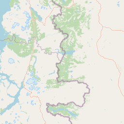
Map view of Corcovado National Park

Use this park location map to pinpoint Corcovado National Park in Chile, understand its exact geographic position, and read its mapped placement within the surrounding landscape more clearly.

Pigeon | © OpenStreetMap contributors

Location context for Corcovado National Park

Los Lagos Region
Natural feature types

Browse the Geographic Features and Natural Landscapes of Corcovado National Park

Deepen your understanding of Corcovado National Park by examining its catalog of named landforms and water bodies. This MoriAtlas collection connects individual geographic markers to the wider Patagonian landscape, facilitating a detailed analysis of the park terrain and its diverse ecological zones.
Recorded earthquake history

Review Recorded Seismic Activity Around Corcovado National Park

Explore the comprehensive MoriAtlas historical record of seismic events documented near Corcovado National Park. This data collection provides an objective look at past recorded activity, highlighting geographic proximity, magnitude, and event timing for the surrounding Patagonian landscape.

Corcovado National Park Earthquake History

Catalogued events

33 events

Strongest magnitude

Magnitude 5.4

Most recent event

Aug 28, 2023

This history includes earthquakes recorded inside the park or within 50 km of its borders

Park atlas

Compare adjacent protected landscapes and regional geography across southern Chile

Explore Other Parks Near Corcovado National Park and Surrounding Wilderness Areas

Browse national parks and protected areas sharing the rugged volcanic terrain and temperate rainforest ecosystems of Corcovado National Park. Continued geographic comparison reveals the broader network of wilderness reserves spanning the surrounding Patagonian region.
Watercolor illustration of a mountainous landscape with green fields and forests under a pale sky
National parkAysén Region
0.6 km away#1 closest

South

Melimoyu National Park: A Key Protected National Park within Chile's Aysén Region

Explore Melimoyu National Park's mapped boundaries and regional geography.

Melimoyu National Park stands as a distinct protected natural area, offering a focused lens for geographic discovery. As a national park situated in the Aysén Region, its mapped boundaries and regional landscape context are crucial for understanding its atlas significance. This entry provides specific details about the park's protected status and its contribution to the mapped terrain of southern Chile, enabling detailed exploration for atlas enthusiasts.

Area
1,055 km²
Established
2018
IUCN
II
Relief
Mixed relief
Watercolor illustration of rolling hills, a river flowing through a valley, and forested areas
National parkAysén del General Carlos Ibáñez del Campo Region
7.3 km away#2 closest

South

Queulat National Park: Patagonian Andes Glacier and Rainforest Discovery

Mapped protected area in Aysén del General Carlos Ibáñez del Campo Region.

Queulat National Park is a vast protected wilderness in southern Chile, renowned for its dramatic glacial alpine terrain and lush temperate rainforests. The park's geography is defined by steep glacial valleys, ice fields, and the iconic Queulat Hanging Glacier cascading from sheer cliffs. Discover the mapped boundaries of this significant Patagonian national park, offering unparalleled insight into its unique ecosystems and dramatic landscapes shaped by ice and forest.

Area
1,541 km²
Established
1983
IUCN
II
Relief
Mountain
Watercolor painting depicting mountains, a lake, and grassy shoreline
National parkArgentina
38 km away#3 closest

Northeast

Los Alerces National Park: Ancient Alerce Forests and Glacial Terrain in Argentina

Discover the park's protected landscape and regional geography.

Los Alerces National Park in Argentina is a globally significant protected area, celebrated for its ancient alerce forests, some of the longest-living trees on Earth. This national park showcases a dramatic landscape shaped by glaciers, featuring a series of interconnected lakes and rugged Andean terrain. Explore the unique ecosystem and mapped geography of this UNESCO World Heritage site to understand its profound natural and conservation value.

Area
2,599 km²
Established
1937
IUCN
II
Relief
Mountain
National parkAysén del General Carlos Ibáñez del Campo Region
42 km away#4 closest

South

Isla Magdalena National Park: Protected Area and Regional Geography Context

Discover the mapped landscape of this national park.

Delve into the protected landscape of Isla Magdalena National Park, a key national park situated in the Aysén del General Carlos Ibáñez del Campo Region of Chile. This entry provides essential geographic context, focusing on the park's mapped boundaries and its role within the Patagonian environment. Understand its distinct identity as a protected area for structured atlas exploration.

Area
1,576 km²
Established
1983
IUCN
II
Relief
Mountain
National parkLos Lagos Region
109 km away#5 closest

Northwest

Chiloé National Park: National Park Discovery and Mapped Boundaries in Los Lagos Region

Explore its unique protected landscape and regional geography.

Chiloé National Park represents a significant protected natural area within the Los Lagos Region of Chile. This detailed page offers an atlas-centric view, focusing on the park's mapped boundaries, its place in the regional geography, and the overall protected landscape character. Gain structured insight into this important component of southern Chile's conservation lands, ideal for geographic exploration and atlas context.

Area
430.57 km²
Established
1983
IUCN
II
Visitors
33.6K annual
National parkLos Lagos Region
112 km away#6 closest

North

Hornopirén National Park: Mapped Protected Landscape and Geographic Identity

Explore the national park's mapped boundaries and regional context.

Hornopirén National Park serves as a crucial protected landscape within Chile's Los Lagos Region. This dedicated park page offers detailed insight into its geographic setting, emphasizing mapped boundaries and its identity as a national park. Users can explore how Hornopirén National Park contributes to the regional geography and protected-area framework, providing a grounded point for landscape discovery.

Area
482 km²
Established
1988
IUCN
II
Relief
Mountain
Watercolor illustration showing a lake surrounded by forested hills and mountains
National parkChubut Province
116 km away#7 closest

Northeast

Lago Puelo National Park: A Unique Protected Landscape at the Intersection of Biomes

Explore its glacial terrain and Andean-Patagonian geographic context.

Lago Puelo National Park, located in Argentina's Chubut Province, stands out as a significant protected area due to its remarkable ecological diversity. This park is distinguished by its rare transition zone where the Patagonian forest converges with the Andean steppe, incorporating flora typically found in the Valdivian temperate rainforest. The mountainous landscape, carved by glaciers, features the striking turquoise waters of Puelo Lake and surrounding river systems. Understanding Lago Puelo National Park's geography provides insight into the complex natural systems of Patagonia and its unique protected biomes.

Area
276.74 km²
Established
1971
IUCN
II
Relief
Mountain
National parkLos Lagos Region
145 km away#8 closest

North

Alerce Andino National Park: Protected Landscape Within Los Lagos Region Geography

Explore the national park's mapped boundaries and regional context.

Delve into the protected landscape of Alerce Andino National Park, a distinct national park entity situated in Chile's Los Lagos Region. This focus provides a clear understanding of its geographic setting, highlighting its importance within regional conservation efforts and offering a detailed view of its mapped terrain. Understand the park's place in the southern Chile geography through this detailed exploration.

Area
393 km²
Established
1982
IUCN
II
Visitors
12.2K annual

Common questions about visiting, size, designation, and location context for Corcovado National Park

Corcovado National Park FAQs for park facts, access, geography, and protected area context

Find quick answers about Corcovado National Park, including protected-area facts, park geography, trail and visitor context, and how the park fits into its surrounding country and regional landscape.
MoriAtlas Explorer

Continue Your Protected Areas Search Across the Global Atlas

Deepen your exploration by continuing the structured search for national parks and protected areas worldwide. Utilize the comprehensive filtering capabilities to compare different conservation landscapes and refine your understanding of global park geography. Discover more about the distribution and characteristics of protected natural areas.

Global natural geography