
Viewpoints
Park geography
Structured data on regional context, terrain relief, and physical environment
Geographic Profile of Corcovado National Park: Mapped Boundaries and Physical Landscapes
Detailed mapping of Corcovado National Park in the Los Lagos Region of Chile covers a sprawling 2,096 square kilometer area. The terrain includes diverse physical features such as the Corcovado Volcano, extensive river networks, coastal zones, and temperate forest habitats, providing a comprehensive overview of the protected land.
Related tags
Volcanic landscapesTemperate rainforestMarine conservationBlue whale habitatGlacial lakes
Chile's wilderness gem protecting volcanic peaks, temperate rainforests, and a critical marine sanctuary for blue whales
Corcovado National Park
Corcovado National Park is a vast wilderness protected area spanning the Los Lagos and Aysén regions of southern Chile, covering approximately 2,096 square kilometers of pristine Patagonian landscape. The park encompasses the dramatic volcanic peaks of Corcovado and Yanteles, over eighty glacial lakes, and extensive tracts of pristine temperate rainforest. Established in 2005 through an innovative public-private partnership between the Chilean government and the Tompkins Conservation organization, it represents one of Chile's largest national parks and one of the last truly untouched wilderness areas on Earth. The park borders the Gulf of Corcovado, where brackish estuaries created by the Corcovado and Tic Toc rivers support extraordinary biodiversity and have been identified as a crucial nursery area for blue whales, the largest animals on the planet.
- Location
- Chile
- Park type
- National park
- Established
- 2005
- Area
- 2,096 km²
Location overview
Administered within Chile and the Los Lagos Region with recorded coastal status
Corcovado National Park Geography and Regional Setting in Chile
Corcovado National Park maintains recorded territorial memberships across Chile and the Los Lagos Region. Administrative records confirm its position as a protected coastal area within the regional network.
- Countries
- Chile
- Regions
- Los Lagos Region
- Primary location
- Chile
- Geographic setting
- Coastal
Boundary and coordinates
Interactive spatial geometry and derived regional area measurements
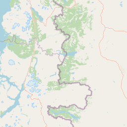
Corcovado National Park Boundary Map and Geographic Extent
Mapped boundary geometry provides reliable spatial context for the protected area. Accompanying measurements detail total recorded area alongside coordinate spans and center coordinates.
- Boundary area
- 3,998.1 km²
- Boundary perimeter
- 631.8 km
- Northernmost point
- 43.0144° S
- Southernmost point
- 44.001° S
- Easternmost point
- 72.3431° W
- Westernmost point
- 73.0908° W
- Geographic centre
- 43.5196° S, 72.6704° W
- North–south span
- 109.6 km
- East–west span
- 60.5 km
Terrain and natural features
Mapped physical geography, volcanoes, glaciers, and coastal capes
Corcovado National Park Terrain, Peaks, Lakes, and Rivers
Mixed mountain park terrain contains numerous recorded peaks, glaciers, rivers, and lakes within boundary limits. Linked feature cards supply official types, names, and spatial relationships for every registered natural landmark.
Selected named natural features
Lakes
Laguna de la Mina
Rivers
Río del Trébol
Capes
Punta Canay
Rivers
None
Rivers
Río Frío
Environmental setting
Temperate climate zones, dominant forest cover, and mixed relief features
Corcovado National Park Environmental Setting and Classification Profile
Recorded landscape features and habitat types outline the physical setting and temperate climate zone of Corcovado National Park. Mapped classifications connect specific environmental categories to relevant regional atlas destinations.
- Relief
- Mixed relief
- Climate
- Temperate
- Water
- Major water bodies
- Forest cover
- Dense forest cover
Landscape features
Mountains · Volcano · Forest · Lakes · Rivers · Wetland · Coast
Habitat types
Temperate broadleaf forest · Wetland · Riverine habitat
Park atlas
Compare adjacent protected landscapes and regional geography across southern Chile
Explore Other Parks Near Corcovado National Park and Surrounding Wilderness Areas
Browse national parks and protected areas sharing the rugged volcanic terrain and temperate rainforest ecosystems of Corcovado National Park. Continued geographic comparison reveals the broader network of wilderness reserves spanning the surrounding Patagonian region.
National parkAysén Region
0.6 km away#1 closest
South

Melimoyu National Park: A Key Protected National Park within Chile's Aysén Region
Explore Melimoyu National Park's mapped boundaries and regional geography.
Melimoyu National Park stands as a distinct protected natural area, offering a focused lens for geographic discovery. As a national park situated in the Aysén Region, its mapped boundaries and regional landscape context are crucial for understanding its atlas significance. This entry provides specific details about the park's protected status and its contribution to the mapped terrain of southern Chile, enabling detailed exploration for atlas enthusiasts.
- Area
- 1,055 km²
- Established
- 2018
- IUCN
- II
- Relief
- Mixed relief
National parkAysén del General Carlos Ibáñez del Campo Region
7.3 km away#2 closest
South
Queulat National Park: Patagonian Andes Glacier and Rainforest Discovery
Mapped protected area in Aysén del General Carlos Ibáñez del Campo Region.
Queulat National Park is a vast protected wilderness in southern Chile, renowned for its dramatic glacial alpine terrain and lush temperate rainforests. The park's geography is defined by steep glacial valleys, ice fields, and the iconic Queulat Hanging Glacier cascading from sheer cliffs. Discover the mapped boundaries of this significant Patagonian national park, offering unparalleled insight into its unique ecosystems and dramatic landscapes shaped by ice and forest.
- Area
- 1,541 km²
- Established
- 1983
- IUCN
- II
- Relief
- Mountain
National parkArgentina
38 km away#3 closest
Northeast

Los Alerces National Park: Ancient Alerce Forests and Glacial Terrain in Argentina
Discover the park's protected landscape and regional geography.
Los Alerces National Park in Argentina is a globally significant protected area, celebrated for its ancient alerce forests, some of the longest-living trees on Earth. This national park showcases a dramatic landscape shaped by glaciers, featuring a series of interconnected lakes and rugged Andean terrain. Explore the unique ecosystem and mapped geography of this UNESCO World Heritage site to understand its profound natural and conservation value.
- Area
- 2,599 km²
- Established
- 1937
- IUCN
- II
- Relief
- Mountain
National parkAysén del General Carlos Ibáñez del Campo Region
42 km away#4 closest
South
Isla Magdalena National Park: Protected Area and Regional Geography Context
Discover the mapped landscape of this national park.
Delve into the protected landscape of Isla Magdalena National Park, a key national park situated in the Aysén del General Carlos Ibáñez del Campo Region of Chile. This entry provides essential geographic context, focusing on the park's mapped boundaries and its role within the Patagonian environment. Understand its distinct identity as a protected area for structured atlas exploration.
- Area
- 1,576 km²
- Established
- 1983
- IUCN
- II
- Relief
- Mountain
National parkLos Lagos Region
109 km away#5 closest
Northwest
Chiloé National Park: National Park Discovery and Mapped Boundaries in Los Lagos Region
Explore its unique protected landscape and regional geography.
Chiloé National Park represents a significant protected natural area within the Los Lagos Region of Chile. This detailed page offers an atlas-centric view, focusing on the park's mapped boundaries, its place in the regional geography, and the overall protected landscape character. Gain structured insight into this important component of southern Chile's conservation lands, ideal for geographic exploration and atlas context.
- Area
- 430.57 km²
- Established
- 1983
- IUCN
- II
- Visitors
- 33.6K annual
National parkLos Lagos Region
112 km away#6 closest
North
Hornopirén National Park: Mapped Protected Landscape and Geographic Identity
Explore the national park's mapped boundaries and regional context.
Hornopirén National Park serves as a crucial protected landscape within Chile's Los Lagos Region. This dedicated park page offers detailed insight into its geographic setting, emphasizing mapped boundaries and its identity as a national park. Users can explore how Hornopirén National Park contributes to the regional geography and protected-area framework, providing a grounded point for landscape discovery.
- Area
- 482 km²
- Established
- 1988
- IUCN
- II
- Relief
- Mountain
National parkChubut Province
116 km away#7 closest
Northeast
Lago Puelo National Park: A Unique Protected Landscape at the Intersection of Biomes
Explore its glacial terrain and Andean-Patagonian geographic context.
Lago Puelo National Park, located in Argentina's Chubut Province, stands out as a significant protected area due to its remarkable ecological diversity. This park is distinguished by its rare transition zone where the Patagonian forest converges with the Andean steppe, incorporating flora typically found in the Valdivian temperate rainforest. The mountainous landscape, carved by glaciers, features the striking turquoise waters of Puelo Lake and surrounding river systems. Understanding Lago Puelo National Park's geography provides insight into the complex natural systems of Patagonia and its unique protected biomes.
- Area
- 276.74 km²
- Established
- 1971
- IUCN
- II
- Relief
- Mountain
National parkLos Lagos Region
145 km away#8 closest
North
Alerce Andino National Park: Protected Landscape Within Los Lagos Region Geography
Explore the national park's mapped boundaries and regional context.
Delve into the protected landscape of Alerce Andino National Park, a distinct national park entity situated in Chile's Los Lagos Region. This focus provides a clear understanding of its geographic setting, highlighting its importance within regional conservation efforts and offering a detailed view of its mapped terrain. Understand the park's place in the southern Chile geography through this detailed exploration.
- Area
- 393 km²
- Established
- 1982
- IUCN
- II
- Visitors
- 12.2K annual
MoriAtlas Explorer
Explore the Geographic Boundaries of Corcovado National Park
Continue mapping the rugged terrain and unique protected ecosystems of Corcovado National Park. MoriAtlas provides a structured look at the volcanic peaks, glacial valleys, and coastal waters that define this expansive Chilean wilderness area for researchers and geographic enthusiasts.
Browse next
Global natural geography
Explore related park routes
Explore MoriAtlas Global ParksBrowse All MoriAtlas ParksGlobal Park Map DiscoveryMoriAtlas: Browse All CountriesBrowse All MoriAtlas ContinentsNational Park Environment AtlasGrand Canyon National Park AtlasYellowstone National Park AtlasYosemite National Park Atlas and GeographySerengeti National Park AtlasGalápagos National Park Protected LandscapeBanff National Park Geography and AtlasKruger National Park Atlas EntryUluṟu-Kata Tjuṯa National Park AtlasExplore Uluru-Kata Tjuta National Park GeographyPlitvice Lakes National Park AtlasFiordland National Park Protected LandscapeGreat Smoky Mountains National Park AtlasAfghanistan National Parks and Protected AreasAlbania National Parks and Protected AreasAlgeria National Parks and Protected AreasAmerican Samoa National Parks and Protected AreasAndorra National Parks and Protected AreasAngola National Parks and Protected AreasAntarctica National Parks and Protected AreasAntigua and Barbuda Park List