
Streams
Park geography
Mapped boundaries, mountain relief, and diverse environmental landscape classifications
Comprehensive Geographic and Terrain Profile of Darién National Park in Panama
The geography of Darién National Park spans 5790 square kilometers of mountainous terrain, dense forest, and coastal wetlands within Darién Province. This profile details the mapped boundaries and natural features including significant peaks such as Cerro Tacarcuna and various river systems flowing through this tropical protected area.
Related tags
Tropical RainforestUNESCO World Heritage SiteBird WatchingIndigenous CommunitiesContinental Divide
The impenetrable wilderness where North and South America meet
Darién National Park
Darién National Park is a vast protected wilderness in eastern Panama that represents one of the most significant ecological and geographical landmarks in Central America. Spanning approximately 5,790 square kilometers, it forms a critical natural bridge connecting the continents of North and South America. The park is located in Darién Province, with its southern boundary stretching along roughly 90 percent of the Colombia-Panama border. Established in 1980 and designated a UNESCO World Heritage Site in 1981, it stands as Panama's largest national park and one of the most important protected areas in the region. The park's remote and rugged character has preserved an extraordinary diversity of ecosystems, from Pacific coastal beaches and mangrove swamps to dense tropical forests and mountainous terrain.
- Location
- Panama
- Park type
- National park
- Established
- 1980
- Area
- 5,790 km²
Location overview
Regional boundaries and marine coastlines of Darién Province
Geographic Profile of Darién National Park in Panama
Darién National Park is located within Panama's Darién Province, anchoring the region's geographic landscape. Verified geographic records track its designation as a transboundary, coastal, and marine protected area.
- Countries
- Panama
- Regions
- Darién Province
- Primary location
- Darién Province
- Geographic setting
- Transboundary · Coastal · Marine
Boundary and coordinates
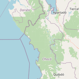
Visualizing the spatial extent and 5,790 square kilometer area
Darién National Park Geographic Boundary Map and Spatial Limits
The interactive boundary geometry offers clear spatial context for the protected area. Accompanying regional metrics define the total area of 5,790 square kilometers along with geographic center coordinates and spans.
- Boundary area
- 5,531.3 km²
- Boundary perimeter
- 808 km
- Northernmost point
- 8.5406° N
- Southernmost point
- 7.2223° N
- Easternmost point
- 77.1586° W
- Westernmost point
- 78.4486° W
- Geographic centre
- 7.8254° N, 77.7035° W
- North–south span
- 145.8 km
- East–west span
- 142.3 km
Terrain and natural features
Mountain classification and recorded river and peak records
Darién National Park Terrain and Named Natural Features
Mountain terrain classifications structure the protected landscape alongside recorded rivers and peaks located within the boundary. Associated feature cards document names, types, and spatial relationships for each entry.
Selected named natural features
Rivers
Río Setegantí
Rivers
Rio Caquena
Rivers
Rio Uruganti
Peaks
Cerro Gandi
1,155 m
Peaks
Cerro Quía
1,362 m
Environmental setting
Analysis of tropical habitats, dominant forest cover, and relief types
Environmental Setting and Landscape Classifications of Darién National Park
Recorded classifications frame the physical setting through interconnected tropical habitats, mountain reliefs, and coastal features. Associated categories link directly to relevant atlas destinations across the protected geography.
- Relief
- Mountain
- Climate
- Tropical
- Water
- Major water bodies
- Forest cover
- Dense forest cover
Landscape features
Mountains · Forest · Wetland · Coast · Beach · Cliffs
Habitat types
Tropical forest · Wetland · Coastal habitat · Marine habitat
Park atlas
Trace the broader protected landscapes, diverse ecosystems, and regional park geography connected to this Central American landmark.
Discover Nearby National Parks and Protected Areas Beyond Darién National Park in Panama
Continue your exploration of Central America's protected areas by browsing other national parks and protected landscapes within the surrounding region of Darién National Park. Comparing adjacent protected regions helps reveal the unique biodiversity, varied terrain, and critical conservation efforts across Panama and its neighboring countries, offering a richer geographic context.
National parkColombia
Park boundaries overlap#1 closest
East

Los Katíos National Natural Park: Colombia National Park Protected Landscape
Geographic context and mapped terrain for a key Colombian conservation area.
Delve into Los Katíos National Natural Park, a designated National Park in Colombia, to understand its unique protected landscape and its place within the country's broader geography. This detailed view supports atlas exploration, enabling a clear grasp of the park's mapped boundaries and natural terrain for a structured approach to discovering protected areas.
- Area
- 720 km²
- Established
- 1974
- IUCN
- II
- Relief
- Mixed relief
Wildlife reserveColombia
About 14 km away#2 closest
North
Playona Acandí Fauna and Flora Sanctuary: Colombia's Wildlife Reserve Atlas and Protected Landscape
Explore protected area boundaries and natural terrain.
Delve into the geographic identity of Playona Acandí Fauna and Flora Sanctuary, a protected wildlife reserve in Colombia. This destination offers detailed mapping of its protected landscape, providing context for its natural terrain and its significance within the national atlas of conservation areas. Understand the specific geographic features that define this important wildlife sanctuary.
- Area
- 262.32 km²
- Relief
- Lowland
- Climate
- Tropical
- Scope
- Mixed
Wildlife reserveGuna Yala
About 148 km away#3 closest
Northwest

Nargana Wilderness Area: Protected Landscapes of the Guna Yala Caribbean Slope
A vertical transect of tropical rainforest and mountain terrain
The Nargana Wilderness Area represents a significant wildlife reserve in Panama, encompassing 954 square kilometres of diverse tropical ecosystems. Stretching from sea level to the San Blas ridge, the reserve showcases a continuous sequence of coastal lowlands and submontane habitats. This indigenous-governed region offers a unique geographic study of forest stratification and ecological connectivity along the Continental Divide, providing a protected mosaic of habitats that are essential to the broader Guna Yala landscape.
- Area
- 954.14 km²
- Established
- 1994
- Relief
- Mountain
- Climate
- Tropical
National parkChocó Department
About 153 km away#4 closest
South
Utría National Natural Park: National Park Protected Landscape and Geography
Explore its mapped boundaries and regional context in Chocó.
As a designated national park, Utría National Natural Park offers a unique lens for understanding Colombia's protected landscapes. This entry provides essential geographic context, detailing the park's location within the Chocó Department and highlighting its significance as a mapped natural area. Discover the protected boundaries and regional landscape character through structured atlas data.
- Area
- 543.8 km²
- Established
- 1987
- IUCN
- II
- Relief
- Mountain
National parkPanama
About 158 km away#5 closest
Northwest
Metropolitan Natural Park: Urban Protected Area and Forest Geography in Panama
Tracing the boundaries of a rare city-based wildlife refuge
Metropolitan Natural Park offers a significant study of urban conservation in Panama, protecting 265 hectares of Pacific tropical dry forest. Situated along the Panama Canal watershed, the terrain provides essential forest connectivity and diverse microhabitats, serving as a critical sanctuary within the dense metropolitan fabric of Panama City.
- Area
- 2.65 km²
- Established
- 1985
- IUCN
- II
- Relief
- Upland
Wildlife reservePanama City
About 158 km away#6 closest
Northwest
Metropolitan Natural Park: Protected Tropical Forest in Panama City
Mapping the Pacific watershed and urban wildlife corridors
Metropolitan Natural Park stands as a rare wildlife refuge, protecting a dense secondary tropical dry forest ecosystem inside the capital. The park boundary encompasses forested slopes and ridgelines that look out over the Panama Canal, providing a unique intersection of intact biodiversity and urban geography.
- Area
- 2.65 km²
- Established
- 1985
- Relief
- Lowland
- Climate
- Tropical
National parkColombia
About 160 km away#7 closest
East
Paramillo National Natural Park: Colombia's National Park Geographic Identity and Protected Landscape
Mapped protected area within Colombia's natural geography.
Gain a structured understanding of Paramillo National Natural Park, a significant protected landscape within Colombia. This detailed entry focuses on the park's geographic context, its role as a national park, and its mapped boundaries. It serves as a crucial reference point for exploring Colombia's diverse protected areas and understanding their placement within the nation's regional geography.
- Scope
- Terrestrial
National parkColón Province
About 173 km away#8 closest
Northwest
Soberanía National Park: Panama National Park Atlas, Geography, and Protected Landscape Details
Explore the mapped boundaries and regional geography of this national park.
Investigate Soberanía National Park, a designated national park situated in Panama's Colón Province. This entry offers detailed geographic context, focusing on its mapped protected area, landscape character, and role within regional conservation. Understand the spatial distribution and atlas significance of this protected land, essential for a structured geographic discovery of Panama's natural heritage.
- Area
- 220 km²
- Established
- 1980
- IUCN
- II
- Relief
- Lowland
MoriAtlas Explorer
Continue Exploring Darién National Park's Geography and Map Context
Delve deeper into the structured geographic data and mapped landscape of Darién National Park. Understanding its precise boundaries and regional context is fundamental for anyone exploring protected areas and natural landscapes within Darién Province. This park detail page provides the essential foundation for further atlas-based study of this significant Panamanian national park.
Browse next
Global natural geography
Explore related park routes
Explore MoriAtlas Global ParksBrowse All MoriAtlas ParksGlobal Park Map DiscoveryMoriAtlas: Browse All CountriesBrowse All MoriAtlas ContinentsNational Park Environment AtlasGrand Canyon National Park AtlasYellowstone National Park AtlasYosemite National Park Atlas and GeographySerengeti National Park AtlasGalápagos National Park Protected LandscapeBanff National Park Geography and AtlasKruger National Park Atlas EntryUluṟu-Kata Tjuṯa National Park AtlasExplore Uluru-Kata Tjuta National Park GeographyPlitvice Lakes National Park AtlasFiordland National Park Protected LandscapeGreat Smoky Mountains National Park AtlasAfghanistan National Parks and Protected AreasAlbania National Parks and Protected AreasAlgeria National Parks and Protected AreasAmerican Samoa National Parks and Protected AreasAndorra National Parks and Protected AreasAngola National Parks and Protected AreasAntarctica National Parks and Protected AreasAntigua and Barbuda Park List