

Mori Atlas logo
National parkMetropolitan Natural Park

Understanding the urban landscape, forest ecosystems, and watershed geography of this protected wilderness.

Metropolitan Natural Park: A Rare Tropical Dry Forest Protected Area in Panama City

(Parque Natural Metropolitano)

Metropolitan Natural Park represents a unique case of ecological preservation within Panama City, functioning as the only wildlife refuge situated inside the capital's urban boundaries. Covering 265 hectares, this protected area preserves a rare remnant of Pacific tropical dry forest that once defined the surrounding regional geography. The landscape encompasses rolling terrain within the Panama Canal watershed, providing a critical natural habitat that bridges urban development and preserved tropical ecosystems.

Urban protected areaTropical dry forestBirdwatching destinationPacific rainforest ecosystemPanama Canal watershedCity wildlife refuge

Metropolitan Natural Park

National park

Park overview

Structured park overview, official facts, and landscape profile for Metropolitan Natural Park

Metropolitan Natural Park park facts, protected area profile, and essential visitor context

Review the core facts for Metropolitan Natural Park, including designation, size, terrain, visitor scale, habitats, and operating context in one park-focused overview.

About Metropolitan Natural Park

Metropolitan Natural Park occupies a distinctive position as the sole protected natural area within Panama City's metropolitan zone. The park was conceived through a gradual process beginning in 1974, when initial steps were taken to preserve green space near the Panama Canal corridor. The area was initially designated as the Curundú Recreational Area in 1983, and following a presidential visit in 1975 that recognized the area's ecological potential, formal plans for a metropolitan natural park were developed. Law No. 8 of July 5, 1985 established the park officially, and it was inaugurated on June 5, 1988. The park's location in the district of Panama, corregimiento of Ancón places it along Juan Pablo II Avenue, where it serves as a critical ecological corridor and green lung for the capital. The park's management balances urban recreation with conservation objectives, maintaining trails and facilities while protecting the natural ecosystems that define its identity.

Quick facts and research context for Metropolitan Natural Park

Metropolitan Natural Park spans 265 hectares along Juan Pablo II Avenue in the Ancón corregimiento of Panama City. The park protects a rare tropical dry forest ecosystem of the Pacific region, an environment that has nearly vanished from other parts of Panama. It hosts 227 bird species, 45 mammal species, 36 snake species, and 14 amphibian species, along with approximately 284 plant species. The protected area was formally created through Law No. 8 on July 5, 1985, making it one of Panama's newer national parks while representing an important urban conservation initiative.

Protection and recognition

Review documented terrestrial protection metrics and official international recognition records.

Metropolitan Natural Park Protection Status and Designated Conservation Scope

Metropolitan Natural Park maintains a documented terrestrial protection scope governed by official designation frameworks. Conservation records compile verified management details and recognition parameters without assuming external outcomes.

Protection details

Protection scope
Terrestrial
Park context

Deeper park guide and search-rich context for Metropolitan Natural Park

Metropolitan Natural Park history, landscape, wildlife, and travel context

Explore Metropolitan Natural Park through its history, landscape character, ecosystems, wildlife, conservation priorities, cultural context, and seasonal travel timing in a structured park guide built for atlas discovery and search intent.

Why Metropolitan Natural Park stands out

Metropolitan Natural Park is best known as Panama City's only wildlife refuge, offering a rare opportunity to experience tropical rainforest ecosystems within an urban setting. The park protects one of the last remaining tracts of Pacific tropical dry forest in Panama, an ecosystem that has been largely eliminated from the country. Its remarkable biodiversity includes nearly 230 bird species, making it a significant destination for birdwatching. The park also features nature trails that traverse forests, offer panoramic views of the capital skyline, and provide access to the Panama Canal watershed area.

Metropolitan Natural Park history and protected-area timeline

The establishment of Metropolitan Natural Park emerged from a multi-year process recognizing the need for environmental protection near Panama City's urban core. Initial conservation discussions began in 1974, focusing on the optimal use of land in the area adjacent to the Panama Canal. By 1983, the territory received its first formal protection status as the Curundú Recreational Area, acknowledging its recreational and ecological value. The critical转折 point came in 1975 when President Jorge Illueca toured the area and subsequently approved a proposal for creating a dedicated metropolitan natural park. This proposal, designated as PNM3, laid the groundwork for formal protection. The park was ultimately created through Law No. 8 of July 5, 1985, and officially opened on June 5, 1988, becoming Panama City's primary natural protected area within its urban boundaries.

Metropolitan Natural Park landscape and geographic character

Metropolitan Natural Park features terrain characteristic of the Panamanian isthmus, situated along the watershed that feeds into the Panama Canal. The park's 265 hectares encompass rolling terrain typical of Pacific slope forests, with elevation changes that create diverse microhabitats throughout the protected area. Despite its urban location, the park maintains a natural landscape dominated by tropical dry forest vegetation. Nature trails wind through the forest, offering visitors views of both the natural environment and panoramic perspectives of Panama City's skyline. The landscape represents a rare preserved remnant of the Pacific-side tropical dry forest that historically covered much of the region before urban expansion transformed the surrounding areas.

Metropolitan Natural Park ecosystems, habitats, and plant life

The park protects a critically important tropical dry forest ecosystem of the Pacific region, an environment that has nearly disappeared from other parts of Panama due to agricultural conversion and urban development. Approximately 75% of the park's area is covered by this tropical dry forest type, representing one of the most significant remaining examples of this ecosystem in the country. The forest supports a rich plant community of approximately 284 species, including diverse trees, climbing vines, epiphytes, orchids, and mosses. The park's location within the Panama Canal watershed adds ecological significance, as it helps protect water quality and provides ecosystem services to one of the world's most important maritime corridors. The proximity to urban development makes the preservation of this ecological island particularly valuable for maintaining biodiversity within the metropolitan area.

Metropolitan Natural Park wildlife and species highlights

Metropolitan Natural Park supports remarkably diverse wildlife despite its urban setting, with the park recording 227 bird species, 45 mammal species, 36 snake species, and 14 amphibian species. The bird population includes macaws and numerous other tropical species typical of Panamanian rainforests. Mammals found in the park include monkey species such as marmosets, as well as the ñeque (a type of agouti) and various squirrel species. This biodiversity is particularly notable given the park's location within a major metropolitan area, demonstrating how protected green spaces can maintain significant ecological value even when surrounded by urban development. The wildlife community benefits from the park's forest habitat, which provides food sources, shelter, and movement corridors within the urban landscape.

Metropolitan Natural Park conservation status and protection priorities

Metropolitan Natural Park represents an important urban conservation achievement, protecting the last significant tracts of Pacific tropical dry forest within the Panama City metropolitan area. The park's designation as the only wildlife refuge within the capital underscores its unique conservation value in a rapidly urbanizing region. By protecting an ecosystem that has nearly vanished from other parts of the country, the park serves as a living archive of Panama's original Pacific forest flora and fauna. The protected area also contributes to the broader Panama Canal watershed management framework, helping maintain ecological functions that support the canal's operations. This urban protected area demonstrates how conservation can be integrated with metropolitan development, providing wildlife habitat, ecosystem services, and environmental education opportunities within a major city.

Metropolitan Natural Park cultural meaning and human context

While Metropolitan Natural Park is primarily an ecological preserve, it occupies land within the Ancón corregimiento, an area with historical significance in Panama's development. The park's establishment reflected growing environmental awareness in Panama during the 1970s and 1980s, a period when the country began systematically addressing conservation needs alongside economic development associated with the Panama Canal. The park provides environmental education opportunities for Panama City's population, allowing residents to experience native ecosystems without traveling to more distant protected areas. This access to natural environments within the city carries cultural value, particularly as urban development continues to transform the Panamanian landscape.

Top sights and standout views in Metropolitan Natural Park

Metropolitan Natural Park offers visitors a unique combination of accessible wilderness within a major capital city. The park's trail network provides opportunities to observe tropical dry forest ecosystems, spot diverse bird species, and enjoy panoramic views of Panama City's skyline. As the only wildlife refuge in Panama City, it serves a distinctive role in the nation's protected area system, demonstrating how urban conservation can preserve significant biodiversity. The nearly 230 bird species recorded within the park make it particularly valuable for birdwatching enthusiasts. The park's location along Juan Pablo II Avenue makes it easily accessible while maintaining its protected status.

Best time to visit Metropolitan Natural Park

The park can be visited year-round, though the dry season from December through April typically offers more comfortable conditions for trail exploration. During the wet season, trails may be muddier and some routes could be more challenging, though the forest appears lusher and waterfalls may be more active. Early morning visits generally offer the best wildlife viewing opportunities, particularly for birdwatching when forest birds are most active. The dry season corresponds with Panama's peak tourist season, so visitors seeking quieter park experiences might consider weekday mornings. Regardless of season, the park provides a meaningful nature experience that showcases Panama's tropical ecosystems within an urban context.
Monthly climate preview

Long-term monthly temperature ranges and precipitation patterns across the protected landscape

Metropolitan Natural Park Climate Normals, Annual Temperature and Precipitation Rhythm

Metropolitan Natural Park records consistent thermal conditions alongside distinct shifts in monthly precipitation totals from dry to wet periods. Examining the complete twelve-month profile provides deeper insight into measured climate baselines across the representative coordinate.
Annual mean27 °C
26 °C28 °C
Jan26°
Feb27°
Mar27°
Apr28°
May28°
Jun27°
Jul27°
Aug27°
Sep27°
Oct27°
Nov27°
Dec27°
Warmest month
April

28.1 °C

Coolest month
January

26.5 °C

Wettest month
September

8 mm/day

Driest month
February

0.4 mm/day

Park location guide

Geography guide, regional context, and park location map for Metropolitan Natural Park

Metropolitan Natural Park park geography, regions, and map view in Panama

Understand where Metropolitan Natural Park sits in Panama through a broader geographic reading of the surrounding landscape, nearby location context, and its mapped position within the national park landscape.

How Metropolitan Natural Park fits into Panama

Panama is a presidential republic located at the southern end of Central America in North America. It gained independence from Spain in 1821 and from Colombia in 1903, the latter enabling the construction of the Panama Canal under U.S. supervision between 1904 and 1914. The canal was transferred to Panamanian control in 1999 following the Torrijos-Carter Treaties. With a population of approximately 4.3 million and an area of about 75,400 km², Panama has a high-income economy driven primarily by canal tolls, banking, commerce, and tourism.

Wider geography shaping Metropolitan Natural Park in Panama

Panama is located at the southern end of the Central American isthmus, stretching from the Caribbean coast in the north to the Pacific coast in the south. The country shares land borders with Costa Rica to the west and Colombia to the southeast. The terrain consists of coastal plains, mountain ranges including the Cordillera Central and Cordillera de Talamanca, and river valleys. The Panama Canal bisects the country, connecting the Atlantic and Pacific Oceans.

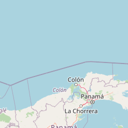
Map view of Metropolitan Natural Park

Use this park location map to pinpoint Metropolitan Natural Park in Panama, understand its exact geographic position, and read its mapped placement within the surrounding landscape more clearly.

Pigeon | © OpenStreetMap contributors

Location context for Metropolitan Natural Park

Panamá Province
Park atlas

Compare adjacent rainforests and regional reserves across the Panama Canal watershed

Other Protected Areas and Parks Near Metropolitan Natural Park

Continue exploring tropical dry forest reserves and regional protected landscapes after reviewing Metropolitan Natural Park. Examining adjacent conservation areas provides a broader perspective on the biodiversity and geographic terrain shaping the surrounding region.
Wildlife reservePanama City
Mapped park locations coincide#1 closest

Metropolitan Natural Park: Protected Tropical Forest in Panama City

Mapping the Pacific watershed and urban wildlife corridors

Metropolitan Natural Park stands as a rare wildlife refuge, protecting a dense secondary tropical dry forest ecosystem inside the capital. The park boundary encompasses forested slopes and ridgelines that look out over the Panama Canal, providing a unique intersection of intact biodiversity and urban geography.

Area
2.65 km²
Established
1985
Relief
Lowland
Climate
Tropical
National parkColón Province
About 16 km away#2 closest

Northwest

Soberanía National Park: Panama National Park Atlas, Geography, and Protected Landscape Details

Explore the mapped boundaries and regional geography of this national park.

Investigate Soberanía National Park, a designated national park situated in Panama's Colón Province. This entry offers detailed geographic context, focusing on its mapped protected area, landscape character, and role within regional conservation. Understand the spatial distribution and atlas significance of this protected land, essential for a structured geographic discovery of Panama's natural heritage.

Area
220 km²
Established
1980
IUCN
II
Relief
Lowland
National parkPanamá Province
About 46 km away#3 closest

North

Chagres National Park: National Park Protected Landscape Atlas

Discover geographic boundaries and natural terrain context.

Chagres National Park is a crucial protected area situated in Panamá Province, Panama. This page serves as an atlas-style gateway to understanding its specific geographic identity, mapped boundaries, and the surrounding natural terrain. It is designed for users seeking detailed insights into the park's protected landscape and its contribution to regional geography and conservation mapping efforts.

Area
1,290 km²
Established
1985
IUCN
II
Relief
Upland
National parkPanamá Oeste Province
About 54 km away#4 closest

Southwest

Altos de Campana National Park: National Park Protected Landscape and Geographic Context

Mapped boundaries and regional geography in Panamá Oeste Province.

Gain a structured understanding of Altos de Campana National Park, a designated national park located in Panamá Oeste Province. This page details its identity as a protected landscape, offering insights into its geographic placement and mapped boundaries for comprehensive atlas-style exploration. Understand its regional context and its contribution to Panama's network of protected areas.

Area
48.16 km²
Established
1966
IUCN
II
Relief
Mountain
Wildlife reserveGuna Yala
About 94 km away#5 closest

Northeast

Nargana Wilderness Area: Protected Landscapes of the Guna Yala Caribbean Slope

A vertical transect of tropical rainforest and mountain terrain

The Nargana Wilderness Area represents a significant wildlife reserve in Panama, encompassing 954 square kilometres of diverse tropical ecosystems. Stretching from sea level to the San Blas ridge, the reserve showcases a continuous sequence of coastal lowlands and submontane habitats. This indigenous-governed region offers a unique geographic study of forest stratification and ecological connectivity along the Continental Divide, providing a protected mosaic of habitats that are essential to the broader Guna Yala landscape.

Area
954.14 km²
Established
1994
Relief
Mountain
Climate
Tropical
National parkPanama
About 123 km away#6 closest

West

Omar Torrijos "El Cope" National Park: Mapped Boundaries and Protected Landscape in Panama

Explore the geographic setting and natural terrain of this Panamanian national park.

Omar Torrijos "El Cope" National Park is a designated protected area offering rich opportunities for geographic discovery. Users can explore its mapped boundaries, understand its place within Panama's natural landscapes, and gain insight into the park's regional geographic context. This page provides a structured atlas-style view, highlighting the park's identity as a significant protected landform within Central America.

IUCN
II
Scope
Terrestrial
National parkHerrera Province
About 146 km away#7 closest

Southwest

Sarigua National Park: A Protected National Park Landscape in Herrera Province

Explore mapped boundaries and regional geographic context.

Sarigua National Park represents a significant protected area within Herrera Province, Panama. This page details its identity as a national park, emphasizing its mapped geography and the regional context it inhabits. Users seeking to understand the specific protected landscape, its boundaries, and its place within the broader atlas of natural areas will find comprehensive discovery-oriented content.

IUCN
II
Relief
Lowland
Climate
Tropical
Access
Access unknown
National parkDarién Province
About 158 km away#8 closest

Southeast

Darién National Park: Darién Province National Park Geographic and Map Exploration

Discover its protected landscape and regional geographic context.

Darién National Park serves as a key protected area within Darién Province, offering an essential focus for geographic and atlas-based discovery. This dedicated park detail page provides insights into its mapped boundaries and its significance as a national park. Users can explore the park's specific geographic footprint and its place within the regional landscape, facilitating a structured understanding of protected natural areas. Dive into the mapped terrain and conservation landscape context that defines Darién National Park for comprehensive atlas exploration.

Area
5,790 km²
Established
1980
IUCN
II
Relief
Mountain

Common questions about visiting, size, designation, and location context for Metropolitan Natural Park

Metropolitan Natural Park FAQs for park facts, access, geography, and protected area context

Find quick answers about Metropolitan Natural Park, including protected-area facts, park geography, trail and visitor context, and how the park fits into its surrounding country and regional landscape.
MoriAtlas Explorer

Continue Your Protected Areas Search Across the Global Atlas

Deepen your exploration by continuing the structured search for national parks and protected areas worldwide. Utilize the comprehensive filtering capabilities to compare different conservation landscapes and refine your understanding of global park geography. Discover more about the distribution and characteristics of protected natural areas.

Global natural geography