Mori Atlas logo
National parkDinder National Park

Discover the mapped boundaries and landscape context of this national park in Sudan.

Dinder National Park: Sudan National Park Protected Area and Geographic Map

Dinder National Park stands as a significant protected landscape within the geography of Sudan. As a national park, its mapped boundaries and regional context are essential for understanding conservation areas in Northeast Africa. This entry offers detailed geographic insights, focusing on the park's physical presence and its role within Sudan's diverse terrain, providing a foundation for atlas-driven discovery.

National ParkBiosphere ReserveRamsar WetlandSavannahRiverine ForestTransboundary Protected Area

Dinder National Park

National park

Park overview

Structured park overview, official facts, and landscape profile for Dinder National Park

Dinder National Park park facts, protected area profile, and essential visitor context
Review the core facts for Dinder National Park, including designation, size, terrain, visitor scale, habitats, and operating context in one park-focused overview.

About Dinder National Park

Dinder National Park represents one of Sudan’s most significant protected areas and serves as a vital ecological corridor connecting the Horn of Africa’s wildlife populations. The park's strategic location along the Dinder River, approximately 400 kilometers southeast of Khartoum, creates a ribbon of fertile habitat穿过 the semi-arid landscape that characterizes much of eastern Sudan. The protected area extends to the Ethiopian border, where it connects seamlessly with Alitash National Park, establishing a transboundary conservation network that allows wildlife to move freely across an otherwise fragmented landscape. The town of Dinder, situated 93 kilometers to the northwest, serves as the primary gateway for visitors entering the park, providing essential infrastructure and access to this remote wilderness area.

The park's ecological significance stems largely from its position at the juncture of two major biogeographical regions. The Sahel zone to the north gives way to the Ethiopian Highlands in the south and east, creating a complex mosaic of habitats that supports species adapted to both environments. This transitional character makes Dinder ecologically distinctive, as it contains elements of both ecosystems and supports species assemblages found nowhere else in Sudan. The riverine forests along the Dinder River, the woodland savannahs, and the oxbow lakes known locally as mayas each provide specialized habitats that together create one of the most biodiverse regions in the country.

Quick facts and research context for Dinder National Park

Dinder National Park covers 10,000 km² of eastern Sudan, located roughly 400 km southeast of Khartoum along the Dinder River. The park was established in 1935 and expanded westward by 2,630 km² in 1983. It holds dual designation as a biosphere reserve (1979) and Ramsar Wetland (2005). The park contains three distinct ecosystems: riverine riparian zones along the Dinder River, woodland habitats, and oxbow lakes locally called mayas. The protected area connects to Ethiopia's Alitash National Park, forming a transboundary conservation zone.

Park context

Deeper park guide and search-rich context for Dinder National Park

Dinder National Park history, landscape, wildlife, and travel context
Explore Dinder National Park through its history, landscape character, ecosystems, wildlife, conservation priorities, cultural context, and seasonal travel timing in a structured park guide built for atlas discovery and search intent.

Why Dinder National Park stands out

Dinder National Park is best known as a critical ecotone between the Sahel and Ethiopian Highlands, a biogeographical meeting point that supports remarkable species diversity. The park hosts 27 large mammal species including lions, leopards, and cheetahs, along with over 160 bird species and 32 fish species. It sits on a major Eurasian-African bird migration flyway. The riverine woodland ecosystem around the Dinder River and its oxbow lakes provides crucial habitat in an otherwise semi-arid landscape, while the park's status as a biosphere reserve recognizes its role in sustaining ecological processes essential to regional environmental health.

Dinder National Park history and protected-area timeline

The history of human occupation and abandonment in the Dinder area reflects the broader environmental and political transformations that have shaped eastern Sudan over the past century and a half. When European explorers first visited the region in 1861, the area around Dinder supported a substantial human population engaged in traditional agricultural and pastoral activities. This population disappeared during the tumultuous 1880s, a decade marked by the Mahdist War and catastrophic famine that devastated communities throughout Sudan. By the time explorer Alfred Harrison traveled through the area in 1925, he found only traces of the former settlements, the landscape returned to a wilder state that would eventually become the foundation for the national park.

Dinder was formally established as a protected area in 1935, following the London Convention of 1933 which established frameworks for preserving wildlife in their natural state across African colonies. This early designation placed Dinder among the pioneering protected areas of colonial Africa. In 1979, the park was admitted to the World Network of Biosphere Reserves, recognizing its importance for conserving ecological processes while allowing for sustainable human use of surrounding lands. The park boundaries were significantly expanded in 1983, adding approximately 2,630 square kilometers to the western portion of the reserve. This expansion reflected growing recognition of the ecological connectivity between the core protected area and the wider landscape necessary to maintain viable wildlife populations.

Dinder National Park landscape and geographic character

The physical landscape of Dinder National Park is defined by the Dinder River, which flows through the protected area from south to north before joining the Blue Nile system. The river creates a riparian corridor of exceptional ecological importance, bordered by riverine forest that provides shade, water, and habitat in stark contrast to the surrounding semi-arid plains. Beyond the river valley, the park encompasses woodland savannah characterized by scattered trees and seasonal grasslands that transform dramatically with the rainy season. The distinctive oxbow lakes, locally called mayas, formed when the river changed course, dot the landscape and provide permanent water sources that attract wildlife throughout the dry season.

The terrain across the park varies from relatively flat floodplains along the river to more undulating ground in the woodland zones. The boundary to the north follows the Rahad River, another major watercourse that contributes to the hydrological complexity of the region. The park's position at approximately 12°N latitude places it squarely in the transition zone between the Sahel's seasonal rainfall patterns and the more consistently humid conditions of the Ethiopian Highlands. This geographic position shapes every aspect of the landscape, from the vegetation patterns to the seasonal availability of water and the types of wildlife that can survive in this challenging environment.

Dinder National Park ecosystems, habitats, and plant life

The ecological character of Dinder National Park is defined by its position as a transitional zone between two major African biomes, creating a complex mosaic of habitats that supports exceptional biodiversity. The park contains three distinct ecosystem types that work together to sustain the region's wildlife: the riverine or riparian ecosystem along the Dinder River and its tributaries provides dense vegetation and permanent water; the woodland ecosystem covers the majority of the park's extent with varying density and species composition; and the maya or oxbow lake ecosystem creates isolated wetlands that serve as critical dry-season refuges. This combination of habitats within a relatively compact protected area makes Dinder one of Sudan’s most ecologically diverse regions.

The park's location on the bird migration flyway between Eurasia and Africa adds an avian dimension to its ecological significance. During migration seasons, the park becomes a vital stopover for countless birds traveling between continents, while resident species exploit the diverse habitats year-round. The river system supports fish populations that in turn sustain predator species and provide livelihoods for local communities. The transitional position between Sahel and Ethiopian Highlands also means the park contains plant species from both regions, creating unusual ecological assemblages found nowhere else in the world.

Dinder National Park wildlife and species highlights

Dinder National Park supports an impressive diversity of wildlife, with 27 species of large mammals recorded within its boundaries. The park is home to a healthy population of Central African lions, along with leopards and cheetahs that prey on the abundant ungulates throughout the park. The ungulate community includes tiang, Roan antelope, waterbuck, and reedbuck, though populations of these species have faced significant pressure in recent decades. The North African ostrich roams the more open areas of the park, while smaller mammals including various rodents, bats, and other small species complete the mammalian community.

The avian community is equally remarkable, with over 160 bird species recorded in the park. This diversity reflects both the resident bird populations that have adapted to the various habitats and the migratory species that pass through on the major flyway connecting Eurasia and Africa. Waterfowl concentrate around the oxbow lakes and river channels, while raptors patrol the skies above the woodland. The park also supports 32 fish species in its waters, sustaining both aquatic predators and providing an important resource for the broader ecosystem. Reptiles and amphibians complete the vertebrate community, though detailed inventories of these groups remain incomplete.

Dinder National Park conservation status and protection priorities

Dinder National Park faces significant conservation challenges that threaten its ecological integrity despite its protected status. The primary threat stems from agricultural expansion that encroaches on traditional grazing lands, displacing pastoral communities and their livestock into the park boundaries. This process is driven by regional population growth that increases demand for both cultivated land and grazing areas, creating pressure on the park's boundaries and resources. The conversion of migration corridors outside the park into farmland has particularly severe consequences for migratory species that rely on access to seasonal grazing areas.

Population surveys reveal the scale of the challenge: between 1971 and 2001, game counts documented dramatic declines in most large mammal species. Waterbuck populations fell by 85%, reedbuck by 72%, and oribi by 68%, indicating a conservation crisis unfolding within the protected area. Several species that once inhabited the park have been completely extirpated, including the African bush elephant, black rhinoceros, hippopotamus, tora hartebeest, Nubian giraffe, Soemmerring's gazelle, and Nile crocodile. The painted hunting dog, an endangered canid, still occurs in the park but has declined significantly. The dual designation as a biosphere reserve and Ramsar Wetland provides international recognition and some protection, but the park requires enhanced management capacity to address these threats effectively.

Dinder National Park cultural meaning and human context

The Dinder region carries the imprint of human history stretching back centuries, though the current landscape reflects a relatively recent abandonment of intensive human occupation. The area was heavily populated when first visited by Europeans in 1861, with communities engaged in agriculture and pastoralism supported by the river's resources. The catastrophic events of the 1880s, including the Mahdist War and devastating famine, emptied the region of its human population, allowing the land to recover and eventually become protected. The park's establishment in 1935 institutionalized the transition from human-dominated landscape to wildlife sanctuary, though surrounding communities maintain connections to the land through traditional practices.

Top sights and standout views in Dinder National Park

Dinder National Park stands out as Sudan’s premier protected area through its combination of ecological significance, biodiversity, and international recognition. The park's position on the Sahel-Ethiopian Highlands ecotone creates unique habitats that support species from both regions. The riverine ecosystem along the Dinder River provides a green corridor through semi-arid terrain, supporting wildlife populations that would otherwise be impossible in this climate zone. With 27 large mammal species, over 160 birds, and 32 fish species, the park offers exceptional biological diversity. The transboundary connection to Ethiopia's Alitash National Park establishes a conservation network of international significance. The dual designation as biosphere reserve and Ramsar Wetland recognizes the park's global importance, while the history of human abandonment and subsequent recovery demonstrates both the vulnerability and resilience of ecosystems in this region.

Best time to visit Dinder National Park

The optimal time to visit Dinder National Park aligns with the dry season, typically from November through April, when wildlife concentrates around the remaining water sources in the river and oxbow lakes. The landscape is more accessible during this period, with reduced vegetation allowing better wildlife viewing opportunities. However, the park can be visited year-round, with the wet season from June to September transforming the environment with new growth and migratory bird arrivals. The shoulder seasons of October and May offer a balance between conditions, though access may be affected by seasonal road conditions. The gateway town of Dinder provides the most practical base for park visits, though advance planning is essential given the remote location and limited infrastructure.

Park location guide

Geography guide, regional context, and park location map for Dinder National Park

Dinder National Park park geography, regions, and map view in Sudan
Understand where Dinder National Park sits in Sudan through a broader geographic reading of the surrounding landscape, nearby location context, and its mapped position within the national park landscape.

How Dinder National Park fits into Sudan

Sudan is a large African nation spanning 1.89 million km² in Northeast Africa with a population of approximately 51.8 million people. It is Africa's third-largest country by area and is governed as a federal republic with Khartoum as its capital and largest city.

Wider geography shaping Dinder National Park in Sudan

Sudan is located in Northeast Africa with coastline along the Red Sea. It shares borders with Egypt to the north, Libya to the northwest, Chad to the west, the Central African Republic to the southwest, South Sudan to the south, and Eritrea and Ethiopia to the southeast.

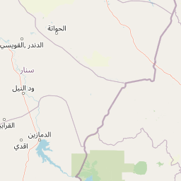
Map view of Dinder National Park

Use this park location map to pinpoint Dinder National Park in Sudan, understand its exact geographic position, and read its mapped placement within the surrounding landscape more clearly.

Pigeon | © OpenStreetMap contributors
Park atlas

Explore the broader regional geography and connected conservation landscapes surrounding Dinder National Park

Discover Nearby National Parks and Protected Areas Beyond Dinder National Park
After exploring Dinder National Park, browse other national parks and protected areas across its surrounding regional geography, including transboundary conservation landscapes and diverse ecotone environments. Compare these protected sites to understand the wider distribution of savannah and riverine forest ecosystems in Eastern Africa and gain valuable atlas context.
National parkNorth Gondar Zone

Alitash National Park: Protected Lowland Woodland & Savanna Landscape

Explore the geographic context of this Ethiopian National Park.

Alitash National Park serves as a vital protected area within Ethiopia's North Gondar Zone, encompassing 2,665.7 square kilometers of distinct lowland woodland and savanna ecosystems. The park's landscape is characterized by gently undulating terrain, seasonal river valleys, and the prominent Twin Mountains of Amadog. Its mapped boundaries delineate an area rich in biodiversity, highlighting its significance as a national park for conservation efforts. Understanding Alitash National Park's geographic setting is key to appreciating its role in regional ecological preservation and atlas exploration.

Area
2,665.7 km²
Established
2006
IUCN
II
Relief
Upland
National parkAmhara Region

Simien Mountains National Park: National Park Protected Landscape and Regional Geography

Explore Amhara Region's distinct mountain terrain and park boundaries.

Simien Mountains National Park serves as a key protected landscape within the Amhara Region of Ethiopia. This national park offers a distinct geographic identity, characterized by its unique terrain and mapped natural boundaries. Understanding this park provides valuable context for regional geography and the broader atlas of protected areas in northern Ethiopia.

Area
412 km²
Established
1969
IUCN
II
Visitors
26K annual
National parkEthiopia

Didessa National Park: Protected River Valley Landscape in Ethiopia's Western Highlands

Discover dramatic escarpments, forested terrain, and waterfalls.

Explore Didessa National Park, a protected area in western Ethiopia notable for its dramatic topographical features. This national park showcases a striking landscape of steep escarpments flanking the Didessa River valley, supporting lush forest ecosystems. Key features include numerous waterfalls that contribute to the park's distinctive terrain and ecological significance. Understanding Didessa National Park offers insight into Ethiopia's protected lands and their unique geographic attributes.

Area
1,300 km²
Established
2017
IUCN
II
Relief
Lowland
National parkAfar Region

Yangudi Rassa National Park: Protected Semi-Desert National Park in Afar Region

Mapped landscape and dryland ecosystems.

Yangudi Rassa National Park represents a critical protected area within Ethiopia's Afar Region, covering extensive semi-desert and grassland terrains. The park's geography is marked by Mount Yangudi and the broad Rassa Plains, with the Awash River shaping its riverine forests and marshes. This national park offers a unique insight into dryland ecosystems and their conservation, providing a distinct mapped landscape for geographic study and exploration.

Area
4,731 km²
Established
1969
IUCN
II
Relief
Mixed relief
National parkEthiopia

Awash National Park: Mapped Protected Boundaries and Ethiopian Regional Geography

Discover the protected landscape of this Ethiopian National Park.

Awash National Park represents a significant protected area within Ethiopia, offering a rich focus for geographic discovery. This page illuminates the park's specific mapped boundaries and its positioning within the surrounding regional geography. It serves as a detailed entry point for understanding the park's landscape character and its role as a national park in East Africa.

Area
850 km²
Established
1966
IUCN
II
Relief
Mixed relief
National parkSouth West Ethiopia Peoples' Region

Chebera Churchura National Park: Ethiopia's National Park Protected Landscape Explorer

Mapping the protected area and regional geography of Chebera Churchura.

Chebera Churchura National Park is a key protected landscape in the South West Ethiopia Peoples' Region, designated as a national park. This page provides detailed geographic context and atlas-level information about the park's boundaries and its place within the regional terrain. Engage with the structured data that defines Chebera Churchura National Park's identity as a significant natural area for map-based discovery.

Area
1,250 km²
Established
2006
IUCN
II
Climate
Tropical
National parkOromia Region

Abijatta-Shalla National Park: Protected National Park within Oromia Region

Mapped landscape and regional geographic context.

Delve into the protected landscape identity of Abijatta-Shalla National Park, a designated national park situated within the Oromia Region. This dedicated detail page offers an atlas-driven perspective, focusing on the park's geographic scope, mapped terrain, and its significance as a protected natural area. Understand its role in the broader context of Ethiopian protected lands and regional geography.

Area
887 km²
Established
1974
IUCN
II
Relief
Mountain
National parkArsi Zone

Arsi Mountains National Park: Protected Ethiopian Highlands Landscape & Geography

Mapped protected terrain and endemic species habitat within the Arsi Zone.

Arsi Mountains National Park is a vast protected area celebrated for its significant biodiversity and distinctive Afro-alpine ecosystems. Situated in the Arsi Zone, this national park encompasses a dramatic mountain landscape central to the Ethiopian Highlands. It serves as a crucial refuge for endangered endemic species, including the mountain nyala and Ethiopian wolf, within its varied ecological zones and protected park boundaries, offering rich context for geographic exploration.

Area
10,876 km²
Established
2011
IUCN
II
Relief
Mountain

Common questions about visiting, size, designation, and location context for Dinder National Park

Dinder National Park FAQs for park facts, access, geography, and protected area context
Find quick answers about Dinder National Park, including protected-area facts, park geography, trail and visitor context, and how the park fits into its surrounding country and regional landscape.
MoriAtlas Explorer

Continue Your Protected Areas Search Across the Global Atlas

Deepen your exploration by continuing the structured search for national parks and protected areas worldwide. Utilize the comprehensive filtering capabilities to compare different conservation landscapes and refine your understanding of global park geography. Discover more about the distribution and characteristics of protected natural areas.

Global natural geography