
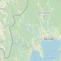
Straits
Park geography
Structured landscape data and spatial attributes for the islands of Djurö National Park
Comprehensive Geographic Profile and Mapped Boundaries of Djurö National Park in Sweden
Djurö National Park covers 24 square kilometers of lake and island terrain in Västra Götaland County, Sweden. This geographic profile details the park's 19-kilometer boundary, spatial span, and associated natural features including Kässan, Långön, and various island formations within Lake Vänern.
Lake archipelago sanctuary in Sweden's largest lake
Djurö National Park
Djurö National Park is a unique island nature reserve situated in Lake Vänern, Sweden's largest lake, located in Västra Götaland County in southwestern Sweden. The park encompasses a complete archipelago of approximately 35 islands covering 24 square kilometers, established in 1991 under Swedish government proposition 1990/91:31. The park represents one of Sweden's rare lake-based national parks, protecting a distinctive archipelago ecosystem that rises from the open waters of Vänern rather than a coastal marine environment. The islands have been sparsely inhabited since the 1500s, with the archipelago once supporting up to three families at its population peak, though it is now uninhabited except for a hunting lodge and an unmanned lighthouse. This isolation has allowed the natural ecosystems to develop relatively undisturbed, creating a sanctuary for diverse wildlife and a living example of inland archipelago ecology in Sweden.
- Location
- Sweden
- Park type
- National park
- Established
- 1991
- Area
- 24 km²
Location overview
Mapped regional boundaries and island status in Västra Götaland
Exploring the Island Geography of Djurö National Park in Sweden
Map the regional placement of Djurö National Park within the borders of Västra Götaland County in Sweden. As a protected island park, the area features isolated geographic status without transboundary or marine classifications.
- Countries
- Sweden
- Regions
- Västra Götaland County
- Primary location
- Västra Götaland County
- Geographic setting
- Inland · Island
Boundary and coordinates
Spatial outline and map coordinates for the 24 square kilometer area
Djurö National Park Boundary Map and Geographic Dimensions
Mapped boundary geometry provides essential spatial context for Djurö National Park. Accompanying datasets detail the calculated area, estimated perimeter, coordinates, and geographic center of the protected zone.
- Boundary area
- 23.2 km²
- Boundary perimeter
- 19.3 km
- Northernmost point
- 58.8764° N
- Southernmost point
- 58.8232° N
- Easternmost point
- 13.5143° E
- Westernmost point
- 13.4053° E
- Geographic centre
- 58.8468° N, 13.4652° E
- North–south span
- 5.9 km
- East–west span
- 6.3 km
Terrain and natural features
Stored terrain classifications and recorded within park features
Djurö National Park Terrain and Named Natural Features Atlas
Recorded named natural features include lakes, bays, islands, and forests situated directly within the park boundary. Linked feature cards supply specific types and spatial relationships for every cataloged landmark.
Selected named natural features
Islands
Lilla Rågholmen
Lakes
Vänern
44 m
Bays
Timmerviken
Islands
Malbergsholmen
Bays
Malen
Environmental setting
Temperate climate zones, mixed relief, and major water bodies across islands
Environmental Setting and Habitat Classifications of Djurö National Park
Stored habitat categories, landscape features, and sparse forest cover provide structured context for the physical setting of Djurö National Park. Recorded classifications link directly to relevant atlas destinations to support broader environmental exploration.
- Relief
- Mixed relief
- Climate
- Temperate
- Water
- Major water bodies
- Forest cover
- Sparse forest
Landscape features
Islands · Lakes · Woodland · Grassland
Habitat types
Temperate broadleaf forest · Grassland · Coastal habitat · Riverine habitat
Park atlas
Examine the geographic context and protected-area spread across Västra Götaland County, expanding from Djurö National Park.
Compare National Parks and Protected Areas Surrounding Djurö National Park in Västra Götaland County
After delving into Djurö National Park's lake archipelago, explore a curated list of other national parks and protected areas within Västra Götaland County and surrounding Swedish geography. Expand your understanding of regional conservation landscapes, comparing diverse ecosystems and mapped terrain beyond this unique island sanctuary.
National parkSweden
62 km away#1 closest
East

Tiveden National Park: Sweden's Protected Granite Landscape and Ancient Forest
Explore protected wilderness, fracture valleys, and geological heritage.
Tiveden National Park is a protected area in southern Sweden renowned for its ancient forests and rugged granite landscape. The park's terrain features deep fracture valleys, formed by ancient geological events, and stands as one of the last large remnants of older forest in the region. Discover the park's unique topography, mapped boundaries, and its significance as a protected natural landscape for atlas-based exploration.
- Area
- 20.3 km²
- Established
- 1983
- IUCN
- II
- Relief
- Mixed relief
National parkÖrebro County
91 km away#2 closest
Northeast
Garphyttan National Park: Pioneer Protected Landscape and Historic Swedish Terrain
Explore meadows, forests, and historic geography in Örebro County.
Garphyttan National Park, established in 1909, is a testament to early Swedish nature conservation efforts. This protected landscape features rolling forested terrain and distinctive flower-rich meadows, maintained through traditional practices that highlight Sweden's cultural heritage. Located within Örebro County, the park offers valuable insights into regional geography and the formation of mapped protected areas, making it a key destination for understanding historical landscape preservation.
- Area
- 1.11 km²
- Established
- 1909
- IUCN
- II
- Relief
- Lowland
National parkVästra Götaland County
95 km away#3 closest
West
Tresticklan National Park: Preserved Old-Growth Forest on Rocky Heathland
Explore the geographic context and mapped boundaries of this vital protected area.
Tresticklan National Park is a vital protected landscape in Västra Götaland County, Sweden, safeguarding one of southern Scandinavia's most significant old-growth forest ecosystems. The park's terrain is defined by exposed granite bedrock, sparse heath pine forests, and a wild, remote character. MoriAtlas provides a structured overview of Tresticklan National Park, detailing its geographic setting and protected area status for explorers and cartographers.
- Area
- 28.97 km²
- Established
- 1996
- IUCN
- II
- Relief
- Upland
National parkVästra Götaland County
128 km away#4 closest
West
Kosterhavet National Park: A Marine National Park Exploring Unique Archipelago Geography
Discover its mapped underwater terrain and rich marine biodiversity.
Kosterhavet National Park, located in Västra Götaland County, is Sweden's first marine national park, dedicated to protecting the unique aquatic environment of the Koster Islands. This protected area is renowned for its exceptional marine biodiversity, including rare cold-water coral reefs and the country's largest seal colony, all situated within a dramatic underwater geography characterized by deep fjords. Use MoriAtlas to explore the mapped extent of this vital marine protected landscape and understand its significant place in regional and national conservation efforts.
- Area
- 388.78 km²
- Established
- 2009
- IUCN
- II
- Visitors
- 90K annual
National parkØstfold
135 km away#5 closest
West

Ytre Hvaler National Park: Norway's Coastal Marine Protected Landscape Atlas
Explore protected archipelago geography and unique cold water coral reefs.
Discover Ytre Hvaler National Park, a pivotal marine protected area on Norway's Østfold coast. This atlas entry provides detailed insight into its defining skerry landscape, the significant Tisler cold water coral reef, and its role as a protected marine ecosystem. Understand the mapped boundaries and geographic context of this unique Norwegian coastal wilderness, crucial for understanding the region's natural and maritime heritage.
- Area
- 354 km²
- Established
- 2009
- IUCN
- II
- Climate
- Temperate
National parkJönköping County
167 km away#6 closest
South
Store Mosse National Park: Explore Sweden's Largest Bog Landscape & Protected Area
Detailed park map, geography, and peatland ecosystem context.
Delve into Store Mosse National Park, a significant protected landscape in Jönköping County, Sweden, celebrated for its vast peat bog, the largest south of Lapland. This page provides detailed geographic context, mapping its unique wetland terrain, interspersed lakes like Kävsjön, and surrounding pine forests. Understand the park's ecological importance as a Ramsar site and its place within the South Småland peneplain for structured natural area discovery.
- Area
- 78.5 km²
- Established
- 1982
- IUCN
- II
- Relief
- Lowland
National parkFærder Municipality
About 169 km away#7 closest
West
Færder National Park: Norway's Coastal Archipelago & Marine Protected Area Atlas
Explore mapped landscapes and regional geography.
Færder National Park represents a significant protected landscape in Norway, characterized by its extensive marine environment and scattered archipelago. Situated east of Færder Municipality, the park's geography is defined by a mosaic of granite islands, coastal waters, and the iconic Færder Lighthouse. This entry provides atlas-level insight into the park's mapped boundaries, its role as a protected coastal ecosystem, and its contribution to the broader regional geography of Norway's southern coast.
- Area
- 340 km²
- Established
- 2013
- IUCN
- II
- Relief
- Lowland
National parkKalmar County
170 km away#8 closest
Southeast
Norra Kvill National Park: Ancient Coniferous Forest Protected Landscape in Kalmar County
Discover its unique mapped terrain and natural forest heritage.
Norra Kvill National Park safeguards a remarkable old-growth coniferous forest ecosystem, a rarity in southern Sweden. This park is characterized by ancient pines, some dating back over 350 years, thriving on steep fault-formed terrain and amid boulder fields. Its protected status ensures the preservation of this unique natural landscape, providing invaluable insight into forest ecology and regional geography within Kalmar County. MoriAtlas offers a structured approach to understanding its mapped boundaries and ecological significance.
- Area
- 1.14 km²
- Established
- 1927
- IUCN
- II
- Relief
- Highland
MoriAtlas Explorer
Continue Exploring Djurö National Park's Unique Geographic Identity
Delve deeper into the structured geographic data and mapped context of Djurö National Park. Understanding this lake archipelago national park offers a unique perspective on Sweden's aquatic protected landscapes. Continue your atlas exploration to discover how Djurö National Park's boundaries and island formations contribute to its distinctive environmental profile within Västra Götaland County and the broader region.
Browse next
Global natural geography
Explore related park routes
Explore MoriAtlas Global ParksBrowse All MoriAtlas ParksGlobal Park Map DiscoveryMoriAtlas: Browse All CountriesBrowse All MoriAtlas ContinentsNational Park Environment AtlasGrand Canyon National Park AtlasYellowstone National Park AtlasYosemite National Park Atlas and GeographySerengeti National Park AtlasGalápagos National Park Protected LandscapeBanff National Park Geography and AtlasKruger National Park Atlas EntryUluṟu-Kata Tjuṯa National Park AtlasExplore Uluru-Kata Tjuta National Park GeographyPlitvice Lakes National Park AtlasFiordland National Park Protected LandscapeGreat Smoky Mountains National Park AtlasAfghanistan National Parks and Protected AreasAlbania National Parks and Protected AreasAlgeria National Parks and Protected AreasAmerican Samoa National Parks and Protected AreasAndorra National Parks and Protected AreasAngola National Parks and Protected AreasAntarctica National Parks and Protected AreasAntigua and Barbuda Park List