Mori Atlas logo
National parkParque nacional Dr. José Gregorio Hernández

Mapping the geographic corridor and high-altitude watershed ecosystems in Trujillo

Parque nacional Dr. José Gregorio Hernández: A Protected Andean Mountain Landscape

Parque nacional Dr. José Gregorio Hernández serves as a vital ecological bridge within the Venezuelan Andes, connecting regional reserves through its complex Andean terrain. This protected area safeguards high-altitude páramo and cloud forest environments that support endangered spectacled bear populations and maintain the headwaters of the Santo Domingo and Calderas river systems.

Andean parkvenezuelan Andesspectacled bear habitatcloud forestparamomountain corridor

Parque nacional Dr. José Gregorio Hernández

National park

Park overview

Structured park overview, official facts, and landscape profile for Dr. José Gregorio Hernández National Park

Dr. José Gregorio Hernández National Park park facts, protected area profile, and essential visitor context

Review the core facts for Dr. José Gregorio Hernández National Park, including designation, size, terrain, visitor scale, habitats, and operating context in one park-focused overview.

About Dr. José Gregorio Hernández National Park

Dr. José Gregorio Hernández National Park occupies a strategic position in the Venezuelan Andes, straddling the borders of Trujillo, Mérida, and Barinas states. The terrain combines steep mountain slopes, cloud forests, páramo grasslands, and high-elevation ridgelines typical of the northern Andes, with elevations reaching approximately 4,000 meters above sea level. The park's geography places it at the heart of one of the most ecologically important mountain systems in northern South America.

The park is named in honor of Dr. José Gregorio Hernández, a celebrated Venezuelan physician, but the protected landscape itself is often referred to as the Ramal de Calderas, a name that reflects the local Andean context and its connection to the Calderas river watershed. Established through presidential decree on August 1, 2021, the park was formally recognized after years of scientific advocacy by ecologists including Edgar Yerena and Marcos Hidalgo, whose research demonstrated the area's exceptional biodiversity value.

From a conservation perspective, the park's most critical role is its function as a wildlife corridor. It connects Guaramacal National Park to the north with the Sierra Nevada de Mérida to the south, allowing the movement of wide-ranging species such as the spectacled bear across a continuous stretch of Andean habitat. The park also protects the headwaters of the Santo Domingo and Calderas rivers, both of which are vital for downstream water supply and hydroelectric generation.

Administratively, the park covers approximately 55 percent of the Boconó municipality and 79 percent of the Pueblo Llano municipality, giving it a major presence in the daily environmental and territorial reality of these Andean communities. Within its boundaries lies part of the Teta de Niquitao-Guirigay Natural Monument, reinforcing the layered protection status of the area and its importance for Venezuela's broader system of natural reserves.

Quick facts and research context for Dr. José Gregorio Hernández National Park

Dr. José Gregorio Hernández National Park is a Venezuelan national park administered by INPARQUES and established on August 1, 2021. It spans the borders of the states of Trujillo, Mérida, and Barinas, covering roughly 505 square kilometers of Andean landscape at elevations reaching around 4,000 meters above sea level. The nearest recognized locality is Pueblo Llano.

The park functions as a biological corridor between Guaramacal National Park and the Sierra Nevada de Mérida, two of the most important protected areas in the Venezuelan Andes. Its designation was supported by extensive field research led by Venezuelan biologist Edgar Yerena and researcher Marcos Hidalgo, along with a broader team of ecologists.

Protection and recognition

Documented protection history and official international recognition records

Parque nacional Dr. José Gregorio Hernández Protection Status and Recognition

Protected area records for Parque nacional Dr. José Gregorio Hernández outline documented conservation measures and management scope. Structured conservation data details official designation metrics and international recognition frameworks.

Protection details

Transboundary protection
No
Park context

Deeper park guide and search-rich context for Dr. José Gregorio Hernández National Park

Dr. José Gregorio Hernández National Park history, landscape, wildlife, and travel context

Explore Dr. José Gregorio Hernández National Park through its history, landscape character, ecosystems, wildlife, conservation priorities, cultural context, and seasonal travel timing in a structured park guide built for atlas discovery and search intent.

Why Dr. José Gregorio Hernández National Park stands out

The park is best known for protecting one of the largest remaining habitats of the spectacled bear (oso frontino) in Venezuela, a vulnerable Andean species that is rarely observed in the wild. Its Andean cloud forests and páramo ecosystems offer the kind of remote, rugged terrain where these bears can still find refuge. Equally significant is the park's role as a high-altitude corridor between Guaramacal and the Sierra Nevada de Mérida. By linking these two major reserves, it strengthens landscape connectivity across the Venezuelan Andes and supports the long-term viability of populations of rare and endemic species that depend on contiguous forest cover.
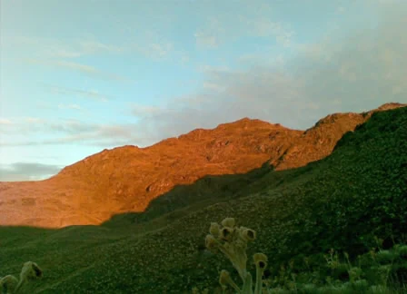
A mountainous landscape showing the peak of Teta de Niquitao, with golden sunlight hitting the rocky slopes while the lower green slopes remain in shadow.
The Teta de Niquitao peak catching the golden light in Dr. José Gregorio Hernández National Park.

Dr. José Gregorio Hernández National Park history and protected-area timeline

The protected area that would become Dr. José Gregorio Hernández National Park remained outside Venezuela's formal national park system for many years, despite its recognized ecological value. Local researchers and ecologists had long identified the Ramal de Calderas as a critical refuge for the spectacled bear and as a vital connector between other Andean reserves.

Years of fieldwork and ecological studies, much of it led by Venezuelan biologist Edgar Yerena together with researcher Marcos Hidalgo and a broader team of collaborating ecologists, built the scientific case for formal protection. Their documented research highlighted the area's importance for threatened species, watershed stability, and connectivity between Guaramacal National Park and the Sierra Nevada de Mérida.

This body of research ultimately contributed to the park's official establishment through decree on August 1, 2021. With that designation, the area became Venezuela's 45th national park and solidified its role as part of the country's Andean conservation network. The park's naming after Dr. José Gregorio Hernández reflects the influence of a figure widely revered in Venezuelan culture beyond the field of environmental conservation.

Dr. José Gregorio Hernández National Park landscape and geographic character

The park's landscape is distinctly Andean, shaped by the tectonic uplift that defines the mountains of western Venezuela. Elevations climb to approximately 4,000 meters above sea level, producing a transition from densely vegetated montane slopes to high páramo environments characteristic of the northern Andes.

Steep ridges, deep river valleys, and intervening plateaus define the terrain. The Coromoto and Calderas branches of the Andes converge in this region, creating a complex topography where cloud forest blankets the mid-elevations and open grasslands and rocky outcrops dominate the upper zones. The area also encompasses part of the Teta de Niquitao-Guirigay Natural Monument, adding a distinctive geological and visual landmark to the protected scenery.

The watersheds of the Santo Domingo and Calderas rivers originate within the park, carving narrow valleys through the mountains. These waterways ultimately feed lower-elevation areas used for agriculture and energy production, including water serving the nearby José Antonio Páez hydroelectric facility. The highest point in the state of Barinas is also located within or near the park's boundaries.

Dr. José Gregorio Hernández National Park ecosystems, habitats, and plant life

The ecosystems protected by the park span the full vertical gradient typical of the Venezuelan Andes. Lower and middle elevations support humid montane and cloud forests, where constant moisture, epiphytes, mosses, and dense canopy create habitats of exceptional biological richness. These forests serve as the primary refuge for many of the region's most sensitive species.

As elevation increases, the vegetation transitions into elfin forest and, eventually, into the open páramo, a high-altitude ecosystem of grasslands, frailejón plants, and cushion vegetation adapted to cold temperatures and intense sunlight. This ecological gradient within a relatively compact area is one of the defining features of the park, supporting diverse communities of plants, insects, amphibians, and birds at different altitudes.

The convergence of these habitats, together with the park's connectivity to Guaramacal and the Sierra Nevada de Mérida, gives the area outsized importance for Andean biodiversity conservation in Venezuela.

Dr. José Gregorio Hernández National Park wildlife and species highlights

Wildlife is the central reason the park was established, and the area's fauna reflects the diversity of its Andean ecosystems across multiple elevation zones. The park is most notably recognized as one of the largest remaining refuges for the spectacled bear (Tremarctos ornatus), known locally as the oso frontino, a species classified as endangered in Venezuela and rarely observed in the wild.

Beyond bears, the park's forests and páramos support a wide range of Andean mammals, birds, and smaller vertebrates typical of the Venezuelan mountain landscape. Continuous forest cover and the corridor function linking Guaramacal and the Sierra Nevada de Mérida are particularly important for wide-ranging species that require large, connected territories to survive.

Because the park is relatively new and remote, much of its wildlife remains understudied, and ongoing research is expected to expand knowledge of its specific species composition. Its protected status provides a critical safeguard against further habitat fragmentation in a region where Andean wildlife has faced increasing pressures from agriculture and development.

Dr. José Gregorio Hernández National Park conservation status and protection priorities

Dr. José Gregorio Hernández National Park plays a strategically important conservation role in the Venezuelan Andes. Its designation in 2021 expanded the country's network of formally protected areas and addressed a long-standing gap in Andean conservation by creating legal protection for a critical habitat corridor.

The park's conservation significance lies in both species protection and landscape connectivity. By linking Guaramacal National Park with the Sierra Nevada de Mérida, it helps ensure that populations of wide-ranging and threatened species, especially the spectacled bear, can move, feed, and reproduce across a continuous mountainous landscape. This corridor function is increasingly rare in the region and difficult to restore once lost.

The park also contributes to watershed conservation. The headwaters of the Santo Domingo and Calderas rivers, both protected within its boundaries, are essential for downstream water supply, agriculture, and hydroelectric generation, including the nearby José Antonio Páez facility. The inclusion of part of the Teta de Niquitao-Guirigay Natural Monument further reinforces a layered approach to protecting the area's ecological and geological heritage.

Dr. José Gregorio Hernández National Park cultural meaning and human context

The park's territory overlaps closely with the everyday geography of Andean communities, particularly those of the Boconó and Pueblo Llano municipalities. These are long-established mountain communities whose livelihoods, traditions, and sense of place are tied to the surrounding landscape. Roughly 55 percent of Boconó and 79 percent of Pueblo Llano fall within the park's boundaries, making the relationship between people and protected land especially direct in this region.

The park bears the name of Dr. José Gregorio Hernández, one of the most revered figures in Venezuelan culture, known widely as a physician whose legacy extends beyond medicine into popular religious devotion. While the park's name honors a cultural and historical icon, the protected landscape itself, often called Ramal de Calderas, reflects deep local geographic identity rooted in the Andean valleys and rivers of western Venezuela.

Top sights and standout views in Dr. José Gregorio Hernández National Park

The park's strongest point of distinction is its role in protecting one of Venezuela's most important spectacled bear habitats, a rare and endangered Andean species that depends on the kind of remote, contiguous forest the park now safeguards. Combined with its corridor function between Guaramacal and the Sierra Nevada de Mérida, this makes the park a vital link in Andean wildlife conservation.

Equally notable is the park's protection of the headwaters of the Santo Domingo and Calderas rivers, anchoring both ecological integrity and regional water security. The inclusion of part of the Teta de Niquitao-Guirigay Natural Monument adds geological and scenic significance, while the surrounding Andean communities of Boconó and Pueblo Llano give the park a strong cultural and territorial dimension within the Venezuelan Andes.

Best time to visit Dr. José Gregorio Hernández National Park

The Venezuelan Andes have a climate shaped by altitude, with conditions varying significantly between dry and wet seasons. In general, drier months tend to offer clearer views of high-elevation landscapes and more comfortable conditions for mountain travel, while wetter months bring lusher forest conditions and active wildlife behavior, though also more cloud cover and variable trail conditions.

Given the park's elevation range, from montane forests up to roughly 4,000 meters, visitors should expect cool temperatures at higher altitudes year-round and the possibility of weather changes typical of páramo environments. The connectivity to nearby reserves such as Guaramacal and the Sierra Nevada de Mérida means the park can serve as part of broader Andean itineraries during periods when mountain roads and conditions allow access.
Monthly climate preview

Long-term representative temperature and precipitation patterns across twelve recorded intervals

Parque nacional Dr. José Gregorio Hernández Climate Normals and Weather by Month

Representative coordinates document sustained monthly temperature variation alongside recorded daily precipitation rates at elevation. Examining the complete twelve-month climatological profile reveals detailed seasonal meteorological shifts across the protected terrain.
Annual mean17 °C
16 °C18 °C
Jan16°
Feb17°
Mar17°
Apr18°
May17°
Jun17°
Jul16°
Aug17°
Sep17°
Oct17°
Nov17°
Dec16°
Warmest month
April

17.5 °C

Coolest month
January

16 °C

Wettest month
June

6.6 mm/day

Driest month
January

0.7 mm/day

Park location guide

Geography guide, regional context, and park location map for Dr. José Gregorio Hernández National Park

Dr. José Gregorio Hernández National Park park geography, regions, and map view in Venezuela

Understand where Dr. José Gregorio Hernández National Park sits in Venezuela through a broader geographic reading of the surrounding landscape, nearby location context, and its mapped position within the national park landscape.

How Dr. José Gregorio Hernández National Park fits into Venezuela

Venezuela is a country in northern South America with coastline along the Caribbean Sea and Atlantic Ocean. It borders Colombia, Brazil, Guyana, and Trinidad and Tobago. The country has an area of approximately 916,445 km² and a population of about 31.8 million. Caracas is the capital and largest city. Venezuela consists of 23 states and the Capital District.

Wider geography shaping Dr. José Gregorio Hernández National Park in Venezuela

Venezuela is located on the northern coast of South America. The continental territory is bordered by the Caribbean Sea and Atlantic Ocean to the north, Colombia to the west, Brazil to the south, and Guyana to the east. Trinidad and Tobago lies to the northeast. The country includes various islands and islets in the Caribbean Sea known as the Federal Dependencies.

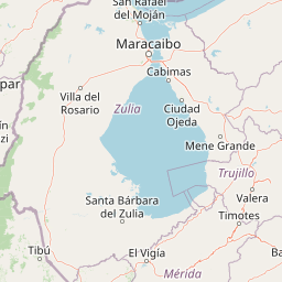
Map view of Dr. José Gregorio Hernández National Park

Use this park location map to pinpoint Dr. José Gregorio Hernández National Park in Venezuela, understand its exact geographic position, and read its mapped placement within the surrounding landscape more clearly.

Pigeon | © OpenStreetMap contributors

Location context for Dr. José Gregorio Hernández National Park

BarinasMéridaTrujillo

Visualizing Andean cloud forests, high-altitude páramo habitats, and rugged mountain terrain

Parque nacional Dr. José Gregorio Hernández Photos and Landscape Scenery

Visual documentation captures the steep ridges, river valleys, and high-mountain ecosystems that define Parque nacional Dr. José Gregorio Hernández. Examining these protected landscapes reveals the remote terrain and cloud forests that shelter vulnerable Andean wildlife.

A mountainous landscape showing the peak of Teta de Niquitao, with golden sunlight hitting the rocky slopes while the lower green slopes remain in shadow.

Park atlas

Compare nearby mountain reserves, wildlife corridors, and connected high-altitude ecosystems

Other Parks Near Parque nacional Dr. José Gregorio Hernández and Surrounding Andean Reserves

Browse protected areas and high-mountain reserves located near Parque nacional Dr. José Gregorio Hernández in the western Andes. Comparing surrounding regional geography helps trace ecological connectivity across neighboring cloud forests and mountain watersheds.
National parkVenezuela
About 15 km away#1 closest

West

Sierra La Culata National Park: Protected Landscape Atlas of the Venezuelan Andes

Explore the páramo ecosystems and mapped terrain of this Venezuelan national park.

Sierra La Culata National Park offers a profound look into the unique geography of the Venezuelan Andes. This protected national park is characterized by its expansive páramo ecosystems, dramatic mountain peaks, and glacial lagoons, creating a distinctive high-altitude wilderness. Use this atlas-focused entry to understand the park's mapped boundaries and its significant role within the region's natural landscape context.

Area
2,004 km²
Established
1989
IUCN
II
Relief
Mountain
Natural monumentTrujillo
About 18 km away#2 closest

North

Monumento Natural Teta de Niquitao-Guirigay: Geography and Protected Area Overview

High-mountain Andean terrain and glacial lake basins in Trujillo.

Monumento Natural Teta de Niquitao-Guirigay serves as a primary example of high-Andean geography, featuring summits exceeding 4,000 meters and unique glacial landforms. The protected area encompasses diverse ecosystems from cloud forest to high-altitude páramo, functioning as a critical sanctuary for regional highland species and a defining landmark within the mountain landscape of Trujillo.

Area
335.36 km²
Established
1996
Relief
Mountain
Climate
Alpine
Watercolor painting showing green hills, a river, and distant mountains under a light sky
National parkVenezuela
About 21 km away#3 closest

Southwest

Sierra Nevada National Park: Venezuela's Majestic Alpine Protected Landscape and Park Boundaries

Explore the highest peaks and glacial terrain of this Venezuelan national park.

Delve into Sierra Nevada National Park, a premier protected area situated in the high Venezuelan Andes. This national park protects a vast expanse of dramatic alpine terrain, including Pico Bolívar and numerous glacial valleys. Understand its mapped boundaries and the unique paramo and cloud forest ecosystems that define this significant natural landscape within Venezuela, offering rich context for atlas-style geographic discovery.

Area
2,764.46 km²
Established
1952
IUCN
II
Relief
Mountain
Watercolor painting of a lake surrounded by soft green hills and coniferous trees with a pale pink sky.
National parkTrujillo
About 38 km away#4 closest

Northeast

Parque nacional Guaramacal: Mapped Protected Landscapes and Andean Mountain Geography

Defining the boundaries and ecological terrain of the Ramal de Guaramacal.

Parque nacional Guaramacal captures a remarkable ecological transition in a compact space, rising from sub-Andean forests to summits above 3,000 meters. This record outlines the park geography, covering the steep ridgelines, glacial lake basins, and the endemic-rich cloud forest zones that define this significant Venezuelan protected area.

Area
215 km²
Established
1988
IUCN
II
Relief
Mountain
National parkVenezuela
About 39 km away#5 closest

Northeast

General Cruz Carrillo en Guaramacal National Park: Venezuela's National Park Landscape

Mapped protected areas and regional geography.

Delve into the protected landscape of General Cruz Carrillo en Guaramacal National Park, a national park situated in Venezuela. This page provides essential geographic context, focusing on the park's mapped boundaries and its role as a protected natural area. Understand its place within the regional geography and discover its unique landscape characteristics, offering a foundation for detailed atlas exploration.

National parkVenezuela
About 59 km away#6 closest

Northeast

Dinira National Park: Protected Watershed and Andean Mountain Landscape

Explore its rugged terrain and páramo ecosystem.

Dinira National Park is a significant protected area in Venezuela, covering rugged Andean terrain vital for watershed protection. This national park features dramatic mountain landscapes, including the Humocaro Mountains and the Los Nepes páramo zone, supporting diverse cloud forest and high-altitude ecosystems. Understanding Dinira National Park offers insight into the geographic context of the Cordillera de Mérida and its hydrological importance.

Area
453.28 km²
Established
1988
IUCN
II
Relief
Mountain
National parkLara State
About 113 km away#7 closest

Northeast

Yacambú National Park National Park: Protected Cloud Forest Landscape in Lara State

Mapped terrain and significant orchid diversity in Venezuela's Andean foothills.

Yacambú National Park is a significant national park in Venezuela's Lara State, protecting crucial humid cloud forest ecosystems in the Andean foothills. The park's terrain is defined by the mountainous topography of the Portuguesa Mountain Range, supporting a rich diversity of flora, including numerous orchid species. Its role in watershed protection for nearby regions underscores its importance as a conserved natural landscape with vital ecological functions.

Area
146 km²
Established
1962
IUCN
II
Relief
Mountain
A soft watercolor painting of a calm lake surrounded by lush green vegetation with distant, hazy mountains under a pale sky.
Natural monumentMérida
About 117 km away#8 closest

Southwest

Laguna de Urao Natural Monument: Geographic Profile and Protected Andean Landscape

Saline tectonic lake located in the Mérida region of Venezuela

Laguna de Urao is a singular protected natural feature of tectonic origin situated in the semi-arid Andean landscape of Mérida. Known for the accumulation of the urao mineral, this saline water body serves as an important geographic landmark that anchors the cultural and geological identity of the local surroundings.

Established
1979
Relief
Upland
Water
Major water bodies

Common questions about visiting, size, designation, and location context for Dr. José Gregorio Hernández National Park

Dr. José Gregorio Hernández National Park FAQs for park facts, access, geography, and protected area context

Find quick answers about Dr. José Gregorio Hernández National Park, including protected-area facts, park geography, trail and visitor context, and how the park fits into its surrounding country and regional landscape.
MoriAtlas Explorer

Continue Your Protected Areas Search Across the Global Atlas

Deepen your exploration by continuing the structured search for national parks and protected areas worldwide. Utilize the comprehensive filtering capabilities to compare different conservation landscapes and refine your understanding of global park geography. Discover more about the distribution and characteristics of protected natural areas.

Global natural geography