

Mori Atlas logo
National parkDthinna Dthinnawan National Park

Discover the mapped boundaries and natural terrain of this Australian national park.

Dthinna Dthinnawan National Park: Australia's Protected Landscape and Geographic Atlas

Dthinna Dthinnawan National Park represents a significant protected area within Australia's vast geography. As a national park, it offers a distinct landscape identity for atlas-driven exploration. This dedicated page provides insight into its mapped boundaries and regional natural context, allowing for a deeper understanding of its place within the Australian protected lands framework.

National ParkNew South WalesBrigalow BeltNandewar BioregionDry Sclerophyll ForestAboriginal Cultural Heritage

Dthinna Dthinnawan National Park

National park

Park overview

Structured park overview, official facts, and landscape profile for Dthinna Dthinnawan National Park

Dthinna Dthinnawan National Park park facts, protected area profile, and essential visitor context

Review the core facts for Dthinna Dthinnawan National Park, including designation, size, terrain, visitor scale, habitats, and operating context in one park-focused overview.

About Dthinna Dthinnawan National Park

Dthinna Dthinnawan National Park protects a culturally and ecologically significant landscape in the northern inland region of New South Wales. Located near the small community of Yetman, the park lies just north of the Bruxner Highway in a region that has experienced substantial agricultural development and vegetation clearing over the past century. The park's establishment on December 1, 2005, marked an important step in preserving the remaining natural values of this part of the Brigalow Belt and Nandewar bioregions, which are recognized for their unique combination of flora and fauna. The landscape features relatively flat to undulating terrain with occasional hills and rocky outcrops where sandstone and granite break through the surface. This varied terrain supports eleven distinct vegetation communities, creating a mosaic of habitats that sustain diverse wildlife populations. The park is also notable for its equestrian trail network, with over 70 kilometers of long-distance and short loop trails available for horse riders, making it a destination of choice for those seeking to explore the Australian bush on horseback.

Quick facts and research context for Dthinna Dthinnawan National Park

Dthinna Dthinnawan National Park was officially reserved on December 1, 2005, making it a relatively recent addition to Australia's protected area network. The park shares a boundary with the adjoining Dthinna Dthinnawan Nature Reserve, together forming a contiguous protected landscape. The area supports eleven distinct vegetation communities, with black cypress, white cypress, and smooth-barked apple serving as the dominant tree species. The park offers over 70 kilometers of equestrian trails, making horse riding a notable recreational activity. The region is home to several threatened species including the black-striped wallaby, zig-zag velvet gecko, squatter pigeon, and delicate mouse.

Protection and recognition

Navigating the official designation history and terrestrial protection scope established in 2005.

Dthinna Dthinnawan National Park Protection Status and Terrestrial Designation

Established in 2005, Dthinna Dthinnawan National Park represents a dedicated terrestrial protected area within the regional conservation framework. Verifying official designation dates and terrestrial status provides essential geographic context for understanding regional conservation boundaries.

Protection details

Protection scope
Terrestrial
Designated year
2005
Transboundary protection
No
Park context

Deeper park guide and search-rich context for Dthinna Dthinnawan National Park

Dthinna Dthinnawan National Park history, landscape, wildlife, and travel context

Explore Dthinna Dthinnawan National Park through its history, landscape character, ecosystems, wildlife, conservation priorities, cultural context, and seasonal travel timing in a structured park guide built for atlas discovery and search intent.

Why Dthinna Dthinnawan National Park stands out

Dthinna Dthinnawan National Park is best known for its cultural significance as a place named in the Gamilaraay language, meaning place for emu footprint, and for protecting important remnant vegetation communities in the Brigalow Belt and Nandewar bioregions of northern New South Wales. The park provides habitat for populations of koalas, squirrel gliders, and glossy black cockatoos, while also supporting several threatened species that inhabit the diverse vegetation communities. The extensive network of horse-riding trails spanning over 70 kilometers makes this park distinctive among New South Wales protected areas, offering recreational access that is less common in many other national parks.

Dthinna Dthinnawan National Park history and protected-area timeline

The history of Dthinna Dthinnawan National Park is deeply intertwined with the cultural heritage of the Gamilaraay people, whose traditional lands this area represents. The parks name, derived from the Aboriginal words dthinna dthinnawan, translates to place for emu footprint, capturing the historical importance of this landscape as a rich source of food and resources. The area provided abundant year-round resources for the Gamilaraay people, supporting their lifestyle and cultural practices over countless generations. On December 1, 2005, both Dthinna Dthinnawan National Park and the adjoining Dthinna Dthinnawan Nature Reserve were officially reserved, formalizing protection for this landscape and its natural and cultural values. This relatively recent establishment places the park among the newer additions to Australias national park system, reflecting continued efforts to identify and protect ecologically significant areas.

Dthinna Dthinnawan National Park landscape and geographic character

The landscape of Dthinna Dthinnawan National Park is characterized by relatively flat to undulating terrain that represents the inland plains of northern New South Wales. Scattered throughout the park are hills and rocky outcrops where sandstone and granite formations emerge from the surrounding terrain, providing visual interest and habitat diversity. These rocky outcrops create microhabitats that support specialized plant and animal species adapted to the rocky environment. The park sits within two recognized bioregions, the southern Brigalow Belt and the Nandewar, each contributing distinctive ecological character to the landscape. The combination of gentle topography with occasional elevated rocky features creates a varied scenery typical of the inland slopes region of New South Wales.

Dthinna Dthinnawan National Park ecosystems, habitats, and plant life

The ecological character of Dthinna Dthinnawan National Park is defined by its eleven identified vegetation communities, which create a diverse habitat mosaic across the protected landscape. The dominant tree species include black cypress, white cypress, and smooth-barked apple, representing the typical dry sclerophyll forest and woodland communities of the region. These vegetation communities provide important habitat for numerous species and represent remnant vegetation in a landscape that has been extensively modified for agriculture. The parks location spanning two bioregions contributes to its ecological diversity, as the Brigalow Belt and Nandewar each support distinct assemblages of plants and animals. Protecting these vegetation communities is significant for maintaining biodiversity in a region where much of the original vegetation has been cleared.

Dthinna Dthinnawan National Park wildlife and species highlights

Dthinna Dthinnawan National Park supports populations of several notable wildlife species, including koalas, squirrel gliders, and glossy black cockatoos. These species represent the parks diverse fauna, from arboreal marsupials to distinctive Australian birds. The park is also home to threatened species that depend on the remaining vegetation and habitat features for their survival. The black-striped wallaby, a vulnerable macropod, has been recorded in the park, alongside the zig-zag velvet gecko, squatter pigeon, and delicate mouse, all of which face conservation pressures in the broader landscape. The presence of these threatened species highlights the importance of the protected area in providing refuge for wildlife in a region where habitat loss has been significant.

Dthinna Dthinnawan National Park conservation status and protection priorities

The establishment of Dthinna Dthinnawan National Park represents an important conservation outcome for the Brigalow Belt and Nandewar bioregions, both of which have experienced considerable vegetation clearing and modification. By protecting remnant vegetation communities and the wildlife they support, the park provides a sanctuary for species including several that are considered threatened. The presence of koalas, squirrel gliders, glossy black cockatoos, and species such as the black-striped wallaby demonstrates the conservation value of this protected area. However, the park faces ongoing challenges from invasive species including feral goats, feral pigs, foxes, cats, wild dogs, and rabbits, as well as invasive weeds such as Coolatai grass, mother-of-millions, prickly pear, and whisky grass, all of which require active management to minimize their impact on natural values.

Dthinna Dthinnawan National Park cultural meaning and human context

The cultural context of Dthinna Dthinnawan National Park is rooted in the traditions of the Gamilaraay people, for whom the area held significant value as a resource-rich location providing year-round food and other necessities. The parks name itself, derived from Aboriginal language and meaning place for emu footprint, reflects this historical relationship between Indigenous people and the landscape. The area would have supported the Gamilaraay with abundant food resources, making it an important site within their traditional Country. This Aboriginal heritage adds cultural depth to the parks significance beyond its ecological values, representing the ongoing connection between Indigenous communities and the Australian landscape.

Top sights and standout views in Dthinna Dthinnawan National Park

Dthinna Dthinnawan National Park offers visitors the opportunity to explore a culturally significant landscape with a name derived from the Gamilaraay language. The parks eleven vegetation communities, dominated by black cypress, white cypress, and smooth-barked apple, support diverse wildlife including koalas, squirrel gliders, and glossy black cockatoos. Over 70 kilometers of horse-riding trails provide a distinctive recreational experience not commonly found in Australias national parks. The combination of cultural heritage, ecological diversity, and recreational opportunities makes this park a notable protected area in northern New South Wales.

Best time to visit Dthinna Dthinnawan National Park

The best time to visit Dthinna Dthinnawan National Park would typically be during the cooler months of autumn and spring when outdoor activities such as horse riding are more comfortable. The inland climate of northern New South Wales can become quite hot during summer, potentially limiting some activities. Winter months may offer mild conditions for exploration, though temperatures can be cool, particularly overnight. Visitors interested in wildlife viewing may find different experiences across seasons, as animal activity patterns change with temperature and food availability.
Monthly climate preview

Long-term temperature ranges and monthly precipitation averages for Australia

Dthinna Dthinnawan National Park Climate Normals and Annual Weather Patterns

Representative coordinate measurements reveal how monthly temperatures shift between cooler winter lows and warmer summer highs alongside varying precipitation levels. Detailed long-term data provides complete annual baseline normals for evaluating regional climate conditions.
Annual mean19 °C
11 °C27 °C
Jan27°
Feb26°
Mar24°
Apr20°
May15°
Jun12°
Jul11°
Aug13°
Sep17°
Oct20°
Nov23°
Dec25°
Warmest month
January

26.9 °C

Coolest month
July

11.1 °C

Wettest month
January

3 mm/day

Driest month
April

0.8 mm/day

Park location guide

Geography guide, regional context, and park location map for Dthinna Dthinnawan National Park

Dthinna Dthinnawan National Park park geography, regions, and map view in Australia

Understand where Dthinna Dthinnawan National Park sits in Australia through a broader geographic reading of the surrounding landscape, nearby location context, and its mapped position within the national park landscape.

How Dthinna Dthinnawan National Park fits into Australia

Australia is a constitutional monarchy and federal parliamentary democracy comprising six states and ten territories. With a population of nearly 28 million, it is one of the world's most urbanised countries, with most people concentrated on the eastern seaboard. The country has a high Human Development Index and is known for its cultural diversity, ancient Aboriginal heritage, and unique wildlife.

Wider geography shaping Dthinna Dthinnawan National Park in Australia

Australia occupies the entire Australian continent, the island of Tasmania, and numerous smaller islands. It is the world's flattest and driest inhabited continent, featuring vast deserts in the interior (the Outback), tropical rainforests along the eastern coast, and a coastline bordering the Indian and Pacific Oceans.

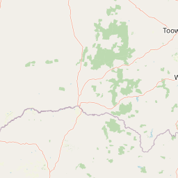
Map view of Dthinna Dthinnawan National Park

Use this park location map to pinpoint Dthinna Dthinnawan National Park in Australia, understand its exact geographic position, and read its mapped placement within the surrounding landscape more clearly.

Pigeon | © OpenStreetMap contributors

Location context for Dthinna Dthinnawan National Park

New South Wales
Park atlas

Compare adjacent protected landscapes, mapped geography, and unique bioregions across northern New South Wales.

Explore National Parks and Protected Areas Near Dthinna Dthinnawan National Park

Continue your park discovery beyond Dthinna Dthinnawan National Park by browsing a curated selection of nearby national parks and other protected areas, exploring similar remnant vegetation, unique topography, and cultural landscapes. This geographic overview helps compare conservation efforts, regional features, and the distinct ecological character of connected protected areas across northern New South Wales.
Watercolor painting of a river flowing between rocky cliffs with forest in the background
National parkNew South Wales
About 33 km away#1 closest

South

Kwiambal National Park: New South Wales National Park with Granite Landscapes and River Confluence

Explore the dramatic scenery of MacIntyre Falls and surrounding protected terrain.

Kwiambal National Park is a significant protected area in New South Wales, Australia, celebrated for its unique granite outcrops and the spectacular confluence of the Severn and Macintyre Rivers at MacIntyre Falls. This national park provides a clear example of regional protected landscape identity, offering valuable context for atlas-driven discovery of Australia's natural geography and mapped terrain. The park's distinctive features contribute to its importance as a conservation reserve within the New England region.

Area
65.17 km²
Established
2000
IUCN
II
Scope
Terrestrial
National parkGoondiwindi Region
About 64 km away#2 closest

Northwest

Bendidee National Park: Protected Landscape and Geographic Context

National park within the Goondiwindi Region, Australia

Bendidee National Park serves as a key protected area in the Goondiwindi Region of Australia. This detail page provides an atlas-focused perspective, detailing the park's mapped geographic extent and its significance as a natural landscape. Gain structured insights into Bendidee National Park's protected status and its place within the broader regional geography for informed exploration.

Area
9.3 km²
Established
1979
IUCN
II
Relief
Lowland
National parkSouthern Downs Region
About 70 km away#3 closest

East

Sundown National Park: National Park with Mapped Protected Boundaries

Southern Downs Region's Protected Landscape Geography

Investigate Sundown National Park, a designated national park in Australia's Southern Downs Region. This resource details its protected landscape identity and geographic setting, offering precise information on its mapped boundaries and regional context for atlas exploration and understanding its conservation value.

Area
160 km²
Established
1977
IUCN
II
Relief
Mountain
National parkQueensland
About 84 km away#4 closest

North

Wondul Range National Park: Queensland Protected Area and Landscape Mapping

Discover the geographic context and mapped boundaries.

Wondul Range National Park offers a unique protected landscape within Queensland, Australia, serving as a key point for geographic and atlas-based exploration. Delve into its specific regional context, understand its mapped park boundaries, and appreciate its role as a designated national park. This entry provides detailed insights into its natural geography and protected-area significance for comprehensive landscape discovery.

Area
35.55 km²
Established
1992
IUCN
II
Scope
Terrestrial
National parkNew South Wales
About 92 km away#5 closest

Southeast

Kings Plains National Park: National Park Protected Area and Geographic Context

Explore mapped boundaries and landscape details for this New South Wales park.

Kings Plains National Park represents a distinct protected area entity within New South Wales, Australia. This national park serves as a focal point for understanding specific geographic features and its mapped boundaries. Users engaging with this park profile can uncover its regional landscape context and explore its significance as part of a larger atlas of protected natural areas. The focus remains on its geographic identity and atlas-based discovery value.

Area
57 km²
Established
1988
IUCN
II
Access
Moderate access
National parkQueensland
About 99 km away#6 closest

East

Girraween National Park: Queensland's Protected National Park Landscape for Atlas Exploration

Mapped geography and protected natural terrain.

Delve into Girraween National Park, a significant protected national park located in Queensland, Australia. This detailed entry provides essential information for understanding its geographic features, mapped boundaries, and the unique natural landscape it preserves. Discover how Girraween National Park fits into the wider Australian atlas and explore its specific regional geography and protected land context.

Area
117 km²
Established
1966
IUCN
II
Relief
Mountain
National parkNew South Wales
About 113 km away#7 closest

East

Bald Rock National Park: Detailed National Park Atlas and Protected Landscape Context

Explore its mapped boundaries and natural terrain within New South Wales.

Bald Rock National Park serves as a key protected area for understanding regional geography and mapped landscapes in New South Wales. This page offers an atlas-centric view of the park, detailing its protected boundaries and providing context for its natural terrain. It is designed for users seeking structured information about national parks and their geographic significance, contributing to a comprehensive understanding of Australia's conservation lands.

Area
88.83 km²
Established
1971
IUCN
II
Relief
Mountain
National parkNew South Wales
About 120 km away#8 closest

East

Maryland National Park: A Detailed Map and Protected Landscape Overview

Explore the geography and mapped boundaries of this national park.

Maryland National Park represents a distinct protected area within New South Wales, Australia, offering rich geographic context for exploration. This page details its role as a national park, focusing on its mapped terrain, landscape character, and position within the regional geography. Users seeking to understand the park's protected boundaries and natural setting will find valuable atlas-style information here, providing a concrete foundation for further geographic study.

Area
9 km²
Established
1999
IUCN
Ia
Relief
Upland

Common questions about visiting, size, designation, and location context for Dthinna Dthinnawan National Park

Dthinna Dthinnawan National Park FAQs for park facts, access, geography, and protected area context

Find quick answers about Dthinna Dthinnawan National Park, including protected-area facts, park geography, trail and visitor context, and how the park fits into its surrounding country and regional landscape.
MoriAtlas Explorer

Continue Your Protected Areas Search Across the Global Atlas

Deepen your exploration by continuing the structured search for national parks and protected areas worldwide. Utilize the comprehensive filtering capabilities to compare different conservation landscapes and refine your understanding of global park geography. Discover more about the distribution and characteristics of protected natural areas.

Global natural geography