
Streams
Park geography
A detailed atlas of the lowland forests, river basins, and mapped natural landscapes
Geographic Profile of Forêts National Park: Administrative Regions, Land Area, and Terrain
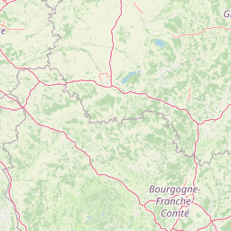
This geographic profile covers the 560 square kilometer expanse of Forêts National Park, spanning the Haute-Marne and Côte-d'Or regions of France. Explore mapped natural features including river systems like the Aube and Aujon, along with distinct forest, woodland, and grassland habitats across the lowland terrain.
France's broadleaf forest conservation flagship in the Paris Basin
Forêts National Park
Forêts National Park is France's newest national park, established in 2019 in the northeastern part of metropolitan France spanning the departments of Haute-Marne and Côte-d'Or. As the country's eleventh national park and second largest, it occupies a distinctive position as the sole national park in both the Grand Est and Bourgogne-Franche-Comté regions. The park protects the extensive broad-leaved forests characteristic of the southeastern Paris Basin plateau, representing France's first national park specifically dedicated to the conservation of lowland deciduous forests and their associated ecosystems. The protected area encompasses approximately 560 square kilometres of predominantly public forestland, with a core zone covering around 56,614 hectares that is 95 percent forested.
- Location
- France
- Park type
- National park
- Established
- 2019
- Area
- 560 km²
Location overview
Regional placement within Haute-Marne and Côte-d'Or in France
Geographic Location and Regional Setting of Forêts National Park
Forêts National Park lies within the European nation of France, spanning the departments of Haute-Marne and Côte-d'Or. As a terrestrial, inland protected area, its administrative footprint remains entirely non-transboundary.
- Countries
- France
- Regions
- Côte-d'Or, Haute-Marne
- Primary location
- France
- Geographic setting
- Inland
Boundary and coordinates
Charting the spatial coordinates and 560 square kilometer regional spread
Mapped Boundaries and Geographic Extent of Forêts National Park
Mapped boundary geometry outlines the physical footprint and regional layout of Forêts National Park. Calculated data details the 560 square kilometer area alongside estimated perimeter, center, and coordinate span limits.
- Boundary area
- 566.9 km²
- Boundary perimeter
- 770.4 km
- Northernmost point
- 48.0443° N
- Southernmost point
- 47.6826° N
- Easternmost point
- 5.1965° E
- Westernmost point
- 4.5559° E
- Geographic centre
- 47.8442° N, 4.9167° E
- North–south span
- 40.2 km
- East–west span
- 47.9 km
Terrain and natural features
Stored lowland terrain classifications and internal hydrological features
Forêts National Park Terrain and Named Natural Features
Recorded lowland relief classifications define the primary landscape structure within Forêts National Park. Associated feature cards catalog internal streams, rivers, springs, wetlands, and valleys.
Selected named natural features
Streams
La Digeanne
Wetlands
Marais des Brosses
Rivers
Torrent de Bougeon
Streams
Le Coupe-Charme
Streams
L'Aujon
Environmental setting
Temperate lowland forest ecosystems, woodlands, and regional habitat types
Environmental Classifications and Physical Setting of Forêts National Park
Recorded landscape features, habitat types, and climate zones offer complementary ways to read the physical setting of Forêts National Park. Stored categories connect directly to relevant atlas destinations and broader regional classifications.
- Relief
- Lowland
- Climate
- Temperate
- Water
- Minor water
- Forest cover
- Mostly forested
Landscape features
Forest · Woodland · Grassland
Habitat types
Temperate broadleaf forest · Grassland
Park atlas
Explore the regional spread of protected landscapes across the Paris Basin plateau and beyond
Discover More Protected Areas and National Parks Near Forêts National Park
After exploring Forêts National Park, continue your geographic discovery by browsing other protected areas and national parks in the surrounding region. Trace the distribution of lowland deciduous forests, wetlands, and unique limestone grasslands across related conservation landscapes.
Nature reserveGrand Est
About 4.3 km away#1 closest
Southeast

Réserve naturelle régionale des pelouses et bois de Villemoron: Protected Area and Map
Regional nature reserve in the Grand Est, France
This protected area provides a rare glimpse into the limestone-based geography of the Haute-Marne department. Featuring a structured mix of oak forests and open calcareous grasslands, the reserve serves as an essential habitat refuge within the larger landscape of the Grand Est region. Use our mapped data to trace the boundaries and features of this uniquely managed natural environment.
- Area
- 0.87 km²
- Established
- 2015
- IUCN
- IV
- Relief
- Upland
Nature reserveHaute-Marne
10 km away#2 closest
Tufière de Rolampont Nature Reserve: Travertine Cascades and Geological Heritage in Haute-Marne
A rare living limestone formation in the Grand Est region of France
Tufière de Rolampont offers a window into the evolution of calcareous wetland ecosystems within the Champagne plateau. Visitors observe a process of natural stone creation where mineral-rich water encrusts living mosses, resulting in the stepped terraces that define this protected landscape. This site serves as a vital laboratory for understanding the intersection of hydrological heritage and unique botanical habitats.
- Area
- 0.126 km²
- Established
- 1982
- Relief
- Lowland
- Climate
- Temperate
Nature reserveBourgogne-Franche-Comté
About 25 km away#3 closest
South
Réserve naturelle régionale du Peuptu de la Combe Chaignay: Regional Nature Reserve Profile
Protected calcareous habitats in the Burgundy limestone uplands.
Spanning 36.6 hectares in the Côte-d'Or, this reserve protects a characteristic combe landform carved into Jurassic limestone plateaus. It serves as a vital example of site-specific conservation within the Bourgogne-Franche-Comté region, focusing on the management of habitats essential to the northern French countryside.
- Area
- 0.366 km²
- Established
- 2025
- IUCN
- IV
- Relief
- Mixed relief
Nature reserveBourgogne-Franche-Comté
About 29 km away#4 closest
South
Réserve naturelle régionale du Val-Suzon: Protected Landscape and Geographic Atlas
Wooded limestone valleys in the Bourgogne-Franche-Comté region
Spanning the meandering Suzon river, this large regional nature reserve provides a essential look at the limestone plateaus and deciduous woodlands of Côte-d'Or. The area serves as a primary reference for regional biodiversity, containing dry grasslands, rocky slopes, and sensitive tufa springs protected within its defined borders. This resource outlines the physical terrain and conservation significance of the territory for those mapping the natural landscape of eastern France.
- Area
- 29.806 km²
- Established
- 2011
- Relief
- Upland
- Climate
- Temperate
Nature reserveGrand Est
About 32 km away#5 closest
North
Réserve naturelle régionale de la pelouse de la côte de l'étang: Regional Nature Reserve Geography
Calcareous grassland protected area in the Grand Est region of France
Discover the geographic character of Réserve naturelle régionale de la pelouse de la côte de l'étang. This reserve showcases a specialized dry grassland landscape on a sun-drenched slope, providing a critical haven for rare flora and fauna in the heart of the Barrois champenois territory.
- Area
- 0.108 km²
- Established
- 2010
- IUCN
- IV
- Relief
- Upland
Nature reserveBourgogne-Franche-Comté
About 39 km away#6 closest
South
Réserve naturelle régionale de la grotte du Contard: Protected Karst and Cave Geography
Regional natural reserve in the Bourgogne-Franche-Comté landscape
Located near Dijon, the Réserve naturelle régionale de la grotte du Contard is a protected area focused on preserving the karst features and geological heritage of the Côte-d'Or. This site serves as a vital example of subterranean habitat conservation, showcasing the unique interaction between water-sculpted limestone cavities and the surrounding plateau terrain. Explore the geographic extent of this reserve and understand its role within the regional natural reserve network.
- Area
- 0.259 km²
- Established
- 2025
- IUCN
- IV
- Climate
- Temperate
Nature reserveGrand Est
About 41 km away#7 closest
North
Réserve naturelle régionale de l'étang de Ramerupt: Geography and Protected Wetland Atlas
Mapping the historic Champagne humide pond landscape in Grand Est
Examine the dense wetland mosaic of Réserve naturelle régionale de l'étang de Ramerupt, a 33-hectare sanctuary in the Aube department. This resource traces the pond edges, reedbed structures, and wet woodland terrain that comprise this essential regional nature reserve, highlighting the intersection of human water management and natural marshland succession in the French countryside.
- Area
- 0.336 km²
- Established
- 2010
- IUCN
- IV
- Relief
- Lowland
Nature reserveGrand Est
About 51 km away#8 closest
Northwest
Réserve naturelle nationale de la forêt d'Orient: Protected Landscapes and Wetland Mapping
Key protected area in the Grand Est region of France
Investigate the geographic structure of Réserve naturelle nationale de la forêt d'Orient, a reserve shaped by reservoir-driven water cycles. This protected area features a diverse arrangement of lake-edge mudflats, expansive reedbeds, and temperate forest cover. Gain insight into the regional importance of these habitats as a node for migratory bird pathways and native terrestrial biodiversity in eastern France.
- Area
- 15.6 km²
- Established
- 2002
- IUCN
- IV
- Relief
- Lowland
MoriAtlas Explorer
Continue Exploring Forêts National Park's Protected Landscape and Geography
Deepen your understanding of Forêts National Park's protected status and its significance within the French atlas. This destination offers a structured look at mapped park boundaries, unique lowland forest ecosystems, and the regional geography that defines this important natural landscape. Continue your discovery of France's protected areas by examining its specific geographic attributes and conservation value.
Browse next
Global natural geography
Explore related park routes
Explore MoriAtlas Global ParksBrowse All MoriAtlas ParksGlobal Park Map DiscoveryMoriAtlas: Browse All CountriesBrowse All MoriAtlas ContinentsNational Park Environment AtlasGrand Canyon National Park AtlasYellowstone National Park AtlasYosemite National Park Atlas and GeographySerengeti National Park AtlasGalápagos National Park Protected LandscapeBanff National Park Geography and AtlasKruger National Park Atlas EntryUluṟu-Kata Tjuṯa National Park AtlasExplore Uluru-Kata Tjuta National Park GeographyPlitvice Lakes National Park AtlasFiordland National Park Protected LandscapeGreat Smoky Mountains National Park AtlasAfghanistan National Parks and Protected AreasAlbania National Parks and Protected AreasAlgeria National Parks and Protected AreasAmerican Samoa National Parks and Protected AreasAndorra National Parks and Protected AreasAngola National Parks and Protected AreasAntarctica National Parks and Protected AreasAntigua and Barbuda Park List