Mori Atlas logo
Nature reserveGara-Gel State Reserve

Analyzing the protected high-altitude landscape and transitional ecological zones of the Karabakh plateau.

Gara-Gel State Reserve: An Atlas Exploration of a Volcanic Crater Lake and Mountain Terrain

Gara-Gel State Reserve occupies a specialized niche within the Karabakh volcanic plateau of Azerbaijan, protecting a rare glacial-origin lake situated directly inside an extinct volcanic crater. Spanning 240 hectares, the reserve serves as a critical junction for transitional flora between Caucasian and Armenian-Iranian botanical provinces. This high-altitude basin provides an essential look at mountain meadow ecosystems and regional hydrological features, while the surrounding peaks create a distinct bowl-shaped profile that remains a vital focal point for geological and botanical study in the South Caucasus.

volcanic lakehigh-altitude reserveKarabakh plateauglacial originmountain meadowsAzerbaijan

Gara-Gel State Reserve

Nature reserve

Park overview

Structured park overview, official facts, and landscape profile for Gara-Gel State Reserve

Gara-Gel State Reserve park facts, protected area profile, and essential visitor context

Review the core facts for Gara-Gel State Reserve, including designation, size, terrain, visitor scale, habitats, and operating context in one park-focused overview.

About Gara-Gel State Reserve

Gara-Gel State Reserve is a compact but ecologically focused protected area in the southern part of the Karabakh volcanic plateau in Azerbaijan. Established in 1987, it covers an area of around 240 hectares and is dedicated to preserving the rare ecological system associated with the lake at its center and the natural complexes of the land that surrounds it.

The defining feature of the reserve is Lake Ishigli-Gara-Gel, a relict body of water that fills the crater of an extinct volcano. The lake has a glacial origin in addition to its volcanic setting, and it lies at a high elevation of approximately 2,658 meters above sea level. Its basin is roughly 1,950 meters long and 1,250 meters wide at its broadest point, with a coastline extending around 5,500 meters and a maximum depth close to 8 meters.

The surrounding terrain shapes both the hydrology and ecology of the reserve. Foothills and mountains rising between roughly 3,200 and 3,500 meters frame the lake, and the basin is fed mainly by rainfall and snowmelt, supplemented to a limited extent by spring water. This high-altitude setting, combined with the plateau's position between the Caucasian and Armenian-Iranian floristic provinces, gives the area a transitional botanical character that distinguishes it from neighboring regions.

Administratively, Gara-Gel is recognized as an inter-republic reserve, reflecting its broader regional ecological importance. In recent decades, the reserve has fallen under Armenian control and is presently not operating as an active protected site, although its ecological profile and surrounding flora continue to make it a noteworthy natural landmark of the Karabakh highlands.

Quick facts and research context for Gara-Gel State Reserve

Gara-Gel State Reserve was established in 1987 and covers approximately 240 hectares on the southern Karabakh volcanic plateau. Its core feature is Ishigli-Gara-Gel, a relict lake of glacial and volcanic origin lying at about 2,658 meters above sea level.

The reserve is classified as an inter-republic reserve and was created specifically to protect a rare high-altitude lacustrine ecosystem and its surrounding natural complexes. The lake fills a volcanic crater and is fed by precipitation, snowmelt, and limited spring water, giving it a hydrology shaped by the surrounding mountain climate.

Protection and recognition

Review documented terrestrial protection scope and baseline conservation parameters

Gara-Gel State Reserve Protection Status and Territorial Designation Facts

Gara-Gel State Reserve maintains a defined terrestrial protection scope within its designated conservation boundaries. Structured parameters outline the documented management framework and established administrative status for this protected landscape.

Protection details

Protection scope
Terrestrial
Transboundary protection
No
Park context

Deeper park guide and search-rich context for Gara-Gel State Reserve

Gara-Gel State Reserve history, landscape, wildlife, and travel context

Explore Gara-Gel State Reserve through its history, landscape character, ecosystems, wildlife, conservation priorities, cultural context, and seasonal travel timing in a structured park guide built for atlas discovery and search intent.

Why Gara-Gel State Reserve stands out

Gara-Gel is best known for protecting a high-altitude lake formed inside the crater of an extinct volcano on the Karabakh plateau. The reserve's combination of glacial origin, volcanic setting, and ecologically transitional mountain flora gives it a distinctive character among Azerbaijan's protected natural areas. The lake also stands out as a habitat where a Red-Book-listed Sevan trout variant was introduced in the 1960s, adding aquatic biological significance to an otherwise high-mountain botanical reserve. Its lakeside meadows, dominated by clover and tragacanth species, reflect the dry, sunny conditions of the surrounding plateau.

Gara-Gel State Reserve history and protected-area timeline

Gara-Gel State Reserve was formally established in 1987 as a protected area within the Azerbaijani system of state reserves. Its creation was motivated by the need to protect the rare ecological system associated with Lake Ishigli-Gara-Gel and the natural complexes that surround the water basin on the southern Karabakh volcanic plateau.

Prior to its designation as a reserve, the lake had already attracted scientific attention for its glacial and volcanic origins and for its unusual ecological setting at more than 2,600 meters above sea level. In 1967, a variety of Sevan trout listed in the Red Book was introduced into the lake, foreshadowing the conservation interest that would later lead to formal protection.

The reserve was classified as an inter-republic reserve, indicating that its ecological significance extended beyond the borders of a single administrative region. More recently, the area has come under the control of Armenian forces, and the reserve is currently not operating as an active management site.

Gara-Gel State Reserve landscape and geographic character

The landscape of Gara-Gel State Reserve is dominated by the Karabakh volcanic plateau and the high-mountain basin that cradles Lake Ishigli-Gara-Gel. The lake lies at approximately 2,658 meters above sea level, occupying the crater of an extinct volcano and giving the area a distinctly bowl-shaped profile framed by rising slopes and ridges.

Beyond the immediate lakeshore, the surrounding terrain climbs into foothills and mountains that reach between roughly 3,200 and 3,500 meters in elevation. These higher slopes define the visual character of the reserve and influence its climate, drainage, and vegetation, creating a sharp transition from the lakeside meadows to the alpine zones above.

The lake itself has a coastline of about 5,500 meters and a maximum depth near 8 meters, with a relatively shallow basin fed mainly by rain and snowmelt rather than by major rivers. The combination of volcanic origin, glacial history, and high plateau setting produces a landscape that feels both open and enclosed, with the water body serving as the focal point of an otherwise rugged highland terrain.

Gara-Gel State Reserve ecosystems, habitats, and plant life

Ecologically, Gara-Gel occupies a transitional zone between the Caucasian and Armenian-Iranian botanical and geographic provinces, which gives its flora a mixed and regionally distinctive composition. The reserve's vascular plant checklist includes around 102 species and subspecies distributed across roughly 68 genera and 27 families.

Plant diversity within the strict reserve boundary is relatively modest because the protected area centers on the lake itself, while many rare and endemic species occur just outside the reserve but close to its borders. Along the lakeshore, vegetation is characterized by meadows dominated by Trifolium, along with tragacanth-forming Astragalus and Tragacantha species adapted to the dry, sun-exposed conditions of the plateau.

Swamp and aquatic flora are limited by the reserve's high elevation. Only two plant species are recorded within the lake water itself, Polygonum amphibium and a Ranunculus species, reflecting the cold, shallow, and largely meltwater-fed nature of the basin.

Gara-Gel State Reserve wildlife and species highlights

The wildlife profile of Gara-Gel State Reserve is closely tied to its high-altitude lake ecosystem. The lake is the most significant faunal feature of the protected area, particularly after the 1967 introduction of a Sevan trout variant that is included in the Red Book.

This fish introduction remains one of the reserve's most distinctive biological events, giving the waters an ecological role beyond their scenic and hydrological value. The surrounding mountain and meadow habitats also support broader regional fauna typical of the Karabakh plateau, although the formal reserve area has a relatively short species inventory because of its small size and focus on the lake basin.

Gara-Gel State Reserve conservation status and protection priorities

Gara-Gel State Reserve was created specifically to protect a rare high-altitude lacustrine ecological system and the natural complexes surrounding it. Its designation reflects the scientific recognition that the lake, despite its small size, holds an unusual combination of glacial origin, volcanic crater setting, and transitional mountain flora.

The reserve's status as an inter-republic reserve highlights its broader regional conservation importance, extending its significance beyond purely local protection. The presence of a Red-Book-listed trout lineage in the lake further strengthens its conservation profile, giving the site value for both aquatic and terrestrial biodiversity.

However, ongoing political circumstances have left the reserve under external control and not currently operating as an active protected area, raising concerns about the long-term management of its ecological assets.

Top sights and standout views in Gara-Gel State Reserve

Gara-Gel's most striking feature is a relict lake of glacial and volcanic origin sitting at nearly 2,700 meters above sea level on the Karabakh plateau. The reserve protects not only the lake but also the meadows, foothills, and higher slopes that together form a rare high-mountain ecological system.

Its transitional position between Caucasian and Armenian-Iranian floristic provinces gives it a botanical identity unlike most other lowland Azerbaijani reserves, while the 1967 introduction of a Red-Book Sevan trout adds a rare aquatic conservation dimension. The compact 240-hectare footprint also means the reserve is unusually focused, built around a single volcanic crater lake rather than a broader landscape mosaic.

Best time to visit Gara-Gel State Reserve

Because Gara-Gel is a high-elevation reserve centered on a meltwater-fed lake, the warmer months of late spring through early autumn are generally the most practical period for considering a visit, when snow has receded from the lower slopes and access to the plateau is more feasible. In winter and early spring, heavy snow accumulations at elevations above 2,600 meters would make the terrain significantly more difficult to reach and would also limit the visibility of the lake's ecological features.

Summer conditions bring out the meadows of Trifolium, Astragalus, and Tragacantha along the lakeshore, making this a particularly appealing season for observing the distinctive high-altitude flora of the Karabakh plateau. Visitors generally interested in the broader landscape and botanical character of the site will find the warmer half of the year more rewarding, although specific access arrangements are currently affected by the reserve's status.

Monthly climate preview

Long-term temperature ranges and monthly precipitation data for Azerbaijan

Gara-Gel State Reserve Climate Normals and Annual Weather Patterns

Historical climate records outline the measured annual temperature progression and daily precipitation rates across twelve months at Gara-Gel State Reserve. Reviewing the comprehensive monthly profile provides deeper analytical context for long-term meteorological trends at this protected elevation.
Annual mean6 °C
-5 °C18 °C
Jan-5°
Feb-4°
Mar
Apr
May11°
Jun15°
Jul18°
Aug18°
Sep14°
Oct
Nov
Dec-3°
Warmest month
August

17.8 °C

Coolest month
January

-5.3 °C

Wettest month
May

1.2 mm/day

Driest month
August

0.4 mm/day

Park location guide

Geography guide, regional context, and park location map for Gara-Gel State Reserve

Gara-Gel State Reserve park geography, regions, and map view in Azerbaijan

Understand where Gara-Gel State Reserve sits in Azerbaijan through a broader geographic reading of the surrounding landscape, nearby location context, and its mapped position within the national park landscape.

How Gara-Gel State Reserve fits into Azerbaijan

Azerbaijan is a unitary semi-presidential republic and one of six independent Turkic states. It declared independence from the Soviet Union in 1991 after nearly seven decades of Soviet rule. The country occupies 86,600 km² and has a population of approximately 10.3 million. It is known for its strategic location at the crossroads of Europe and Asia, its oil industry heritage, and its diverse cultural influences from Persian, Russian, and Turkic traditions.

Wider geography shaping Gara-Gel State Reserve in Azerbaijan

Azerbaijan occupies the eastern portion of the Caucasus region, situated between the Caspian Sea to the east and the Greater Caucasus mountains to the north. The terrain is diverse, featuring lowlands along the Caspian coast, mountainous areas in the north and west, and semi-desert plains in the central regions. The Kura and Aras rivers are major waterways draining into the Caspian Sea.

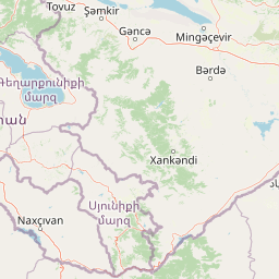
Map view of Gara-Gel State Reserve

Use this park location map to pinpoint Gara-Gel State Reserve in Azerbaijan, understand its exact geographic position, and read its mapped placement within the surrounding landscape more clearly.

Pigeon | © OpenStreetMap contributors
Park atlas

Explore regional protected landscapes and highland nature reserves connected to the Karabakh plateau.

Parks Near Gara-Gel State Reserve: Compare Surrounding Highlands and Protected Areas

Compare Gara-Gel State Reserve with other protected areas across the surrounding highland terrain. Broaden your geographic perspective by examining adjacent mountain ecosystems and regional park geography.
National parkGegharkunik Province
About 56 km away#1 closest

Northwest

Sevan National Park: High-Altitude Lake and Protected Landscape in Gegharkunik

Explore map context, park boundaries, and regional geography.

Sevan National Park is a vital protected area located in Armenia's Gegharkunik Province, primarily safeguarding the remarkable high-altitude Lake Sevan. Established to protect this significant freshwater ecosystem, the park encompasses diverse surrounding landscapes including wetlands, forests, and steppes. Users exploring this canonical park detail page can delve into its geographic setting within the Armenian highlands, understand its importance as a protected landscape, and access structured data relevant to its unique natural environment. This MoriAtlas entry offers a focused lens on the park's conservation status and its contribution to regional geography.

Area
342 km²
Established
1978
IUCN
II
Relief
Highland
Watercolor illustration of a mountainous landscape with green fields, a river, and a sunset sky
National parkOrdubad District
About 69 km away#2 closest

South

Zangezur National Park: National Park and Protected Mountain Wilderness in Ordubad District

Explore dramatic glacial terrain and the highest Lesser Caucasus peaks.

Zangezur National Park encompasses a significant portion of the Zangezur mountain range, presenting a striking high-altitude protected landscape within Ordubad District, Azerbaijan. Its geography is characterized by rugged alpine features, extensive glacial formations, and dramatic elevation changes culminating in the Gemiqaya summit. This park serves as a vital refuge for diverse ecosystems and is distinguished by its role in preserving the highest mountain terrain in Azerbaijan's Lesser Caucasus, offering a unique focal point for geographic and protected-area exploration.

Area
427.97 km²
Established
2003
IUCN
II
Relief
Mountain
Watercolor illustration of a lake surrounded by greenery with mountains in the background
National parkAzerbaijan
About 74 km away#3 closest

North

Göygöl National Park: Iconic Alpine Lakes and Protected Caucasus Forest Landscape

Explore Azerbaijan's most visited national park and its rich geographic context.

Göygöl National Park is a key protected area in Azerbaijan, renowned for the crystal-clear alpine Lake Göygöl and its surrounding dense forests within the Lesser Caucasus mountains. This national park showcases over 420 plant species, significant wildlife populations, and dramatic mountainous terrain, making it a prime destination for understanding regional landscape diversity and protected land value. Use MoriAtlas to explore its mapped boundaries and connect it to the broader geographic context of Azerbaijan.

Area
127.55 km²
Established
2008
IUCN
II
Relief
Mountain
A horizontal watercolor painting depicting rolling green hills, distant mountains, and sparse vegetation.
Nature reserveArarat Province
About 86 km away#4 closest

West

Khosrov Forest State Reserve: Mapping Armenia's Historic Nature Reserve and Mountain Geography

Explore ancient juniper forests and rugged canyon terrain in Ararat Province.

Khosrov Forest State Reserve is a critical protected landscape in Armenia defined by its remarkable elevational gradient. From semi-desert lowlands to high mountain meadows, the reserve encompasses unique Tertiary relict forests and river-cut gorges. This resource maps the park's boundaries and provides a clear geographic overview of its diverse ecosystems and cultural heritage within the Ararat Province.

Area
232.13 km²
Established
1958
IUCN
Ia
Relief
Mountain
Nature reserveSyunik Province
About 91 km away#5 closest

Southeast

Shikahogh State Reserve: Geographic Mapping and Protected Forest Territory Analysis

Exploring the mountain terrain and biodiversity of Syunik Province

Shikahogh State Reserve serves as a strictly protected forest sanctuary in southern Armenia, characterized by its complex vertical relief and transition between Caucasian forest and arid landscape elements. The reserve spans the upper basins of the Tsav and Shikahogh rivers, featuring a dense canopy and unique habitat for varied mountain fauna. This geographic overview highlights the reserve as a central feature of the Zangezur mountain ecology.

Area
103.3 km²
Established
1958
IUCN
Ia
Relief
Mountain
Watercolor illustration showing mountains, green forests, and a winding river under a soft pink sky.
National parkSyunik Province
About 92 km away#6 closest

South

Arevik National Park: Syunik Province's Protected Mountain Landscape and Biodiversity Atlas

Explore mapped boundaries, terrain, and ecosystems.

Arevik National Park offers a detailed look into the geography and protected landscape of Armenia's Syunik Province. This park is defined by the rugged Zangezur mountains and its remarkable vertical ecological zoning, transitioning from semi-desert to alpine environments. Examine its mapped terrain, significant butterfly and bird habitats, and the presence of key mammal species, providing a comprehensive atlas-style understanding of this protected area's natural identity.

Area
344 km²
Established
2009
IUCN
II
Relief
Mountain
Nature reserveZangilan District
About 97 km away#7 closest

Southeast

Basut-Chay State Reserve: Regional Geography and Protected Forest Landscape Atlas

Nature reserve in the Lesser Caucasus of Azerbaijan

Basut-Chay State Reserve protects a significant riverine landscape dominated by centuries-old Oriental plane trees. Located within the Zangilan District, the area showcases a compact ecological gradient featuring alluvial river terraces and steep mountain slopes. This strict nature reserve provides a essential reference for studying Caucasian floodplain forest remnants and mountain valley topography.

Area
1.07 km²
Established
1974
IUCN
Ia
Relief
Mountain
A horizontal watercolor illustration depicting rolling, sandy desert dunes in the foreground and light purple, hazy mountain silhouettes in the background against a white sky.
Wildlife reserveArarat Province
About 111 km away#8 closest

West

Goravan Sands Sanctuary: Protected Sandy Semi-Desert Ecosystems in Ararat Province

A rare relict landscape of Armenia's Caucasus biodiversity

Goravan Sands Sanctuary preserves a striking mosaic of sandy plains, dry limestone ridges, and tertiary clay habitats within the Ararat Province. Known for hosting the only known Armenian population of the relict phog shrub, this reserve is a reference site for psammophilic flora and endemic invertebrate fauna. Explore the layered geography and arid biodiversity of this high-priority South Caucasus conservation landscape.

Area
0.96 km²
Established
1959
Relief
Upland
Climate
Arid

Common questions about visiting, size, designation, and location context for Gara-Gel State Reserve

Gara-Gel State Reserve FAQs for park facts, access, geography, and protected area context

Find quick answers about Gara-Gel State Reserve, including protected-area facts, park geography, trail and visitor context, and how the park fits into its surrounding country and regional landscape.
MoriAtlas Explorer

Continue Your Protected Areas Search Across the Global Atlas

Deepen your exploration by continuing the structured search for national parks and protected areas worldwide. Utilize the comprehensive filtering capabilities to compare different conservation landscapes and refine your understanding of global park geography. Discover more about the distribution and characteristics of protected natural areas.

Global natural geography