
Mori Atlas logo
National parkGeneral Cruz Carrillo en Guaramacal National Park

Discover the mapped boundaries and geographic context of this Venezuelan national park.

General Cruz Carrillo en Guaramacal National Park: Venezuela's Protected Natural Landscape

General Cruz Carrillo en Guaramacal National Park stands as a significant protected area within Venezuela, representing a vital component of the country's natural landscape. As a national park, it offers users a focal point for understanding regional geography and mapped terrain. This entry provides the core identity and geographic anchoring for exploring the park's protected boundaries and its place within Venezuela's broader natural context, serving as an essential gateway for atlas-driven discovery.

protected areasVenezuelanational parksAndes region

General Cruz Carrillo en Guaramacal National Park

National park

Park overview

Structured park overview, official facts, and landscape profile for General Cruz Carrillo en Guaramacal National Park

General Cruz Carrillo en Guaramacal National Park park facts, protected area profile, and essential visitor context
Review the core facts for General Cruz Carrillo en Guaramacal National Park, including designation, size, terrain, visitor scale, habitats, and operating context in one park-focused overview.
Park location guide

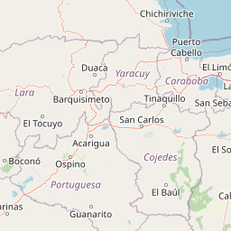
Geography guide, regional context, and park location map for General Cruz Carrillo en Guaramacal National Park

General Cruz Carrillo en Guaramacal National Park park geography, regions, and map view in Venezuela
Understand where General Cruz Carrillo en Guaramacal National Park sits in Venezuela through a broader geographic reading of the surrounding landscape, nearby location context, and its mapped position within the national park landscape.

How General Cruz Carrillo en Guaramacal National Park fits into Venezuela

Venezuela is a country in northern South America with coastline along the Caribbean Sea and Atlantic Ocean. It borders Colombia, Brazil, Guyana, and Trinidad and Tobago. The country has an area of approximately 916,445 km² and a population of about 31.8 million. Caracas is the capital and largest city. Venezuela consists of 23 states and the Capital District.

Wider geography shaping General Cruz Carrillo en Guaramacal National Park in Venezuela

Venezuela is located on the northern coast of South America. The continental territory is bordered by the Caribbean Sea and Atlantic Ocean to the north, Colombia to the west, Brazil to the south, and Guyana to the east. Trinidad and Tobago lies to the northeast. The country includes various islands and islets in the Caribbean Sea known as the Federal Dependencies.

Common questions about visiting, size, designation, and location context for General Cruz Carrillo en Guaramacal National Park

General Cruz Carrillo en Guaramacal National Park FAQs for park facts, access, geography, and protected area context
Find quick answers about General Cruz Carrillo en Guaramacal National Park, including protected-area facts, park geography, trail and visitor context, and how the park fits into its surrounding country and regional landscape.
MoriAtlas Explorer

Continue Your Protected Areas Search Across the Global Atlas

Deepen your exploration by continuing the structured search for national parks and protected areas worldwide. Utilize the comprehensive filtering capabilities to compare different conservation landscapes and refine your understanding of global park geography. Discover more about the distribution and characteristics of protected natural areas.

Global natural geography