Mori Atlas logo
Protected areaHațeg Country Dinosaur Geopark

Navigate the mapped boundaries and regional context of this distinct protected area in Romania.

Hațeg Country Dinosaur Geopark: Exploring Romania's Protected Landscape and Geographic Identity

(Hațeg Country Dinosaurs Geopark)

The Hațeg Country Dinosaur Geopark stands as a key protected area within Romania, offering a unique lens through which to explore the country's complex geography. This page serves as your entry point to understanding the park's mapped boundaries and its place within the broader regional landscape of Southeastern Europe. Delve into the geographic context and protected landscape features that define this significant natural entity.

UNESCO Global GeoparkPaleontological SiteCretaceous FossilsDinosaur DiscoveriesRomaniaTransylvania
Illustration showing a wooden boardwalk path through a meadow with birch trees and yellow flowers leading to a waterfall in a mountainous landscape with a setting sun

Hațeg Country Dinosaur Geopark

Protected area

Park overview

Structured park overview, official facts, and landscape profile for Hațeg Country Dinosaur Geopark

Hațeg Country Dinosaur Geopark park facts, protected area profile, and essential visitor context
Review the core facts for Hațeg Country Dinosaur Geopark, including designation, size, terrain, visitor scale, habitats, and operating context in one park-focused overview.

About Hațeg Country Dinosaur Geopark

Hațeg Country Dinosaur Geopark represents a distinctive type of protected area that combines geological preservation with paleontological significance. Located in the Hațeg Depression of Romania's Hunedoara County, the geopark protects an area where scientific excavations have uncovered remarkable dinosaur fossils over more than a century of research. The geological formations exposed in the region tell a story of an ancient archipelago that existed on the Tethys Ocean margin during the Late Cretaceous period, when what is now Romania was part of a chain of islands in a shallow sea. The fossil discoveries from Hațeg have included multiple species new to science, many of which display evolutionary characteristics distinct from dinosaur faunas found elsewhere in Europe or globally. This scientific legacy, combined with the area's cultural heritage of traditional villages and historic towns, creates a geopark of considerable depth and interest.

Quick facts and research context for Hațeg Country Dinosaur Geopark

Hațeg Country Dinosaur Geopark is situated in the Hațeg Depression of central Romania, an area renowned for its extraordinary Cretaceous dinosaur fossils. The geopark covers a territory characterized by sedimentary geological formations that have yielded multiple significant dinosaur discoveries, including species unique to this region. The area represents one of the most important dinosaur fossil sites in Europe and serves as a living laboratory for paleontological research and geological study.

Park context

Deeper park guide and search-rich context for Hațeg Country Dinosaur Geopark

Hațeg Country Dinosaur Geopark history, landscape, wildlife, and travel context
Explore Hațeg Country Dinosaur Geopark through its history, landscape character, ecosystems, wildlife, conservation priorities, cultural context, and seasonal travel timing in a structured park guide built for atlas discovery and search intent.

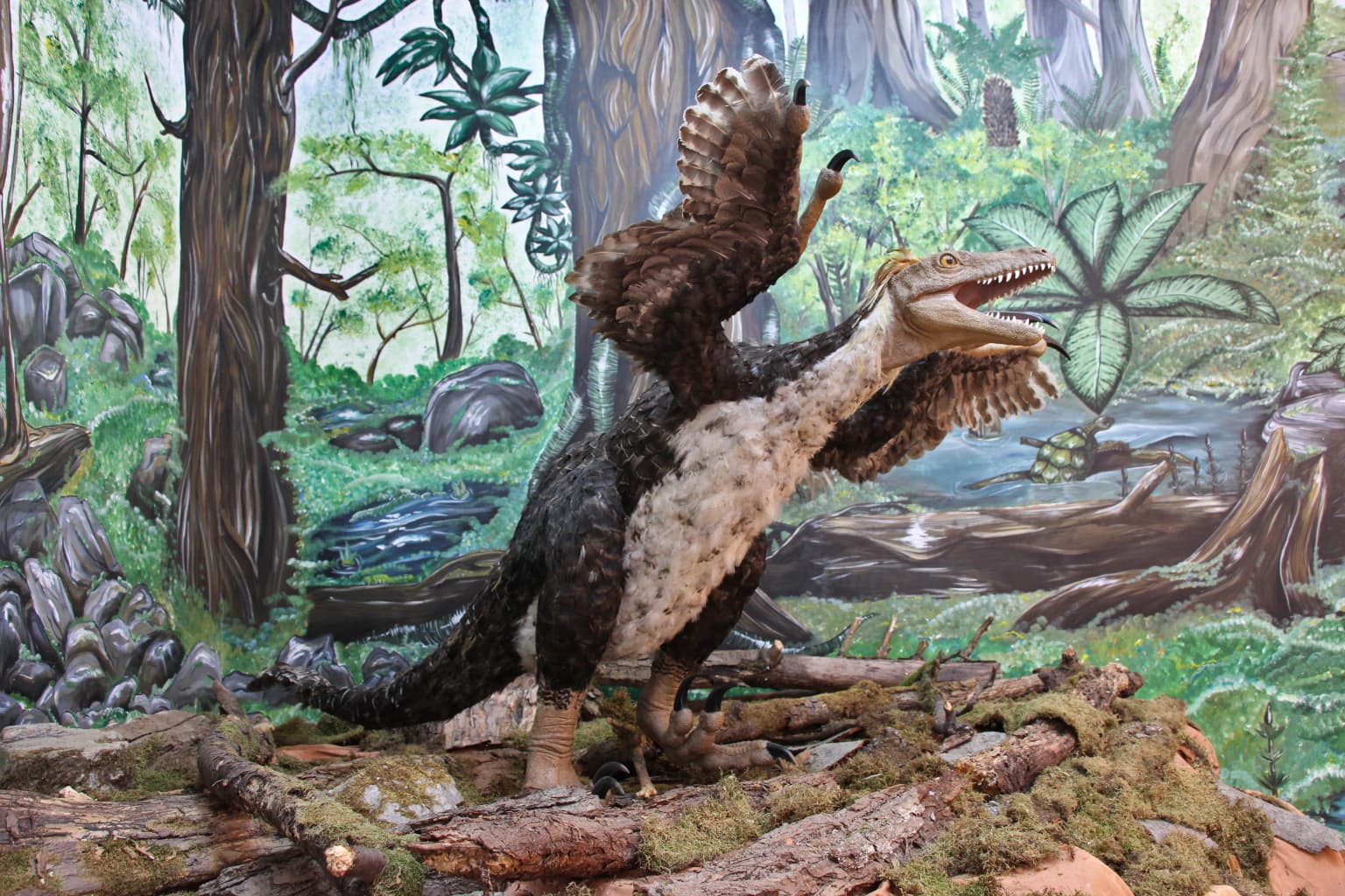
Why Hațeg Country Dinosaur Geopark stands out

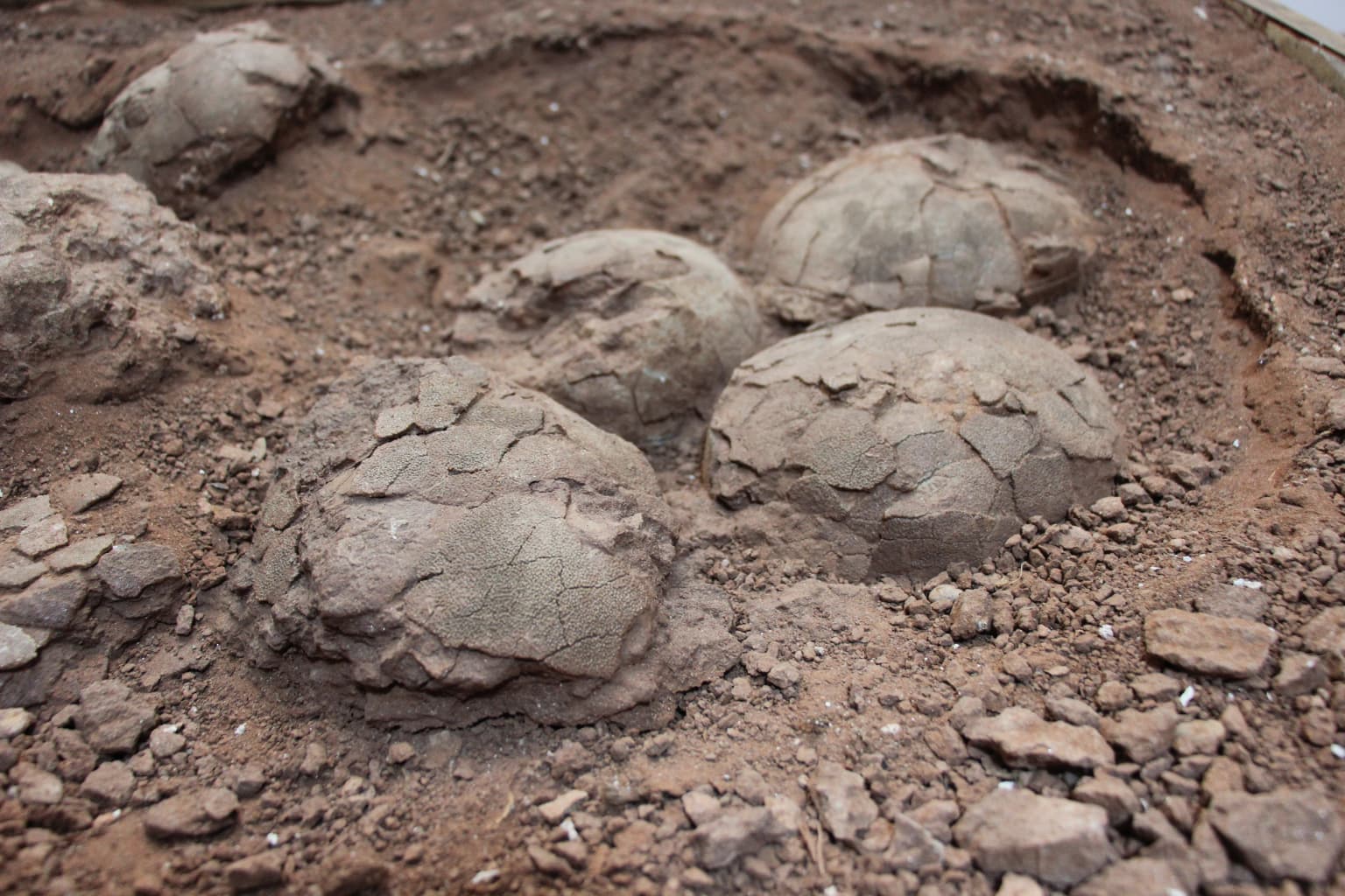
The geopark is best known for its exceptional Late Cretaceous dinosaur fossil sites, which have produced numerous species that are unique to the Hațeg region. The area has yielded well-preserved remains of ornithopod dinosaurs, theropods, and other prehistoric fauna that inhabited this part of Europe during the final epochs of the dinosaur age. These discoveries have made Hațeg one of the premier dinosaur localities on the continent, with findings that have contributed substantially to scientific understanding of European Cretaceous ecosystems.

Close-up of fossilized egg shells and nest structure in a dirt excavation site
Fossilized Telmatosaurus nest and eggs in situ at Hațeg Country Dinosaur Geopark

Hațeg Country Dinosaur Geopark history and protected-area timeline

The paleontological significance of the Hațeg region was first recognized in the late 19th and early 20th centuries, when initial fossil discoveries drew the attention of European scientists. Systematic excavation and research over subsequent decades revealed the true scope of the region's dinosaur heritage, identifying multiple species that were endemic to this ancient island environment. The formal recognition of Hațeg as a UNESCO Global Geopark reflected decades of research progress and growing appreciation for both the scientific and educational value of the area. The geopark designation has supported ongoing research while also promoting sustainable development of the surrounding communities through geotourism and educational programs.

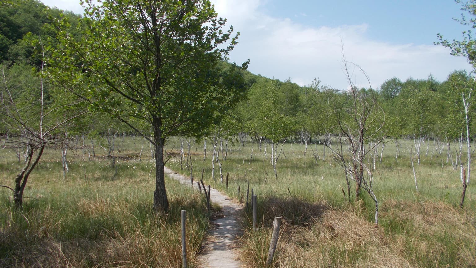
Hațeg Country Dinosaur Geopark landscape and geographic character

The Hațeg Depression is a basin surrounded by mountain ranges, characterized by a landscape of fertile valleys, rolling hills, and the corridors of rivers that have carved their way through the sedimentary terrain. The geological formations visible throughout the geopark include layers of sandstone, conglomerate, and shale that preserve the fossil remains within their ancient strata. The landscape maintains a traditional agricultural character, with villages, farmlands, and forests interspersed across the terrain. The geological exposures created by erosion and road cuts provide windows into the deep past, revealing the ancient environments where dinosaurs once thrived.

Boardwalk trail winding through a grassy wetland with scattered trees and distant forest under a partly cloudy sky

Hațeg Country Dinosaur Geopark ecosystems, habitats, and plant life

The natural environment of Hațeg Country Dinosaur Geopark reflects the ecological diversity of the Carpathian region, encompassing forests, grasslands, and wetland areas that support a range of plant and animal communities. While the geological and paleontological resources represent the primary scientific focus of the geopark, the modern ecosystem includes species typical of central European deciduous forests and meadow environments. The transition between different habitat types creates ecological variety that complements the geological attractions of the area.

A life-sized model of the Balaur bondoc dinosaur standing in a prehistoric forest diorama with trees, rocks, and a stream
Reconstruction of Balaur bondoc dinosaur at the Hațeg Country Dinosaur Geopark museum

Hațeg Country Dinosaur Geopark wildlife and species highlights

The contemporary wildlife of the Hațeg region includes species typical of Romania's Carpathian forests and agricultural landscapes. While the dinosaur fossils represent extinct fauna from the Cretaceous period, the modern area supports populations of mammals, birds, and other animals that inhabit the forests, meadows, and river corridors. The region's position along migration routes also brings seasonal visitors among bird populations.

Hațeg Country Dinosaur Geopark conservation status and protection priorities

Hațeg Country Dinosaur Geopark operates under UNESCO Global Geopark status, which recognizes its geological heritage while promoting sustainable development and environmental education. The protection framework supports ongoing paleontological research while also preserving the geological formations that contain fossil specimens. Conservation efforts within the geopark balance scientific investigation with the protection of irreplaceable fossil sites and the broader landscape character of the Hațeg Depression.

Hațeg Country Dinosaur Geopark cultural meaning and human context

The Hațeg region contains cultural heritage elements that predate its scientific fame, including medieval villages, historic churches, and traditional agricultural landscapes. The communities that have lived in this part of Romania for generations maintain cultural practices and architectural styles that reflect the region's position at the crossroads of central and eastern European traditions. This human heritage adds depth to the geopark experience, connecting visitors to the long history of human presence in this distinctive landscape.

Top sights and standout views in Hațeg Country Dinosaur Geopark

The exceptional Late Cretaceous dinosaur fossils, unique endemic species discoveries, UNESCO Global Geopark designation, accessible geological formations, integration of paleontological and cultural heritage, and the traditional Transylvanian landscape combine to create a distinctive destination for scientific tourism and educational visits.

Best time to visit Hațeg Country Dinosaur Geopark

The spring and autumn seasons offer comfortable conditions for exploring the geopark's outdoor sites and geological exposures. Summer months provide the warmest weather for extended field visits, while the winter season offers a quieter experience though with more limited access to some outdoor areas. The four seasons each present different aspects of the region's character, from summer's lush landscapes to winter's stark geological exposures.

Park location guide

Geography guide, regional context, and park location map for Hațeg Country Dinosaur Geopark

Hațeg Country Dinosaur Geopark park geography, regions, and map view in Romania
Understand where Hațeg Country Dinosaur Geopark sits in Romania through a broader geographic reading of the surrounding landscape, nearby location context, and its mapped position within the national park landscape.

How Hațeg Country Dinosaur Geopark fits into Romania

Romania is a unitary semi-presidential republic located in Southeast and Central Europe. It borders Ukraine, Hungary, Serbia, Bulgaria, Moldova, and the Black Sea. The country has a population of approximately 19 million and covers an area of 238,397 km². Bucharest is the capital and largest city. Romania joined the European Union in 2007.

Wider geography shaping Hațeg Country Dinosaur Geopark in Romania

Romania lies on the lower course of the Danube River, north of the Balkan Peninsula, and on the northwestern shore of the Black Sea. The terrain is varied, featuring the Carpathian Mountains in the center, the Transylvanian Plateau, the Moldavian Plateau, and plains along the Danube and in the south. The country has a diverse landscape that includes forests, meadows, and wetland areas.

Map view of Hațeg Country Dinosaur Geopark

Use this park location map to pinpoint Hațeg Country Dinosaur Geopark in Romania, understand its exact geographic position, and read its mapped placement within the surrounding landscape more clearly.

Pigeon | © OpenStreetMap contributors

Browse the diverse geological formations, ancient habitats, and traditional village landscapes defining Hațeg Country Dinosaur Geopark's visual identity.

Hațeg Country Dinosaur Geopark Photos: Explore Romania's Ancient Landscapes, Habitats, and Geopark Scenery
Explore comprehensive imagery showcasing Hațeg Country Dinosaur Geopark's distinctive landscapes, from rolling hills and river valleys to its significant Late Cretaceous fossil sites in Transylvania. Gain a clearer understanding of the park's geological heritage, diverse habitats, and overall protected-area character through a visual overview of its unique natural environment.

Close-up of fossilized egg shells and nest structure in a dirt excavation site

Grassy field with yellow wildflowers extending to a hilltop with scattered trees under a blue sky with clouds

Boardwalk trail winding through a grassy wetland with scattered trees and distant forest under a partly cloudy sky

A life-sized model of the Balaur bondoc dinosaur standing in a prehistoric forest diorama with trees, rocks, and a stream

Park atlas

Compare nearby protected landscapes, tracing the regional spread of natural heritage across Romania's varied Transylvanian terrain.

Find Other Protected Areas and National Parks Near Hațeg Country Dinosaur Geopark, Romania
Browse a curated list of protected areas and national parks situated close to Hațeg Country Dinosaur Geopark, extending your exploration of Romania's unique geological heritage and conservation landscapes. Gain valuable geographic context by comparing diverse protected landscapes, understanding their distribution, and mapping their unique features across the broader Transylvanian region.
Protected landscapeHunedoara County

Grădiștea Muncelului-Cioclovina Natural Park: Protected Landscape in Hunedoara County Atlas

Explore protected area geography and mapped boundaries.

Gain a structured understanding of Grădiștea Muncelului-Cioclovina Natural Park, a significant protected landscape located in Romania's Hunedoara County. This resource details its geographic position and mapped protected area extent, providing essential context for atlas exploration and regional landscape analysis. It serves as a focused entry point for understanding the park's unique geographic identity within its natural setting.

Area
381.84 km²
Established
2000
IUCN
V
Relief
Mountain
Watercolor illustration of a mountain range with forests, a lake, and distant hills under a light sky
National parkHunedoara County

Retezat National Park National Park: Protected Landscape and Regional Geography

Mapped boundaries and landscape context in Hunedoara County.

Retezat National Park is a key protected area featured within MoriAtlas, offering structured geographic data and map-based insights. This national park's protected landscape is situated in Hunedoara County, Romania, contributing significantly to the regional topography and natural context of the Southern Carpathians. Explore its mapped boundaries and understand its role as a distinct natural entity.

Area
380.47 km²
Established
1935
IUCN
II
Relief
Mountain
Watercolor illustration showing a river flowing through a valley with green hills, trees, and snow-capped mountains in the background
National parkGorj County

Defileul Jiului National Park: Romania's Protected National Park Landscape in Gorj County

Explore maps, geography, and protected area context.

Defileul Jiului National Park is a vital protected natural area situated in Gorj County, Romania. This MoriAtlas page serves as a detailed entry point for understanding the park's specific geography, its mapped perimeters, and its significance within the regional landscape atlas. Discover the park's topographic features and its relationship to the surrounding terrain of the Southern Carpathians, providing essential context for geographic exploration.

Area
111.27 km²
Established
2005
IUCN
II
Relief
Mountain
Watercolor illustration of a river flowing through a valley with mountains and forests in the background
National park

Domogled-Valea Cernei National Park: National Park with Mapped Protected Landscape

Explore its protected boundaries and regional geography.

Domogled-Valea Cernei National Park is recognized as a National Park, offering a distinct protected landscape for atlas-based discovery. This page provides focused insights into its mapped geographic extent and the character of its natural terrain. Understand the park's role within Romania's protected areas network and its unique geographic identity. Utilize this structured view to navigate the park's features and its surrounding landscape context for informed exploration.

Area
612.11 km²
Established
2000
IUCN
II
Relief
Mountain
Watercolor illustration of a landscape with mountains, trees, and a river
Protected landscapeSibiu County

Cindrel Natural Park: Protected Landscape within Sibiu County's Regional Geography

Mapped natural landscapes and protected area context.

Delve into the protected landscape of Cindrel Natural Park, situated in Sibiu County, Romania. This page offers a detailed geographic perspective, highlighting the park's mapped boundaries and its role within the broader natural terrain of the Southern Carpathians. Understand the structured atlas data that defines Cindrel Natural Park and its regional significance for protected land discovery.

Area
98.73 km²
Established
2000
IUCN
V
Relief
Mountain
Watercolor illustration showing rolling hills, scattered trees, and a soft pink sky
Protected landscapeMehedinți County

Mehedinți Plateau Geopark Protected Landscape: Karst Geography and Regional Context

Explore Romania's unique limestone formations and karst landscapes.

The Mehedinți Plateau Geopark in Mehedinți County, Romania, is a significant protected landscape celebrated for its extensive karst features. This page offers detailed insights into the park's mapped boundaries, including its famous natural bridges like Podul lui Dumnezeu, vast limestone pavements, and cave systems. Understand its position within the broader regional geography of southwestern Romania, providing a solid foundation for atlas-driven exploration of this geologically rich area.

Area
1,065 km²
Established
2005
IUCN
V
Relief
Upland
Watercolor illustration of a landscape with mountains, forests, and a body of water
National park

Semenic-Cheile Carașului National Park: Romania's Protected Landscape Discovery

National Park Geography and Mapped Boundaries

Delve into Semenic-Cheile Carașului National Park, a protected landscape in Romania, with a focus on its atlas and geographic context. This page details the park's identity as a national park, its specific mapped boundaries, and its contribution to regional geographic understanding. Utilize MoriAtlas to explore the structured data that defines this protected area and its surrounding natural terrain, enhancing your comprehension of Romania's conservation landscapes.

IUCN
II
Scope
Terrestrial
Protected landscapeSibiu County

Dumbrava Sibiului Natural Park: Protected Landscape Atlas and Geographic Discovery

Explore the mapped natural terrain and regional context.

Dumbrava Sibiului Natural Park is a designated protected landscape offering a unique lens into Romania's natural geography. This entry provides detailed atlas-level information on the park's protected boundaries and its setting within Sibiu County, part of the historic Transylvania region. Understand the park's landscape character and its role in the regional geography through structured map data.

Area
9.93 km²
Established
2000
IUCN
V
Relief
Lowland

Common questions about visiting, size, designation, and location context for Hațeg Country Dinosaur Geopark

Hațeg Country Dinosaur Geopark FAQs for park facts, access, geography, and protected area context
Find quick answers about Hațeg Country Dinosaur Geopark, including protected-area facts, park geography, trail and visitor context, and how the park fits into its surrounding country and regional landscape.
MoriAtlas Explorer

Continue Your Protected Areas Search Across the Global Atlas

Deepen your exploration by continuing the structured search for national parks and protected areas worldwide. Utilize the comprehensive filtering capabilities to compare different conservation landscapes and refine your understanding of global park geography. Discover more about the distribution and characteristics of protected natural areas.

Global natural geography