Mori Atlas logo
Protected landscapeMehedinți Plateau Geopark

Discover unique mapped geography, limestone formations, and regional context within Mehedinți County.

Mehedinți Plateau Geopark: Romania's Premier Karst Protected Landscape

(Geoparcul Platoul Mehedinți)

The Mehedinți Plateau Geopark, a protected landscape spanning Mehedinți County, Romania, invites detailed exploration of its extraordinary karst formations. This extensive natural area is defined by remarkable limestone pavements, sinkholes, natural bridges, and caves, making it a significant geological site. Positioned between the Southern Carpathians and the Getic Piedmont, the geopark offers a unique blend of terrain and biodiversity within a mapped regional context for atlas-based discovery.

Karst landscapeGeoparkLimestone formationsNatural bridgeCavesNatura 2000 site
Illustration of a natural rock arch formation surrounded by mountains, forests, and a waterfall

Mehedinți Plateau Geopark

Protected landscape

Park overview

Structured park overview, official facts, and landscape profile for Mehedinți Plateau Geopark

Mehedinți Plateau Geopark park facts, protected area profile, and essential visitor context
Review the core facts for Mehedinți Plateau Geopark, including designation, size, terrain, visitor scale, habitats, and operating context in one park-focused overview.

About Mehedinți Plateau Geopark

The Mehedinți Plateau Geopark occupies a distinctive position in Romania's protected area network as a landscape that seamlessly integrates exceptional geological heritage with ecological diversity and cultural significance. Located in the southwestern part of the country, the protected area encompasses rolling hills, deep ravines, limestone cliffs, and forested valleys that together create a landscape of remarkable variety. The geological foundation consists of Jurassic-age limestone and crystalline schists that have been sculpted by karst processes over millions of years, producing one of the most complex karst systems in Romania. Within this landscape, visitors encounter phenomena ranging from dramatic natural bridges and pit caves to hidden valleys and underground river systems. The geopark's importance extends beyond geology to include biological diversity, with forests of beech and oak, karst grasslands, and aquatic habitats supporting numerous species. The area also retains strong connections to traditional Romanian rural life, with numerous villages scattered across the plateau maintaining agricultural practices that have shaped the landscape for generations.

Quick facts and research context for Mehedinți Plateau Geopark

The Mehedinți Plateau Geopark covers 106,500 hectares in southwestern Romania, designated as IUCN Category V (protected landscape). The area is characterized by Jurassic limestone and crystalline schists forming extensive karst terrain. Within the geopark lie multiple protected natural sites including the famous Podul lui Dumnezeu (God's Bridge), Romania's largest natural bridge and Europe's second-largest. The park contains ten distinct habitat types and serves as a Natura 2000 site, protecting diverse flora and fauna across forests, grasslands, and karst formations.

Park context

Deeper park guide and search-rich context for Mehedinți Plateau Geopark

Mehedinți Plateau Geopark history, landscape, wildlife, and travel context
Explore Mehedinți Plateau Geopark through its history, landscape character, ecosystems, wildlife, conservation priorities, cultural context, and seasonal travel timing in a structured park guide built for atlas discovery and search intent.

Why Mehedinți Plateau Geopark stands out

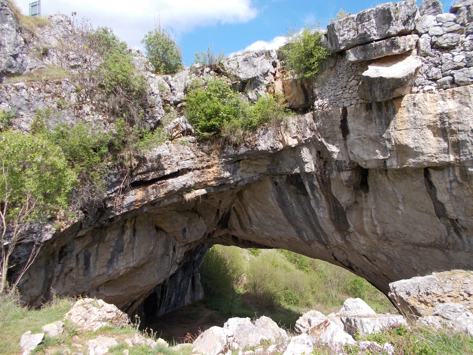
The Mehedinți Plateau Geopark is best known for its exceptional karst landscape, which ranks among Romania's most significant geological formations. The standout feature is Podul lui Dumnezeu (God's Bridge), a massive natural arch at Ponoarele that is the largest in Romania and the second-largest in Europe. The park also preserves the Complexul carstic de la Ponoarele, a karst complex containing rare geological formations including limestone pavement fields (lapiezuri), sinkholes (doline), and extensive cave systems. The combination of geological significance, biodiversity, and well-preserved traditional rural landscapes makes this geopark distinctive among Romania's protected areas.

Wide landscape view of rolling green hills and valleys with scattered buildings under a partly cloudy sky
Scenic view of rolling green hills and valleys in the Mehedinți Plateau Geopark

Mehedinți Plateau Geopark history and protected-area timeline

The Mehedinți Plateau Geopark was formally established through Government Decision Number 2152 on November 30, 2004, published in the Romanian Official Paper on January 12, 2005. This designation followed growing recognition of the area's geological and ecological significance, building upon earlier conservation efforts that had identified specific sites within the plateau for protection. The creation of the geopark reflected Romania's broader movement toward establishing protected landscapes that balance human use with conservation objectives. As a Category V protected area under IUCN classification, the geopark was specifically designed to maintain the harmonious interaction between people and nature while preserving ecological processes, cultural traditions, and scenic beauty. The designation also aligned with European environmental frameworks, with the area subsequently designated as a Natura 2000 site to protect its biodiversity and habitat types. Ongoing conservation work includes monitoring of karst formations, habitat restoration, and collaborative management involving local communities.

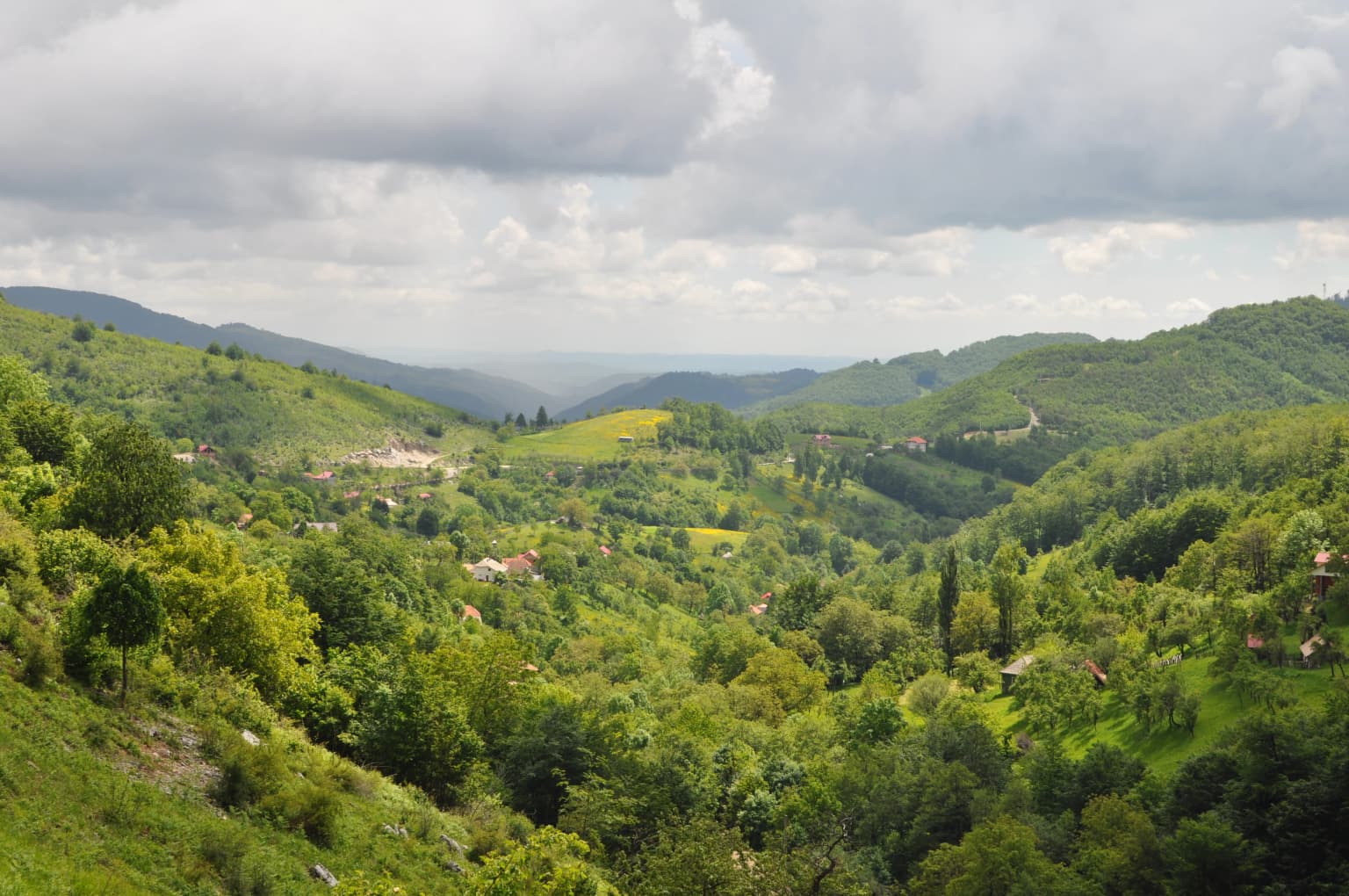
Mehedinți Plateau Geopark landscape and geographic character

The landscape of the Mehedinți Plateau Geopark presents a compelling blend of karst topography and rolling hill terrain that defines much of southwestern Romania's character. The plateau surface consists of gentle domed hills and wider valleys carved through limestone, with elevation varying across the area to create visual diversity. The most striking geological features emerge where water has dissolved the limestone to form karst phenomena: extensive limestone pavements called lapiezuri where surface rock has been grooved by dissolution, deep sinkholes (doline) that punctuate the terrain, and the remarkable Podul lui Dumnezeu natural bridge where a cave roof has collapsed to create a dramatic arch. Steep cliffs and rocky outcrops called cornets rise above valleys in several locations, while deeper ravines and gorges cut through the limestone layers. Forest cover dominates the slopes and higher ground, alternating with pastoral meadows and hay fields in the valleys. Two significant lakes, Zătonul Mare and Zătonul Mic, add still water to the landscape. The area transitions between the higher Mehedinți Mountains to the northwest and the more gentle Getic Piedmont to the east and south.

Natural stone arch bridge with vegetation on top and rocky terrain in the background under a blue sky
Natural stone arch known as God's Bridge in the Ponoarele Karst Complex

Mehedinți Plateau Geopark ecosystems, habitats, and plant life

The nature of the Mehedinți Plateau Geopark reflects the complex interactions between its karst geology, varied topography, and position within the continental biogeographic region. The protected area supports ten distinct habitat types recognized under European conservation frameworks, including beech forests of the Cephalanthero-Fagion type, Tilio-Acerion slope forests, Illyrian beech forests, oak-hornbeam forests, Luzulo-Fagetum beech forests, dry semi-natural grasslands on calcareous substrates, hygrophilous tall herb fringe communities, montane hay meadows, subcontinental peri-Pannonic scrub, and caves closed to public access. Vegetation follows the geological and altitudinal patterns, with beech (Fagus sylvatica) and sessile oak (Quercus petraea) forming the primary forest communities, accompanied by manna ash (Fraxinus ornus), Cornelian cherry (Cornus mas), Oriental hornbeam (Carpinus orientalis), and various shrubs. The orchid flora is particularly notable, with species including Limodorum abortivum, Cephalanthera damasonium, various Spiranthes and Orchis species, and the rare Fritillaria montana. The limestone cliffs and rocky areas support specialized plant communities adapted to karst conditions.

Mehedinți Plateau Geopark wildlife and species highlights

The wildlife community of the Mehedinți Plateau Geopark encompasses a diverse assembly of species across mammals, birds, reptiles, amphibians, and invertebrates that inhabit the forest, grassland, karst, and aquatic environments. Among mammals, the area supports populations of wolf (Canis lupus), red fox (Vulpes vulpes), red deer (Cervus elaphus), roe deer (Capreolus capreolus), wildcat (Felis silvestris), pine marten (Martes martes), European hare (Lepus europaeus), red squirrel (Sciurus vulgaris), and several bat species including Daubenton's bat (Myotis daubentonii), greater horseshoe bat (Rhinolophus ferrumequinum), and common mouse-eared bat (Myotis myotis). The avifauna includes great spotted woodpecker (Dendrocopus major), golden oriole (Oriolus oriolus), nightingale (Luscinia megarhynchos), jay (Garrulus glandarius), blackbird (Turdus merula), and numerous other species. Reptile and amphibian populations feature horned viper (Vipera ammodytes), smooth snake (Coronella austriaca), Hermann's tortoise (Testudo hermanni), yellow-bellied toad (Bombina variegata), crested newt (Triturus cristatus), and fire salamander (Salamandra salamandra). Many of these species receive protection under the EU Habitats Directive.

Mehedinți Plateau Geopark conservation status and protection priorities

The conservation significance of the Mehedinți Plateau Geopark derives from its combination of rare geological formations, diverse habitats, and the species they support. The area is designated as a Natura 2000 site (SCI) specifically for the Mehedinți Plateau, acknowledging its importance for maintaining European biodiversity. The ten habitat types present within the geopark include several of community interest under the EU Habitats Directive, requiring conservation measures to maintain their favorable condition. Several specific sites within the geopark hold independent protected status as nature reserves, including the Complexul carstic de la Ponoarele (karst complex), Pădurea cu liliac Ponoarele (lilac forest), Cheile Coșuștei (gorges), and Epuran Cave. The karst formations, particularly the Podul lui Dumnezeu, represent geological features of national importance that require protection from both natural and human-induced threats. Conservation challenges include managing the ongoing human presence within the area, balancing traditional land use with ecological requirements, and addressing the vulnerability of karst systems to pollution and disturbance.

Mehedinți Plateau Geopark cultural meaning and human context

The cultural context of the Mehedinți Plateau Geopark reflects centuries of human presence that have shaped and been shaped by this karst landscape. The plateau has supported agricultural communities since medieval times, with villages such as Ponoarele, Bala, Balta, and others maintaining rural settlements that incorporate traditional building practices and land management patterns. The area contains numerous wooden churches (biserici de lemn) that represent important cultural heritage, many dating to the 18th and 19th centuries. Notable examples include the Church of St. Nicholas in Ponoarele (1766), the Church of the Holy Trinity in Gărdăneasa (1887), and the Baia de Aramă Monastery complex (1699-1703). These religious structures, along with former monastic settlements like Schitu Topolnița, demonstrate the spiritual significance of the landscape. Traditional practices of pastoralism, hay-making, and small-scale agriculture continue in the area, maintaining the cultural landscape character that distinguishes this protected area. The villages also preserve folk traditions, local dialects, and traditional crafts that contribute to the region's cultural identity.

Top sights and standout views in Mehedinți Plateau Geopark

The Mehedinți Plateau Geopark offers exceptional highlights for visitors interested in karst landscapes, geological wonders, and traditional Romanian culture. The Podul lui Dumnezeu natural bridge at Ponoarele stands as the premier attraction, a massive limestone arch spanning a small valley and representing one of Europe's most impressive natural bridges. The surrounding Ponoarele karst complex encompasses the largest limestone pavement field in Romania, where dissolution has carved intricate grooves into the exposed rock surface. Visitors can explore numerous caves including Peștera Ponoarele, Peștera Topolniței, and Peștera Epuran, each offering different geological features. The network of wooden churches distributed across the plateau provides cultural exploration opportunities, with structures spanning several centuries. The diverse landscapes, from forested slopes to karst meadows, support wildlife viewing opportunities, while the extensive trail network allows exploration of this relatively unspoiled corner of Romania.

Best time to visit Mehedinți Plateau Geopark

The Mehedinți Plateau Geopark can be visited throughout the year, though each season offers distinct experiences for visitors. Spring brings fresh vegetation and flowering meadows, particularly notable for the diverse orchid populations that bloom across the grasslands and forest edges from April through June. This season also offers pleasant temperatures for hiking and exploration. Summer provides the warmest conditions for outdoor activities, though afternoon thunderstorms are common in the karst landscape. The summer months see the meadows at their most verdant and the forests providing shade from the heat. Autumn transforms the forests into colorful displays as beech and oak leaves change, creating particularly scenic conditions, and this season often offers stable weather for continued visits. Winter reveals a different character, with snow occasionally covering the plateau and fewer visitors present to enjoy the quiet landscape. The karst caves maintain relatively constant temperatures year-round, making them potential destinations in any season.

Park location guide

Geography guide, regional context, and park location map for Mehedinți Plateau Geopark

Mehedinți Plateau Geopark park geography, regions, and map view in Romania
Understand where Mehedinți Plateau Geopark sits in Romania through a broader geographic reading of the surrounding landscape, nearby location context, and its mapped position within the national park landscape.

How Mehedinți Plateau Geopark fits into Romania

Romania is a unitary semi-presidential republic located in Southeast and Central Europe. It borders Ukraine, Hungary, Serbia, Bulgaria, Moldova, and the Black Sea. The country has a population of approximately 19 million and covers an area of 238,397 km². Bucharest is the capital and largest city. Romania joined the European Union in 2007.

Wider geography shaping Mehedinți Plateau Geopark in Romania

Romania lies on the lower course of the Danube River, north of the Balkan Peninsula, and on the northwestern shore of the Black Sea. The terrain is varied, featuring the Carpathian Mountains in the center, the Transylvanian Plateau, the Moldavian Plateau, and plains along the Danube and in the south. The country has a diverse landscape that includes forests, meadows, and wetland areas.

Map view of Mehedinți Plateau Geopark

Use this park location map to pinpoint Mehedinți Plateau Geopark in Romania, understand its exact geographic position, and read its mapped placement within the surrounding landscape more clearly.

Pigeon | © OpenStreetMap contributors

Location context for Mehedinți Plateau Geopark

Gorj CountyMehedinți County

A Visual Atlas of Romania's Remarkable Karst Topography and Diverse Habitats within the Mehedinți Plateau Protected Area

Mehedinți Plateau Geopark Photos: Explore Karst Landscapes, Natural Bridges, and Protected Scenery
Browse a comprehensive visual gallery showcasing the distinctive karst formations, dramatic natural bridges, and varied forested landscapes of Mehedinți Plateau Geopark. These images provide essential geographic context and visual insights into the park's unique protected environments and geological heritage in southwestern Romania.

Wide landscape view of rolling green hills and valleys with scattered buildings under a partly cloudy sky

Landscape view of the Mehedinți Plateau Geopark featuring karst pavement, rocky outcrops, and dense greenery under clear blue sky

Natural stone arch bridge with vegetation on top and rocky terrain in the background under a blue sky

Park atlas

Discover protected areas and regional landscapes near Mehedinți Plateau Geopark, comparing karst topography across southwestern Romania.

Explore Other National Parks and Protected Areas Near Mehedinți Plateau Geopark, Romania's Karst Landscape
Browse national parks and other protected areas located near Mehedinți Plateau Geopark, enabling exploration of similar karst landscapes and forest reserves across southwestern Romania. This comparative atlas view helps contextualize the geological heritage and diverse ecosystems of the Mehedinți region by showing adjacent protected zones.
National park

Domogled-Valea Cernei National Park: National Park with Mapped Protected Landscape

Explore its protected boundaries and regional geography.

Domogled-Valea Cernei National Park is recognized as a National Park, offering a distinct protected landscape for atlas-based discovery. This page provides focused insights into its mapped geographic extent and the character of its natural terrain. Understand the park's role within Romania's protected areas network and its unique geographic identity. Utilize this structured view to navigate the park's features and its surrounding landscape context for informed exploration.

Area
612.11 km²
Established
2000
IUCN
II
Relief
Mountain
Watercolor illustration of a river flowing through a valley with mountains in the background
Protected landscapeRomania

Iron Gates Natural Park: Explore Romania's Protected Landscape and Geographic Context

Detailed atlas view of a protected landscape in Romania.

Uncover the geographic dimensions of Iron Gates Natural Park, a protected landscape situated in Romania. This detailed entry offers an atlas-centric exploration of its mapped boundaries and regional setting, facilitating a deeper understanding of its protected status and landscape features within the national geography. Discover the park's intrinsic value through structured geographic data and visual map context.

Area
1,156.66 km²
Established
2000
Relief
Mixed relief
Climate
Mediterranean
Watercolor illustration of a mountain range with forests, a lake, and distant hills under a light sky
National parkHunedoara County

Retezat National Park National Park: Protected Landscape and Regional Geography

Mapped boundaries and landscape context in Hunedoara County.

Retezat National Park is a key protected area featured within MoriAtlas, offering structured geographic data and map-based insights. This national park's protected landscape is situated in Hunedoara County, Romania, contributing significantly to the regional topography and natural context of the Southern Carpathians. Explore its mapped boundaries and understand its role as a distinct natural entity.

Area
380.47 km²
Established
1935
IUCN
II
Relief
Mountain
National park

Đerdap National Park: Europe's Grandest River Gorge and Protected Landscape

Explore Serbia's largest national park along the Danube River.

Đerdap National Park is defined by the Iron Gate, Europe's longest and most dramatic river gorge, a geological marvel carved through the Carpathian Mountains. This protected area showcases a complex karst landscape with towering cliffs, deep river sections, and rich biodiversity, including vital Tertiary relict species. The park's vastness and unique terrain offer a profound geographic context for understanding regional natural landscapes and conservation efforts. Explore its mapped boundaries and ecological significance.

Area
637.87 km²
Established
1974
IUCN
II
Relief
Mountain
National parkGorj County

Defileul Jiului National Park: Romania's Protected National Park Landscape in Gorj County

Explore maps, geography, and protected area context.

Defileul Jiului National Park is a vital protected natural area situated in Gorj County, Romania. This MoriAtlas page serves as a detailed entry point for understanding the park's specific geography, its mapped perimeters, and its significance within the regional landscape atlas. Discover the park's topographic features and its relationship to the surrounding terrain of the Southern Carpathians, providing essential context for geographic exploration.

Area
111.27 km²
Established
2005
IUCN
II
Relief
Mountain
Protected landscapeHunedoara County

Grădiștea Muncelului-Cioclovina Natural Park: Protected Landscape in Hunedoara County Atlas

Explore protected area geography and mapped boundaries.

Gain a structured understanding of Grădiștea Muncelului-Cioclovina Natural Park, a significant protected landscape located in Romania's Hunedoara County. This resource details its geographic position and mapped protected area extent, providing essential context for atlas exploration and regional landscape analysis. It serves as a focused entry point for understanding the park's unique geographic identity within its natural setting.

Area
381.84 km²
Established
2000
IUCN
V
Relief
Mountain
Watercolor illustration depicting a landscape with mountains, a winding river, and grassy fields
Protected landscape

Vršac Mountains Protected Landscape: A Unique Pannonian Island Mountain Range in Serbia

Explore distinct geological formations and rich avian habitats.

The Vršac Mountains Protected Landscape offers a unique geographic perspective as one of Serbia's Pannonian island mountains, emerging dramatically from the surrounding plains. This protected area is recognized for its striking gneiss and schist formations, its status as Vojvodina's highest elevation, and its exceptional importance for birdwatching, hosting over 120 species. Delve into the mapped terrain and geological character that distinguish this vital natural region.

Area
170 km²
Established
1982
Relief
Mountain
Climate
Temperate
Watercolor illustration of a landscape with mountains, trees, and a river
Protected landscapeSibiu County

Cindrel Natural Park: Protected Landscape within Sibiu County's Regional Geography

Mapped natural landscapes and protected area context.

Delve into the protected landscape of Cindrel Natural Park, situated in Sibiu County, Romania. This page offers a detailed geographic perspective, highlighting the park's mapped boundaries and its role within the broader natural terrain of the Southern Carpathians. Understand the structured atlas data that defines Cindrel Natural Park and its regional significance for protected land discovery.

Area
98.73 km²
Established
2000
IUCN
V
Relief
Mountain

Common questions about visiting, size, designation, and location context for Mehedinți Plateau Geopark

Mehedinți Plateau Geopark FAQs for park facts, access, geography, and protected area context
Find quick answers about Mehedinți Plateau Geopark, including protected-area facts, park geography, trail and visitor context, and how the park fits into its surrounding country and regional landscape.
MoriAtlas Explorer

Continue Your Protected Areas Search Across the Global Atlas

Deepen your exploration by continuing the structured search for national parks and protected areas worldwide. Utilize the comprehensive filtering capabilities to compare different conservation landscapes and refine your understanding of global park geography. Discover more about the distribution and characteristics of protected natural areas.

Global natural geography