Mori Atlas logo
Protected landscapeIron Gates Natural Park

Explore the mapped boundaries and terrain of this significant protected landscape.

Iron Gates Natural Park: Discover the Protected Landscape and Regional Geography of Romania

(Parcul Natural Porțile de Fier)

Iron Gates Natural Park stands as a distinct protected landscape within Romania, offering a unique lens for geographic discovery. This page provides an atlas-driven perspective on its mapped boundaries and regional context, allowing you to understand its place in the broader natural and protected area network. Navigate the terrain and explore the geographic significance of Iron Gates Natural Park.

natural parkriver gorgewetlandssub-Mediterranean ecosystemsbirdwatchingendemic species
Illustrated view of a river flowing through a gorge between steep rock formations with green vegetation and pink flowers in the foreground

Iron Gates Natural Park

Protected landscape

Park overview

Structured park overview, official facts, and landscape profile for Iron Gates Natural Park

Iron Gates Natural Park park facts, protected area profile, and essential visitor context
Review the core facts for Iron Gates Natural Park, including designation, size, terrain, visitor scale, habitats, and operating context in one park-focused overview.

About Iron Gates Natural Park

Iron Gates Natural Park represents one of Romania's most significant protected landscapes, combining dramatic mountain scenery with extraordinary biodiversity and deep historical layers. The park occupies a strategic position along the Danube River, Europe's second-longest waterway, where the river has carved one of its most impressive gorges between the Carpathian Mountains. The landscape is dominated by the Banat Mountains to the north, comprising the Locva and Almăj mountain ranges, and the Mehedinți Mountains and plateau to the northeast. The southern boundary follows the Danube's navigation channel, which separates the Romanian park from Serbia's Đerdap National Park across the river.

The park's ecological character is defined by the convergence of different biogeographic provinces. The Danube gorge serves as a corridor allowing Mediterranean species to extend far north while mountain elements descend to lower elevations. This creates a complex mosaic of forest types, from oak-dominated woodlands in the lower elevations through beech forests to subalpine vegetation on higher slopes. The climate shows strong Mediterranean influences, particularly in the gorge area where summer temperatures regularly exceed 40°C while winter remains relatively mild. This thermal regime supports plant and animal species typically found much further south in Europe.

Beyond its natural values, the Iron Gates area holds profound historical significance. The Danube has served as a major transportation route since ancient times, and the gorge's strategic position made it a crucial boundary between different empires and civilizations. The region contains archaeological evidence spanning from Paleolithic times through the Dacian and Roman periods to medieval fortifications. The famous 40-meter rock sculpture of King Decebalus, completed in 2005, stands as a modern monument to the region's ancient heritage, visible from the river below.

Quick facts and research context for Iron Gates Natural Park

Iron Gates Natural Park occupies 115,666 hectares along the Danube River in southwestern Romania, making it the second-largest natural park in the country. The park encompasses 18 protected areas, with the Ostrov-Moldova Veche wetland zone being the largest. It spans across Caraș-Severin and Mehedinți counties, from the western settlement of Socol to Drobeta-Turnu Severin in the east. The maximum elevation reaches 968 meters at Teiul Moșului peak in the Almăj Mountains. The area experiences a modified Mediterranean climate with warm, dry summers and mild, wet winters, with average temperatures around 11°C. The park was formally established in 2000 and serves as an important corridor linking the Pannonian Plain to the Romanian Plain.

Park context

Deeper park guide and search-rich context for Iron Gates Natural Park

Iron Gates Natural Park history, landscape, wildlife, and travel context
Explore Iron Gates Natural Park through its history, landscape character, ecosystems, wildlife, conservation priorities, cultural context, and seasonal travel timing in a structured park guide built for atlas discovery and search intent.

Why Iron Gates Natural Park stands out

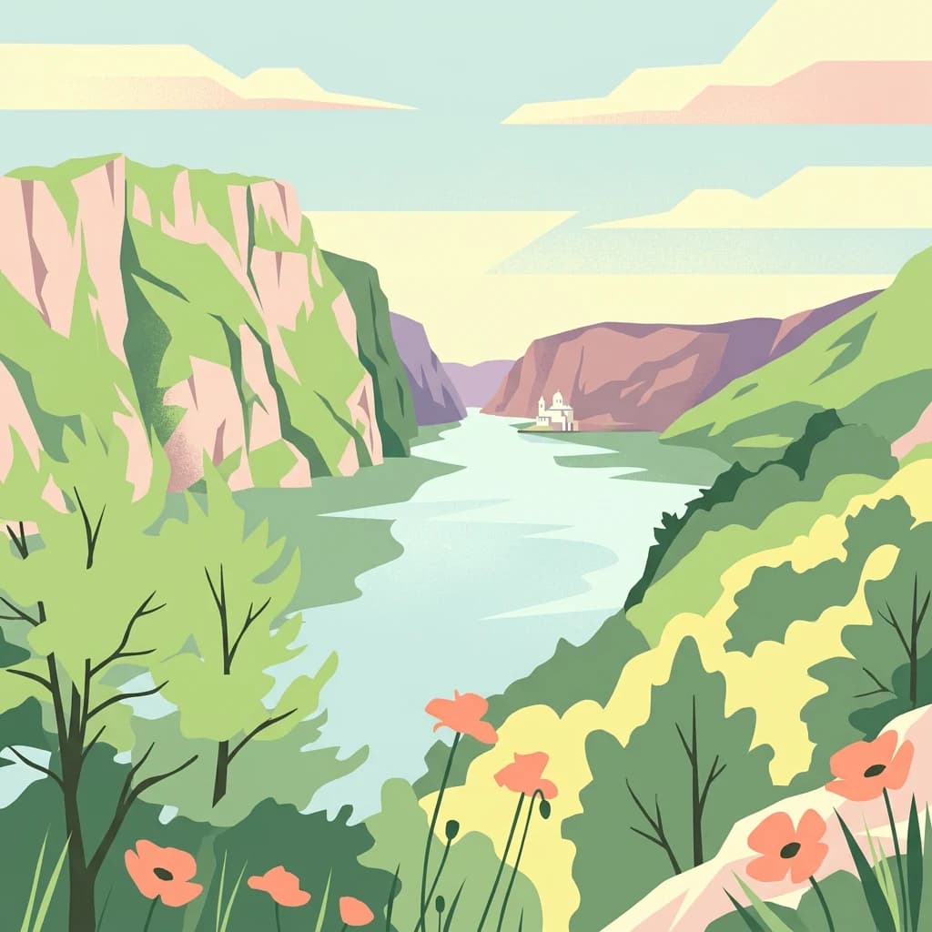
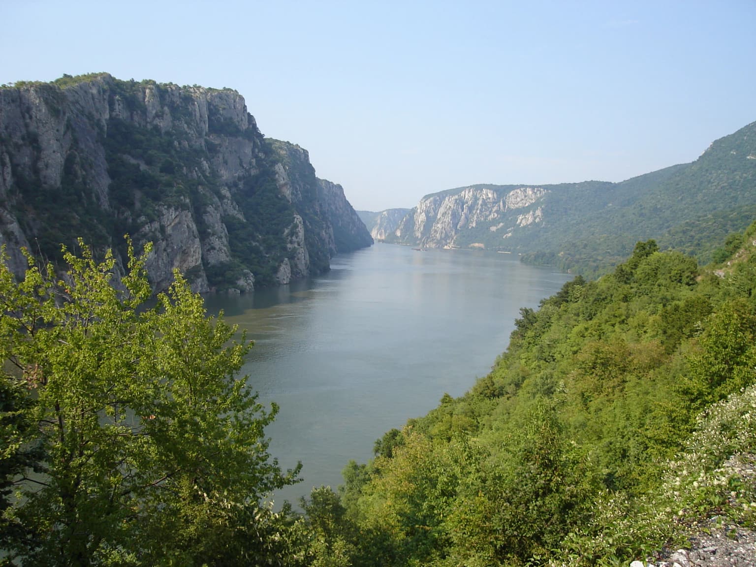
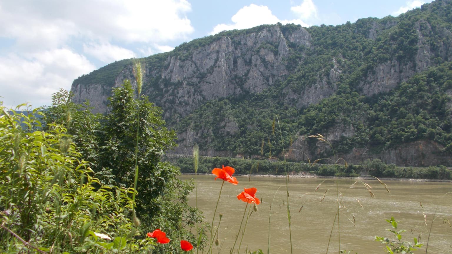
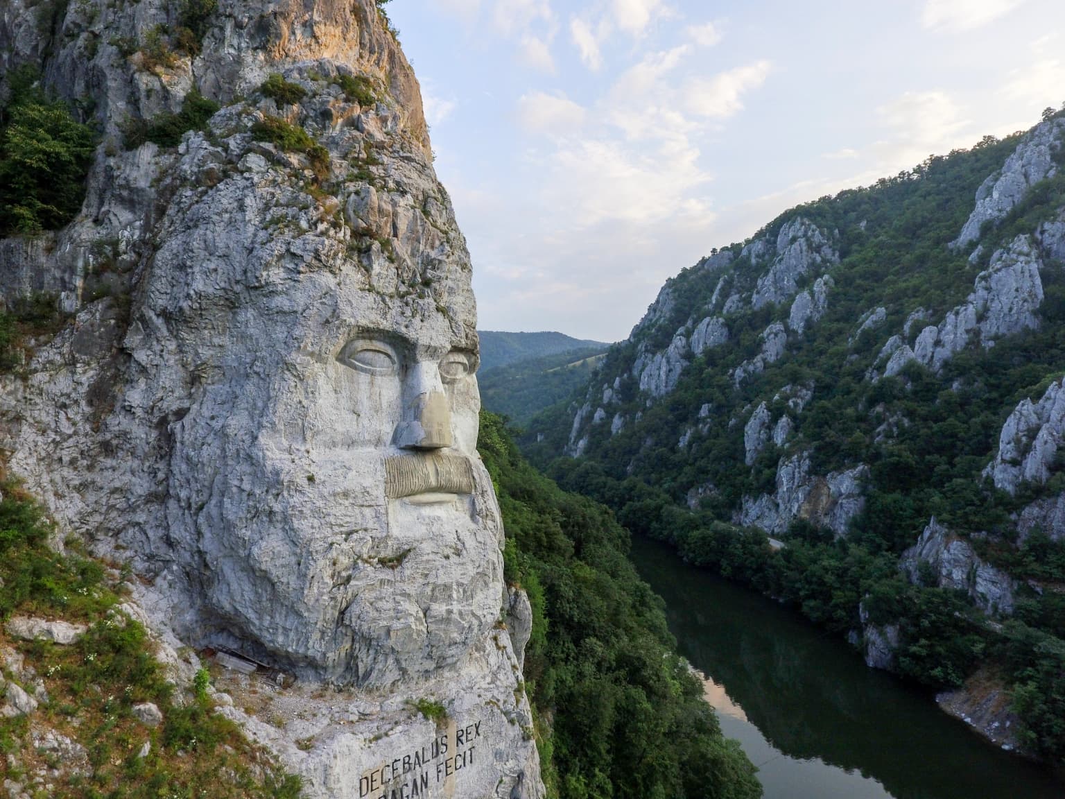
Iron Gates Natural Park is best known for its dramatic Iron Gates gorge, where the Danube River cuts through a spectacular limestone landscape creating the famous Cazanele Dunării (Great and Little Canyons). The park is renowned for its exceptional biodiversity and sub-Mediterranean character, hosting nearly half of all plant species found in Romania within its boundaries. It is famous for endemic flora including Tulipa hungarica (the Danube tulip), one of Romania's most iconic protected flowers. The wetland areas created by the Iron Gates I dam serve as crucial habitats for waterfowl, supporting over 200 bird species. The park also contains remarkable archaeological sites including the massive rock-carved sculpture of Decebalus, the last Dacian king, overlooking the Danube.

Wide river flanked by rocky cliffs and green vegetation under a clear blue sky.
Danube River flowing through the Iron Gate gorge with steep rocky cliffs and lush green vegetation.

Iron Gates Natural Park history and protected-area timeline

Iron Gates Natural Park was formally established through Romania's Law No. 5 from March 6, 2000, which approved the national territorial planning section covering protected areas. However, the protected status of this area was recognized earlier, with initial designations dating to 1990. The park's creation followed growing recognition of the region's exceptional natural values and the need to coordinate protection across the complex landscape spanning two counties.

The creation of the Iron Gates I dam between 1964 and 1972 fundamentally transformed the area's hydrology and ecology. The massive reservoir, stretching 130 kilometers with a surface area of 700 square kilometers, inundated the original riverbed and transformed the mouths of tributaries into new wetland areas. This environmental change, while disrupting some original ecosystems, created new habitats for waterfowl and aquatic species that now constitute some of the park's most valuable conservation areas.

The Iron Gates region has been a protected area under various designations for decades, with the recognition of the Ostrov-Moldova Veche wetland zone as a Ramsar site in 2009 marking the park's international conservation significance. The park's management framework coordinates multiple protected zones of different categories, including botanical reserves, mixed-use areas, and avifaunistic protection zones, all working within the broader natural park designation.

Iron Gates Natural Park landscape and geographic character

The landscape of Iron Gates Natural Park is dominated by the dramatic topography where the Danube River has cut a spectacular gorge through the Carpathian Mountains. The river enters the area from the west after flowing through the Serbian Đerdap gorge and maintains its general eastward course through the Romanian Iron Gates, though the navigation channel is now submerged beneath the reservoir. The most striking features are the Cazanele Mari (Great Canyons) and Cazanele Mici (Little Canyons), where limestone cliffs rise steeply from the water's edge.

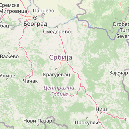
The northern boundary is formed by mountain ranges belonging to the Banat Mountains. The Locva Mountains extend from the Nera River in the west to the Camenița Valley in the east, with their highest point at Poiana Lisa (547.7 meters). The Almăj Mountains lie to the east, reaching the park's maximum elevation of 968 meters at Teiul Moșului. The Mehedinți Mountains and the Mehedinți Plateau extend along the northeastern portion of the park. Between these ranges, the Moldova Nouă depression provides a lower-lying area that includes the Calinovăț island, now a wetland area.

The geological structure reflects the complex tectonic history of the Carpathians, with major units including the Danubian Units in the central and eastern areas, the Severin Nappe along the Orșova to Drobeta-Turnu Severin sector, the Getic Nappe in the western portion, and the Supragetic Nappe. This varied geology produces diverse landforms including karst features, steep cliffs, forested slopes, and the wetland areas along the Danube reservoir.

Red poppies, green vegetation, Danube River, rocky cliffs, partly cloudy sky
Red poppies in the foreground with the Danube River and Iron Gates gorge in the background

Iron Gates Natural Park ecosystems, habitats, and plant life

Iron Gates Natural Park represents a remarkable ecological crossroads where multiple biogeographic regions converge, creating vegetation communities of exceptional diversity and complexity. The park occupies the Danube gorge corridor connecting the Pannonian Plain to the Romanian Plain, allowing species from Mediterranean, Central European, and Balkan origins to coexist in a relatively restricted area. This convergence zone produces sub-Mediterranean vegetation types found nowhere else in Romania.

The vegetation structure follows a clear altitudinal pattern. The beech forest sub-zone occupies elevations between 500 and 1000 meters, dominated by European beech with occurrences of Taurus beech, Moesian beech, and Oriental beech. Below 300 meters, mixed forests with thermophilic elements become dominant, featuring species such as Turkey oak, Hungarian oak, pubescent oak, and Eastern hornbeam. The park contains significant populations of the endemic Banat black pine (Pinus nigra subsp. banatica), particularly on thin-soiled rocky areas.

The park hosts approximately half of all plant species found throughout Romania, distributed among 171 plant associations across 20 vegetation classes, with 26 of these being endemic. The most botanically significant area is the Cazanele zone, where the critically protected Tulipa hungarica (Danube tulip) grows on the steep cliffs of Ciucaru Mare. This species is endemic to the Iron Gates area and is listed on the IUCN Red List. Other endemic species include Banat cornflower, Cosaci, Danube steppe grass, Banat pink, Hungarian beautyhead, Cazanele bells, and Dacic rowan.

A brown-headed duck with white body and dark wings swimming in greenish water
Common Pochard duck swimming in calm water

Iron Gates Natural Park wildlife and species highlights

Iron Gates Natural Park supports impressive biodiversity with 205 bird species and 34 mammal species documented within its boundaries. The mammalian fauna includes both large carnivores and smaller species characteristic of Carpathian forests. The brown bear, wolf, and Eurasian lynx all occur in the park's forested mountainous areas, representing some of Europe's most conservation-significant predators. Smaller carnivores include the European polecat, European badger, and pine marten. The ungulate community features red deer, roe deer, and wild boar, providing prey species for the larger predators.

The avifauna is particularly significant, with 205 species recorded including many of conservation importance. The wetland habitats created by the Iron Gates reservoir support important populations of waterfowl and wading birds. Species of special conservation concern include the ferruginous duck, greater spotted eagle, and lesser kestrel, all protected under the Bonn Convention. Of the 205 bird species, 133 are strictly protected under the Bern Convention's Annex II, while 37 have protection status under Annex III.

The reptile and amphibian communities include 14 amphibian species and 17 reptile species. The Hermann's tortoise represents an emblematic species for the park, while other reptiles include the Pontic lizard, wall lizard, Tauric lizard, green lizard, yellow-bellied toad, and the venomous horned viper. The park's caves, particularly Peștera Veterani, Peștera Ponicova, and Peștera Gaura cu Muscă, provide important roosting sites for bats representing Mediterranean-origin species.

Large stone face carving on a cliffside with a river and mountainous landscape below
Rock carving of Decebal's face overlooking the Danube River in Iron Gates Natural Park

Iron Gates Natural Park conservation status and protection priorities

Iron Gates Natural Park holds significant conservation importance at both national and international levels, recognized through its Ramsar designation in 2009 as a Wetland of International Importance. The park protects representative examples of the sub-Mediterranean ecosystems found in Romania's Danube gorge corridor, a biome type with very limited representation in the country's protected area network. The combination of Mediterranean climate influences, unique geological substrate, and the complex history of species migration has produced ecological communities of high conservation value.

The protection of endemic species represents a key conservation priority. Tulipa hungarica, the Danube tulip, is protected by Romanian law and listed on the IUCN Red List as vulnerable. The species occurs only in the Iron Gates area, growing on the steep limestone cliffs where it is vulnerable to disturbance and habitat change. The park's multiple protected zones, spanning botanical reserves, avifaunistic areas, and mixed-use sites, provide targeted protection for different conservation values across the landscape.

The Ramsar designation specifically recognizes the wetland habitats created by the Iron Gates reservoir, which now provide crucial habitat for migratory waterfowl and resident wetland species. These areas serve as important staging and wintering grounds for birds moving along the Danube migration corridor between Central and Southern Europe. The conservation framework integrates both the wetland and terrestrial components, recognizing the ecological connectivity between the river system and the surrounding mountain forests.

Iron Gates Natural Park cultural meaning and human context

The Iron Gates region has been a crossroads of civilizations throughout human history, with the Danube serving as a major transportation and trade route connecting the Balkans to Central Europe. Archaeological evidence includes remains from the Paleolithic and Neolithic periods, as well as the Proto-Dacian and Dacian cultures that flourished in the region before Roman conquest. The rock shelter at Peștera Gaura Chindiei II contains evidence of human occupation from these ancient periods.

The area contains several historic monastic establishments reflecting the region's religious heritage. Mănăstirea Vodița, founded between 1370 and 1372 by the Greek-Serbian monk Nicodim, represents one of the oldest monastic foundations in the area. The monastery played a significant role in the cultural development of the region and later served as the foundation for Mănăstirea Tismana. Other significant religious sites include Mănăstirea Mraconia, the Church of Saint Nicholas the Poor in Orșova, and the Sfânta Ana Monastery built on Dealul Moșului between 1936 and 1939.

The human population within the park numbers approximately 45,735 residents, distributed across several communities including Orșova and Moldova Nouă as the main population centers. The population includes multiple ethnic groups: Romanians as the majority, followed by Serbs in the western portion, Czech communities in areas such as Bigăr and Eibenthal, and smaller populations of Hungarians, Germans, and Roma. This cultural diversity reflects the historical layers of settlement in this border region.

Muddy river flowing into a wider waterway with grassy banks and mountains in the distance
Cerna River flowing into the Danube River with mountains in the background

Top sights and standout views in Iron Gates Natural Park

Iron Gates Natural Park offers several standout features that define its character and appeal. The dramatic Cazanele Dunării (Great and Little Canyons) represent the park's most visually spectacular landscape, where the Danube flows between towering limestone cliffs. The rare Danube tulip (Tulipa hungarica) blooms on these cliff faces, one of Romania's most cherished endemic flowers. The massive 40-meter sculpture of King Decebalus carved into the riverside rockface provides a unique cultural landmark visible from the water. The wetland areas of Ostrov-Moldova Veche and the reservoir zone provide exceptional birdwatching opportunities, particularly for migratory waterfowl. The network of 18 protected areas within the park offers diverse experiences from karst caves to old-growth forests. The Mediterranean-influenced climate supports vegetation communities more typical of southern Europe, creating a distinctive atmosphere different from typical Romanian mountain parks.

Best time to visit Iron Gates Natural Park

The Iron Gates Natural Park can be visited year-round, though different seasons offer distinct experiences. The summer months of June through August bring the warmest conditions, with temperatures frequently exceeding 35°C in the gorge area, making early morning and evening excursions most comfortable for hiking and exploration. This period offers the best conditions for boat trips on the reservoir and optimal visibility for viewing the landscape and wildlife. Spring and autumn provide more moderate temperatures and represent excellent times for wildlife observation, particularly during the spring migration periods when waterfowl pass through the wetland areas. The park's relatively mild winter, influenced by Mediterranean air masses, allows for year-round access, though some trail sections may be less accessible during occasional cold spells. The snow cover is typically light and intermittent, with the gorge area often remaining snow-free due to the warming influence of the reservoir.

Park location guide

Geography guide, regional context, and park location map for Iron Gates Natural Park

Iron Gates Natural Park park geography, regions, and map view in Romania
Understand where Iron Gates Natural Park sits in Romania through a broader geographic reading of the surrounding landscape, nearby location context, and its mapped position within the national park landscape.

How Iron Gates Natural Park fits into Romania

Romania is a unitary semi-presidential republic located in Southeast and Central Europe. It borders Ukraine, Hungary, Serbia, Bulgaria, Moldova, and the Black Sea. The country has a population of approximately 19 million and covers an area of 238,397 km². Bucharest is the capital and largest city. Romania joined the European Union in 2007.

Wider geography shaping Iron Gates Natural Park in Romania

Romania lies on the lower course of the Danube River, north of the Balkan Peninsula, and on the northwestern shore of the Black Sea. The terrain is varied, featuring the Carpathian Mountains in the center, the Transylvanian Plateau, the Moldavian Plateau, and plains along the Danube and in the south. The country has a diverse landscape that includes forests, meadows, and wetland areas.

Map view of Iron Gates Natural Park

Use this park location map to pinpoint Iron Gates Natural Park in Romania, understand its exact geographic position, and read its mapped placement within the surrounding landscape more clearly.

Pigeon | © OpenStreetMap contributors

Location context for Iron Gates Natural Park

Caraș-Severin CountyMehedinți County

Discover the distinctive terrain, wetland habitats, and ecological character of Romania's second-largest natural park through comprehensive imagery.

Iron Gates Natural Park Scenery: Visual Exploration of Romania's Dramatic Danube Gorge Landscapes
Browse an extensive gallery of Iron Gates Natural Park images, visually exploring its dramatic river gorge, towering limestone cliffs, and diverse sub-Mediterranean environments. These detailed views provide crucial insight into the park's protected landscapes, unique flora like the Danube tulip, and significant wetland habitats along the Danube River.

Wide river flanked by rocky cliffs and green vegetation under a clear blue sky.

Steep rocky cliffs with patches of snow bordering the Danube River in Iron Gates Natural Park

Red poppies, green vegetation, Danube River, rocky cliffs, partly cloudy sky

A brown-headed duck with white body and dark wings swimming in greenish water

Large stone face carving on a cliffside with a river and mountainous landscape below

Wide view of the Danube River between steep green-clad cliffs, featuring a small white building on the riverbank and a boat in the distance

Muddy river flowing into a wider waterway with grassy banks and mountains in the distance

Park atlas

Compare surrounding national parks and protected areas, tracing their geographic spread and unique landscapes across Romania.

Explore More National Parks and Protected Areas Near Iron Gates Natural Park
Discover other national parks and protected areas near Iron Gates Natural Park, including those within similar Carpathian Mountain terrain and the Danube River gorge ecosystem. Compare diverse conservation landscapes, trace their geographic spread, and gain broader regional context for Romania's protected nature.
National park

Đerdap National Park: Europe's Grandest River Gorge and Protected Landscape

Explore Serbia's largest national park along the Danube River.

Đerdap National Park is defined by the Iron Gate, Europe's longest and most dramatic river gorge, a geological marvel carved through the Carpathian Mountains. This protected area showcases a complex karst landscape with towering cliffs, deep river sections, and rich biodiversity, including vital Tertiary relict species. The park's vastness and unique terrain offer a profound geographic context for understanding regional natural landscapes and conservation efforts. Explore its mapped boundaries and ecological significance.

Area
637.87 km²
Established
1974
IUCN
II
Relief
Mountain
Watercolor illustration showing rolling hills, scattered trees, and a soft pink sky
Protected landscapeMehedinți County

Mehedinți Plateau Geopark Protected Landscape: Karst Geography and Regional Context

Explore Romania's unique limestone formations and karst landscapes.

The Mehedinți Plateau Geopark in Mehedinți County, Romania, is a significant protected landscape celebrated for its extensive karst features. This page offers detailed insights into the park's mapped boundaries, including its famous natural bridges like Podul lui Dumnezeu, vast limestone pavements, and cave systems. Understand its position within the broader regional geography of southwestern Romania, providing a solid foundation for atlas-driven exploration of this geologically rich area.

Area
1,065 km²
Established
2005
IUCN
V
Relief
Upland
National park

Domogled-Valea Cernei National Park: National Park with Mapped Protected Landscape

Explore its protected boundaries and regional geography.

Domogled-Valea Cernei National Park is recognized as a National Park, offering a distinct protected landscape for atlas-based discovery. This page provides focused insights into its mapped geographic extent and the character of its natural terrain. Understand the park's role within Romania's protected areas network and its unique geographic identity. Utilize this structured view to navigate the park's features and its surrounding landscape context for informed exploration.

Area
612.11 km²
Established
2000
IUCN
II
Relief
Mountain
Watercolor illustration depicting a landscape with mountains, a winding river, and grassy fields
Protected landscape

Vršac Mountains Protected Landscape: A Unique Pannonian Island Mountain Range in Serbia

Explore distinct geological formations and rich avian habitats.

The Vršac Mountains Protected Landscape offers a unique geographic perspective as one of Serbia's Pannonian island mountains, emerging dramatically from the surrounding plains. This protected area is recognized for its striking gneiss and schist formations, its status as Vojvodina's highest elevation, and its exceptional importance for birdwatching, hosting over 120 species. Delve into the mapped terrain and geological character that distinguish this vital natural region.

Area
170 km²
Established
1982
Relief
Mountain
Climate
Temperate
Watercolor illustration of a mountain range with forests, a lake, and distant hills under a light sky
National parkHunedoara County

Retezat National Park National Park: Protected Landscape and Regional Geography

Mapped boundaries and landscape context in Hunedoara County.

Retezat National Park is a key protected area featured within MoriAtlas, offering structured geographic data and map-based insights. This national park's protected landscape is situated in Hunedoara County, Romania, contributing significantly to the regional topography and natural context of the Southern Carpathians. Explore its mapped boundaries and understand its role as a distinct natural entity.

Area
380.47 km²
Established
1935
IUCN
II
Relief
Mountain
National parkGorj County

Defileul Jiului National Park: Romania's Protected National Park Landscape in Gorj County

Explore maps, geography, and protected area context.

Defileul Jiului National Park is a vital protected natural area situated in Gorj County, Romania. This MoriAtlas page serves as a detailed entry point for understanding the park's specific geography, its mapped perimeters, and its significance within the regional landscape atlas. Discover the park's topographic features and its relationship to the surrounding terrain of the Southern Carpathians, providing essential context for geographic exploration.

Area
111.27 km²
Established
2005
IUCN
II
Relief
Mountain
Watercolor painting showing green forests, a river, and pink-hued mountains in the background
Protected landscape

Kosmaj Protected Landscape: Explore Serbia's Island Mountain Geography and Forests

Mapped terrain, historic monasteries, and biodiversity near Belgrade.

Kosmaj, a unique protected landscape and island mountain, presents a compelling study in regional geography and mapped terrain for atlas enthusiasts. Rising prominently near Belgrade, its landscape is characterized by dense deciduous forests of beech and oak blanketing its steeper slopes, along with distinct peaks like Mali Vis and Goli Vis. This area serves as a vital watershed source and boasts significant biodiversity, offering a rich context for understanding Serbia's natural and historic environments through structured geographic data and map exploration.

Area
0.035 km²
Established
2005
Relief
Lowland
Climate
Temperate
Watercolor painting of a landscape featuring rolling hills, a lake, trees, and a sky with clouds
Natural monument

Avala Natural Monument: Iconic Protected Landscape and Regional Geography Near Belgrade

Explore Avala's mapped terrain and natural monument significance.

Avala Natural Monument offers a unique protected landscape and significant geographic context for the Belgrade metropolitan area. As one of Serbia's oldest protected natural sites, its distinct mountain terrain, geological composition, and panoramic views provide a rich subject for atlas-based discovery. Explore the mapped boundaries and natural features that define this prominent Serbian natural monument.

Area
5.01 km²
Established
1859
Relief
Mountain
Climate
Temperate

Common questions about visiting, size, designation, and location context for Iron Gates Natural Park

Iron Gates Natural Park FAQs for park facts, access, geography, and protected area context
Find quick answers about Iron Gates Natural Park, including protected-area facts, park geography, trail and visitor context, and how the park fits into its surrounding country and regional landscape.
MoriAtlas Explorer

Continue Your Protected Areas Search Across the Global Atlas

Deepen your exploration by continuing the structured search for national parks and protected areas worldwide. Utilize the comprehensive filtering capabilities to compare different conservation landscapes and refine your understanding of global park geography. Discover more about the distribution and characteristics of protected natural areas.

Global natural geography