

Mori Atlas logo
National parkHilliger National Park

Explore the mapped boundaries and memorial significance of this vital Western Australian national park.

Hilliger National Park: Protected Jarrah Forest Landscape and Regional Geography

Hilliger National Park represents a significant protected landscape within Western Australia's South West region, preserving key examples of jarrah forest ecosystems. Established in 2004, this national park covers 16,962 hectares and plays a crucial role in the region's natural heritage, offering a unique geographic context for understanding forest conservation efforts. As an integral part of the atlas, it highlights the importance of mapped protected areas and their contribution to preserving natural terrain.

National ParkWestern AustraliaJarrah ForestForest ConservationMemorial ParkSouth West Australia

Hilliger National Park

National park

Park overview

Structured park overview, official facts, and landscape profile for Hilliger National Park

Hilliger National Park park facts, protected area profile, and essential visitor context
Review the core facts for Hilliger National Park, including designation, size, terrain, visitor scale, habitats, and operating context in one park-focused overview.

About Hilliger National Park

Hilliger National Park occupies a substantial tract of forested land in the southern portion of Western Australia's South West region. The park lies within an area characterized by tall jarrah and marri forests that form part of one of Australia's most significant temperate forest systems. The landscape features undulating terrain typical of the ancient Western Australian shield, with numerous valleys and watercourses draining through the property. The park's establishment in 2004 reflected a deliberate state government initiative to create a representative network of national parks covering the state's diverse bioregions. As a Class A reserve, the park receives the highest level of protection under Western Australian conservation law, ensuring the forest ecosystems and biodiversity within its boundaries are preserved for future generations.

Quick facts and research context for Hilliger National Park

Hilliger National Park spans 16,962 hectares in the South West region of Western Australia. The park was proclaimed as Class A reserve No. 47668 on November 30, 2004, alongside eight other national parks established in Western Australia on that date. It is administered by the Department of Biodiversity, Conservation and Attractions. The park sits within the Jarrah Forest and Warren bioregions, which are characterized by tall eucalyptus forests, diverse understory vegetation, and seasonal watercourses. The park's location places it within a broader network of protected areas connecting to Milyeannup and Easter national parks.

Park context

Deeper park guide and search-rich context for Hilliger National Park

Hilliger National Park history, landscape, wildlife, and travel context
Explore Hilliger National Park through its history, landscape character, ecosystems, wildlife, conservation priorities, cultural context, and seasonal travel timing in a structured park guide built for atlas discovery and search intent.

Why Hilliger National Park stands out

Hilliger National Park is primarily known as a memorial park established to honor Johannes Hilliger, a Forests Department employee who lost his life battling a bushfire at Barlee Brook in 1958. The park's naming preserves his legacy within the landscape he helped protect. The reserve also represents a significant component of Western Australia's forest conservation estate, protecting representative examples of jarrah forest ecosystems in the state's South West. The park's connection to the broader 1958 fire tragedy, which claimed four lives including two men now memorialized through nearby protected areas, gives the landscape particular historical significance.

Hilliger National Park history and protected-area timeline

Hilliger National Park was created on November 30, 2004, when the Western Australian government proclaimed nine new national parks as part of a major expansion of the state's protected area network. The park was established as Class A reserve No. 47668, covering 16,962 hectares. The reserve was named in honor of Johannes Hilliger, who served with the state's Forests Department and died while fighting a catastrophic bushfire at Barlee Brook in 1958. That fire claimed four lives in total, with Johannes Hilliger and John Francis Wiltshire-Butler honored through the naming of Hilliger National Park and Wiltshire-Butler National Park respectively. The other two victims, Robert Henry Johnston and George McCorkill, are commemorated in the town of Nannup. The 1958 fire remains one of the most significant tragic events in the history of Western Australian forest management.

Hilliger National Park landscape and geographic character

The terrain within Hilliger National Park reflects the characteristic topography of the Warren bioregion in southern Western Australia. The landscape consists of gently undulating hills and valleys formed on ancient Precambrian bedrock, with elevations varying across the property. The forest cover is dominated by jarrah, a long-lived eucalyptus species that can reach considerable heights in favorable conditions, alongside marri and other eucalypt species. The understory contains a diverse mix of shrubs, grasses, and herbaceous plants adapted to the Mediterranean climate of the region. Seasonal streams and drainage lines traverse the landscape, carrying winter rainfall toward larger watercourses that eventually enter the Southern Ocean.

Hilliger National Park ecosystems, habitats, and plant life

Hilliger National Park protects representative examples of the jarrah forest ecosystem, one of Western Australia's most ecologically significant forest types. The jarrah forests of the South West are recognized for their high biodiversity, containing numerous endemic plant and animal species found nowhere else on Earth. The forest structure varies across the landscape, with taller stands in valleys and more open woodland on ridge tops. The park's position within both the Jarrah Forest and Warren bioregions indicates ecological diversity across its extent. These forests have evolved in isolation over millions of years, resulting in high levels of species specialization and many organisms adapted specifically to particular habitat features within the forest.

Hilliger National Park wildlife and species highlights

The jarrah forests of Hilliger National Park support a diverse community of native wildlife adapted to this Mediterranean forest environment. Birds common to the region include various parrots, honeyeaters, and cockatoos that utilize the forest for feeding and nesting. Mammals such as western grey kangaroos, possums, and bandicoots inhabit the forest understory and tree hollows. The diverse understory provides habitat for numerous reptile and invertebrate species. The old-growth forest elements within the park, including standing dead trees and fallen logs, provide critical habitat for species that depend on decaying wood and tree hollows for survival.

Hilliger National Park conservation status and protection priorities

Hilliger National Park contributes to the conservation of Western Australia's diminishing old-growth forest estate. The establishment of the park in 2004 reflected growing recognition of the need to protect representative examples of the state's bioregions within the national park system. The jarrah forests of the South West have been subject to historical logging and land clearing, making protected areas like Hilliger increasingly important for maintaining ecological processes and species populations. As a Class A reserve, the park receives legal protection that restricts mining, logging, and other potentially damaging activities, ensuring the long-term preservation of its forest ecosystems and biodiversity.

Hilliger National Park cultural meaning and human context

Hilliger National Park carries significant cultural meaning as a memorial to Johannes Hilliger and his colleagues who died fighting the 1958 bushfire at Barlee Brook. The naming of the park transforms a place of tragedy into a living memorial, with the forest itself serving as a tribute to those who devoted their lives to protecting Western Australia's natural resources. The town of Nannup maintains memorials to all four victims of the fire. The park exists within a landscape shaped by decades of forest management and firefighting, reflecting the complex relationship between human communities and the forest environment in this region of Western Australia.

Top sights and standout views in Hilliger National Park

Hilliger National Park preserves a significant tract of old-growth jarrah forest in Western Australia's South West. The park's memorial significance honors the sacrifice of firefighters who lost their lives protecting the forest. The area forms part of a connected network of protected areas including Milyeannup and Easter national parks. The 2004 establishment marked a major addition to Western Australia's national park system. The forest supports high biodiversity including numerous endemic species.

Best time to visit Hilliger National Park

The optimal time to visit Hilliger National Park is during the cooler months of late autumn through early spring, from May to October, when comfortable temperatures make extended forest exploration pleasant. Winter and spring bring increased rainfall that sustains the forest's characteristic appearance and promotes wildflower displays in the understory. Summer months can be hot and dry, reducing the appeal of extensive outdoor activity. The park's accessibility may vary seasonally due to weather conditions affecting internal roads and tracks.
Park location guide

Geography guide, regional context, and park location map for Hilliger National Park

Hilliger National Park park geography, regions, and map view in Australia
Understand where Hilliger National Park sits in Australia through a broader geographic reading of the surrounding landscape, nearby location context, and its mapped position within the national park landscape.

How Hilliger National Park fits into Australia

Australia is a constitutional monarchy and federal parliamentary democracy comprising six states and ten territories. With a population of nearly 28 million, it is one of the world's most urbanised countries, with most people concentrated on the eastern seaboard. The country has a high Human Development Index and is known for its cultural diversity, ancient Aboriginal heritage, and unique wildlife.

Wider geography shaping Hilliger National Park in Australia

Australia occupies the entire Australian continent, the island of Tasmania, and numerous smaller islands. It is the world's flattest and driest inhabited continent, featuring vast deserts in the interior (the Outback), tropical rainforests along the eastern coast, and a coastline bordering the Indian and Pacific Oceans.

Map view of Hilliger National Park

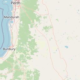
Use this park location map to pinpoint Hilliger National Park in Australia, understand its exact geographic position, and read its mapped placement within the surrounding landscape more clearly.

Pigeon | © OpenStreetMap contributors

Location context for Hilliger National Park

Western Australia
Park atlas

Trace the regional geography and discover other protected areas surrounding Hilliger National Park.

Discover Surrounding National Parks and Protected Landscapes Near Hilliger National Park
Explore other significant national parks and protected areas located geographically near Hilliger National Park in Western Australia's South West region. Compare diverse forest conservation landscapes, map their spatial relationships, and understand the broader network of protected land in the Jarrah Forest bioregion.
National parkAustralia

Milyeannup National Park: Explore its Protected Landscape and Geographic Atlas Context

Discover the mapped terrain and boundaries of this Australian national park.

Milyeannup National Park offers a unique focus for atlas-based geographic exploration. This entry details the park's identity as a protected area, highlighting its landscape context and mapped geographic features within Australia. Use this resource to understand its role in the national park system and its specific place within the broader landscape.

Area
186.92 km²
Established
2004
Scope
Terrestrial
Forest
Mostly forested
National parkWestern Australia

Easter National Park: Protected Jarrah Forest Landscape Atlas

Explore its mapped terrain and regional geography.

Easter National Park serves as a protected national park in Western Australia, preserving crucial jarrah forest ecosystems within the Warren bioregion. As part of the Southwest Australia biodiversity hotspot, it contributes to a contiguous block of protected land safeguarding the region's distinctive woodland and forest communities. Users can explore its mapped boundaries and understand its role within the broader South West Australian geography, offering a detailed look at a representative forest reserve.

Area
29.85 km²
Established
2004
IUCN
II
Relief
Lowland
National park

Wiltshire-Butler National Park: Mapped Jarrah Forest Landscape in Western Australia

Explore protected boundaries and regional geographic context

Wiltshire-Butler National Park stands as a protected natural area celebrated for its representation of Western Australia's iconic jarrah forest ecosystems. This National Park, created in 2004, offers rich opportunities for atlas-based discovery, focusing on its distinct landscape character, mapped park boundaries, and its geographical placement within the broader South West region. Understanding its terrain and conservation significance provides valuable insight into the protected lands of the Jarrah Forest bioregion.

Area
116.45 km²
Established
2004
IUCN
II
Relief
Highland
National parkWestern Australia

Blackwood River National Park: Protected Area in Western Australia's Geography

Explore mapped boundaries and natural terrain.

Blackwood River National Park is a key protected area within the vast geographic expanse of Western Australia. This park's designation as a national park underscores its importance for conservation and landscape preservation. Users can explore its precisely mapped boundaries to understand its footprint and its contribution to the regional natural landscape context, offering a grounded perspective on protected lands within Australia.

Area
204.75 km²
Established
2004
IUCN
II
Relief
Upland
National parkWestern Australia

Greater Beedelup National Park: Western Australia's National Park Landscape

Discover Protected Areas and Regional Geography

Explore Greater Beedelup National Park, a key protected landscape within Western Australia. This national park offers a focus for understanding mapped natural features and the regional distribution of conservation areas. It serves as a vital point for atlas-based discovery, providing structured insights into the park's geographic setting and its identity as a protected natural area.

Area
17.83 km²
Established
1915
IUCN
II
Relief
Upland
National parkWestern Australia

Scott National Park National Park: Mapped Protected Landscape in Western Australia

Geographic Context and Natural Terrain Discovery

Scott National Park serves as a significant protected area within the diverse geography of Western Australia. This national park provides a focal point for understanding regional landscape patterns and mapped natural features. Explore its role as a protected land, offering insight into the state's broad natural heritage and supporting detailed geographic discovery for atlas enthusiasts.

Area
32.73 km²
Established
1959
IUCN
II
Relief
Lowland
National parkWestern Australia

Warren National Park: A Protected Landscape of Ancient Karri Forests in Western Australia

Explore mapped forest boundaries and river geography.

Warren National Park offers an unparalleled glimpse into the grandeur of old-growth karri forests, showcasing some of Western Australia's most towering trees. Situated in the South West region, this national park protects a vital tract of temperate forest ecosystem, characterized by rolling terrain and the scenic Warren River. Its mapped landscape and protected-area status highlight the critical importance of preserving these magnificent natural environments for atlas-based geographic discovery.

Area
29.81 km²
Established
1977
IUCN
II
Scope
Terrestrial
National park

Greater Hawke National Park: Mapped Boundaries of Old Growth Forest Landscape

Explore the protected forest and regional geography.

Greater Hawke National Park offers a significant atlas exploration opportunity for understanding Australia's protected forest ecosystems. This national park preserves critical old growth stands of karri and jarrah trees, showcasing the unique landscape of the Warren bioregion. Its Class A reserve status and adjacency to D'Entrecasteaux National Park highlight its importance as a conservation corridor within the South West of Western Australia. Users can examine the park's geographic setting and its protected-area identity.

Area
140.04 km²
Established
2004
Climate
Mediterranean
Access
Moderate access

Common questions about visiting, size, designation, and location context for Hilliger National Park

Hilliger National Park FAQs for park facts, access, geography, and protected area context
Find quick answers about Hilliger National Park, including protected-area facts, park geography, trail and visitor context, and how the park fits into its surrounding country and regional landscape.
MoriAtlas Explorer

Continue Your Protected Areas Search Across the Global Atlas

Deepen your exploration by continuing the structured search for national parks and protected areas worldwide. Utilize the comprehensive filtering capabilities to compare different conservation landscapes and refine your understanding of global park geography. Discover more about the distribution and characteristics of protected natural areas.

Global natural geography
Hilliger National Park: Protected Landscape & Atlas Entry | MoriAtlas