

Mori Atlas logo
National parkMilyeannup National Park

Discover the mapped boundaries and regional context of this Australian national park.

Milyeannup National Park: Australia's Protected Landscape and Geographic Atlas Entry

Milyeannup National Park stands as a key protected area within Australia's diverse geography. This page serves as your authoritative entry point for exploring the park's protected landscape identity and its precise location within the broader Australian atlas. Understand the mapped boundaries and natural terrain that define this significant national park, providing a foundation for geographic discovery.

Jarrah ForestSouth West Western AustraliaNational ParkForest ConservationBiodiversity HotspotProtected Area

Milyeannup National Park

National park

Park overview

Structured park overview, official facts, and landscape profile for Milyeannup National Park

Milyeannup National Park park facts, protected area profile, and essential visitor context
Review the core facts for Milyeannup National Park, including designation, size, terrain, visitor scale, habitats, and operating context in one park-focused overview.

About Milyeannup National Park

Milyeannup National Park is located in the South West land division of Western Australia, an area renowned for its Mediterranean climate, scenic landscapes, and ecological diversity. The park occupies a substantial tract of land within the Jarrah Forest bioregion, protecting forest ecosystems that characterize much of southwestern Australia. The establishment of this national park in 2004 represented a significant conservation achievement for Western Australia, creating a protected area that complements the adjacent Hilliger National Park. Together, these protected areas form a larger conservation landscape in the Nannup region, supporting the preservation of forest habitats that are endemic to this part of Australia. The park provides protection for landscapes that have cultural and ecological significance within the broader South West region.

Quick facts and research context for Milyeannup National Park

Milyeannup National Park occupies 18,692 hectares (46,190 acres) of land in the South West of Western Australia. The park was formally declared on 30 November 2004 as Class A Reserve No. 47669, making it one of nine national parks established in Western Australia on that date. It is administered by the Department of Biodiversity, Conservation and Attractions and is located in the Shire of Nannup, bordering Hilliger National Park to the north. The park sits within the Jarrah Forest bioregion, a recognized ecological zone characterized by its extensive hardwood forest cover.

Park context

Deeper park guide and search-rich context for Milyeannup National Park

Milyeannup National Park history, landscape, wildlife, and travel context
Explore Milyeannup National Park through its history, landscape character, ecosystems, wildlife, conservation priorities, cultural context, and seasonal travel timing in a structured park guide built for atlas discovery and search intent.

Why Milyeannup National Park stands out

Milyeannup National Park is best known for its protection of jarrah forest landscapes in Western Australia's South West. The park preserves a significant portion of the Jarrah Forest bioregion, an ecological area that supports distinctive southwestern Australian flora and represents one of the state's major forest types. The park's establishment in 2004 marked an important addition to Western Australia's protected area network, safeguarding forest ecosystems that were historically subject to logging and other land uses.

Milyeannup National Park history and protected-area timeline

Milyeannup National Park was created on 30 November 2004 as part of a major expansion of Western Australia's national park system. On this date, nine new national parks were proclaimed across the state, representing a significant commitment to conservation and protected area establishment. The park was declared as Class A Reserve No. 47669, providing the highest level of protection under Western Australian land management legislation. The park's establishment followed decades of forest management in the region and represented a shift toward recognizing the conservation value of intact forest landscapes. The creation of the park was administered through the Department of Biodiversity, Conservation and Attractions, which continues to manage the protected area.

Milyeannup National Park landscape and geographic character

The landscape of Milyeannup National Park is characterized by the rolling terrain typical of the Jarrah Forest bioregion in southwestern Australia. The park is dominated by jarrah and marri trees, the two principal eucalypt species that define much of the South West's forest landscape. The terrain features the undulating hills and valleys common to this region, with soils derived from laterite and granite parent materials that support the dense forest cover. The forest canopy creates a characteristic landscape of tall hardwood trees with a diverse understory of shrubs and groundcovers adapted to the Mediterranean climate of the region.

Milyeannup National Park ecosystems, habitats, and plant life

Milyeannup National Park lies within the Jarrah Forest bioregion, one of the recognized biodiversity hotspots of southwestern Australia. This bioregion is characterized by its extensive jarrah and marri forest ecosystems, which support a diversity of plant and animal species found nowhere else in the world. The park protects forest habitats that form part of the Southwest Australia Floristic Region, a global biodiversity hotspot recognized for its high degree of endemism. The vegetation communities within the park reflect the broader ecological character of the South West, with forest structures that have evolved under the region's seasonal rainfall patterns and Mediterranean climate.

Milyeannup National Park wildlife and species highlights

The Jarrah Forest bioregion supports a range of wildlife species adapted to southwestern Australia's forest environments. The park's forest habitats provide shelter and foraging resources for various bird species, mammals, and reptiles that inhabit the region. While specific species documentation is limited in available sources, the broader jarrah forest ecosystem is known to support diverse fauna including marsupials such as possums and bandicoots, various reptile species, and an array of birdlife. The connectivity provided by the park, together with adjacent Hilliger National Park, supports wildlife movement through the regional landscape.

Milyeannup National Park conservation status and protection priorities

Milyeannup National Park represents an important conservation outcome for Western Australia's South West region. The park protects representative examples of jarrah forest ecosystems that were historically subject to timber harvesting and other extractive uses. The establishment of the park as a Class A reserve provides strong statutory protection for the forest landscapes and associated biodiversity. The park contributes to the regional network of protected areas in the South West, working in conjunction with adjacent Hilliger National Park to form a larger conservation landscape. The protection of the Jarrah Forest bioregion is significant given the global recognition of Southwest Australia as a biodiversity hotspot.

Milyeannup National Park cultural meaning and human context

Milyeannup National Park is situated within the traditional lands of Aboriginal peoples of the South West region of Western Australia. The Nannup area and surrounding jarrah forest landscapes have been inhabited by Indigenous Australians for thousands of years, with the forest environments providing cultural and subsistence resources for local Aboriginal communities. While specific cultural documentation is limited in available sources, the broader South West region contains significant Aboriginal heritage values associated with forest and woodland landscapes.

Top sights and standout views in Milyeannup National Park

The park's primary highlight is its protection of extensive jarrah forest landscapes in the South West of Western Australia, an ecosystem that defines much of the region's character. The park's establishment in 2004 as part of a major conservation initiative represents a significant milestone in Western Australian protected area history. The park's adjacency to Hilliger National Park creates a larger protected landscape that enhances conservation outcomes for the region. The location within the Jarrah Forest bioregion places this park within one of Australia's recognized biodiversity hotspots.

Best time to visit Milyeannup National Park

The optimal time to visit Milyeannup National Park is during the cooler months from late autumn through to early spring, which corresponds to the period from May to October in the Southern Hemisphere. This timeframe aligns with the Mediterranean climate of the South West region, where summer months can be hot and dry. Visiting during the cooler season provides more comfortable conditions for exploring the forest landscapes and allows visitors to experience the park's natural environments during their most active period. The winter and spring months also bring increased wildflower activity in the understory, adding botanical interest to a visit.
Park location guide

Geography guide, regional context, and park location map for Milyeannup National Park

Milyeannup National Park park geography, regions, and map view in Australia
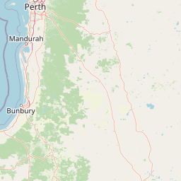
Understand where Milyeannup National Park sits in Australia through a broader geographic reading of the surrounding landscape, nearby location context, and its mapped position within the national park landscape.

How Milyeannup National Park fits into Australia

Australia is a constitutional monarchy and federal parliamentary democracy comprising six states and ten territories. With a population of nearly 28 million, it is one of the world's most urbanised countries, with most people concentrated on the eastern seaboard. The country has a high Human Development Index and is known for its cultural diversity, ancient Aboriginal heritage, and unique wildlife.

Wider geography shaping Milyeannup National Park in Australia

Australia occupies the entire Australian continent, the island of Tasmania, and numerous smaller islands. It is the world's flattest and driest inhabited continent, featuring vast deserts in the interior (the Outback), tropical rainforests along the eastern coast, and a coastline bordering the Indian and Pacific Oceans.

Map view of Milyeannup National Park

Use this park location map to pinpoint Milyeannup National Park in Australia, understand its exact geographic position, and read its mapped placement within the surrounding landscape more clearly.

Pigeon | © OpenStreetMap contributors

Location context for Milyeannup National Park

Western Australia
Park atlas

Explore regional park geography and adjacent protected areas surrounding Milyeannup National Park, comparing Jarrah Forest landscapes in Western Australia.

Explore National Parks and Protected Areas Near Milyeannup National Park in Western Australia
Browse other national parks and protected areas across Western Australia, including adjacent reserves and the wider Jarrah Forest landscapes near Milyeannup National Park. This allows for direct geographic comparison, tracing the protected area network and understanding its regional context in southwestern Australia.
National park

Hilliger National Park: Western Australian Protected Jarrah Forest and Memorial Landscape

Mapped boundaries of a vital national park in the South West region.

Hilliger National Park stands as a testament to forest conservation in Western Australia's South West. This 16,962-hectare national park, established in 2004, protects representative old-growth jarrah forest ecosystems and honors a significant firefighting legacy. Explore its terrain and its geographic placement within a broader network of protected lands, offering a concrete example of conservation strategy in the region. The park's mapped area contributes valuable data to the understanding of regional natural landscapes.

Area
169.62 km²
Established
2004
Climate
Temperate
Scope
Terrestrial
National parkWestern Australia

Easter National Park: Protected Jarrah Forest Landscape Atlas

Explore its mapped terrain and regional geography.

Easter National Park serves as a protected national park in Western Australia, preserving crucial jarrah forest ecosystems within the Warren bioregion. As part of the Southwest Australia biodiversity hotspot, it contributes to a contiguous block of protected land safeguarding the region's distinctive woodland and forest communities. Users can explore its mapped boundaries and understand its role within the broader South West Australian geography, offering a detailed look at a representative forest reserve.

Area
29.85 km²
Established
2004
IUCN
II
Relief
Lowland
National park

Wiltshire-Butler National Park: Mapped Jarrah Forest Landscape in Western Australia

Explore protected boundaries and regional geographic context

Wiltshire-Butler National Park stands as a protected natural area celebrated for its representation of Western Australia's iconic jarrah forest ecosystems. This National Park, created in 2004, offers rich opportunities for atlas-based discovery, focusing on its distinct landscape character, mapped park boundaries, and its geographical placement within the broader South West region. Understanding its terrain and conservation significance provides valuable insight into the protected lands of the Jarrah Forest bioregion.

Area
116.45 km²
Established
2004
IUCN
II
Relief
Highland
National parkWestern Australia

Blackwood River National Park: Protected Area in Western Australia's Geography

Explore mapped boundaries and natural terrain.

Blackwood River National Park is a key protected area within the vast geographic expanse of Western Australia. This park's designation as a national park underscores its importance for conservation and landscape preservation. Users can explore its precisely mapped boundaries to understand its footprint and its contribution to the regional natural landscape context, offering a grounded perspective on protected lands within Australia.

Area
204.75 km²
Established
2004
IUCN
II
Relief
Upland
National parkWestern Australia

Greater Beedelup National Park: Western Australia's National Park Landscape

Discover Protected Areas and Regional Geography

Explore Greater Beedelup National Park, a key protected landscape within Western Australia. This national park offers a focus for understanding mapped natural features and the regional distribution of conservation areas. It serves as a vital point for atlas-based discovery, providing structured insights into the park's geographic setting and its identity as a protected natural area.

Area
17.83 km²
Established
1915
IUCN
II
Relief
Upland
National park

Dalgarup National Park: Protected Forest Landscape and Regional Geographic Context in Western Australia

Mapped boundaries of protected areas within the Jarrah Forest bioregion.

Dalgarup National Park serves as a crucial protected area, safeguarding the characteristic jarrah-marri forest ecosystems of southwestern Australia. Located within the Jarrah Forest and Warren bioregions, its terrain reflects the undulating topography and Mediterranean climate prevalent in the South West land division. This national park offers a unique opportunity to explore mapped natural landscapes and understand the conservation efforts within a region historically shaped by forest ecology and development.

Area
23.77 km²
Established
2004
Scope
Terrestrial
Water
Minor water
National parkWestern Australia

Scott National Park National Park: Mapped Protected Landscape in Western Australia

Geographic Context and Natural Terrain Discovery

Scott National Park serves as a significant protected area within the diverse geography of Western Australia. This national park provides a focal point for understanding regional landscape patterns and mapped natural features. Explore its role as a protected land, offering insight into the state's broad natural heritage and supporting detailed geographic discovery for atlas enthusiasts.

Area
32.73 km²
Established
1959
IUCN
II
Relief
Lowland
National parkWestern Australia

Whicher National Park: Exploring Western Australia's Protected Landscape Geography

A national park with distinct mapped boundaries and natural terrain.

Delve into the geographic profile of Whicher National Park, a designated national park situated within the vast landscapes of Western Australia. This entry provides an atlas-focused view of the park's protected land identity, its position within the regional geography, and the characteristics of its mapped natural terrain. Understand the park's specific role as a protected area and its contribution to the broader natural landscape context of Western Australia.

Established
2019
IUCN
II
Relief
Upland
Climate
Mediterranean

Common questions about visiting, size, designation, and location context for Milyeannup National Park

Milyeannup National Park FAQs for park facts, access, geography, and protected area context
Find quick answers about Milyeannup National Park, including protected-area facts, park geography, trail and visitor context, and how the park fits into its surrounding country and regional landscape.
MoriAtlas Explorer

Continue Your Protected Areas Search Across the Global Atlas

Deepen your exploration by continuing the structured search for national parks and protected areas worldwide. Utilize the comprehensive filtering capabilities to compare different conservation landscapes and refine your understanding of global park geography. Discover more about the distribution and characteristics of protected natural areas.

Global natural geography