

Mori Atlas logo
National parkWhicher National Park

Explore the mapped boundaries and natural terrain of this key national park.

Whicher National Park: Mapping Protected Landscape Geography in Western Australia

Whicher National Park stands as a protected landscape entity within the expansive geography of Western Australia. This page focuses on the park's distinct national park designation and its role in understanding regional natural terrain and mapped protected areas. Discover the geographic context of Whicher National Park, offering a foundation for atlas-style exploration of its boundaries and surrounding landscapes.

National ParkWestern AustraliaJarrah ForestSouth West AustraliaProtected AreaWhicher Range

Whicher National Park

National park

Park overview

Structured park overview, official facts, and landscape profile for Whicher National Park

Whicher National Park park facts, protected area profile, and essential visitor context
Review the core facts for Whicher National Park, including designation, size, terrain, visitor scale, habitats, and operating context in one park-focused overview.

About Whicher National Park

Whicher National Park occupies a distinctive position in the protected area estate of Western Australia, preserving the rugged interior of the Whicher Range within the state's South West. The range itself represents a north-south oriented ridge of ancient Precambrian rocks that form some of the oldest geological formations in the region. The park was formally established in 2019 following years of advocacy for enhanced conservation protection of the Whicher Range's unique landscapes and biodiversity. The Whicher Range functions as a climatic divide, influencing precipitation patterns and vegetation distribution across the surrounding lowlands. Visitors to the area encounter a landscape characterized by steep terrain, exposed rock outcrops, and forest-covered slopes that support a distinctive suite of plant and animal species. The park's establishment reflects growing recognition of the ecological significance of Western Australia's South West forests and the need to protect representative examples of the region's diverse bioregions.

Quick facts and research context for Whicher National Park

Whicher National Park lies in the South West of Western Australia, approximately 270 kilometers south of Perth. The park occupies the higher elevations of the Whicher Range, a Precambrian granite and gneiss mountain system that forms a prominent ridge separating the Blackwood Plateau from the coastal plain. The park falls within both the Jarrah Forest and Warren bioregions, two of Western Australia's most biodiverse forest ecosystems. The protected Petrophile shrub, a genus of prostrate shrubs adapted to sandy and rocky substrates, is a notable botanical feature. The Margaret River originates within the park's boundaries, making this protected area important for downstream water quality and catchment protection.

Park context

Deeper park guide and search-rich context for Whicher National Park

Whicher National Park history, landscape, wildlife, and travel context
Explore Whicher National Park through its history, landscape character, ecosystems, wildlife, conservation priorities, cultural context, and seasonal travel timing in a structured park guide built for atlas discovery and search intent.

Why Whicher National Park stands out

Whicher National Park is best known for protecting the headwaters and scenic landscapes of the Margaret River, one of Western Australia's most famous waterways. The park encompasses the mountainous heart of the Whicher Range, preserving a landscape of rugged ridgelines and forested slopes that contrast sharply with the surrounding jarrah and marri woodlands of the lower slopes. The protection of Petrophile populations represents a significant botanical conservation value, as this genus comprises several species endemic to the Southwest Australian Floristic Region, a global biodiversity hotspot. The park also serves as a critical catchment area, with its hydrological function supporting the broader Margaret River wine region's agricultural economy and environmental health.

Whicher National Park history and protected-area timeline

Whicher National Park was officially declared in 2019, representing the culmination of conservation efforts that began in the early 2000s. Prior to national park designation, the Whicher Range area had been managed as a state forest with limited formal protection, despite its ecological significance and importance as a catchment for the Margaret River. Environmental organizations and local conservation groups advocated for elevated protection status, emphasizing the area's unique biodiversity, its role as a water source, and the threat posed by changing land use pressures in the surrounding region. The declaration of Whicher National Park added approximately 25,000 hectares to Western Australia's national park system, consolidating protection for the Whicher Range's most significant natural values. Management of the park falls to the Western Australia Department of Parks and Wildlife, which oversees visitor access, conservation programs, and fire management within the reserve.

Whicher National Park landscape and geographic character

The landscape of Whicher National Park is defined by the Whicher Range, a mountainous ridge that rises abruptly from the surrounding jarrah forest plains. The range reaches elevations exceeding 400 meters above sea level, with the highest peaks presenting panoramic views across the South West landscape. The underlying geology consists of ancient Precambrian granite and gneiss, among the oldest rock formations in Western Australia. These ancient rocks have been subjected to millions of years of weathering, resulting in deeply weathered soils and laterite capped ridges. The terrain is characterized by steep slopes, rocky outcrops, and narrow valleys that channel rainfall into the headwaters of the Margaret River and its tributaries. The park's forests transition from tall jarrah-marri woodland on the lower slopes to more open woodland and heath communities on the exposed ridgelines.

Whicher National Park ecosystems, habitats, and plant life

Whicher National Park lies at the intersection of two major bioregions: the Jarrah Forest to the north and the Warren bioregion to the south. This transitional position contributes to the park's ecological diversity, as species from both regions overlap in the Whicher Range. The vegetation communities within the park reflect this biogeographic complexity, with jarrah and marri trees dominating the taller woodland formations, while proteaceous shrubs including various Petrophile species characterize the more open heath communities on rocky sites. The Southwest Australian Floristic Region, to which this park belongs, is recognized as one of the world's biodiversity hotspots, supporting an extraordinary concentration of endemic plant species. The park's function as a catchment area for the Margaret River adds aquatic and riparian values to its terrestrial biodiversity.

Whicher National Park wildlife and species highlights

The wildlife of Whicher National Park reflects the diverse forest and woodland habitats found throughout the South West of Western Australia. Mammals common to the area include western grey kangaroos, common ringtail possums, and various small marsupials adapted to forest life. The jarrah and marri woodlands provide important habitat for diverse bird communities, including honeyeaters, parrots, and woodland birds that depend on the old-growth tree hollows for nesting. Reptiles including skinks, dragons, and snakes occupy the rocky outcrops and ground-layer habitats. The riparian zones along the Margaret River and its tributaries support species adapted to aquatic and streamside environments. While specific species inventories for Whicher National Park remain limited, the broader South West forest bioregions are known for high levels of reptile and invertebrate endemism.

Whicher National Park conservation status and protection priorities

The establishment of Whicher National Park represents a significant conservation outcome for the South West of Western Australia. The park protects representative examples of Jarrah Forest and Warren bioregion landscapes that had previously lacked formal protection at the national park level. The protection of Petrophile populations is particularly significant, as several species within this genus are endemic to the Southwest Australian Floristic Region and face varying levels of threat from habitat fragmentation and changing fire regimes. The park's role in protecting the headwaters of the Margaret River adds a critical conservation value, as the river's downstream reaches support agricultural operations, community water supplies, and important estuarine and marine ecosystems. The Whicher Range also serves as a biological corridor, connecting fragmented remnants of native vegetation and facilitating species movement across the agricultural landscape.

Whicher National Park cultural meaning and human context

The Whicher Range and surrounding South West forests have been home to Aboriginal peoples for tens of thousands of years, though specific cultural heritage information for the park area is limited in the available sources. The Noongar peoples are the traditional owners of much of the South West of Western Australia, and the landscape contains cultural values that may not be documented in publicly available material. The region more broadly is known for the extensive logging history that shaped much of the jarrah forest, with the establishment of Whicher National Park representing a shift toward conservation-oriented management that preserves the area's natural values rather than extracting its timber resources.

Top sights and standout views in Whicher National Park

Whicher National Park protects one of the Southwest Australian Floristic Region's most significant mountainous wilderness areas, preserving the source waters of the Margaret River and critical habitat for endemic plant species including protected Petrophile shrubs. The park's rugged ridgelines, ancient geological formations, and diverse forest communities offer a wilderness experience distinct from the more accessible coastal and vineyard landscapes of the broader Margaret River region. The recent establishment of the park in 2019 marks it as one of Western Australia's newest national parks, with ongoing development of visitor facilities and management programs. The Whicher Range's function as a hydrological divide and water source adds ecological significance beyond the park's boundaries.
Park location guide

Geography guide, regional context, and park location map for Whicher National Park

Whicher National Park park geography, regions, and map view in Australia
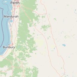
Understand where Whicher National Park sits in Australia through a broader geographic reading of the surrounding landscape, nearby location context, and its mapped position within the national park landscape.

How Whicher National Park fits into Australia

Australia is a constitutional monarchy and federal parliamentary democracy comprising six states and ten territories. With a population of nearly 28 million, it is one of the world's most urbanised countries, with most people concentrated on the eastern seaboard. The country has a high Human Development Index and is known for its cultural diversity, ancient Aboriginal heritage, and unique wildlife.

Wider geography shaping Whicher National Park in Australia

Australia occupies the entire Australian continent, the island of Tasmania, and numerous smaller islands. It is the world's flattest and driest inhabited continent, featuring vast deserts in the interior (the Outback), tropical rainforests along the eastern coast, and a coastline bordering the Indian and Pacific Oceans.

Map view of Whicher National Park

Use this park location map to pinpoint Whicher National Park in Australia, understand its exact geographic position, and read its mapped placement within the surrounding landscape more clearly.

Pigeon | © OpenStreetMap contributors

Location context for Whicher National Park

Western Australia
Park atlas

Trace Regional Park Geography: Compare Protected Landscapes and Explore Conservation Areas Across Western Australia's South West

Explore Nearby National Parks and Protected Areas Beyond Whicher National Park, Western Australia
Discover additional national parks and protected areas across Western Australia's South West, extending your exploration beyond Whicher National Park to surrounding jarrah forests and the Whicher Range. Compare diverse protected landscapes, trace regional park geography, and understand conservation efforts within this significant biodiversity hotspot.
National park

Tuart Forest National Park: Discover Australia's Most Significant Pure Tuart Woodland Landscape

Explore the unique limestone terrain and vast eucalyptus geography.

Tuart Forest National Park in Western Australia is a critical protected area dedicated to preserving the world's largest remaining pure tuart forest. This unique ecosystem, found on coastal limestone soils, features some of the most immense Eucalyptus gomphocephala trees globally. The park's geography is characterized by its undulating limestone terrain, supporting a vital habitat for endangered wildlife like the Western Ringtail Possum, offering unparalleled insight into Australia's rare woodland environments.

Area
20.49 km²
Established
1987
IUCN
II
Relief
Lowland
National park

Wiltshire-Butler National Park: Mapped Jarrah Forest Landscape in Western Australia

Explore protected boundaries and regional geographic context

Wiltshire-Butler National Park stands as a protected natural area celebrated for its representation of Western Australia's iconic jarrah forest ecosystems. This National Park, created in 2004, offers rich opportunities for atlas-based discovery, focusing on its distinct landscape character, mapped park boundaries, and its geographical placement within the broader South West region. Understanding its terrain and conservation significance provides valuable insight into the protected lands of the Jarrah Forest bioregion.

Area
116.45 km²
Established
2004
IUCN
II
Relief
Highland
National park

Dalgarup National Park: Protected Forest Landscape and Regional Geographic Context in Western Australia

Mapped boundaries of protected areas within the Jarrah Forest bioregion.

Dalgarup National Park serves as a crucial protected area, safeguarding the characteristic jarrah-marri forest ecosystems of southwestern Australia. Located within the Jarrah Forest and Warren bioregions, its terrain reflects the undulating topography and Mediterranean climate prevalent in the South West land division. This national park offers a unique opportunity to explore mapped natural landscapes and understand the conservation efforts within a region historically shaped by forest ecology and development.

Area
23.77 km²
Established
2004
Scope
Terrestrial
Water
Minor water
National parkWestern Australia

Blackwood River National Park: Protected Area in Western Australia's Geography

Explore mapped boundaries and natural terrain.

Blackwood River National Park is a key protected area within the vast geographic expanse of Western Australia. This park's designation as a national park underscores its importance for conservation and landscape preservation. Users can explore its precisely mapped boundaries to understand its footprint and its contribution to the regional natural landscape context, offering a grounded perspective on protected lands within Australia.

Area
204.75 km²
Established
2004
IUCN
II
Relief
Upland
National parkAustralia

Milyeannup National Park: Explore its Protected Landscape and Geographic Atlas Context

Discover the mapped terrain and boundaries of this Australian national park.

Milyeannup National Park offers a unique focus for atlas-based geographic exploration. This entry details the park's identity as a protected area, highlighting its landscape context and mapped geographic features within Australia. Use this resource to understand its role in the national park system and its specific place within the broader landscape.

Area
186.92 km²
Established
2004
Scope
Terrestrial
Forest
Mostly forested
National parkWestern Australia

Easter National Park: Protected Jarrah Forest Landscape Atlas

Explore its mapped terrain and regional geography.

Easter National Park serves as a protected national park in Western Australia, preserving crucial jarrah forest ecosystems within the Warren bioregion. As part of the Southwest Australia biodiversity hotspot, it contributes to a contiguous block of protected land safeguarding the region's distinctive woodland and forest communities. Users can explore its mapped boundaries and understand its role within the broader South West Australian geography, offering a detailed look at a representative forest reserve.

Area
29.85 km²
Established
2004
IUCN
II
Relief
Lowland
National park

Hilliger National Park: Western Australian Protected Jarrah Forest and Memorial Landscape

Mapped boundaries of a vital national park in the South West region.

Hilliger National Park stands as a testament to forest conservation in Western Australia's South West. This 16,962-hectare national park, established in 2004, protects representative old-growth jarrah forest ecosystems and honors a significant firefighting legacy. Explore its terrain and its geographic placement within a broader network of protected lands, offering a concrete example of conservation strategy in the region. The park's mapped area contributes valuable data to the understanding of regional natural landscapes.

Area
169.62 km²
Established
2004
Climate
Temperate
Scope
Terrestrial
National parkWestern Australia

Wellington National Park: Protected Jarrah Forest & Collie River Landscape

Explore the mapped boundaries and regional geography.

Wellington National Park offers a deep dive into Western Australia's protected landscapes, characterized by extensive old-growth jarrah forests and the scenic Collie River valley. This national park provides a vital study of the region's unique geography, mapped terrain, and ecological significance within the Yilgarn craton. Understand the park's protected area identity and its place in the wider natural context of Western Australia through its detailed landscape features.

Area
170 km²
Established
2000
IUCN
II
Visitors
212K annual

Common questions about visiting, size, designation, and location context for Whicher National Park

Whicher National Park FAQs for park facts, access, geography, and protected area context
Find quick answers about Whicher National Park, including protected-area facts, park geography, trail and visitor context, and how the park fits into its surrounding country and regional landscape.
MoriAtlas Explorer

Continue Your Protected Areas Search Across the Global Atlas

Deepen your exploration by continuing the structured search for national parks and protected areas worldwide. Utilize the comprehensive filtering capabilities to compare different conservation landscapes and refine your understanding of global park geography. Discover more about the distribution and characteristics of protected natural areas.

Global natural geography