

Mori Atlas logo
National parkHoragolla National Park

Discover the geographic boundaries and atlas context of Horagolla National Park in Western Province.

Horagolla National Park: Sri Lanka's Protected National Park and Mapped Landscape

Horagolla National Park stands as a protected national park within Sri Lanka's Western Province, offering a specific geographic focus for atlas-based discovery. This entry provides essential details about its mapped boundaries and its role as a designated protected landscape. Explore the regional geography and natural terrain context that defines this significant Sri Lankan park entity for a deeper understanding of its place within the broader natural atlas.

Evergreen ForestBirdwatchingUrban ParkWestern Province Sri LankaLowland RainforestEndemic Species

Horagolla National Park

National park

Park overview

Structured park overview, official facts, and landscape profile for Horagolla National Park

Horagolla National Park park facts, protected area profile, and essential visitor context
Review the core facts for Horagolla National Park, including designation, size, terrain, visitor scale, habitats, and operating context in one park-focused overview.

About Horagolla National Park

Horagolla National Park represents a distinctive protected area within Sri Lanka's Western Province, occupying a modest 33-hectare footprint that nonetheless harbors remarkable biodiversity. The park's location near Nittambuwa places it within the administrative heart of Sri Lanka's most densely populated province, yet the area retains a wilderness character that belies its urban proximity. The forest ecosystem classification as low-country evergreen forest places it within one of Sri Lanka's most threatened habitat types, as lowland rainforests have been extensively cleared for agriculture and development across the island. Horagolla's protection thus serves not only as a biodiversity reservoir but as a living demonstration of sustainable forest management within an urban context. The park's connection to the Horagolla Walauwa, the historic home of the influential Bandaranaike family, adds a dimension of cultural heritage to the natural landscape.

Quick facts and research context for Horagolla National Park

Horagolla National Park covers 33 hectares of low-country evergreen forest in Sri Lanka's Western Province. Originally protected as a wildlife sanctuary in 1973, it achieved national park status in 2004. The park features humus-rich soils and maintains a consistently warm temperature throughout the year. Located near Nittambuwa and approximately 40 kilometers from Colombo, it serves as an important green space within one of Sri Lanka's most densely populated regions. The Department of Wildlife Conservation manages the park, which is notable for its diverse flora including several endemic tree species.

Park context

Deeper park guide and search-rich context for Horagolla National Park

Horagolla National Park history, landscape, wildlife, and travel context
Explore Horagolla National Park through its history, landscape character, ecosystems, wildlife, conservation priorities, cultural context, and seasonal travel timing in a structured park guide built for atlas discovery and search intent.

Why Horagolla National Park stands out

Horagolla National Park is best known as Sri Lanka's only urban forest sanctuary in the Western Province, representing a rare remnant of low-country evergreen forest in a heavily populated region. The park is renowned for its dense stands of Dipterocarpus zeylanicus (hora trees), which give the area its name and form a significant component of the forest canopy. It is also recognized as a birdwatching destination with 68 documented bird species, including several endemic Sri Lankan species such as the Sri Lanka grey hornbill and Sri Lanka hanging parrot. The park's proximity to Colombo makes it an accessible natural escape for residents of the capital region.

Horagolla National Park history and protected-area timeline

The area comprising Horagolla National Park was originally declared a wildlife sanctuary on September 5, 1973, recognizing the ecological significance of the remaining forest cover in this portion of the Western Province. At the time of designation, the primary motivation was the preservation of the rich biodiversity present in this low-country evergreen forest, which was already recognized as supporting numerous species of flora and fauna. The park remained under wildlife sanctuary status for over three decades, during which time conservation efforts focused on protecting the existing forest ecosystem and its resident wildlife populations. On June 24, 2004, Horagolla was elevated to national park status, reflecting both the success of earlier conservation measures and the increased recognition of the area's value as an ecological and recreational resource. This elevation also acknowledged the park's growing importance as an accessible nature destination for residents of the Colombo metropolitan area.

Horagolla National Park landscape and geographic character

The physical landscape of Horagolla National Park is characterized by low-country evergreen forest terrain typical of Sri Lanka's southwestern lowland regions. The terrain is generally flat to gently undulating, with the forest canopy reaching heights characteristic of mature tropical rainforest. The soil composition is notably rich in humus, reflecting the dense organic matter accumulation from decades of leaf litter and forest floor decomposition. This soil fertility supports the luxuriant vegetation growth that defines the park's appearance. Throughout the year, the park experiences consistently hot temperatures, typical of Sri Lanka's low-country climate, with rainfall patterns that maintain the evergreen character of the forest. The park's compact size encompasses a complete forest ecosystem, from the emergent canopy of the tallest trees through the understory layers to the forest floor, creating a vertically stratified habitat complex.

Horagolla National Park ecosystems, habitats, and plant life

The ecological character of Horagolla National Park is defined by its classification as a low-country evergreen forest, a habitat type once widespread across Sri Lanka's lowlands but now largely restricted to remnant patches. The forest supports an impressive diversity of tree species, with the dominant Dipterocarpus zeylanicus (hora) giving the park its name and forming a significant portion of the upper canopy. Other prominent tree species include Canarium zeylanicum (kekuna), Dillenia retusa (godapara), Caryota urens (kitul), Pericopsis mooniana (nedun), and Mangifera zeylanica (atamba). The park also contains numerous lianas, including Entada rheedei (pus-wel), which contribute to the dense vegetation structure. The presence of species such as Gmelina arborea, Filicium decipiens, mahogany, teak, and golden shower tree indicates the park's ecological complexity. The humus-rich soil and warm, consistent temperatures create conditions favorable for year-round biological activity.

Horagolla National Park wildlife and species highlights

Horagolla National Park supports a noteworthy diversity of wildlife despite its relatively small area. The mammal population includes several notable species: the fishing cat, a wetland-adapted predator; the Sri Lankan spotted chevrotain, one of the island's smallest ungulates; the golden jackal; and the grizzled giant squirrel, a species that thrives in forested habitats. The park has achieved recognition as a birdwatching destination, with 68 bird species documented within its boundaries. The avian community includes both resident species and migrants, with parakeets, black-crested bulbul, barbets, and Asian koel among the most commonly observed. Endemic species such as the Sri Lanka grey hornbill, Sri Lanka hanging parrot, Layard's parakeet, and Oriental dwarf kingfisher add significant conservation value to the bird checklist. The butterfly fauna includes the rare clipper, Ceylon birdwing, and blue Mormon, while reptile populations feature pythons and cobras. Tortoises and other threatened species are also present, highlighting the park's conservation significance.

Horagolla National Park conservation status and protection priorities

Horagolla National Park serves important conservation functions within Sri Lanka's protected area network, particularly as a representative example of low-country evergreen forest in the heavily populated Western Province. The park's elevation from wildlife sanctuary to national park status in 2004 reflected institutional recognition of its ecological value and the success of earlier protective measures. As the only urban park in the Western Province, Horagolla provides critical habitat for species that would otherwise be displaced by agricultural expansion and urban development. The presence of numerous endemic species, including several threatened animals, underscores the park's role in biodiversity preservation. The conservation of this forest remnant also provides ecosystem services for the surrounding region, including watershed protection and microclimate regulation.

Horagolla National Park cultural meaning and human context

Horagolla National Park is situated in proximity to Horagolla Walauwa, the historic ancestral home of the Bandaranaike family, one of Sri Lanka's most influential political dynasties. This connection to national political history adds a layer of cultural significance to the park beyond its ecological value. The Walauwa, a traditional Sri Lankan estate house, represents a form of rural landed heritage that once characterized the landscape of the Western Province. While the park itself is primarily valued for its natural resources, this historical association provides context for understanding the area's land use history and its place in regional heritage. The park's accessibility from Colombo also reflects the historical pattern of estate ownership and agricultural settlement that shaped the Western Province's development.

Top sights and standout views in Horagolla National Park

Horagolla National Park stands out as a compact but ecologically rich protected area that offers accessible forest exploration within Sri Lanka's most populated region. The park's defining feature is its dense low-country evergreen forest dominated by hora trees, providing a rare glimpse of habitat types that once covered much of Sri Lanka's lowlands. The birdlife, with 68 documented species including several endemics, makes the park particularly valuable for birdwatching enthusiasts. The presence of mammals including fishing cat and grizzled giant squirrel adds to the wildlife viewing opportunities. The park's status as the only urban park in the Western Province gives it unique accessibility for nature observation by Colombo residents and visitors seeking a quick wilderness escape.

Best time to visit Horagolla National Park

Horagolla National Park can be visited throughout the year given its location in Sri Lanka's low-country region, where temperatures remain consistently warm. The best time for birdwatching is typically during the early morning hours when avian activity peaks, and the dry season months generally offer more comfortable conditions for forest exploration. Visitors interested in maximizing wildlife encounters should consider the periods when water sources in the area are most accessible, drawing animals to predictable locations. The park's compact size allows for thorough exploration in a relatively short visit, making it suitable for day trips from Colombo.

Park location guide

Geography guide, regional context, and park location map for Horagolla National Park

Horagolla National Park park geography, regions, and map view in Sri Lanka
Understand where Horagolla National Park sits in Sri Lanka through a broader geographic reading of the surrounding landscape, nearby location context, and its mapped position within the national park landscape.

How Horagolla National Park fits into Sri Lanka

Sri Lanka is a tropical island nation in South Asia with a recorded history spanning over 3,000 years. Formerly known as Ceylon, it became independent in 1948 and adopted its current constitutional name in 1972. The country features diverse geography ranging from coastal plains to mountainous highlands and maintains a population exceeding 22 million.

Wider geography shaping Horagolla National Park in Sri Lanka

Sri Lanka is an island nation in the Indian Ocean, positioned southwest of the Bay of Bengal. It is separated from India by the Gulf of Mannar and Palk Strait to the northwest. The island has a pear-like shape with diverse terrain including coastal plains, central highlands, and river valleys.

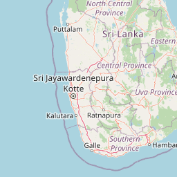
Map view of Horagolla National Park

Use this park location map to pinpoint Horagolla National Park in Sri Lanka, understand its exact geographic position, and read its mapped placement within the surrounding landscape more clearly.

Pigeon | © OpenStreetMap contributors

Location context for Horagolla National Park

Western Province
Park atlas

Trace the regional park geography and browse other protected landscapes that share similar characteristics or geographic proximity to Horagolla National Park.

Explore National Parks and Protected Areas Near Horagolla National Park, Sri Lanka's Urban Forest Sanctuary
Continue your geographic exploration beyond Horagolla National Park to discover other protected areas and national parks within Sri Lanka's Western Province and surrounding regions. Utilize this park-to-park comparison to trace shared low-country evergreen forest ecosystems, examine birdwatching destinations, and understand regional protected landscape patterns through an atlas lens.
National parkCentral Province

Galways Land National Park: A Protected Landscape within Central Province, Sri Lanka

Explore the mapped geography and protected area context of this national park.

Galways Land National Park is a designated national park within the Central Province of Sri Lanka, offering a distinct focus for geographic exploration. This entry provides specific details on its protected landscape characteristics and its place within the regional atlas. Users can examine the mapped boundaries and understand the natural terrain that defines this conservation area. Discover the unique geographic identity of Galways Land National Park and its contribution to the protected areas network.

Area
0.27 km²
Established
2006
IUCN
II
Relief
Mountain
National parkCentral Province

Horton Plains National Park: A Protected Landscape within Sri Lanka's Central Province

Explore its mapped geographic boundaries and park identity.

Delve into the geographic specifics of Horton Plains National Park, a designated national park located in the Central Province of Sri Lanka. This entry provides detailed insights into its protected area status, mapped landscape features, and regional geographic context. Understand how this park contributes to the atlas of protected lands and offers a distinct point for landscape exploration.

Area
31.6 km²
Established
1988
IUCN
II
Relief
Mountain
National parkSouthern Province

Hikkaduwa National Park: Protected Area Identity and Geographic Context in Southern Province

Explore mapped boundaries and regional landscape features.

Hikkaduwa National Park stands as a vital national park, offering rich geographic details for atlas exploration. This page focuses on its protected landscape identity within Sri Lanka's Southern Province, providing insights into its mapped terrain and regional context. Understand the park's specific place in the landscape, ideal for users seeking structured geographic data and detailed map-based insights into protected natural areas.

Area
1.016 km²
Established
2002
IUCN
II
Climate
Tropical
National parkCentral Province

Wasgamuwa National Park: A National Park in Central Province for Geographic Exploration

Mapped protected boundaries and landscape context.

Wasgamuwa National Park is a significant national park located in Sri Lanka's Central Province, offering valuable data for atlas exploration and geographic understanding. This protected area's mapped boundaries and regional setting within Central Province provide essential context for researchers and explorers focused on conservation landscapes. Discover the park's unique geographic identity and its contribution to the regional atlas, highlighting its role as a structured natural landscape.

Area
393.22 km²
Established
1984
IUCN
II
Relief
Upland
National parkSri Lanka

Udawalawe National Park: National Park Protected Landscape and Geographic Atlas

Explore Sri Lanka's mapped natural terrain and park boundaries.

Gain a comprehensive atlas-level understanding of Udawalawe National Park, a key protected landscape in Sri Lanka. This entry focuses on the park's distinct geographic identity, its mapped boundaries, and its significance as a protected area within the island's diverse natural terrain. Explore how this national park contributes to the regional geography and provides structured insights for landscape discovery.

Area
308.21 km²
Established
1972
IUCN
II
Visitors
188.4K annual
National parkNorth Central Province

Minneriya National Park: A Protected National Park in North Central Province

Explore mapped boundaries and regional landscape context.

Minneriya National Park is a designated national park offering unique protected landscape exploration within Sri Lanka's North Central Province. This entry provides structured data crucial for understanding the park's geographic features, its defined boundaries, and its significance as a protected area. Dive into the atlas context that illuminates the natural terrain and regional setting of Minneriya National Park.

Area
88.894 km²
Established
1997
IUCN
II
Relief
Mixed relief
National parkNorth Central Province

Angammedilla National Park: Protecting the Watershed for Parakrama Samudra in North Central Province

Mapped dry evergreen forests and mountainous terrain boundaries.

Angammedilla National Park is a national park in Sri Lanka's North Central Province renowned for its pivotal role in safeguarding the drainage basin for the large Parakrama Samudra reservoir. This protected landscape features significant dry evergreen forest ecosystems and mountainous terrain, contributing to the region's ecological stability and wildlife habitats. Its establishment highlights a commitment to preserving vital natural resources and understanding the complex interplay between protected areas and regional geography.

Area
75.29 km²
Established
2006
IUCN
II
Relief
Mountain
National parkNorth Central Province

Flood Plains National Park: Sri Lanka's Vital Wetland and Elephant Corridor

Mapping the geography of its unique villus system and Mahaweli River flood plain.

Flood Plains National Park stands as a paramount protected wetland ecosystem in Sri Lanka's North Central Province, critically important as an elephant corridor along the Mahaweli River. The park's landscape is defined by its unique villus system, shallow swampy depressions that support extraordinary biodiversity and serve as vital feeding grounds for Asian elephants and migratory waterfowl. Understanding the mapped park boundaries and its regional geographic context reveals its significance in landscape-level conservation efforts within the Mahaweli basin.

Area
173.5 km²
Established
1984
IUCN
II
Relief
Lowland

Common questions about visiting, size, designation, and location context for Horagolla National Park

Horagolla National Park FAQs for park facts, access, geography, and protected area context
Find quick answers about Horagolla National Park, including protected-area facts, park geography, trail and visitor context, and how the park fits into its surrounding country and regional landscape.
MoriAtlas Explorer

Continue Your Protected Areas Search Across the Global Atlas

Deepen your exploration by continuing the structured search for national parks and protected areas worldwide. Utilize the comprehensive filtering capabilities to compare different conservation landscapes and refine your understanding of global park geography. Discover more about the distribution and characteristics of protected natural areas.

Global natural geography