

Mori Atlas logo
National parkWasgamuwa National Park

Discover the mapped protected area boundaries and natural landscape context.

Wasgamuwa National Park: A National Park within Sri Lanka's Central Province Geography

Wasgamuwa National Park stands as a key protected area within the Central Province of Sri Lanka, offering a distinct focus for geographic exploration and atlas discovery. This national park serves as a vital entity for understanding the region's conservation landscapes and mapped terrain. Engage with Wasgamuwa National Park to trace its protected boundaries and appreciate its place within the broader Sri Lankan geography, providing structured insight for any atlas-focused study.

Dry Zone ForestsElephant HabitatImportant Bird AreaSri Lankan EndemicsAncient Irrigation HeritageRiverine Ecosystems

Wasgamuwa National Park

National park

Park overview

Structured park overview, official facts, and landscape profile for Wasgamuwa National Park

Wasgamuwa National Park park facts, protected area profile, and essential visitor context
Review the core facts for Wasgamuwa National Park, including designation, size, terrain, visitor scale, habitats, and operating context in one park-focused overview.

About Wasgamuwa National Park

Wasgamuwa National Park occupies a significant position in Sri Lanka's protected area network as one of the country's premier dry-zone conservation landscapes. The park's creation in 1984 was directly tied to the Mahaweli Development Project, one of South Asia's largest hydroelectric and irrigation schemes, which displaced substantial wildlife populations from their natural habitats. Designated initially as a nature reserve in 1938 and later upgraded to a strict nature reserve in the early 1970s, the area finally achieved national park status to ensure robust protection for its ecological and cultural resources. The park encompasses a complex mosaic of forest types including primary dry evergreen forest, secondary woodland, riparian corridors, and extensive grassland patches surrounding ancient tanks. These habitats support remarkable biodiversity, with the park ranking among Sri Lanka's most botanically and zoologically rich protected areas. The Amban Ganga river traverses the park, providing critical water resources for both wildlife and the historic irrigation systems that have shaped the landscape for centuries.

Quick facts and research context for Wasgamuwa National Park

Wasgamuwa National Park is located in the dry zone of Sri Lanka, approximately 225 kilometers from Colombo in the Matale and Polonnaruwa Districts. The park was established in 1984 to protect wildlife displaced by the Mahaweli Development Project and covers roughly 39,322 hectares. The highest point is Sudu Kanda (White Mountain) at 470 meters. The climate is warm year-round with average temperatures around 28°C, receiving rainfall primarily during the northeastern monsoon season from October through January. The park features dry evergreen forest ecosystems, riverine forests along the Amban Ganga, and extensive grasslands surrounding historic irrigation tanks.

Park context

Deeper park guide and search-rich context for Wasgamuwa National Park

Wasgamuwa National Park history, landscape, wildlife, and travel context
Explore Wasgamuwa National Park through its history, landscape character, ecosystems, wildlife, conservation priorities, cultural context, and seasonal travel timing in a structured park guide built for atlas discovery and search intent.

Why Wasgamuwa National Park stands out

Wasgamuwa National Park is best known for its large populations of Sri Lankan elephants, which can be observed in herds of up to 150 individuals roaming the park's diverse habitats. The park is also distinguished by its remarkable concentration of endemic wildlife, including several mammal, bird, reptile, and amphibian species found nowhere else on Earth. The park's cultural landscape is equally remarkable, containing the ruins of ancient irrigation systems constructed during the reign of King Parākramabāhu I, including tanks, canals, and the historic Chulangani chaitya. The name Wasgamuwa itself derives from the Sinhala words for sloth bear (walas) and wood (gamuwa), reflecting the park's rich ecological heritage.

Wasgamuwa National Park history and protected-area timeline

The history of Wasgamuwa National Park extends far beyond its 1984 establishment as a protected area, intertwining with Sri Lanka's ancient hydraulic civilization. The park contains the ruins of several historic irrigation tanks including Malagamuwa, Wilmitiya, and Dasthota, as well as the Kalinga Yoda Ela canal, all constructed during the reign of King Parākramabāhu I in the 12th century. These engineering works once channeled water from the Minipe anicut's left bank canal to the great Parakrama Samudra reservoir, with the Amban Ganga serving as the conduit through what is now Wasgamuwa. The park also holds historical significance as the battleground where King Ellalan and King Dutthagamani fought their legendary conflict, with the grasslands known as Yudangana Pitiya and Kandauru Pitiya marking specific locations associated with this ancient confrontation. The impressive ruins of the Chulangani chaitya, a Buddhist stupa built by King Mahanaga, still stand within the park, its circumference exceeding that of the famous Ruwanwelisaya in Anuradhapura. Artifacts recovered from the chaitya, including a bowl used by King Sri Vikrama Rajasinha and bronze statues, are now preserved at the Yudangana vihara.

Wasgamuwa National Park landscape and geographic character

The physical landscape of Wasgamuwa National Park presents a distinctive dry-zone terrain characterized by undulating terrain rising to the park's highest point at Sudu Kanda (White Mountain), which reaches 470 meters above sea level. The underlying geology features quartz and marble deposits that influence soil composition throughout the park. The terrain supports a diverse array of habitats ranging from dense dry evergreen forest canopies to open grasslands dotted with ancient irrigation reservoirs. The park's drainage system centers on the Amban Ganga, which flows through the protected area and sustains riverine forest corridors that provide critical habitat connectivity. Grassland patches, many associated with the historic tank systems, create open savanna-like areas that are particularly important for elephant movement and grazing. The landscape's visual character combines the untamed appearance of natural forest with the subtle but enduring marks of ancient human modification through irrigation infrastructure.

Wasgamuwa National Park ecosystems, habitats, and plant life

The ecological character of Wasgamuwa is defined by Sri Lanka's dry-zone dry evergreen forest ecosystem, which represents a distinctive ecological formation found primarily in the island's northern and central regions. The park contains over 150 recorded floral species, representing one of the highest biodiversity concentrations among Sri Lanka's protected areas. The forest structure exhibits multiple distinct layers, with dominant tree species including Chloroxylon swietenia, Manilkara hexandra, Elaeodendron glaucum, Pterospermum canescens, Diospyros ebenum, Vitex altissima, Drypetes sepiaria, and Berrya cordifolia comprising the emergent canopy. The understory features additional species such as Polyalthia korinti, Diplodiscus verrucosus, Limonia acidissima, and Cassia roxburghii. Two plants of particular economic value, Cryptocoryne walkeri and Munronia pumila, have been documented within the park. The riverine forests along the Amban Ganga and the grasslands surrounding historic tanks create habitat mosaics that support exceptional faunal diversity. The climate pattern, with annual rainfall between 1650 and 2100 millimeters received primarily during the October-to-January monsoon period, shapes the seasonal dynamics of these ecosystems.

Wasgamuwa National Park wildlife and species highlights

Wasgamuwa National Park supports exceptional wildlife diversity, with 23 mammal species, 143 bird species, 17 reptile species, eight amphibian species, 17 fish species, and approximately 50 butterfly species recorded within its boundaries. The park's mammalian flagship is the Sri Lankan elephant, with herds of up to 150 individuals regularly observed throughout the protected area. The marsh elephant (Elephas maximus vil-aliya) specifically inhabits the Mahaweli River zone. Both primate species found in the park, the purple-faced langur and the toque macaque, are endemic to Sri Lanka. The park provides habitat for several rare and elusive species including the Sri Lanka leopard and sloth bear, while the golden palm civet represents another endemic mammal present in small numbers. The avifauna includes eight endemic species such as the red-faced malkoha, Sri Lanka junglefowl, and Sri Lanka spurfowl, alongside aquatic birds like peafowl, painted storks, black-headed ibis, and Eurasian spoonbills. Reptile diversity includes water monitors, mugger crocodiles, and several endemic skink and lizard species, while the aquatic habitats support endemic fish including Garra ceylonensis and combtail.

Wasgamuwa National Park conservation status and protection priorities

Wasgamuwa National Park faces several significant conservation challenges despite its protected status. Livestock intrusion from neighboring villages represents a persistent threat, as domestic cattle are released into the park's grasslands, potentially transmitting diseases to wild populations and competing for grazing resources and water access. These cattle also cause physical damage to the park's perimeter electric fencing. Illegal logging remains a difficult problem to address, with timber extraction threatening forest integrity. Human-wildlife conflict is particularly acute regarding elephants, which regularly damage property in surrounding villages and have caused fatal attacks. A proposed elephant transit home within the park aims to address some of these conflicts. Environmental concerns have been raised regarding proposed resettlement of displaced communities from the Moragahakanda reservoir construction, as this could intensify elephant-human confrontation. The park's designation as an Important Bird Area underscores its broader conservation significance for global avifauna populations.

Wasgamuwa National Park cultural meaning and human context

The cultural landscape of Wasgamuwa reflects over a millennium of human interaction with the terrain, beginning with the ancient irrigation systems constructed during Sri Lanka's hydraulic civilization. The ruins of tanks and canals built under King Parākramabāhu I demonstrate sophisticated water management engineering that transformed the dry-zone landscape and created the reservoir and grassland habitats that now support diverse wildlife. The park's association with the legendary battle between King Ellalan and King Dutthagamani connects the landscape to foundational episodes in Sri Lankan history, with specific locations within the park preserving this cultural memory. The Chulangani chaitya represents Buddhist heritage embedded within the protected area, its impressive scale reflecting the spiritual significance this location held in ancient times. The park name itself derives from Sinhala, preserving linguistic heritage in its very designation.

Top sights and standout views in Wasgamuwa National Park

Wasgamuwa National Park offers exceptional opportunities to observe Sri Lankan elephants in their natural dry-zone habitat, with large herds regularly visible throughout the park's forest and grassland mosaics. The park's biodiversity is remarkable for its concentration of endemic species across multiple taxonomic groups, from mammals and birds to reptiles, amphibians, fish, and insects. The ancient cultural landscape, featuring 12th-century irrigation infrastructure and Buddhist monuments, provides a unique historical dimension rarely found in other Sri Lankan protected areas. The combination of dry evergreen forest, riverine corridors, and tank-associated grasslands creates scenic variety that supports both wildlife viewing and ecological appreciation. The park's relative accessibility from major population centers makes it a practical destination for experiencing Sri Lanka's dry-zone wilderness and wildlife.

Best time to visit Wasgamuwa National Park

The optimal period to visit Wasgamuwa National Park coincides with the dry season extending from July through September, when water sources become concentrated around remaining water bodies and wildlife congregates near the Amban Ganga and historic tanks. The latter months of the year, particularly November and December, also offer favorable conditions as the park emerges from the northeastern monsoon rains and vegetation becomes less dense, improving wildlife visibility. The monsoon season from October to January brings substantial rainfall that can affect access and create lush but denser vegetation cover. The hot dry season from March to May brings the warmest conditions but also increases wildlife activity around remaining water sources. Temperature remains consistently warm throughout the year, averaging around 28°C, with the dry months generally considered most productive for wildlife observation.
Park location guide

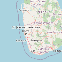
Geography guide, regional context, and park location map for Wasgamuwa National Park

Wasgamuwa National Park park geography, regions, and map view in Sri Lanka
Understand where Wasgamuwa National Park sits in Sri Lanka through a broader geographic reading of the surrounding landscape, nearby location context, and its mapped position within the national park landscape.

How Wasgamuwa National Park fits into Sri Lanka

Sri Lanka is a tropical island nation in South Asia with a recorded history spanning over 3,000 years. Formerly known as Ceylon, it became independent in 1948 and adopted its current constitutional name in 1972. The country features diverse geography ranging from coastal plains to mountainous highlands and maintains a population exceeding 22 million.

Wider geography shaping Wasgamuwa National Park in Sri Lanka

Sri Lanka is an island nation in the Indian Ocean, positioned southwest of the Bay of Bengal. It is separated from India by the Gulf of Mannar and Palk Strait to the northwest. The island has a pear-like shape with diverse terrain including coastal plains, central highlands, and river valleys.

Map view of Wasgamuwa National Park

Use this park location map to pinpoint Wasgamuwa National Park in Sri Lanka, understand its exact geographic position, and read its mapped placement within the surrounding landscape more clearly.

Pigeon | © OpenStreetMap contributors

Location context for Wasgamuwa National Park

Central ProvinceNorth Central Province
Park atlas

Trace the regional park geography of central Sri Lanka, comparing protected areas adjacent to Wasgamuwa National Park.

Discover Nearby National Parks and Protected Areas Beyond Wasgamuwa National Park
After exploring Wasgamuwa National Park, browse other national parks and protected areas situated in the broader region of central Sri Lanka. Compare their unique landscapes, key protected species, and geographic characteristics to deepen your understanding of Sri Lanka's conservation efforts.
National parkNorth Central Province

Angammedilla National Park: Protecting the Watershed for Parakrama Samudra in North Central Province

Mapped dry evergreen forests and mountainous terrain boundaries.

Angammedilla National Park is a national park in Sri Lanka's North Central Province renowned for its pivotal role in safeguarding the drainage basin for the large Parakrama Samudra reservoir. This protected landscape features significant dry evergreen forest ecosystems and mountainous terrain, contributing to the region's ecological stability and wildlife habitats. Its establishment highlights a commitment to preserving vital natural resources and understanding the complex interplay between protected areas and regional geography.

Area
75.29 km²
Established
2006
IUCN
II
Relief
Mountain
National parkNorth Central Province

Flood Plains National Park: Sri Lanka's Vital Wetland and Elephant Corridor

Mapping the geography of its unique villus system and Mahaweli River flood plain.

Flood Plains National Park stands as a paramount protected wetland ecosystem in Sri Lanka's North Central Province, critically important as an elephant corridor along the Mahaweli River. The park's landscape is defined by its unique villus system, shallow swampy depressions that support extraordinary biodiversity and serve as vital feeding grounds for Asian elephants and migratory waterfowl. Understanding the mapped park boundaries and its regional geographic context reveals its significance in landscape-level conservation efforts within the Mahaweli basin.

Area
173.5 km²
Established
1984
IUCN
II
Relief
Lowland
National parkNorth Central Province

Minneriya National Park: A Protected National Park in North Central Province

Explore mapped boundaries and regional landscape context.

Minneriya National Park is a designated national park offering unique protected landscape exploration within Sri Lanka's North Central Province. This entry provides structured data crucial for understanding the park's geographic features, its defined boundaries, and its significance as a protected area. Dive into the atlas context that illuminates the natural terrain and regional setting of Minneriya National Park.

Area
88.894 km²
Established
1997
IUCN
II
Relief
Mixed relief
National parkNorth Central Province

Kaudulla National Park: Sri Lanka's Protected National Park Geography

Mapped landscape and regional context for Kaudulla National Park.

Kaudulla National Park stands as a protected national park offering valuable geographic insights for atlas explorers. This page details the park's location within the North Central Province, providing context on its mapped terrain and protected area status. Users can delve into the structured geographic data associated with Kaudulla National Park, enhancing their understanding of Sri Lanka's conservation landscapes.

Area
69 km²
Established
2002
IUCN
II
Visitors
10K annual
National parkSri Lanka

Somawathiya National Park: A Sri Lankan National Park Protected Landscape

Explore its mapped boundaries and regional geography.

Delve into the geographic identity of Somawathiya National Park, a designated national park within Sri Lanka. This entry provides atlas-level insights into its protected landscape, mapped terrain, and the specific natural area context it offers. Understand Somawathiya National Park's place in the Sri Lankan geography for structured discovery, focusing on its protected status and mapped features without travel logistics.

Area
376.455 km²
Established
1986
IUCN
II
Relief
Lowland
National parkUva Province

Gal Oya National Park: Protected Landscape and Reservoir Geography in Uva Province

Explore savannah grasslands, elephant populations, and mapped terrain.

Gal Oya National Park presents a unique protected landscape within Uva Province, Sri Lanka. This national park is defined by its broad savannah grasslands, known as thalawa, interspersed with forested hills and the vast Senanayake Samudraya reservoir. Its varied topography, from lowlands to mountain peaks, offers a rich canvas for geographic exploration and understanding protected-area dynamics. The park's consistent visibility of elephant populations across these diverse terrains makes it a key site for wildlife observation within Sri Lanka's atlas of natural heritage.

Area
259 km²
Established
1954
IUCN
II
Relief
Mountain
National parkCentral Province

Galways Land National Park: A Protected Landscape within Central Province, Sri Lanka

Explore the mapped geography and protected area context of this national park.

Galways Land National Park is a designated national park within the Central Province of Sri Lanka, offering a distinct focus for geographic exploration. This entry provides specific details on its protected landscape characteristics and its place within the regional atlas. Users can examine the mapped boundaries and understand the natural terrain that defines this conservation area. Discover the unique geographic identity of Galways Land National Park and its contribution to the protected areas network.

Area
0.27 km²
Established
2006
IUCN
II
Relief
Mountain
National parkNorth Central Province

Horowpathana National Park: Protected Landscape within North Central Province's Dry Zone

Explore its mapped boundaries and vital wildlife habitat.

Horowpathana National Park is a designated national park in Sri Lanka's North Central Province, covering 2,570 hectares of dry zone forest. Established to protect critical habitats for endangered species like the Sri Lankan elephant and leopard, it plays a vital role in regional wildlife conservation and managing human-wildlife conflict. Its landscape is characterized by dry forest ecosystems situated near the Tawalamham Hammillewa reservoir system, presenting a unique environmental context within the broader mapped geography of the island.

Area
25.7 km²
Established
2011
IUCN
II
Climate
Tropical

Common questions about visiting, size, designation, and location context for Wasgamuwa National Park

Wasgamuwa National Park FAQs for park facts, access, geography, and protected area context
Find quick answers about Wasgamuwa National Park, including protected-area facts, park geography, trail and visitor context, and how the park fits into its surrounding country and regional landscape.
MoriAtlas Explorer

Continue Your Protected Areas Search Across the Global Atlas

Deepen your exploration by continuing the structured search for national parks and protected areas worldwide. Utilize the comprehensive filtering capabilities to compare different conservation landscapes and refine your understanding of global park geography. Discover more about the distribution and characteristics of protected natural areas.

Global natural geography