

Mori Atlas logo
National parkSomawathiya National Park

Explore the mapped geography and protected land boundaries of this Sri Lankan natural area.

Somawathiya National Park: Sri Lanka's National Park Protected Landscape

Somawathiya National Park stands as a significant protected landscape within the geography of Sri Lanka. This page offers an atlas-oriented view of Somawathiya National Park, focusing on its identity as a national park and its role within the country's broader protected areas network. Discover the park's geographic context, mapped terrain features, and how it contributes to Sri Lanka's natural landscape mosaic for detailed exploration and understanding.

wetland reserveelephant habitatbirdwatching destinationflood plain ecosystemBuddhist pilgrimage siteriver delta protected area

Somawathiya National Park

National park

Park overview

Structured park overview, official facts, and landscape profile for Somawathiya National Park

Somawathiya National Park park facts, protected area profile, and essential visitor context
Review the core facts for Somawathiya National Park, including designation, size, terrain, visitor scale, habitats, and operating context in one park-focused overview.

About Somawathiya National Park

Somawathiya National Park occupies a unique position in Sri Lanka's protected area network as a wetland-dominated landscape within the broader Mahaweli River basin. The park's terrain is characterized by its low-lying flood plain setting, where the Mahaweli River's deltaic environment has created a complex mosaic of grasslands, seasonal water bodies, and riparian forests. The central flood plain contains numerous old river channels and approximately 20 villus, which are shallow depressions that fill with water during seasonal flooding and support distinctive ecological communities. The park's location at the confluence of the Mahaweli's two major distributaries places it at a critical ecological junction between riverine and coastal wetland systems. This positioning, combined with the fertile alluvial soils deposited by annual flooding, creates conditions that support extraordinarily high biological productivity and diverse habitat types within a relatively compact area.

Quick facts and research context for Somawathiya National Park

Somawathiya National Park is located in Sri Lanka's North Central and Eastern Provinces, approximately 266 kilometers northeast of Colombo. The park occupies the flood plain delta of the Mahaweli River, Sri Lanka's longest river, where it forks into the main channel flowing north to Koddiyar Bay and the lesser Verugal Oya flowing northeast to the sea. The landscape features approximately 20 villus, which are shallow water-filled basins interspersed among grasslands. The park was established under the Mahaweli River development project, one of four national parks created as part of this comprehensive water resource and conservation initiative. It is managed by Sri Lanka's Department of Wildlife Conservation.

Park context

Deeper park guide and search-rich context for Somawathiya National Park

Somawathiya National Park history, landscape, wildlife, and travel context
Explore Somawathiya National Park through its history, landscape character, ecosystems, wildlife, conservation priorities, cultural context, and seasonal travel timing in a structured park guide built for atlas discovery and search intent.

Why Somawathiya National Park stands out

Somawathiya National Park is best known for its significant Asian elephant population, with an estimated 400 elephants inhabiting the protected area and surrounding regions, making it an important elephant conservation site in Sri Lanka. The park is also renowned for its exceptional wetland avifauna, with approximately 75 migratory bird species wintering in the marshes and flood plains. The presence of the sacred Somawathiya Chaitya, a Buddhist stupa containing a relic of the Buddha's tooth, adds religious and cultural significance that draws both pilgrims and tourists. The villus wetland system, with its seasonal flooding cycles and fertile alluvial soils, creates a highly productive habitat supporting diverse flora and fauna.

Somawathiya National Park history and protected-area timeline

The Somawathiya area holds considerable historical and religious significance, centered around the Somawathiya Chaitya stupa located on the left bank of the Mahaweli River. This ancient stupa was named after Princess Somawathi, the sister of King Kavan Tissa of Ruhuna and wife of Prince Abhaya. According to historical accounts, Prince Abhaya commissioned the stupa to enshrine a relic of the tooth of the Buddha that had come into the possession of the Buddhist monk Arahat Mahinda. The stupa continues to be an important pilgrimage site, with visitors reporting supernatural phenomena including beams of light and unusual apparitions. The modern protected area was established through a phased process, initially designated as a wildlife sanctuary on August 9, 1966, before being elevated to national park status on September 2, 1986. The park was created as part of the Mahaweli River development project, a large-scale initiative that also established Maduru Oya, Wasgamuwa, and Flood Plains national parks. Somawathiya was later incorporated into the Mahaweli Environment Project to improve management and protection.

Somawathiya National Park landscape and geographic character

The physical landscape of Somawathiya National Park is defined by its position within the Mahaweli River's deltaic flood plain system. The terrain is predominantly flat and low-lying, with elevation changes measured in mere meters across the entire park. The central ecological feature is the network of approximately 20 villus, which are shallow, water-filled basins scattered throughout the grassy plains. These villus form the heart of the park's wetland system, with their hydrology directly tied to the Mahaweli River's seasonal flooding patterns. The river itself splits into two main branches within the park boundaries: the main Mahaweli channel flowing northward toward Koddiyar Bay, and the lesser Verugal Oya flowing northeast toward the sea. The surrounding landscape includes remnants of riparian forest and transitional areas where wetland gives way to drier forest types. The alluvial soils underlying the entire flood plain are highly fertile, supporting lush vegetation even in areas that experience seasonal inundation.

Somawathiya National Park ecosystems, habitats, and plant life

The ecological character of Somawathiya is fundamentally shaped by its wetland environment and the seasonal flooding cycle of the Mahaweli River. The villus support distinctive zonation of plant communities based on water depth and inundation duration. Near the edges where flooding is temporary and shallow, creeping grasses like Cynodon dactylon dominate. Moving toward the center of these basins, where water persists longer, truly hydrophytic species including Alternanthera sessilis, various Polygonum species, Ludwigia repens, Ipomoea aquatica, Monochoria hastata, and Scirpus grossus become prevalent. The most widespread grasses across the wetland include Hygroryza aristata, Brachiaria mutica, Echinochloa colonum, Paspalum vaginatum, and Digitaria longiflora. In deeper water, floating aquatic plants occur alongside Nelumbo nucifera, while deeper still, an association of Nymphaea stellata and the submerged aquatic plant Ceratophyllum demersum prevails. The forest areas, particularly in the northern region of the park, contain tree species such as Drypetes sepiaria, Berrya cordifolia, Diospyros ovalifolia, and Manilkara hexandra. The combination of wetland and forest habitats creates a mosaic that supports high biodiversity.

Somawathiya National Park wildlife and species highlights

Somawathiya National Park supports remarkable wildlife diversity, with particular significance for large mammals and waterfowl. The Asian elephant population represents one of the park's most notable ecological assets, with estimates of approximately 400 individuals in the protected area and surrounding landscape, though some surveys suggest smaller numbers in recent decades. The mammalian community includes several carnivore species such as the golden jackal, fishing cat, rusty-spotted cat, and leopard, alongside ungulates including sambar deer, wild boar, and water buffalo. Smaller mammals include the Indian crested porcupine and black-naped hare. The wetland marshes are extraordinarily important for birdlife, hosting approximately 75 migratory species during the winter months. Migratory waterfowl include garganey, marsh sandpiper, wood sandpiper, pintail snipe, whiskered tern, and black-tailed godwit. Resident birds include the painted stork, Asian openbill, various egret species, pheasant-tailed jacana, purple swamphen, black-headed ibis, and black-winged stork. Forest-dwelling birds include the crimson-fronted barbet, Indian peafowl, Malabar pied hornbill, Sri Lanka junglefowl, and golden-fronted leafbird.

Somawathiya National Park conservation status and protection priorities

Somawathiya National Park, together with the adjacent Flood Plains National Park, plays a critical role in protecting the wetland ecosystem of the Mahaweli River flood plains. These protected areas are excessively important for both migratory and resident waterfowl, serving as key habitat within the broader East Asian-Australasian flyway. The villus system possesses high moisture retention and carrying capacity, allowing for relatively rapid ecological regeneration when human disturbance is removed. However, the park has faced significant conservation challenges, particularly from deforestation for agriculture, illegal logging, and grazing by cattle from tobacco cultivators who annually enter the area. Deforestation intensified significantly from the mid-1970s onward. An overall systems plan exists for protected areas within the Mahaweli Region, and the area's incorporation into the Mahaweli Environment Project represented an important step toward addressing previous management deficits. The park's contiguous relationship with Flood Plains National Park and connection to Hurulu Forest Reserve, part of which is designated as a biosphere reserve, creates opportunities for landscape-level conservation approaches.

Somawathiya National Park cultural meaning and human context

Somawathiya National Park contains the Somawathiya Chaitya, a Buddhist stupa of considerable religious significance that predates the modern protected area by centuries. This ancient religious structure is named after Princess Somawathi, whose historical connection to the site links the landscape to the early regional history of the Ruhuna kingdom. The stupa is believed to contain a relic of the tooth of the Buddha, a highly sacred object in Buddhist tradition that was entrusted to the monk Arahat Mahinda. The convergence of religious heritage and natural conservation creates a unique cultural landscape where spiritual pilgrimage and wildlife preservation coexist. The area attracts visitors seeking both the natural wonders of the wetland ecosystem and the spiritual ambiance of the ancient sacred site. The continued religious use of the stupa while maintaining the surrounding area as protected habitat demonstrates how cultural practices and conservation objectives can be reconciled within Sri Lanka's national park framework.

Top sights and standout views in Somawathiya National Park

Somawathiya National Park stands out as one of Sri Lanka's most important wetland conservation areas, combining significant elephant populations with exceptional bird diversity in a landscape shaped by the Mahaweli River's seasonal flooding. The park's network of villus creates a dynamic wetland environment that supports both resident wildlife and substantial migratory bird populations. The presence of the ancient Somawathiya Chaitya adds cultural depth, making the park a destination that bridges ecological and spiritual tourism. Its position within the Mahaweli development project links it to a broader vision of integrated water resource management and conservation. The park's contiguous connection to Flood Plains National Park and proximity to Hurulu Forest Reserve create a larger protected area complex that supports landscape-scale ecological processes. The combination of accessible wildlife viewing in a wetland setting and the cultural resonance of an ancient Buddhist pilgrimage site gives Somawathiya a distinctive identity among Sri Lanka's national parks.

Best time to visit Somawathiya National Park

The best time to visit Somawathiya National Park coincides with the dry season from May to September, when water levels in the villus decrease and wildlife becomes more concentrated around remaining water sources, facilitating observation. The park can be visited year-round, though the wet season from October to April brings flooding that disperses wildlife across a larger area and can limit access to some regions. Migratory birds are most abundant during the northern hemisphere winter months, typically arriving by November and departing by March or April. The period immediately after the monsoon season, in late October and November, often provides optimal conditions with good wildlife viewing opportunities while landscapes remain lush from recent rains. Visitors interested in the cultural and religious aspects of the Somawathiya Chaitya should be aware that pilgrimage activity may be higher during important Buddhist observances.
Park location guide

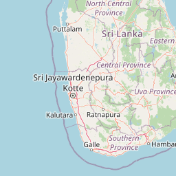
Geography guide, regional context, and park location map for Somawathiya National Park

Somawathiya National Park park geography, regions, and map view in Sri Lanka
Understand where Somawathiya National Park sits in Sri Lanka through a broader geographic reading of the surrounding landscape, nearby location context, and its mapped position within the national park landscape.

How Somawathiya National Park fits into Sri Lanka

Sri Lanka is a tropical island nation in South Asia with a recorded history spanning over 3,000 years. Formerly known as Ceylon, it became independent in 1948 and adopted its current constitutional name in 1972. The country features diverse geography ranging from coastal plains to mountainous highlands and maintains a population exceeding 22 million.

Wider geography shaping Somawathiya National Park in Sri Lanka

Sri Lanka is an island nation in the Indian Ocean, positioned southwest of the Bay of Bengal. It is separated from India by the Gulf of Mannar and Palk Strait to the northwest. The island has a pear-like shape with diverse terrain including coastal plains, central highlands, and river valleys.

Map view of Somawathiya National Park

Use this park location map to pinpoint Somawathiya National Park in Sri Lanka, understand its exact geographic position, and read its mapped placement within the surrounding landscape more clearly.

Pigeon | © OpenStreetMap contributors

Location context for Somawathiya National Park

Eastern ProvinceNorth Central Province
Park atlas

Compare regional protected areas, tracing connected wetland habitats and national parks within Sri Lanka's Mahaweli River basin.

Explore More Protected Areas Near Somawathiya National Park: Compare Wetland Ecosystems and Wildlife Habitats
After exploring Somawathiya National Park, browse other national parks and protected areas across Sri Lanka's Mahaweli River delta, encompassing contiguous flood plains and surrounding wetland reserves. Compare diverse protected landscapes, trace the regional spread of conservation efforts, and understand how adjacent park geography shapes unique wildlife habitats and ecological corridors.
National parkNorth Central Province

Flood Plains National Park: Sri Lanka's Vital Wetland and Elephant Corridor

Mapping the geography of its unique villus system and Mahaweli River flood plain.

Flood Plains National Park stands as a paramount protected wetland ecosystem in Sri Lanka's North Central Province, critically important as an elephant corridor along the Mahaweli River. The park's landscape is defined by its unique villus system, shallow swampy depressions that support extraordinary biodiversity and serve as vital feeding grounds for Asian elephants and migratory waterfowl. Understanding the mapped park boundaries and its regional geographic context reveals its significance in landscape-level conservation efforts within the Mahaweli basin.

Area
173.5 km²
Established
1984
IUCN
II
Relief
Lowland
National parkNorth Central Province

Kaudulla National Park: Sri Lanka's Protected National Park Geography

Mapped landscape and regional context for Kaudulla National Park.

Kaudulla National Park stands as a protected national park offering valuable geographic insights for atlas explorers. This page details the park's location within the North Central Province, providing context on its mapped terrain and protected area status. Users can delve into the structured geographic data associated with Kaudulla National Park, enhancing their understanding of Sri Lanka's conservation landscapes.

Area
69 km²
Established
2002
IUCN
II
Visitors
10K annual
National parkNorth Central Province

Angammedilla National Park: Protecting the Watershed for Parakrama Samudra in North Central Province

Mapped dry evergreen forests and mountainous terrain boundaries.

Angammedilla National Park is a national park in Sri Lanka's North Central Province renowned for its pivotal role in safeguarding the drainage basin for the large Parakrama Samudra reservoir. This protected landscape features significant dry evergreen forest ecosystems and mountainous terrain, contributing to the region's ecological stability and wildlife habitats. Its establishment highlights a commitment to preserving vital natural resources and understanding the complex interplay between protected areas and regional geography.

Area
75.29 km²
Established
2006
IUCN
II
Relief
Mountain
National parkNorth Central Province

Minneriya National Park: A Protected National Park in North Central Province

Explore mapped boundaries and regional landscape context.

Minneriya National Park is a designated national park offering unique protected landscape exploration within Sri Lanka's North Central Province. This entry provides structured data crucial for understanding the park's geographic features, its defined boundaries, and its significance as a protected area. Dive into the atlas context that illuminates the natural terrain and regional setting of Minneriya National Park.

Area
88.894 km²
Established
1997
IUCN
II
Relief
Mixed relief
National parkCentral Province

Wasgamuwa National Park: A National Park in Central Province for Geographic Exploration

Mapped protected boundaries and landscape context.

Wasgamuwa National Park is a significant national park located in Sri Lanka's Central Province, offering valuable data for atlas exploration and geographic understanding. This protected area's mapped boundaries and regional setting within Central Province provide essential context for researchers and explorers focused on conservation landscapes. Discover the park's unique geographic identity and its contribution to the regional atlas, highlighting its role as a structured natural landscape.

Area
393.22 km²
Established
1984
IUCN
II
Relief
Upland
National parkNorth Central Province

Horowpathana National Park: Protected Landscape within North Central Province's Dry Zone

Explore its mapped boundaries and vital wildlife habitat.

Horowpathana National Park is a designated national park in Sri Lanka's North Central Province, covering 2,570 hectares of dry zone forest. Established to protect critical habitats for endangered species like the Sri Lankan elephant and leopard, it plays a vital role in regional wildlife conservation and managing human-wildlife conflict. Its landscape is characterized by dry forest ecosystems situated near the Tawalamham Hammillewa reservoir system, presenting a unique environmental context within the broader mapped geography of the island.

Area
25.7 km²
Established
2011
IUCN
II
Climate
Tropical
National parkUva Province

Gal Oya National Park: Protected Landscape and Reservoir Geography in Uva Province

Explore savannah grasslands, elephant populations, and mapped terrain.

Gal Oya National Park presents a unique protected landscape within Uva Province, Sri Lanka. This national park is defined by its broad savannah grasslands, known as thalawa, interspersed with forested hills and the vast Senanayake Samudraya reservoir. Its varied topography, from lowlands to mountain peaks, offers a rich canvas for geographic exploration and understanding protected-area dynamics. The park's consistent visibility of elephant populations across these diverse terrains makes it a key site for wildlife observation within Sri Lanka's atlas of natural heritage.

Area
259 km²
Established
1954
IUCN
II
Relief
Mountain
Watercolor illustration of a landscape with a lake, grassy areas, trees, and distant hills under a pale sky
National park

Wilpattu National Park: Sri Lanka's Largest National Park and Unique Willu Landscape

Explore mapped boundaries and high leopard density geography.

Wilpattu National Park, located in Sri Lanka's northwest coastal lowland dry zone, is the country's largest and one of its oldest national parks. Its landscape is defined by a unique system of nearly 106 natural sand-rimmed water basins, or willu, creating a distinctive wetland environment. The park is globally recognized for its substantial leopard population, representing one of the highest densities recorded in Sri Lanka. Discover the mapped terrain and protected area context of this ecologically vital landscape.

Area
1,316.67 km²
Established
1938
IUCN
II
Relief
Lowland

Common questions about visiting, size, designation, and location context for Somawathiya National Park

Somawathiya National Park FAQs for park facts, access, geography, and protected area context
Find quick answers about Somawathiya National Park, including protected-area facts, park geography, trail and visitor context, and how the park fits into its surrounding country and regional landscape.
MoriAtlas Explorer

Continue Your Protected Areas Search Across the Global Atlas

Deepen your exploration by continuing the structured search for national parks and protected areas worldwide. Utilize the comprehensive filtering capabilities to compare different conservation landscapes and refine your understanding of global park geography. Discover more about the distribution and characteristics of protected natural areas.

Global natural geography