

Mori Atlas logo
National parkKaudulla National Park

Discover the geographic boundaries and atlas context of this vital national park.

Kaudulla National Park: Mapped Protected Landscape in North Central Province, Sri Lanka

Kaudulla National Park represents a significant protected landscape within Sri Lanka's North Central Province. This national park offers a unique geographic setting for atlas-driven discovery, allowing users to understand its mapped boundaries and regional context. Explore the structured data that defines Kaudulla National Park as a distinct protected area, providing essential geographical insights for any map-based exploration.

Sri Lanka national parkDry zone ecosystemElephant habitatImportant Bird AreaWildlife corridorSeasonal wetlands

Kaudulla National Park

National park

Park overview

Structured park overview, official facts, and landscape profile for Kaudulla National Park

Kaudulla National Park park facts, protected area profile, and essential visitor context
Review the core facts for Kaudulla National Park, including designation, size, terrain, visitor scale, habitats, and operating context in one park-focused overview.

About Kaudulla National Park

Kaudulla National Park represents one of Sri Lanka's most significant protected areas in the dry zone interior. The park's central feature is the Kaudulla tank, an ancient reservoir that has shaped the ecological and cultural landscape of the region for centuries. This irrigation tank, built by King Mahasen of Anuradhapura during the 4th century, formed part of a sophisticated water management system that enabled agriculture in what would otherwise be an inhospitable dry environment. After falling into disuse, the tank was restored in 1959, reviving its ecological function and ultimately enabling the establishment of the national park. The landscape encompasses dry evergreen forest, grassy plains, and the wetlands surrounding the tank, creating a mosaic of habitats that support remarkable biodiversity. The park plays a vital role in Sri Lanka's conservation strategy, particularly for elephant conservation in the face of escalating human-elephant conflict in the dry zone.

Quick facts and research context for Kaudulla National Park

Kaudulla National Park lies in Sri Lanka's dry zone, characterized by a dry evergreen forest ecosystem and seasonal grasslands surrounding the ancient Kaudulla tank. The park receives between 1,500 and 2,000 millimeters of annual rainfall primarily from the northeast monsoon, with a pronounced dry season extending from April through October. The park supports remarkable biodiversity including 24 mammal species, 160 bird species, 25 reptile species, and 26 fish species. The area was historically one of the major irrigation tanks built by King Mahasen and was reconstructed in 1959 after a period of abandonment.

Park context

Deeper park guide and search-rich context for Kaudulla National Park

Kaudulla National Park history, landscape, wildlife, and travel context
Explore Kaudulla National Park through its history, landscape character, ecosystems, wildlife, conservation priorities, cultural context, and seasonal travel timing in a structured park guide built for atlas discovery and search intent.

Why Kaudulla National Park stands out

Kaudulla National Park is most renowned for its substantial elephant population and the seasonal gathering of these animals around the Kaudulla tank. The park is recognized as one of the most reliable locations in Sri Lanka for observing wild elephants, particularly during the dry season when herds congregate at water sources. The park is also identified as an Important Bird Area by BirdLife International, supporting populations of spot-billed pelicans, lesser adjutants, Asian woolly-necked storks, and the endemic Sri Lanka green pigeon. The presence of albino axis deer, reportedly unique among Sri Lanka's national parks, adds to the park's distinctive wildlife profile.

Kaudulla National Park history and protected-area timeline

The history of Kaudulla National Park is deeply intertwined with the ancient hydraulic engineering achievements of Sri Lanka's medieval kingdom. The Kaudulla tank was constructed during the reign of King Mahasen (also known as Mahasena of Sri Lanka) as one of sixteen major irrigation tanks built across the dry zone region. This ambitious water storage and distribution system transformed the agricultural potential of the North Central province and established the foundation for settled communities in an otherwise arid landscape. Following a prolonged period of abandonment that allowed the reservoir to fall into disrepair, the tank was reconstructed in 1959, restoring its capacity to store and distribute water. This restoration also reestablished the ecological conditions that support the diverse wildlife for which the area is now known. The formal designation of Kaudulla as a national park in 2002 marked its recognition as the 15th national park in Sri Lanka and solidified its status as a protected area under the management of the Department of Wildlife Conservation.

Kaudulla National Park landscape and geographic character

The terrain of Kaudulla National Park reflects the characteristic features of Sri Lanka's dry zone, characterized by gently undulating plains and the shallow depression that holds the Kaudulla tank. The park's landscape centers on this reservoir, which serves as the primary water source and attracts wildlife throughout the year, particularly during the dry season. Surrounding the tank are expansive grasslands and chena cultivation areas that transition into dry evergreen forest. The vegetation pattern creates an open landscape punctuated by trees, offering good visibility for wildlife viewing. The flat to gently rolling terrain makes the park accessible for visitors and allows elephants and other large mammals to move freely across the landscape. The seasonal hydrological cycle, driven by the northeast monsoon, transforms the area from lush green during the rainy season to a browner, more arid setting as the dry season progresses.

Kaudulla National Park ecosystems, habitats, and plant life

The ecological character of Kaudulla National Park is defined by Sri Lanka's dry-zone dry evergreen forest ecosystem. This vegetation type is adapted to the pronounced seasonal rainfall patterns, with trees and understory plants adapted to survive the annual dry period. The forest surrounding the Kaudulla tank is dominated by tree species including Manilkara hexandra, Chloroxylon swietenia, and Vitex altissima. The tank supports a community of phytoplankton including blue-green algae (Cyanobacteria), Microcystis species, and diatoms such as Melosira species. The surrounding grasslands feature bushes including Randia dumetorum and Calotropis gigantea, along with grasses such as Imperata cylindrica and Panicum maximum. This combination of forest, grassland, and wetland creates a heterogeneous habitat that supports the park's diverse fauna.

Kaudulla National Park wildlife and species highlights

Kaudulla National Park supports an impressive array of wildlife, with 24 mammal species, 160 bird species, 25 reptile species, and 26 fish species recorded within its boundaries. The park is particularly significant for its elephant population, with 211 individuals counted in 2008, representing a population that has increased despite escalating human-elephant conflict in the broader dry zone. Elephants move seasonally between the Minneriya tank and Kaudulla tank in search of water and food, with herds typically arriving at Kaudulla around September. Other notable mammals include Sri Lankan sambar deer, Sri Lankan axis deer (including rare albino individuals), chevrotain, wild boar, Sri Lankan leopard, and sloth bear. The park also provides habitat for the gray slender loris. The avifauna includes large water birds such as spot-billed pelican and lesser adjutant, while the reptilian fauna includes freshwater turtles including the Indian flap-shelled turtle and Indian black turtle.

Kaudulla National Park conservation status and protection priorities

Kaudulla National Park occupies an important position in Sri Lanka's conservation framework, recognized both as a national park and as an Important Bird Area by BirdLife International. The park forms part of a network of protected areas in the North Central province, connected to Minneriya National Park through the Kaudulla-Minneriya jungle corridor, which was declared a Wildlife Sanctuary in 2004. This corridor is critical for enabling seasonal elephant movements and maintaining genetic connectivity between populations. However, the park faces conservation challenges from invasive species, particularly Lantana camara, which threatens native vegetation and the broader wildlife habitat. The park's elephant population represents a conservation success story, with numbers increasing in the dry zone even as human-elephant conflict intensifies elsewhere in Sri Lanka.

Kaudulla National Park cultural meaning and human context

The cultural context of Kaudulla National Park is rooted in the ancient engineering achievements of Sri Lanka's Anuradhapura kingdom. The Kaudulla tank represents one of the 16 great reservoirs constructed under the patronage of King Mahasen, demonstrating the sophisticated water management capabilities of the island's early civilization. These irrigation systems enabled agricultural settlement in the dry zone and supported the development of regional communities for centuries. The reconstruction of the tank in 1959 marked a revival of this historical function, while the establishment of the national park in 2002 created a new framework for preserving both the natural environment and the cultural landscape heritage embodied in the tank and its surrounding area.

Top sights and standout views in Kaudulla National Park

Kaudulla National Park offers exceptional elephant viewing opportunities, particularly during the dry season when herds congregate around the tank. The park's status as an Important Bird Area makes it a destination of choice for birdwatchers, with species including the Sri Lanka green pigeon, Asian woolly-necked stork, spot-billed pelican, and lesser adjutant readily observable. The rare albino axis deer represents a unique biological curiosity found nowhere else in Sri Lanka's national park network. The ancient Kaudulla tank itself provides a cultural and historical dimension, connecting visitors to the island's heritage of hydraulic engineering. The Kaudulla-Minneriya jungle corridor offers a protected pathway for wildlife movement, demonstrating integrated conservation planning across the dry zone.

Best time to visit Kaudulla National Park

The optimal time to visit Kaudulla National Park is during the dry season from April to October, when the park's landscape takes on its characteristic golden hue and wildlife congregates around the remaining water sources. The period around September is particularly notable as elephants arrive at the Kaudulla tank in significant numbers, creating exceptional viewing opportunities. The wet season from November to March brings rainfall that transforms the park's appearance but also disperses wildlife more widely across the landscape. Visitor numbers increase during the popular dry season months, and advance booking is advisable for those seeking the best wildlife viewing experiences.
Park location guide

Geography guide, regional context, and park location map for Kaudulla National Park

Kaudulla National Park park geography, regions, and map view in Sri Lanka
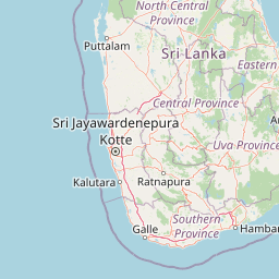
Understand where Kaudulla National Park sits in Sri Lanka through a broader geographic reading of the surrounding landscape, nearby location context, and its mapped position within the national park landscape.

How Kaudulla National Park fits into Sri Lanka

Sri Lanka is a tropical island nation in South Asia with a recorded history spanning over 3,000 years. Formerly known as Ceylon, it became independent in 1948 and adopted its current constitutional name in 1972. The country features diverse geography ranging from coastal plains to mountainous highlands and maintains a population exceeding 22 million.

Wider geography shaping Kaudulla National Park in Sri Lanka

Sri Lanka is an island nation in the Indian Ocean, positioned southwest of the Bay of Bengal. It is separated from India by the Gulf of Mannar and Palk Strait to the northwest. The island has a pear-like shape with diverse terrain including coastal plains, central highlands, and river valleys.

Map view of Kaudulla National Park

Use this park location map to pinpoint Kaudulla National Park in Sri Lanka, understand its exact geographic position, and read its mapped placement within the surrounding landscape more clearly.

Pigeon | © OpenStreetMap contributors

Location context for Kaudulla National Park

North Central Province
Park atlas

Explore the regional spread of conservation landscapes and mapped park geography in Sri Lanka's dry zone.

Discover Other National Parks and Protected Areas Near Kaudulla National Park
Browse a curated atlas of national parks and protected areas geographically adjacent to Kaudulla National Park in Sri Lanka's North Central province. Compare diverse dry zone ecosystems and connected wildlife corridors to deepen your understanding of the regional conservation landscape and park distribution.
National parkNorth Central Province

Minneriya National Park: A Protected National Park in North Central Province

Explore mapped boundaries and regional landscape context.

Minneriya National Park is a designated national park offering unique protected landscape exploration within Sri Lanka's North Central Province. This entry provides structured data crucial for understanding the park's geographic features, its defined boundaries, and its significance as a protected area. Dive into the atlas context that illuminates the natural terrain and regional setting of Minneriya National Park.

Area
88.894 km²
Established
1997
IUCN
II
Relief
Mixed relief
National parkNorth Central Province

Angammedilla National Park: Protecting the Watershed for Parakrama Samudra in North Central Province

Mapped dry evergreen forests and mountainous terrain boundaries.

Angammedilla National Park is a national park in Sri Lanka's North Central Province renowned for its pivotal role in safeguarding the drainage basin for the large Parakrama Samudra reservoir. This protected landscape features significant dry evergreen forest ecosystems and mountainous terrain, contributing to the region's ecological stability and wildlife habitats. Its establishment highlights a commitment to preserving vital natural resources and understanding the complex interplay between protected areas and regional geography.

Area
75.29 km²
Established
2006
IUCN
II
Relief
Mountain
National parkSri Lanka

Somawathiya National Park: A Sri Lankan National Park Protected Landscape

Explore its mapped boundaries and regional geography.

Delve into the geographic identity of Somawathiya National Park, a designated national park within Sri Lanka. This entry provides atlas-level insights into its protected landscape, mapped terrain, and the specific natural area context it offers. Understand Somawathiya National Park's place in the Sri Lankan geography for structured discovery, focusing on its protected status and mapped features without travel logistics.

Area
376.455 km²
Established
1986
IUCN
II
Relief
Lowland
National parkNorth Central Province

Flood Plains National Park: Sri Lanka's Vital Wetland and Elephant Corridor

Mapping the geography of its unique villus system and Mahaweli River flood plain.

Flood Plains National Park stands as a paramount protected wetland ecosystem in Sri Lanka's North Central Province, critically important as an elephant corridor along the Mahaweli River. The park's landscape is defined by its unique villus system, shallow swampy depressions that support extraordinary biodiversity and serve as vital feeding grounds for Asian elephants and migratory waterfowl. Understanding the mapped park boundaries and its regional geographic context reveals its significance in landscape-level conservation efforts within the Mahaweli basin.

Area
173.5 km²
Established
1984
IUCN
II
Relief
Lowland
National parkCentral Province

Wasgamuwa National Park: A National Park in Central Province for Geographic Exploration

Mapped protected boundaries and landscape context.

Wasgamuwa National Park is a significant national park located in Sri Lanka's Central Province, offering valuable data for atlas exploration and geographic understanding. This protected area's mapped boundaries and regional setting within Central Province provide essential context for researchers and explorers focused on conservation landscapes. Discover the park's unique geographic identity and its contribution to the regional atlas, highlighting its role as a structured natural landscape.

Area
393.22 km²
Established
1984
IUCN
II
Relief
Upland
National parkNorth Central Province

Horowpathana National Park: Protected Landscape within North Central Province's Dry Zone

Explore its mapped boundaries and vital wildlife habitat.

Horowpathana National Park is a designated national park in Sri Lanka's North Central Province, covering 2,570 hectares of dry zone forest. Established to protect critical habitats for endangered species like the Sri Lankan elephant and leopard, it plays a vital role in regional wildlife conservation and managing human-wildlife conflict. Its landscape is characterized by dry forest ecosystems situated near the Tawalamham Hammillewa reservoir system, presenting a unique environmental context within the broader mapped geography of the island.

Area
25.7 km²
Established
2011
IUCN
II
Climate
Tropical
Watercolor illustration of a landscape with a lake, grassy areas, trees, and distant hills under a pale sky
National park

Wilpattu National Park: Sri Lanka's Largest National Park and Unique Willu Landscape

Explore mapped boundaries and high leopard density geography.

Wilpattu National Park, located in Sri Lanka's northwest coastal lowland dry zone, is the country's largest and one of its oldest national parks. Its landscape is defined by a unique system of nearly 106 natural sand-rimmed water basins, or willu, creating a distinctive wetland environment. The park is globally recognized for its substantial leopard population, representing one of the highest densities recorded in Sri Lanka. Discover the mapped terrain and protected area context of this ecologically vital landscape.

Area
1,316.67 km²
Established
1938
IUCN
II
Relief
Lowland
National parkNorthern Province

Madhu Road National Park: Sri Lanka's Northern Province Dry Zone National Park

Explore protected landscapes and mapped geography.

Madhu Road National Park, situated in Sri Lanka's Northern Province, is a significant protected area defined by its dry zone ecosystems, including forests, grasslands, and wetlands. As one of the island's larger national parks, it offers critical habitat for diverse wildlife and represents an important component of northern Sri Lanka's conservation efforts. This page provides detailed atlas-style insights into the park's geography, mapped boundaries, and its ecological context within the region.

Area
631 km²
Established
2015
IUCN
II
Climate
Tropical

Common questions about visiting, size, designation, and location context for Kaudulla National Park

Kaudulla National Park FAQs for park facts, access, geography, and protected area context
Find quick answers about Kaudulla National Park, including protected-area facts, park geography, trail and visitor context, and how the park fits into its surrounding country and regional landscape.
MoriAtlas Explorer

Continue Your Protected Areas Search Across the Global Atlas

Deepen your exploration by continuing the structured search for national parks and protected areas worldwide. Utilize the comprehensive filtering capabilities to compare different conservation landscapes and refine your understanding of global park geography. Discover more about the distribution and characteristics of protected natural areas.

Global natural geography