

Mori Atlas logo
National parkHorton Plains National Park

Discover the mapped boundaries and regional context of this significant national park.

Horton Plains National Park: Sri Lanka's Protected Landscape and Geographic Atlas Entry

Horton Plains National Park stands as a crucial protected area within Sri Lanka's Central Province, offering a distinct focus for geographic discovery. This page serves as an atlas entry, detailing the park's mapped boundaries and its place within the island's broader natural landscape. Explore the specific geographic identity of this national park and understand its role in the conservation of protected lands.

Montane GrasslandCloud ForestEndemic BiodiversityWorld Heritage SiteHighland EcosystemsImportant Bird Area

Horton Plains National Park

National park

Park overview

Structured park overview, official facts, and landscape profile for Horton Plains National Park

Horton Plains National Park park facts, protected area profile, and essential visitor context
Review the core facts for Horton Plains National Park, including designation, size, terrain, visitor scale, habitats, and operating context in one park-focused overview.

About Horton Plains National Park

Horton Plains National Park occupies a distinctive position in Sri Lanka's protected area network as the highest national park on the island and one of the most ecologically significant highland ecosystems in South Asia. The park is located on the southern plateau of the central highlands, bordered by Thotupalakanda Nature Reserve and contiguous with Peak Wilderness Sanctuary to the west. The landscape comprises a rolling plateau surrounded by some of Sri Lanka's highest peaks, including Kirigalpoththa (2,389 meters) and Thotupola Kanda (2,357 meters), the second and third highest points on the island. The geology dates to the Archean era, among the oldest rock formations in Sri Lanka, consisting primarily of Khondalites, Charnockites, and granitic gneisses that have been extensively metamorphosed. The plateau's elevation and isolation have created unique ecological conditions, with montane grasslands interspersed with patches of cloud forest that represent the most extensive remaining examples of this ecosystem type in Sri Lanka. The park's hydrological significance cannot be overstated, as the Horton Plains serve as the primary headwaters for the Mahaweli, Kelani, and Walawe rivers, three of Sri Lanka's most important river systems, as well as several smaller streams including Belihul Oya, Agra Oya, and Kiriketi Oya. The combination of high rainfall, frequent cloud cover, and nutrient-poor soils has produced a distinctive vegetation pattern characterized by stunted trees, extensive grasslands, and a ground flora adapted to cool, perpetually moist conditions.

Quick facts and research context for Horton Plains National Park

Horton Plains National Park occupies a plateau in Sri Lanka's Central Province at elevations ranging from 1,200 to 2,300 meters. The area features Precambrian-eraKhondalite, Charnockite, and granitic gneiss formations, with red-yellow podsolic soils supporting distinctive montane vegetation. Mean annual rainfall exceeds 2,000 millimeters while mean annual temperature hovers around 13°C, with dramatic daily fluctuations between 5°C and 27°C. The park contains the most extensive remaining cloud forest in Sri Lanka and serves as a critical drainage basin for the island. It was designated as a wildlife sanctuary in 1969 and upgraded to national park status in 1988, now managed by the Department of Wildlife Conservation.

Park context

Deeper park guide and search-rich context for Horton Plains National Park

Horton Plains National Park history, landscape, wildlife, and travel context
Explore Horton Plains National Park through its history, landscape character, ecosystems, wildlife, conservation priorities, cultural context, and seasonal travel timing in a structured park guide built for atlas discovery and search intent.

Why Horton Plains National Park stands out

Horton Plains is renowned for its dramatic geological features and exceptional endemism. The park's signature attraction is World's End, a spectacular sheer cliff precipice dropping 870 meters to the valley below, offering one of Sri Lanka's most breathtaking viewpoints. Baker's Falls, a 20-meter waterfall named after Sir Samuel Baker, provides another notable landmark. The park's cloud forests support extraordinary biodiversity, with approximately 54 woody plant species recorded, half of which are endemic to Sri Lanka. The montane grasslands harbor unique herbaceous flora including temperate genera such as Ranunculus, Pedicularis, and Gentiana alongside tropical species. The park is also famous for its population of Sri Lankan sambar deer, which roam the plains in large herds, and as a stronghold for highland endemic bird species.

Horton Plains National Park history and protected-area timeline

The history of Horton Plains reflects the broader colonial and conservation history of Sri Lanka's central highlands. The original Sinhala name for the area was Maha Eliya Thenna, meaning "great open plain," referring to the expansive grassland plateau. The current name honors Sir Robert Wilmot-Horton, British Governor of Ceylon from 1831 to 1837, who visited the area in 1836 to meet the Ratemahatmaya of Sabaragamuwa. The "discovery" of the plateau is attributed to Lieutenant William Fisher of the 78th Regiment and Lieutenant Albert Watson of the 58th Regiment in 1834. Archaeological evidence, including stone tools dating to the Balangoda culture, indicates human presence in the area for thousands of years, with local lowland populations ascending the mountains to mine gems, extract iron ore, and harvest timber. The conservation movement in Sri Lanka gained momentum in the late 19th century, prompted by botanist Joseph Dalton Hooker's recommendation to preserve montane forests above 5,000 feet. An administrative order in 1873 prohibited forest clearing in these areas. Horton Plains was designated as a wildlife sanctuary on December 5, 1969, and elevated to national park status on March 18, 1988, following recognition of its exceptional biodiversity value. Potato cultivation in the grasslands, which had begun during the colonial period, ceased in 1977, and these areas were subsequently restored as natural grassland.

Horton Plains National Park landscape and geographic character

The physical landscape of Horton Plains is defined by its high-altitude plateau setting and dramatic topographic features. The park occupies a relatively flat plateau surface surrounded by steep-sided valleys and mountains, with elevation ranging from 1,200 meters at the lowest points to 2,300 meters on the plateau itself. The most spectacular geological feature is World's End, a near-vertical cliff with a 870-meter drop that provides sweeping views across the southern plains of Sri Lanka. Adjacent to World's End is Baker's Falls, a 20-meter waterfall formed by Belihul Oya, a tributary of the Walawe River, named after Sir Samuel Baker who served as a colonial administrator. Smaller waterfalls including Slab Rock Falls also dot the landscape. The underlying geology consists of ancient Precambrian rocks, primarily Khondalites, Charnockites, and granitic gneisses that have undergone extensive metamorphic processes. The soils are classified as red-yellow podsolic, with a surface layer rich in decayed organic matter from the dense vegetation. The park contains numerous pools and marshy areas, particularly in depressions where water collects during the wet season, creating habitat for aquatic plants and wetland fauna.

Horton Plains National Park ecosystems, habitats, and plant life

The ecological character of Horton Plains is defined by the interplay between montane grassland and cloud forest ecosystems, creating a mosaic of habitats of exceptional conservation significance. The park's vegetation is divided into approximately 2,000 hectares of wet patana (montane grasslands and shrublands) and 1,160 hectares of subtropical montane evergreen forest. Nearly 750 plant species from 20 families have been recorded within the park, with approximately 54 woody plant species, of which 27 are endemic to Sri Lanka. The cloud forest canopy reaches heights of around 20 meters, dominated by Calophyllum walkeri in association with Myrtaceae species including Syzygium rotundifolium and S. sclerophyllum, and Lauraceae members such as Litsea, Cinnamomum, and Actinodaphne speciosa. The undergrowth layer is characterized by dense thickets of Strobilanthes species, which can hinder the development of a herb layer. Dwarf bamboo species including Indocalamus and Ochlandra are also present. The montane grasslands are dominated by Arundinaria villosa and Chrysopogon zeylanicus, with herbaceous flora including both temperate species (Ranunculus, Pedicularis, Senecio, Gentiana, Alchemilla) and tropical species such as Eriocaulon and Ipsea speciosa. The park's high-altitude position, frequent cloud cover, and high rainfall have created conditions favorable for the persistence of relict plant species with Himalayan and Western Ghats affinities, including Rhododendron arboreum and Gordonia, which colonized Sri Lanka along these mountain ranges.

Horton Plains National Park wildlife and species highlights

The fauna of Horton Plains reflects the park's position as a highland ecosystem with remarkable levels of endemism. Twenty-four mammal species, 87 bird species, nine reptile species, and eight amphibian species have been recorded. The Sri Lankan sambar deer is the most commonly observed large mammal, occurring in large herds that number between 1,500 and 2,000 individuals. Other mammals include Kelaart's long-clawed shrew, toque macaques, purple-faced langurs, rusty-spotted cats, Sri Lankan leopards, wild boars, stripe-necked mongooses, Sri Lankan spotted chevrotains, Indian muntjacs, and grizzled giant squirrels. The park is notable for the Horton Plains slender loris (Loris tardigradus nycticeboides), considered one of the world's most endangered primates, which was photographed for the first time in 2010 by researchers from the Zoological Society of London. As an Important Bird Area, Horton Plains supports 21 bird species endemic to Sri Lanka, including three species restricted to the park: the dull-blue flycatcher, Sri Lanka white-eye, and Sri Lanka wood pigeon. Six highland endemic bird species are found here. The park is also significant for amphibians, with approximately 15 species including Microhyla zeylanica, Uperodon palmatus, and several Pseudophilautus species, and reptiles including Calotes nigrilabris and the rhino-horned lizard.

Horton Plains National Park conservation status and protection priorities

Horton Plains faces several significant conservation challenges despite its protected status. Forest dieback, first reported in 1978, has affected nearly 50% of vegetation in some peripheral areas, with 22 plant species impacted. This phenomenon has been attributed to water deficiency from increasingly frequent droughts, exacerbated by severe frost that hinders forest regrowth. Soil acidification caused by low calcium levels and increased aluminum toxicity may also contribute to the dieback. Invasive species including gorse (Ulex europaeus), Mist Flower (Ageratina riparia), Crofton Weed (Ageratina adenophora), Blue Stars (Aristea ecklonii), and various Pennisetum species threaten native flora. Tourism-related impacts such as plant removal, littering, fires, and noise pollution pose ongoing challenges, as does illegal logging, poaching, and gem mining. The introduced rainbow trout may have negatively affected endemic fish, amphibians, and crustaceans. The park's relatively small size means that most male leopards have activity centers outside the park boundaries, necessitating integrated landscape management beyond the national park for effective species conservation. Sambar deer mortality from polythene litter ingestion has prompted visitor restrictions on plastic materials.

Horton Plains National Park cultural meaning and human context

While Horton Plains is primarily significant for its ecological values, the area has a long history of human interaction. Archaeological evidence, including stone tools from the Balangoda culture, demonstrates human presence on the plateau for thousands of years. Local populations from lower elevations historically ascended the mountains to mine gems, extract iron ore, construct irrigation channels, and harvest timber. The original Sinhala name, Maha Eliya Thenna, reflects the indigenous understanding of the landscape as a great open plain. The British colonial period brought significant changes, including the establishment of the area as a hunting ground for sambar deer between 1831 and 1948, and the clearing of lower slopes for coffee and subsequently tea plantations, which fragmented the park's connection to other forest and grassland areas. The renaming of the area after Governor Robert Wilmot-Horton exemplifies the colonial practice of attaching European names to newly "discovered" landscapes.

Top sights and standout views in Horton Plains National Park

Horton Plains National Park offers a combination of dramatic landscapes, unique ecosystems, and exceptional biodiversity that distinguishes it within Sri Lanka's protected area network. The spectacular World's End viewpoint, with its 870-meter vertical drop, provides one of the most awe-inspiring views in South Asia. The cloud forests, representing the most extensive remaining example of this ecosystem in Sri Lanka, support numerous endemic species found nowhere else on Earth. The montane grasslands create a landscape of remarkable beauty, particularly when cloaked in morning mist. The park's role as the headwaters for three major river systems underscores its importance beyond biodiversity, extending to watershed protection for much of Sri Lanka. The presence of the endangered Horton Plains slender loris and six endemic highland bird species highlights the park's global significance for conservation. The inclusion of the Central Highlands of Sri Lanka on the World Heritage List in 2010 recognizes these outstanding universal values.

Best time to visit Horton Plains National Park

The best time to visit Horton Plains depends on the experience sought, with different seasons offering distinct advantages. The dry season from January to March typically offers more stable weather conditions, with lower rainfall and clearer skies that provide optimal visibility at viewpoints like World's End. However, this period can also bring cold temperatures, with night-time readings dropping to around 5°C, and ground frost is common in February. The wet season, coinciding with the southwest monsoon from May to September, brings higher rainfall and more frequent mist that can obscure views but creates the atmospheric conditions that sustain the cloud forest ecosystem. The park experiences mean annual rainfall exceeding 2,000 millimeters, with some rain possible throughout the year. Visitors should be prepared for rapidly changing conditions regardless of season, and the cool temperatures at this altitude mean that warm clothing is advisable year-round.

Park location guide

Geography guide, regional context, and park location map for Horton Plains National Park

Horton Plains National Park park geography, regions, and map view in Sri Lanka
Understand where Horton Plains National Park sits in Sri Lanka through a broader geographic reading of the surrounding landscape, nearby location context, and its mapped position within the national park landscape.

How Horton Plains National Park fits into Sri Lanka

Sri Lanka is a tropical island nation in South Asia with a recorded history spanning over 3,000 years. Formerly known as Ceylon, it became independent in 1948 and adopted its current constitutional name in 1972. The country features diverse geography ranging from coastal plains to mountainous highlands and maintains a population exceeding 22 million.

Wider geography shaping Horton Plains National Park in Sri Lanka

Sri Lanka is an island nation in the Indian Ocean, positioned southwest of the Bay of Bengal. It is separated from India by the Gulf of Mannar and Palk Strait to the northwest. The island has a pear-like shape with diverse terrain including coastal plains, central highlands, and river valleys.

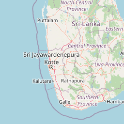
Map view of Horton Plains National Park

Use this park location map to pinpoint Horton Plains National Park in Sri Lanka, understand its exact geographic position, and read its mapped placement within the surrounding landscape more clearly.

Pigeon | © OpenStreetMap contributors

Location context for Horton Plains National Park

Central Province
Park atlas

Map connected protected landscapes and high-altitude ecosystems throughout Sri Lanka's Central Highlands, exploring regional park geography.

Discover Other National Parks and Protected Areas Near Horton Plains National Park in Sri Lanka
After exploring Horton Plains National Park, browse other national parks and protected areas across Sri Lanka's Central Highlands and surrounding montane landscapes. Compare diverse ecosystems, from cloud forests to highland grasslands, and understand their regional conservation context within this significant World Heritage Site.
National parkCentral Province

Galways Land National Park: A Protected Landscape within Central Province, Sri Lanka

Explore the mapped geography and protected area context of this national park.

Galways Land National Park is a designated national park within the Central Province of Sri Lanka, offering a distinct focus for geographic exploration. This entry provides specific details on its protected landscape characteristics and its place within the regional atlas. Users can examine the mapped boundaries and understand the natural terrain that defines this conservation area. Discover the unique geographic identity of Galways Land National Park and its contribution to the protected areas network.

Area
0.27 km²
Established
2006
IUCN
II
Relief
Mountain
National parkSri Lanka

Udawalawe National Park: National Park Protected Landscape and Geographic Atlas

Explore Sri Lanka's mapped natural terrain and park boundaries.

Gain a comprehensive atlas-level understanding of Udawalawe National Park, a key protected landscape in Sri Lanka. This entry focuses on the park's distinct geographic identity, its mapped boundaries, and its significance as a protected area within the island's diverse natural terrain. Explore how this national park contributes to the regional geography and provides structured insights for landscape discovery.

Area
308.21 km²
Established
1972
IUCN
II
Visitors
188.4K annual
National parkSri Lanka

Lunugamvehera National Park: Sri Lanka's Protected Area Mapping and Geographic Identity

Mapped terrain and national park boundaries in Sri Lanka.

Lunugamvehera National Park is a dedicated national park situated in Sri Lanka. This entry facilitates a focused exploration of its protected landscape, offering insight into its mapped geography and position within the country's conservation network. Understand the park's role and its physical characteristics through detailed geographic and atlas-oriented information.

Area
234.988 km²
Established
1995
IUCN
II
Relief
Lowland
National parkUva Province

Gal Oya National Park: Protected Landscape and Reservoir Geography in Uva Province

Explore savannah grasslands, elephant populations, and mapped terrain.

Gal Oya National Park presents a unique protected landscape within Uva Province, Sri Lanka. This national park is defined by its broad savannah grasslands, known as thalawa, interspersed with forested hills and the vast Senanayake Samudraya reservoir. Its varied topography, from lowlands to mountain peaks, offers a rich canvas for geographic exploration and understanding protected-area dynamics. The park's consistent visibility of elephant populations across these diverse terrains makes it a key site for wildlife observation within Sri Lanka's atlas of natural heritage.

Area
259 km²
Established
1954
IUCN
II
Relief
Mountain
Watercolor illustration of a landscape with green hills, grassy foreground, and pink sky
National parkSri Lanka

Ussangoda National Park: Sri Lanka's National Park and Protected Landscape Atlas Entry

Mapped protected boundaries and regional geographic context.

Ussangoda National Park represents a vital component of Sri Lanka's protected natural areas, offering unique insights into its landscape and geography. This atlas entry focuses on the park's identity as a national park, providing a detailed view of its mapped boundaries and its specific location within the island's diverse geography. Understand the protected land context and the unique characteristics that define Ussangoda National Park for focused geographic discovery.

Area
3.49 km²
Established
2010
IUCN
II
Relief
Upland
National parkWestern Province

Horagolla National Park: Sri Lanka's Mapped Protected National Park in Western Province

Explore geographic boundaries and protected landscape context.

Horagolla National Park represents a significant protected natural area within Sri Lanka's Western Province. This detail page offers users the opportunity to examine the park's specific geographic setting, its mapped protected boundaries, and its overall context within the island's atlas of natural landscapes. Gain a structured understanding of this national park entity and its regional geographic features.

Area
0.33 km²
Established
1973
IUCN
II
Relief
Lowland
National parkSouthern Province

Yala National Park: National Park Protected Landscape and Geographic Exploration

Mapped boundaries and regional context in Southern Province

Investigate Yala National Park, a protected national park situated in the Southern Province of Sri Lanka. This entry focuses on its geographic identity, detailing mapped boundaries and the surrounding landscape context crucial for atlas-based exploration and understanding protected area distributions. Gain insight into the park's role as a significant natural landmark.

Area
978.807 km²
Established
1938
IUCN
II
Visitors
400K annual
National parkEastern Province

Lahugala Kitulana National Park: Eastern Province National Park Protected Landscape Discovery

Explore mapped boundaries and regional geography.

Lahugala Kitulana National Park is a key protected area, designated as a national park within Sri Lanka's Eastern Province. This content focuses on its geographic identity, including mapped park boundaries and its regional landscape context. Gain a structured understanding of this protected natural land for atlas-based exploration, highlighting its geographical significance and protected status.

Area
15.54 km²
Established
1980
IUCN
II
Relief
Lowland

Common questions about visiting, size, designation, and location context for Horton Plains National Park

Horton Plains National Park FAQs for park facts, access, geography, and protected area context
Find quick answers about Horton Plains National Park, including protected-area facts, park geography, trail and visitor context, and how the park fits into its surrounding country and regional landscape.
MoriAtlas Explorer

Continue Your Protected Areas Search Across the Global Atlas

Deepen your exploration by continuing the structured search for national parks and protected areas worldwide. Utilize the comprehensive filtering capabilities to compare different conservation landscapes and refine your understanding of global park geography. Discover more about the distribution and characteristics of protected natural areas.

Global natural geography