
Streams
Park geography
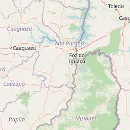
Detailed spatial analysis covering regional landscape context, waterfall distribution, and park area
Comprehensive Geographic Profile and Mapped Boundaries of Iguazú National Park, Misiones Province
Analyze the formal geographic scope of Iguazú National Park, spanning 677 square kilometers within Misiones Province. This spatial profile maps the primary tropical forest and riverine environments, characterizing the terrain as a lowland system defined by dominant waterfalls and extensive river networks.
Related tags
waterfallsubtropical forestAtlantic forestUNESCO World Heritage SiteIUCN Category II
Argentina's crown jewel of subtropical waterfalls and Atlantic forest wilderness
Iguazú National Park
Iguazú National Park is a premier protected area in northeastern Argentina, spanning 677 square kilometers of pristine subtropical wilderness in the province of Misiones. The park is world-renowned for protecting the spectacular Iguazú Falls, a cascading waterfall system consisting of approximately 275 individual falls that create one of the most dramatic natural spectacles in South America. The falls sit at the confluence of the Iguazú River and the Paraná River, where the river plummets through a series of gorges and cliffs in a horseshoe-shaped canyon. Beyond the falls, the park preserves one of the most biologically diverse remaining tracts of Atlantic forest in the continent, supporting the Alto Paraná Atlantic forests ecoregion, which is recognized as a global biodiversity hotspot.
- Location
- Argentina
- Park type
- National park
- Established
- 1934
- Area
- 677 km²
Location overview
Mapping the country borders and provincial boundaries of the park
Geographic Location of Iguazú National Park in Argentina and Paraguay
Iguazú National Park is located within Argentina and Paraguay, including parts of Misiones Province. Verified country relationships and regional listings establish administrative boundaries for the protected area.
- Countries
- Argentina
- Regions
- Misiones Province
- Primary location
- Misiones Province
Boundary and coordinates
Protected landscape measurements and coordinates across 677 square kilometers.
Geographic Boundary Map and Spatial Extent of Iguazú National Park
Mapped boundary outlines offer clear spatial context for the protected terrain of Iguazú National Park. Integrated geographic facts provide calculated area metrics, coordinate spans, and center points to assist with regional navigation.
- Boundary area
- 510.8 km²
- Boundary perimeter
- 125.6 km
- Northernmost point
- 25.5346° S
- Southernmost point
- 25.7613° S
- Easternmost point
- 54.1616° W
- Westernmost point
- 54.4778° W
- Geographic centre
- 25.6677° S, 54.2855° W
- North–south span
- 25.1 km
- East–west span
- 31.8 km
Terrain and natural features
Recorded lowland relief classifications and internal water features
Iguazú National Park Terrain and Named Natural Features
Iguazú National Park contains recorded lowland terrain classifications alongside internal streams, waterfalls, and viewpoints. Individual feature cards provide specific types, measurements, and spatial relationships.
Selected named natural features
Waterfalls
Salto Mbiguá
Streams
Arroyo Yacuy Chico
Waterfalls
Salto Chico
Waterfalls
Salto Unión
Viewpoints
Mirador Salto Chico superior
Environmental setting
Subtropical lowland forest and dominant water features shaping the regional setting
Iguazú National Park Environmental Setting and Subtropical Landscape Classifications
Stored classifications combine lowland relief, tropical forest cover, and dominant water features into complementary settings for the park. Recorded categories connect directly to related protected areas and mapped atlas destinations.
- Relief
- Lowland
- Climate
- Subtropical
- Water
- Water-dominated
- Forest cover
- Dense forest cover
Landscape features
Waterfalls · Rivers · Forest
Habitat types
Tropical forest · Riverine habitat
Park atlas
Explore Surrounding Conservation Landscapes and Regional Park Geography in South America
Discover Other National Parks and Protected Areas Near Iguazú National Park, Argentina
After exploring Iguazú National Park, map other significant national parks and protected areas across Argentina and the broader South American subtropical region. This view helps you trace geographic connections, compare diverse conservation landscapes, and understand the regional distribution of essential Atlantic forest ecosystems.
State or regional parkMisiones Province
Park boundaries overlap#1 closest
Southeast

Urugua-í Provincial Park: Exploring the Atlantic Forest Landscapes of Misiones Province
A regional atlas of protected watersheds and forest corridors
Spanning from the rolling lowlands of the Urugua-í River to the rugged slopes of the Sierra de la Victoria, this protected area represents one of the most significant forest blocks in the region. Examine the mapped drainage patterns, watershed connectivity, and forest mosaic that define this essential Argentine conservation landscape.
- Area
- 840 km²
- Established
- 1990
- IUCN
- II
- Relief
- Upland
Natural monumentAlto Paraná Department
About 12 km away#2 closest
West

Moisés Bertoni Scientific Monument: Protected Atlantic Forest in Alto Paraná, Paraguay
Natural monument and historic research landscape
Explore the geographic footprint of Moisés Bertoni Scientific Monument, an essential protected area in the Alto Paraná Department. This site safeguards mature Atlantic Forest ecosystems along the Paraná River while preserving the historic research station and cultural legacy of its founder. The monument remains a pivotal landmark for understanding the biodiversity and conservation landscape of eastern Paraguay.
- Area
- 1.99 km²
- Established
- 1955
- Relief
- Lowland
- Climate
- Subtropical

Wildlife reserveAlto Paraná Department
About 35 km away#3 closest
Northwest
Tatí Yupí Refuge: Wildlife Reserve Geography and Paraná River Landscape
A 2,245 hectare protected biological forest in Alto Paraná
Tatí Yupí Refuge offers a unique perspective on protected land management within the Itaipu hydroelectric complex. Explore the mapped boundaries, basaltic stream formations, and subtropical forest habitat that define this essential ecological refuge in Paraguay's Alto Paraná Department.
- Area
- 22.45 km²
- Established
- 1982
- Relief
- Lowland
- Climate
- Subtropical
National parkParaguay
About 43 km away#4 closest
Southwest
Ñacunday National Park National Park: Paraguay's Protected Landscape and Mapped Boundaries
Explore its unique geography and protected terrain.
Gain a precise understanding of Ñacunday National Park, a designated national park in Paraguay. This entry focuses on its role as a protected landscape, detailing its geographic attributes and mapped boundaries. It serves as a vital resource for users seeking specific information on the park's natural terrain and its contribution to Paraguay's conservation geography, facilitating structured discovery within the atlas.
- Area
- 20 km²
- Established
- 1993
- Relief
- Mixed relief
- Climate
- Subtropical
State or regional parkMisiones Province
About 120 km away#5 closest
South
Esmeralda Provincial Park: Protected Forest Landscapes and Geography in Misiones
A critical node in the Alto Parana Atlantic forest ecosystem
Esmeralda Provincial Park represents a significant protected area within the Misiones Province, acting as a core unit for the Yaboti Biosphere Reserve. The terrain is characterized by dense subtropical forest and rugged topography shaped by the Yaboti Guazu drainage network. This area serves as a primary site for forest biodiversity research, highlighting the ecological value of continuous, undisturbed forest tracts within the broader Argentine Mesopotamia region.
- Area
- 316.19 km²
- Established
- 1997
- IUCN
- II
- Relief
- Upland
Wildlife reserveCanindeyú Department
About 132 km away#6 closest
North
Refugio Carapá Wildlife Reserve: Mapping Biological Diversity in Canindeyú Department
A protected sub-tropical mosaic along the Paraná River basin
Refugio Carapá protects a dramatic stretch of mountain slopes and riverine valleys in the Department of Canindeyú. By managing a mosaic of tall forests, swamps, and open camp vegetation, the reserve maintains a crucial ecological link within the wider Itaipu reservoir landscape. The area functions as a research-focused environment dedicated to preserving native flora and threatened species in eastern Paraguay.
- Area
- 32.5 km²
- Established
- 1984
- Relief
- Mountain
- Climate
- Subtropical
National parkItapúa Department
About 148 km away#7 closest
Southwest
San Rafael National Park: National Park Protected Landscape & Geographic Overview
Discover the mapped boundaries and regional setting in Itapúa.
San Rafael National Park is a significant protected area designated as a national park in Paraguay's Itapúa Department. This page serves as an atlas-centric entry point, offering a detailed view of its geographic scope, mapped park boundaries, and its role as a conservation landscape. Users can explore the park's terrain and its place within the regional geography for a structured understanding of its protected status.
- Area
- 693.04 km²
- Established
- 1992
- IUCN
- II
- Relief
- Upland

Nature reserveCanindeyú Department
About 196 km away#8 closest
Northwest
Mbaracayú Forest Nature Reserve: A Detailed Geographic Atlas of Paraguay's Protected Forest
Mapped terrain, forest corridors, and landscape features
Spanning over 64,000 hectares in the Canindeyú Department, Mbaracayú Forest Nature Reserve preserves the core of the Alto Paraná Atlantic forest. The area features a complex mosaic of subtropical forest, riparian corridors, and the undulating slopes of the Cordillera de Mbaracayú range. This map-focused profile details the reserve's unique topography, stream networks, and its vital role as a continuous wilderness block in eastern Paraguay.
- Area
- 644.05 km²
- Established
- 1991
- IUCN
- II
- Relief
- Upland
MoriAtlas Explorer
Continue Exploring Iguazú National Park's Geographic Context and Mapped Terrain
Deepen your understanding of Iguazú National Park by examining its specific geographic features and protected landscape boundaries. This focused view within Misiones Province provides essential data for atlas exploration and appreciating the park's role within Argentina's network of natural areas. Continue to trace its mapped terrain and regional context for a comprehensive geographic perspective.
Browse next
Global natural geography
Explore related park routes
Explore MoriAtlas Global ParksBrowse All MoriAtlas ParksGlobal Park Map DiscoveryMoriAtlas: Browse All CountriesBrowse All MoriAtlas ContinentsNational Park Environment AtlasGrand Canyon National Park AtlasYellowstone National Park AtlasYosemite National Park Atlas and GeographySerengeti National Park AtlasGalápagos National Park Protected LandscapeBanff National Park Geography and AtlasKruger National Park Atlas EntryUluṟu-Kata Tjuṯa National Park AtlasExplore Uluru-Kata Tjuta National Park GeographyPlitvice Lakes National Park AtlasFiordland National Park Protected LandscapeGreat Smoky Mountains National Park AtlasAfghanistan National Parks and Protected AreasAlbania National Parks and Protected AreasAlgeria National Parks and Protected AreasAmerican Samoa National Parks and Protected AreasAndorra National Parks and Protected AreasAngola National Parks and Protected AreasAntarctica National Parks and Protected AreasAntigua and Barbuda Park List