Mori Atlas logo
National parkIguazú National Park

Discover the geographic extent and natural terrain of this significant national park.

Iguazú National Park: Protected Landscape Geography and Mapped Boundaries in Misiones Province

(Parque Nacional Iguazú)

Iguazú National Park represents a vital protected natural area within Argentina's Misiones Province. This page offers an atlas-driven view of the park's precise geographic scope, its mapped boundaries, and its contribution to the regional landscape context. Explore the unique natural terrain that defines this national park, providing a foundation for structured geographic discovery and understanding its place within the broader protected lands network.

waterfallsubtropical forestAtlantic forestUNESCO World Heritage SiteIUCN Category IISouth America

Iguazú National Park

National park

Park overview

Structured park overview, official facts, and landscape profile for Iguazú National Park

Iguazú National Park park facts, protected area profile, and essential visitor context
Review the core facts for Iguazú National Park, including designation, size, terrain, visitor scale, habitats, and operating context in one park-focused overview.

About Iguazú National Park

Iguazú National Park occupies a remarkable position in northeastern Argentina, protecting a portion of the Alto Paraná Atlantic forests, one of the most biodiverse ecosystems in the world. The park's defining feature is the Iguazú Falls, a UNESCO World Heritage Site since 1984, which draws visitors from around the globe to witness its extraordinary display of natural power. The falls are not a single cascade but a complex system of waterfalls, rapids, and mist-filled gorges that create a constantly shifting landscape of water and sound. The surrounding forest, classified as subtropical jungle, contains an extraordinary density of plant and animal species, many of which are endemic to this ecoregion. The park's landscape is characterized by rolling terrain, deep river valleys, and dense vegetation that creates a cathedral-like atmosphere beneath the forest canopy. The Iguazú River, which originates in the Brazilian highlands and travels 1,320 kilometers before reaching the park, is the lifeblood of the ecosystem, supporting both the waterfall system and the riparian forests along its banks.

Quick facts and research context for Iguazú National Park

Iguazú National Park is located in the Iguazú Department of Misiones Province in Argentina's Mesopotamia region, bordering Brazil. Established in 1934, the park covers 677 square kilometers of subtropical forest and is managed by Argentina's Administración de Parques Nacionales. The park was designated a UNESCO World Heritage Site in 1984, sharing this recognition with the adjacent Iguaçu National Park in Brazil. The name Iguazú derives from the Guaraní language, where 'y guasu' means 'large water,' reflecting the indigenous heritage of the region.

Park context

Deeper park guide and search-rich context for Iguazú National Park

Iguazú National Park history, landscape, wildlife, and travel context
Explore Iguazú National Park through its history, landscape character, ecosystems, wildlife, conservation priorities, cultural context, and seasonal travel timing in a structured park guide built for atlas discovery and search intent.

Why Iguazú National Park stands out

Iguazú National Park is best known for the Iguazú Falls, widely considered one of the most impressive waterfall systems in the world. The falls consist of approximately 275 individual falls distributed across a 2.7-kilometer front, with some cascades reaching heights of 82 meters. The falls are situated within a dramatic landscape where the Iguazú River, up to 1,500 meters wide within the park, plunges into a series of steep canyons before joining the Paraná River. The surrounding subtropical jungle provides a lush backdrop to the waterfall system and is home to exceptional biodiversity. The combination of the waterfall's sheer scale, the surrounding forest, and the ecological significance of the Atlantic forest ecoregion makes this park one of the most iconic protected areas in South America.

Iguazú National Park history and protected-area timeline

The territory now protected by Iguazú National Park has a rich human history stretching back thousands of years. Archaeological evidence indicates that hunter-gatherer societies of the Eldoradense culture inhabited the area around 10,000 years ago. These early inhabitants were eventually displaced around 1,000 CE by the Guaraní people, who brought advanced agricultural technologies and established lasting cultural traditions in the region. The name 'Iguazú' itself comes from the Guaraní words 'y' (water) and 'guasu' (large), literally translating to 'large water.' European exploration began in 1541 when Álvar Núñez Cabeza de Vale became the first recorded European to reach the falls, though Jesuit missionaries established settlements in the region beginning in 1609. The park was officially created in 1934 specifically to protect the Iguazú Falls and the surrounding natural environment, representing one of Argentina's earliest national park designations. In 1970, the Iguazú National Reserve was established to allow controlled development in the western portion of the region, permitting infrastructure for tourism including an international airport and hotel facilities. The park forms part of a transboundary conservation complex with Brazil's Iguaçu National Park, with both sites achieving World Heritage status in 1984.

Iguazú National Park landscape and geographic character

The landscape of Iguazú National Park is defined by the dramatic interaction between the Iguazú River and the underlying geology. The river flows through the park in a distinctive U-shaped course, first turning south and then north, creating a natural amphitheater that concentrates the waterfall system. Within the park boundaries, the river widens to up to 1,500 meters before plunging over the basalt cliffs that form the falls. The terrain consists of rolling hills and steep valleys carved by water over millions of years, with the falls themselves situated where the river encounters a series of hard basaltic rock formations that create the cascading drops. The surrounding landscape is covered in dense subtropical forest with a多层 canopy that filters sunlight and creates a perpetually humid environment. The vegetation along the riverbanks is particularly lush, featuring towering trees, epiphytes, and a dense understory of ferns and palms. The contrast between the plunging white water and the deep green of the surrounding forest creates one of the most visually striking landscapes in South America.

Iguazú National Park ecosystems, habitats, and plant life

The park lies within the Alto Paraná Atlantic forests ecoregion, a biome that once covered vast stretches of eastern Paraguay, Argentina, and Brazil but now exists largely in fragmented patches due to agricultural expansion. The Iguazú National Park represents one of the largest remaining continuous blocks of this critically important forest type. The vegetation within the park exhibits typical Atlantic forest characteristics, including a dense canopy reaching 30 to 40 meters in height, multiple layers of vegetation, and extraordinary species diversity. Key tree species include the ceibo (Erythrina crista-galli), whose striking red flower is Argentina's national symbol, the lapacho negro (Tabebuia heptaphylla) and lapacho amarillo (Tabebuia pulcherrima), both prized for their spectacular blooms, the palmito (a type of palm), and the towering palo rosa (Aspidosperma polyneuron) which can reach heights of 40 meters. The humid subtropical climate supports continuous growth cycles, allowing the forest to maintain its dense green appearance year-round. The forest also supports numerous epiphytes, lianas, and climbing plants that add to the three-dimensional complexity of the ecosystem.

Iguazú National Park wildlife and species highlights

The fauna of Iguazú National Park is exceptionally diverse, with the park serving as a critical refuge for numerous rare and threatened species. The park is home to several species of large Neotropical predators, including the jaguar, jaguarundi, and ocelot, which maintain populations in the forest's interior. The South American tapir, a large herbivore resembling a bizarre cross between a pig and an anteater, is also present along with the giant anteater itself. The birdlife is particularly notable, with species including the harpy eagle, one of the largest and most powerful raptors in the Americas, the black-fronted piping guan, a threatened arboreal bird, the vinaceous amazon with its distinctive wine-colored plumage, and the great dusky swift which can be observed swirling above the falls. Common mammals include the coatí, a relative of the raccoon that forages actively through the forest understory, while the yacare caiman inhabits the river channels and pools. The diversity of butterflies is extraordinary, with numerous species contributing to the park's vivid insect fauna.

Iguazú National Park conservation status and protection priorities

Iguazú National Park represents one of the most significant conservation achievements in South America, protecting a critical portion of the Atlantic forest biome and one of the world's natural wonders. The park's UNESCO World Heritage designation reflects both its outstanding universal value as a natural site and the international recognition of its ecological importance. The Alto Paraná Atlantic forests are classified as a global biodiversity hotspot, meaning they support extraordinary species diversity while facing significant threats from habitat loss and fragmentation. The park forms part of a larger proposed Trinational Biodiversity Corridor aimed at connecting protected areas across Argentina, Brazil, and Paraguay, creating forest corridors that allow wildlife to move between isolated conservation units. The park also adjoins Urugua-í Provincial Park to the southeast, a protected area of 84,000 hectares established in 1990, further extending the protected landscape. Conservation challenges include managing visitor impact while maintaining the park's natural integrity and addressing the broader regional pressures on Atlantic forest ecosystems.

Iguazú National Park cultural meaning and human context

The cultural landscape of Iguazú National Park carries the imprint of multiple human societies spanning thousands of years. The Guaraní people, who inhabited the region when Europeans first arrived, left a lasting legacy in the very name of the park and river. The Guaraní language term 'y guasu' meaning 'large water' reflects both the practical importance of the river system and the spiritual significance the falls held in indigenous belief systems. The arrival of Spanish and Portuguese conquistadores in the 16th century initiated a period of colonization that dramatically altered the region's human geography, though elements of Guaraní culture and language persist in the area to this day. The Jesuit missions established in the early 17th century introduced new religious and cultural frameworks while also bringing European agricultural practices. Today, the park exists at the intersection of conservation priorities, indigenous heritage, and growing tourism demands, representing both a natural and cultural landscape that continues to evolve.

Top sights and standout views in Iguazú National Park

The Iguazú Falls remain the undisputed highlight of the park, offering visitors the chance to experience one of the most powerful and beautiful waterfall systems on Earth from multiple perspectives. The Upper Circuit provides walkways that bring visitors to the edge of the Garganta del Diablo (Devil's Throat), the largest single cascade in the system. The Lower Circuit offers boat access and stunning views from below the falls. The surrounding subtropical forest provides equally compelling experiences, with well-maintained trails offering chances to observe diverse wildlife and experience the primal atmosphere of the Atlantic jungle. The ecological train system provides accessible transportation through the park, while the diverse fauna including jaguars, tapirs, harpy eagles, and numerous bird species reward patient observers. The transboundary relationship with Brazil's Iguaçu National Park creates a unified conservation landscape that protects the falls and forest on both sides of the international border.

Best time to visit Iguazú National Park

The park can be visited throughout the year, though each season offers distinct experiences. The waterfall display is most powerful during the Southern Hemisphere summer (December to March), when rainfall in the upstream basin is higher and the falls run with maximum volume. However, this period also coincides with higher temperatures and humidity in the subtropical climate. The winter months (June to September) typically see reduced water flow but offer more comfortable temperatures and clearer viewing conditions. Spring (October to November) often provides a balance with moderate water levels and pleasant weather. The park's subtropical climate means rain is possible year-round, and visitors should be prepared for sudden shower changes regardless of season. Wildlife viewing opportunities are generally better during the drier months when animals are more active near water sources.

Park location guide

Geography guide, regional context, and park location map for Iguazú National Park

Iguazú National Park park geography, regions, and map view in Argentina
Understand where Iguazú National Park sits in Argentina through a broader geographic reading of the surrounding landscape, nearby location context, and its mapped position within the national park landscape.

How Iguazú National Park fits into Argentina

Argentina is a federal republic located in the southern cone of South America, bordering Chile, Bolivia, Paraguay, Brazil, Uruguay, and the Atlantic Ocean. With an area of 2,780,085 km², it is the second-largest country in South America and the eighth-largest globally. The capital and largest city is Buenos Aires, and the official language is Spanish. The country claims sovereignty over the Falkland Islands, South Georgia and the South Sandwich Islands, and a portion of Antarctica.

Wider geography shaping Iguazú National Park in Argentina

Argentina occupies the southern portion of South America, sharing the Southern Cone region with Chile to the west. The country borders Bolivia and Paraguay to the north, Brazil to the northeast, Uruguay and the South Atlantic Ocean to the east, and the Drake Passage to the south. The Andes mountain range runs along the western border, while the Pampas plains dominate the central region. Argentina also claims territories in Antarctica.

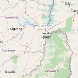
Map view of Iguazú National Park

Use this park location map to pinpoint Iguazú National Park in Argentina, understand its exact geographic position, and read its mapped placement within the surrounding landscape more clearly.

Pigeon | © OpenStreetMap contributors

Location context for Iguazú National Park

Misiones Province
Park atlas

Explore Surrounding Conservation Landscapes and Regional Park Geography in South America

Discover Other National Parks and Protected Areas Near Iguazú National Park, Argentina
After exploring Iguazú National Park, map other significant national parks and protected areas across Argentina and the broader South American subtropical region. This view helps you trace geographic connections, compare diverse conservation landscapes, and understand the regional distribution of essential Atlantic forest ecosystems.
National parkParaguay

Ñacunday National Park National Park: Paraguay's Protected Landscape and Mapped Boundaries

Explore its unique geography and protected terrain.

Gain a precise understanding of Ñacunday National Park, a designated national park in Paraguay. This entry focuses on its role as a protected landscape, detailing its geographic attributes and mapped boundaries. It serves as a vital resource for users seeking specific information on the park's natural terrain and its contribution to Paraguay's conservation geography, facilitating structured discovery within the atlas.

Area
20 km²
Established
1993
Relief
Mixed relief
Climate
Subtropical
National parkItapúa Department

San Rafael National Park: National Park Protected Landscape & Geographic Overview

Discover the mapped boundaries and regional setting in Itapúa.

San Rafael National Park is a significant protected area designated as a national park in Paraguay's Itapúa Department. This page serves as an atlas-centric entry point, offering a detailed view of its geographic scope, mapped park boundaries, and its role as a conservation landscape. Users can explore the park's terrain and its place within the regional geography for a structured understanding of its protected status.

Area
693.04 km²
Established
1992
IUCN
II
Relief
Upland
National parkParaguay

Ypoá National Park: Paraguay's Protected Wetland Landscape and Lake Ecosystem

Explore mapped boundaries and significant bird habitats in the Ñeembucú region.

Ypoá National Park is a critical protected area in Paraguay, renowned for its extensive wetland ecosystems dominated by Lake Ypoá. This national park encompasses a rich mosaic of marshlands, riparian forests, and aquatic vegetation, making it a significant habitat for numerous bird species, including several rare and endemic types. Its designation as a Ramsar Wetland underscores its ecological importance, offering a unique lens for understanding landscape context and protected-area geography within South America.

Area
1,000 km²
Established
1992
IUCN
II
Relief
Lowland
National parkFormosa Province

Río Pilcomayo National Park: Protected Humid Chaco Wetland Landscape & Geography

Explore mapped boundaries and unique floodplain terrain in Formosa Province.

Río Pilcomayo National Park represents a significant protected natural area within Argentina's Formosa Province, characterized by the unique ecosystems of the Humid Chaco. The park's landscape is defined by extensive floodplains, marshes, lakes, and forests, all influenced by the Pilcomayo River's dynamic hydrological cycle. As a Ramsar site, it safeguards crucial habitats, including those for the endangered jaguar, and showcases iconic Caranday palm savannas. This detailed atlas entry provides insights into its mapped geography and the vital protected landscape it preserves.

Area
518.89 km²
Established
1951
IUCN
II
Relief
Lowland
National parkCorrientes Province

Iberá National Park: National Park Atlas Exploration in Corrientes Province

Mapped protected area context and regional geography.

Delve into the atlas view of Iberá National Park, a designated national park situated in Corrientes Province, Argentina. This detailed entry clarifies the park's protected landscape identity and its contribution to the regional geography of northeastern Argentina. Understand its mapped boundaries and explore its significance as a conservation area within the Mesopotamia region.

Area
1,835 km²
Established
2018
IUCN
II
Relief
Lowland
National parkCorrientes Province

Mburucuyá National Park: National Park in Corrientes Province, Argentina

Iconic yatay palm savannas and diverse wetland ecosystems.

As a key national park within Argentina's Corrientes Province, Mburucuyá National Park offers a unique atlas-scale view of ecological convergence. It preserves expansive yatay palm savannas, critical wetland habitats within the Iberá Wetlands, and lush subtropical forests. The park's boundaries define an area where the Humid Chaco, Espinal, and Selva Paranaense biomes meet, creating a landscape of exceptional biodiversity and geographic significance for regional conservation and mapped exploration.

Area
176.82 km²
Established
2001
IUCN
II
Relief
Lowland
National parkChaco Province

Chaco National Park: Protected Landscape and Regional Geography Atlas

Explore mapped boundaries within the Eastern Chaco's unique ecosystem.

Chaco National Park is an important protected area in Chaco Province, Argentina, dedicated to preserving the unique Eastern Chaco ecosystem. Covering 150 square kilometers, its landscape comprises warm lowland terrain with scrubland, savanna, swamp areas, and scattered lakes. This national park is recognized for its efforts to conserve the distinctive quebracho forests and supports a rich array of wildlife, making it a key site for understanding regional protected-area geography and landscape context.

Area
150 km²
Established
1954
IUCN
II
Relief
Lowland
National parkArgentina

El Impenetrable National Park: A Protected National Park within Argentina's Geography

Explore its mapped boundaries and regional landscape context.

Delve into El Impenetrable National Park, a designated national park situated in Argentina. This entry provides critical geographic context, detailing its mapped protected area boundaries and its role within the national landscape. Understand its unique regional setting and explore its significance as a protected natural space for atlas-based discovery.

Area
1,289 km²
Established
2014
Relief
Lowland
Climate
Subtropical

Common questions about visiting, size, designation, and location context for Iguazú National Park

Iguazú National Park FAQs for park facts, access, geography, and protected area context
Find quick answers about Iguazú National Park, including protected-area facts, park geography, trail and visitor context, and how the park fits into its surrounding country and regional landscape.
MoriAtlas Explorer

Continue Your Protected Areas Search Across the Global Atlas

Deepen your exploration by continuing the structured search for national parks and protected areas worldwide. Utilize the comprehensive filtering capabilities to compare different conservation landscapes and refine your understanding of global park geography. Discover more about the distribution and characteristics of protected natural areas.

Global natural geography