

Mori Atlas logo
National parkIrazú Volcano National Park

Map exploration and geographic context for this significant national park entity.

Irazú Volcano National Park: Protected Landscape within Cartago Province, Costa Rica

(Parque Nacional Volcán Irazú)

Irazú Volcano National Park represents a vital protected area within the diverse geography of Cartago Province, Costa Rica. This page offers an atlas-focused view of the park's mapped boundaries, its role as a national park, and its volcanic landscape. Understand the park's geographic context and its significance as a protected natural area.

active volcanocrater lakevolcanic landscapehighland forestwatershed protectionCentral Conservation Area

Irazú Volcano National Park

National park

Park overview

Structured park overview, official facts, and landscape profile for Irazú Volcano National Park

Irazú Volcano National Park park facts, protected area profile, and essential visitor context

Review the core facts for Irazú Volcano National Park, including designation, size, terrain, visitor scale, habitats, and operating context in one park-focused overview.

About Irazú Volcano National Park

Irazú Volcano National Park represents one of Costa Rica's most significant protected volcanic landscapes, providing visitors with access to an active stratovolcano within a protected forest environment. The park is located in the Central Conservation Area of Costa Rica, a region known for its ecological importance and concentration of protected areas. The landscape is dominated by the massive volcanic cone of Irazú, which rises dramatically above the surrounding terrain and offers panoramic views from its summit areas.

The park's establishment in 1955 reflected Costa Rica's early recognition of the need to protect unique volcanic environments and their associated ecosystems. The incorporation of the former Ruben Torres Rojas Forest Reserve, now known as the Prusia Forest Reserve, expanded the protected area to include important forest habitats that buffer the volcanic core. These forest areas contain a mix of conifer species, exotic trees, and native vegetation including oak and alder trees that contribute to the watershed protection functions of the area.

Visitors to the park can explore the volcanic terrain, observe the crater lakes, and experience the unique atmosphere of an active volcanic landscape. The combination of geological features, forest environments, and the ongoing volcanic activity creates a distinctive visitor experience that distinguishes Irazú from other Costa Rican protected areas.

Quick facts and research context for Irazú Volcano National Park

Irazú Volcano National Park is situated in Cartago Province, Costa Rica, approximately 20 kilometers northeast of the city of Cartago. The park was established on August 9, 1955, and is managed by Costa Rica's National System of Conservation Areas (SINAC). It covers an area of 20 square kilometers and holds IUCN Category II protected area status. The park encompasses the Irazú Volcano, which stands as one of Costa Rica's highest and most active volcanoes, and includes the Prusia Forest Reserve within its boundaries.

Protection and recognition

Documenting the terrestrial boundaries and historical conservation framework established in 1955.

Irazú Volcano National Park Protection Status and Designation Details

National park databases record the formal protection status of Irazú Volcano National Park to outline its historical terrestrial management scope established in 1955. Comprehensive atlas records compile official designations to help researchers analyze national conservation frameworks and terrestrial boundary limits.

Protection details

Protection scope
Terrestrial
Designated year
1955
Transboundary protection
No
Park context

Deeper park guide and search-rich context for Irazú Volcano National Park

Irazú Volcano National Park history, landscape, wildlife, and travel context

Explore Irazú Volcano National Park through its history, landscape character, ecosystems, wildlife, conservation priorities, cultural context, and seasonal travel timing in a structured park guide built for atlas discovery and search intent.

Why Irazú Volcano National Park stands out

Irazú Volcano National Park is best known for its active volcanic landscape and the striking Crater Principal lake, which displays an unusual greenish-yellow coloration caused by rainfall dissolving minerals along the crater walls. This coloration can shift to rust-red depending on the minerals present, creating a visually dramatic and unique feature. The volcano's ongoing activity, with its last major eruptions occurring in the 1960s and continued occasional minor activity, makes it a compelling destination for visitors interested in active volcanic environments. The park also features the dry Diego de la Haya crater filled with volcanic ash, adding to the geological diversity of the landscape.

Irazú Volcano National Park history and protected-area timeline

Irazú Volcano National Park was officially established on August 9, 1955, marking Costa Rica's commitment to protecting this significant volcanic landscape. The park's creation came during a period of increased recognition of the importance of preserving unique natural environments and geological features. Over time, the park boundaries were expanded to incorporate the Ruben Torres Rojas Forest Reserve, which was subsequently renamed the Prusia Forest Reserve, creating a more comprehensive protected area that encompasses both volcanic terrain and forest habitats.

The most significant volcanic events in recent memory occurred between 1963 and 1965, when major eruptions caused substantial changes to the landscape and required extensive recovery efforts. These eruptions destroyed significant portions of the existing forest cover and prompted subsequent reforestation initiatives. The establishment of these reforestation projects represented a major commitment to restoring the ecological integrity of the area, with efforts focusing on establishing both exotic and native tree species, including the prominent oak and alder trees that now characterize the forest environment.

The park continues to be managed by Costa Rica's National System of Conservation Areas (SINAC), which oversees the protection of the volcanic environment and the forest ecosystems within the park boundaries. The ongoing management reflects both the geological significance of the area and its importance as a watershed protection zone for the Reventado River.

Irazú Volcano National Park landscape and geographic character

The landscape of Irazú Volcano National Park is dominated by the impressive volcanic cone of Irazú Volcano, which rises to elevations significantly above the surrounding central Costa Rican terrain. The volcanic terrain features dramatic crater formations, with the Crater Principal representing the most significant volcanic depression. This crater contains a lake whose chemistry creates distinctive coloring effects that vary depending on rainfall and mineral content in the crater walls.

The Diego de la Haya crater, located to the east of the main crater, presents a different aspect with its dry, ash-filled basin providing a contrast to the lake-filled principal crater. The terrain surrounding the craters consists of volcanic ash deposits, lava flows, and rocky volcanic debris that create a rugged and dynamic landscape. Beyond the immediate volcanic areas, the park encompasses forested slopes where reforestation efforts have established tree cover on terrain that was previously damaged by volcanic eruptions.

The elevation and positioning of the park create distinctive atmospheric conditions, with cloud formation and moisture patterns that support the forest ecosystems within the protected area. The watershed of the Reventado River originates in these highland areas, with the forest cover serving important functions in protecting water quality and regulating water flow from the volcanic slopes.

Irazú Volcano National Park ecosystems, habitats, and plant life

The ecological character of Irazú Volcano National Park reflects the combination of volcanic terrain, highland forest environments, and ongoing geological processes. The forest communities within the park have been shaped by both natural succession and active reforestation efforts that followed the major eruptions of the 1960s. These forests include conifer species alongside exotic trees and native vegetation, with oak and alder trees forming important components of the native forest structure.

The watershed protection function of the park represents a critical ecological service, as the forest cover helps regulate water flow and protect water quality in the Reventado River system. The combination of volcanic soils, moisture from the highland environment, and varying aspects creates diverse microhabitats that support plant communities adapted to these conditions. The protected status of the area ensures the continuation of these forest ecosystems and the ecological processes they support.

The highland environment experiences distinctive seasonal patterns that influence the vegetation and the overall ecological character of the park. The interaction between volcanic substrate, forest communities, and the active geological environment creates an ecosystem that continues to develop and respond to ongoing volcanic activity.

Irazú Volcano National Park conservation status and protection priorities

Irazú Volcano National Park serves important conservation functions within Costa Rica's protected areas system. The park's designation as an IUCN Category II protected area reflects its status as a national park with significant natural value requiring protection. The combination of active volcanic landscape, forest ecosystems, and watershed protection functions creates a multifaceted conservation context.

The reforestation projects within the park demonstrate active conservation management aimed at restoring ecological function following volcanic disturbance. These efforts have established forest cover that protects watersheds, provides habitat values, and contributes to the overall ecological integrity of the area. The ongoing volcanic activity adds a dimension of geological conservation, protecting an active volcanic environment that represents significant scientific and educational value.

The park's location within the Central Conservation Area connects it to a network of protected areas that collectively contribute to Costa Rica's conservation success story. The protection of the Irazú volcanic landscape ensures that future generations will have access to this significant natural environment while maintaining the ecological functions that the forest and watershed areas provide.

Irazú Volcano National Park cultural meaning and human context

While Irazú Volcano National Park is primarily valued for its natural and geological significance, the area carries cultural importance within Costa Rica as one of the country's most accessible active volcanoes. The volcano has been a landmark in Costa Rican history and geography, with its periodic activity creating events that have shaped regional awareness of volcanic landscapes. The proximity to Cartago, the historic capital of Costa Rica, has connected the park to the broader cultural and historical development of the central highland region.

Top sights and standout views in Irazú Volcano National Park

The most compelling highlight of Irazú Volcano National Park is the opportunity to visit an active volcano with its dramatic crater lake displaying unusual mineral-created colors that shift between greenish-yellow and rust-red. The panoramic views from the volcano summit encompass the surrounding Costa Rican landscape, creating memorable vistas. The combination of volcanic terrain, forest environments, and the ongoing geological activity creates a destination that offers both scientific interest and striking natural scenery. The reforestation success story, with forests now covering areas that were devastated by 1960s eruptions, demonstrates ecological resilience and provides habitat in what was once barren volcanic terrain.

Best time to visit Irazú Volcano National Park

The highland location of Irazú Volcano National Park means that weather conditions can vary significantly throughout the year, with the dry season generally offering more stable conditions for visiting and viewing the crater features. The park's elevation contributes to cooler temperatures compared to lower elevations, so visitors should prepare for mountain conditions regardless of the season. The crater lake's coloration can be influenced by rainfall patterns, with different weather conditions potentially creating varying visual effects in the water. Morning visits often provide clearer views and better visibility, though the volcanic landscape maintains its dramatic character throughout the year.
Monthly climate preview

Trace thirty-year temperature fluctuations and monthly precipitation trends across the Cartago Province landscape.

Irazú Volcano National Park Climate and Monthly Weather Patterns

Long-term data from a representative highland point shows a mild temperature profile averaging nineteen to twenty-one degrees Celsius alongside distinct dry and wet precipitation cycles. Accessing the complete twelve-month profile reveals deep historical statistics for daily temperature minimums, maximums, and daily rainfall rates.
Annual mean20 °C
19 °C21 °C
Jan19°
Feb19°
Mar20°
Apr21°
May21°
Jun21°
Jul20°
Aug20°
Sep20°
Oct20°
Nov20°
Dec19°
Warmest month
May

21.2 °C

Coolest month
January

19.1 °C

Wettest month
October

8 mm/day

Driest month
March

1.8 mm/day

Park location guide

Geography guide, regional context, and park location map for Irazú Volcano National Park

Irazú Volcano National Park park geography, regions, and map view in Costa Rica

Understand where Irazú Volcano National Park sits in Costa Rica through a broader geographic reading of the surrounding landscape, nearby location context, and its mapped position within the national park landscape.

How Irazú Volcano National Park fits into Costa Rica

Costa Rica is a Central American country with coastlines on both the Caribbean Sea and Pacific Ocean. It gained independence from Spain in 1821 and operates as a unitary presidential republic with no standing military. The economy has diversified from agriculture into finance, pharmaceuticals, and ecotourism.

Wider geography shaping Irazú Volcano National Park in Costa Rica

Costa Rica is located in Central America, bordered by Nicaragua to the north, the Caribbean Sea to the northeast, Panama to the southeast, and the Pacific Ocean to the southwest. It shares a maritime boundary with Ecuador. The terrain includes coastal plains, mountain ranges, and volcanic landscapes.

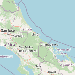
Map view of Irazú Volcano National Park

Use this park location map to pinpoint Irazú Volcano National Park in Costa Rica, understand its exact geographic position, and read its mapped placement within the surrounding landscape more clearly.

Pigeon | © OpenStreetMap contributors

Location context for Irazú Volcano National Park

Cartago Province
Natural feature types

Browse the Natural Features and Geological Landscapes of Irazú Volcano National Park

Examine the diverse physical geography associated with Irazú Volcano National Park by viewing our structured list of natural features. MoriAtlas provides a clear look at the volcanic terrain, crater lakes, and highland forest cover that characterize this vital protected area in Costa Rica.
Recorded earthquake history

Explore Historical Earthquake Records for Irazú Volcano National Park

Browse the historical seismic catalogue for Irazú Volcano National Park to review recorded events near this protected area. This MoriAtlas resource provides transparent access to event data, including magnitude and epicentre distance, to support a deeper understanding of regional geography.

Irazú Volcano National Park Earthquake History

Catalogued events

174 events

Strongest magnitude

Magnitude 6.5

Most recent event

Aug 1, 2026

This history includes earthquakes recorded inside the park or within 50 km of its borders

Park atlas

Browse nearby volcanic landscapes, highland forests, and diverse protected areas in central Costa Rica.

Explore Other National Parks and Protected Areas Near Irazú Volcano National Park

Discover additional national parks and protected areas near Irazú Volcano National Park, showcasing diverse volcanic landscapes, high-elevation forest ecosystems, and critical watershed protection zones. Compare these protected areas to understand regional ecological connections, trace distinct geological heritage, and broaden your atlas-based exploration of Costa Rica's conservation efforts.
National parkCosta Rica
6.1 km away#1 closest

Northeast

Turrialba Volcano National Park: Mapped Geography and Protected Landscape Context in Costa Rica

Explore the protected area's natural terrain and regional atlas placement

Turrialba Volcano National Park is a key protected landscape in Costa Rica, offering distinct geographic features and environmental context for atlas exploration. This page details the park's mapped boundaries and its significance as a national park, providing a foundation for understanding its place within the country's diverse natural terrain. Discover the unique geographic identity of this protected area and its role in the regional landscape.

Area
16 km²
Established
1955
IUCN
II
Relief
Mountain
National parkHeredia Province
7 km away#2 closest

Northwest

Braulio Carrillo National Park: Costa Rica's Protected Landscape in Heredia Province

National Park Boundaries and Regional Geography Exploration

Braulio Carrillo National Park represents a vital protected area, offering deep insights into its geographic setting within Heredia Province. This entry provides a focused view on the park's mapped boundaries and its identity as a national park, contributing essential data for regional geography and landscape atlas exploration. Understand the character of its protected terrain and its place within the broader mapped context.

Area
475.8 km²
Established
1978
IUCN
II
Relief
Mountain
National parkCosta Rica
22 km away#3 closest

South

Tapantí National Park: Costa Rica National Park Atlas and Mapped Landscape Exploration

Explore protected boundaries and natural terrain within its geographic setting.

Tapantí National Park is a designated national park in Costa Rica, offering specific insights into the country's protected natural landscapes. This page provides an atlas-style view of its geographic placement, the extent of its protected area, and the character of its natural terrain. Users can investigate the park's mapped context and understand its significance within the broader geography of Costa Rica, facilitating focused exploration of protected lands and regional landscape features.

Area
583.2 km²
Established
1982
IUCN
II
Relief
Mountain
National parkCosta Rica
34 km away#4 closest

South

Los Quetzales National Park: Costa Rica National Park Landscape and Mapped Geography

Explore protected area boundaries and regional terrain context.

Los Quetzales National Park, a designated national park within Costa Rica, offers a focused entry point for exploring protected landscapes. This page provides detailed insight into the park's geographic setting, emphasizing its mapped boundaries and its role within the national atlas. Users can discover the specific landscape characteristics and regional terrain that define Los Quetzales National Park, enriching their understanding of Costa Rican protected areas.

Area
50 km²
Established
2006
IUCN
II
Relief
Mountain
National parkAlajuela Province
40 km away#5 closest

Northwest

Poás Volcano National Park: National Park Protected Landscape in Alajuela Province

Mapped park boundaries and regional terrain context.

Poás Volcano National Park represents a vital protected landscape within Costa Rica's Alajuela Province. This detail page offers an atlas-centric view, emphasizing the park's geographic identity, its specific mapped boundaries, and its significance as a national park. Explore the natural terrain and understand the regional context of this protected area, ideal for geographic discovery and landscape exploration.

Area
65 km²
Established
1971
IUCN
II
Relief
Mountain
National parkLimón Province
About 45 km away#6 closest

East

Barbilla National Park: National Park Atlas Exploration and Geographic Context

Mapped protected landscape in Limón Province, Costa Rica

Barbilla National Park offers a focused view into Costa Rica's protected natural areas, specifically within the Limón Province. This entry provides an atlas-centric understanding of its geographic footprint and the character of its protected landscape. Explore the mapped boundaries and regional setting of this national park to enhance your structured geographic discovery.

Area
119 km²
Established
1982
IUCN
II
Relief
Mountain
National parkCartago Province
45 km away#7 closest

Southeast

Chirripó National Park: A Protected Landscape within Cartago Province's Geography

Explore its mapped boundaries and natural terrain.

This page provides detailed geographic context for Chirripó National Park, a designated national park located in the Cartago Province of Costa Rica. It focuses on the park's protected landscape identity, its position within the regional geography, and its distinct mapped boundaries. Understanding Chirripó National Park through its geographic and atlas-centric attributes offers a foundational insight into its natural significance.

Area
508.49 km²
Established
1975
IUCN
II
Climate
Alpine
National parkAlajuela Province
52 km away#8 closest

Northwest

Juan Castro Blanco National Park: National Park Boundaries and Alajuela Province Geography

Explore the protected landscape within north-central Costa Rica.

Juan Castro Blanco National Park offers a distinct protected landscape for geographic study within Alajuela Province. This national park serves as a key entity for exploring mapped boundaries, understanding local terrain, and situating its protected area within the broader atlas of Costa Rica. Delve into the specific geographic context and natural landscape features that define this important park.

Area
145 km²
Established
1992
IUCN
II
Relief
Mountain

Common questions about visiting, size, designation, and location context for Irazú Volcano National Park

Irazú Volcano National Park FAQs for park facts, access, geography, and protected area context

Find quick answers about Irazú Volcano National Park, including protected-area facts, park geography, trail and visitor context, and how the park fits into its surrounding country and regional landscape.
MoriAtlas Explorer

Continue Your Protected Areas Search Across the Global Atlas

Deepen your exploration by continuing the structured search for national parks and protected areas worldwide. Utilize the comprehensive filtering capabilities to compare different conservation landscapes and refine your understanding of global park geography. Discover more about the distribution and characteristics of protected natural areas.

Global natural geography