Mori Atlas logo
National parkTurrialba Volcano National Park

Discover the geographical identity and park context of Turrialba Volcano National Park

Turrialba Volcano National Park: Mapped Boundaries and Protected Landscape Geography in Costa Rica

(Parque Nacional Volcan Turrialba)

Turrialba Volcano National Park represents a significant protected landscape within the broader geography of Costa Rica. This entry provides an atlas-style view of its protected boundaries and natural terrain, offering insights into its regional context. As a national park, it serves as a focal point for understanding Costa Rica's conservation efforts and its unique environmental settings, inviting detailed geographic exploration.

Volcanic landscapesActive volcanoCentral AmericaNational parksMontane ecosystemsCosta Rica protected areas

Turrialba Volcano National Park

National park

Park overview

Structured park overview, official facts, and landscape profile for Turrialba Volcano National Park

Turrialba Volcano National Park park facts, protected area profile, and essential visitor context
Review the core facts for Turrialba Volcano National Park, including designation, size, terrain, visitor scale, habitats, and operating context in one park-focused overview.

About Turrialba Volcano National Park

Turrialba Volcano National Park occupies a significant position in Costa Rica's system of protected areas, centered on one of the nation's most geologically active volcanic peaks. The park is located within the Central Conservation Area in Cartago Province, approximately 50 kilometers east of the capital city of San José. The terrain is dominated by the massive form of Turrialba Volcano, a stratovolcano that rises to elevations around 3,340 meters above sea level. The park encompasses the volcano's upper slopes, crater areas, and the transitional zones where volcanic terrain meets the surrounding forested landscapes. Access to the park is primarily via Route 417, though visitor access to the immediate crater area remains restricted by a two-kilometer perimeter closure implemented due to ongoing volcanic activity. The park was closed to visitors between 2012 and 2020 due to eruptive events, reopening in December 2020 with enhanced safety measures including renovated visitor facilities and improved viewing infrastructure.

Quick facts and research context for Turrialba Volcano National Park

Turrialba Volcano National Park is located in Cartago Province, Costa Rica, about 50 kilometers east of San José. The park encompasses the area around Turrialba Volcano, an active stratovolcano rising to approximately 3,340 meters above sea level. Established in 1955, it covers roughly 3,900 acres within the Central Conservation Area. The park features a crater area accessible by hiking trails, with viewpoints offering panoramic vistas of the Caribbean plains and surrounding mountain ranges. Visitors can observe 84 bird species and 11 mammal species within the park's boundaries. The area has experienced significant volcanic activity, with major eruptions occurring between 1864 and 1868 and renewed activity beginning in 2014.

Park context

Deeper park guide and search-rich context for Turrialba Volcano National Park

Turrialba Volcano National Park history, landscape, wildlife, and travel context
Explore Turrialba Volcano National Park through its history, landscape character, ecosystems, wildlife, conservation priorities, cultural context, and seasonal travel timing in a structured park guide built for atlas discovery and search intent.

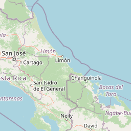
Why Turrialba Volcano National Park stands out

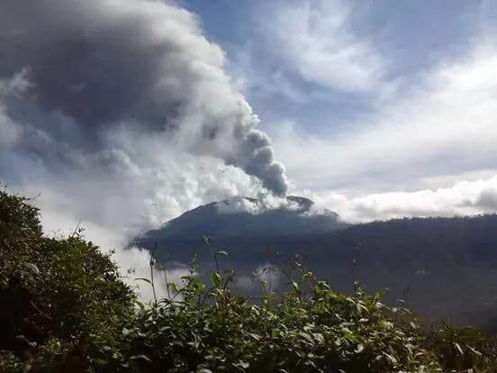
Turrialba Volcano National Park is best known for its active volcanic crater and the dramatic landscape shaped by ongoing volcanic processes. The park provides rare opportunities to observe an active Central American volcano up close, with its sulfurous vents, crater formations, and the distinctive barren terrain characteristic of recent volcanic activity. The panoramic views from the volcano's slopes are another defining feature, offering visitors sweeping vistas of the Caribbean plains extending to the east and the forested slopes of the Talamanca mountain range. The park's combination of volcanic scenery, biodiversity, and its status as one of Costa Rica's few accessible active volcanic zones makes it a distinctive destination within the country's protected area network.

Volcano erupting with smoke plume, green vegetation in foreground, cloudy sky
Turrialba Volcano erupting with a large smoke plume rising from the crater

Turrialba Volcano National Park history and protected-area timeline

Turrialba Volcano National Park was established on July 30, 1955, making it one of Costa Rica's older national parks. The creation of the park reflected growing recognition of the volcano's scientific, scenic, and conservation value. Major volcanic eruptions occurred between 1864 and 1868, events that predated the park's formal protection but demonstrated the mountain's significant eruptive potential. Beginning in 2014, Turrialba Volcano entered a period of renewed activity that included frequent ash emissions, explosive events, and the ejection of volcanic material. These eruptions produced ash clouds that affected portions of Costa Rica, depositing gritty volcanic ash and occasionally forcing the temporary closure of Juan Santamaría International Airport in San José. Due to safety concerns, the park was closed to visitors in 2012 and remained closed for nearly eight years. The park officially reopened on December 4, 2020, following a period of reduced activity and infrastructure improvements. During the closure period, emergency shelters were constructed, the visitor center was renovated, and safety railings were installed at key viewpoints.

Turrialba Volcano National Park landscape and geographic character

The landscape of Turrialba Volcano National Park is defined by the volcanic terrain of an active stratovolcano. The slopes of Turrialba rise steeply from the surrounding countryside, their profile shaped by centuries of volcanic building and periodic collapse. Near the summit, the terrain becomes increasingly barren and rugged, characteristic of areas affected by recent volcanic activity. The crater area features distinctive volcanic formations, active vents that emit sulfurous gases, and the gray, ashy terrain typical of active volcanic zones. From the higher vantage points within the park, visitors can observe the expansive Caribbean plains stretching eastward toward the coast, the Turrialba valley below, and the forested peaks of the Talamanca mountain range to the south and west. The contrast between the volcanic terrain's stark appearance and the surrounding green montane forests creates a visually striking landscape. The park encompasses both the rocky volcanic heights and the transitional zones where forest vegetation gradually recovers on older lava flows and ash deposits.

Turrialba Volcano National Park ecosystems, habitats, and plant life

The ecological character of Turrialba Volcano National Park reflects its position in the montane zone of central Costa Rica, where volcanic terrain meets diverse forest habitats. The park spans ecological transitions from the more barren volcanic summit areas through zones of shrub and pioneering vegetation to patches of forest on older volcanic deposits. The diverse habitats support notable biodiversity, with the park recording 84 bird species and 11 mammal species. The vegetation patterns include areas of secondary forest regrowth on older volcanic deposits, stands of montane forest in the more sheltered zones, and the distinctive low-growing vegetation adapted to the harsh conditions of recent volcanic substrates. The park lies within the Central Conservation Area, connecting to broader ecological corridors that facilitate wildlife movement through the mountainous terrain of central Costa Rica. The combination of volcanic disturbance dynamics and the relatively intact forest cover creates a mosaic of habitats that supports both specialized species adapted to volcanic environments and more common montane species.

Turrialba Volcano National Park wildlife and species highlights

The wildlife community within Turrialba Volcano National Park includes both resident species and seasonal visitors that utilize the diverse habitats found within the park's boundaries. Birdlife is particularly notable, with 84 species recorded including a variety of tropical songbirds, raptors, and forest-dwelling species. The montane forest habitats support bird species associated with cloud forest environments, while the more open volcanic areas provide foraging opportunities for species adapted to more open terrain. Mammal presence includes 11 species documented within the park, encompassing both smaller mammals and larger species that traverse the volcanic slopes and adjacent forested areas. The wildlife community reflects the park's position within the Central Conservation Area, a network of protected lands that maintains ecological connectivity across the mountainous terrain of central Costa Rica. The ongoing volcanic activity creates dynamic conditions that influence wildlife distribution and behavior within the park.

Turrialba Volcano National Park conservation status and protection priorities

Turrialba Volcano National Park is designated as an IUCN Category II protected area, reflecting its primary purpose of protecting natural ecosystems while allowing for controlled visitor use and interpretation. The park is managed by Costa Rica's National System of Conservation Areas, which coordinates the country's network of protected areas. The conservation significance of the park extends beyond its volcanic landscape to include the forest habitats that surround the volcanic core, habitats that contribute to the broader ecological integrity of the Central Conservation Area. The active volcanic nature of the site presents unique management challenges, balancing the goal of providing public access to this distinctive landscape with the need to protect visitors from volcanic hazards. The two-kilometer perimeter closure around the crater reflects a precautionary approach to visitor safety in an environment where eruptive events can occur with limited warning. The park's conservation value also includes its role in scientific monitoring of volcanic processes and ecosystem responses to volcanic disturbance.

Turrialba Volcano National Park cultural meaning and human context

The area surrounding Turrialba Volcano holds cultural significance for local communities in Cartago Province. The volcano has been a prominent feature in the regional landscape and local identity, visible from inhabited valleys and agricultural areas throughout central Costa Rica. Historical interactions between local communities and the volcanic landscape include both practical considerations related to volcanic hazards and the more intangible associations with the mountain's presence in the regional setting. The Turrialba area has a history of agricultural use, with coffee cultivation and other farming activities in the surrounding valleys. While the park itself is managed as a protected area, the broader cultural landscape includes the communities that have lived in the volcano's shadow and developed relationships with the land over generations. The park's name in Spanish, Parque Nacional Volcan Turrialba, reflects the local use of the geographic name.

Top sights and standout views in Turrialba Volcano National Park

The primary highlight of Turrialba Volcano National Park is the opportunity to visit an active volcanic crater within Costa Rica, one of the few places in Central America where visitors can experience an active stratovolcano at relatively close range. The panoramic viewpoints from the volcano's slopes offer sweeping vistas across central Costa Rica, encompassing the Caribbean plains, the Turrialba valley, and the Talamanca mountain range. Hiking trails traverse the volcanic terrain, allowing visitors to experience the distinctive landscape shaped by ongoing geological processes. The park's biodiversity, including 84 bird species, provides opportunities for wildlife observation, particularly for those interested in tropical birdlife. The recent history of volcanic activity adds an element of dynamism to the landscape, with the park's closure and subsequent reopening reflecting the ongoing relationship between volcanic processes and visitor access. The visitor center and viewing infrastructure were upgraded during the closure period, enhancing the interpretive experience.

Best time to visit Turrialba Volcano National Park

The optimal time to visit Turrialba Volcano National Park generally corresponds to the dry season in Costa Rica, typically running from December through April. During these months, precipitation is typically lower, and visitor access is more consistently available. The dry season also offers clearer atmospheric conditions for viewing the panorama from the volcano's slopes, though cloud cover can develop quickly in the mountain environment regardless of season. Visitors should be aware that volcanic activity is inherently unpredictable, and the park's status can change with little advance notice depending on current conditions. Checking current park status and volcanic activity reports before planning a visit is advisable. The park's operational hours and access policies reflect the need to manage visitor safety in an active volcanic environment, with tours typically running from early morning through mid-morning.

Park location guide

Geography guide, regional context, and park location map for Turrialba Volcano National Park

Turrialba Volcano National Park park geography, regions, and map view in Costa Rica
Understand where Turrialba Volcano National Park sits in Costa Rica through a broader geographic reading of the surrounding landscape, nearby location context, and its mapped position within the national park landscape.

How Turrialba Volcano National Park fits into Costa Rica

Costa Rica is a Central American country with coastlines on both the Caribbean Sea and Pacific Ocean. It gained independence from Spain in 1821 and operates as a unitary presidential republic with no standing military. The economy has diversified from agriculture into finance, pharmaceuticals, and ecotourism.

Wider geography shaping Turrialba Volcano National Park in Costa Rica

Costa Rica is located in Central America, bordered by Nicaragua to the north, the Caribbean Sea to the northeast, Panama to the southeast, and the Pacific Ocean to the southwest. It shares a maritime boundary with Ecuador. The terrain includes coastal plains, mountain ranges, and volcanic landscapes.

Map view of Turrialba Volcano National Park

Use this park location map to pinpoint Turrialba Volcano National Park in Costa Rica, understand its exact geographic position, and read its mapped placement within the surrounding landscape more clearly.

Pigeon | © OpenStreetMap contributors

Location context for Turrialba Volcano National Park

Cartago Province

Visually discover the dramatic terrain, distinct volcanic features, and diverse montane ecosystems within this Costa Rican protected area.

Turrialba Volcano National Park Photos: Explore Active Volcanic Landscapes and Pristine Nature
Browse a comprehensive gallery of images from Turrialba Volcano National Park to gain a visual understanding of its active volcanic landscape, unique crater formations, and surrounding montane forests. These photographs provide essential context for tracing the park's distinct geological character and observing the diverse habitats that define this significant Central American protected area.

Volcano erupting with smoke plume, green vegetation in foreground, cloudy sky

Waterfall flowing into a river with lush green vegetation on rocky cliffs

Park atlas

Trace Costa Rica's protected landscapes and volcanic terrain near Turrialba Volcano National Park

Explore Nearby National Parks and Protected Areas around Turrialba Volcano National Park, Costa Rica
After exploring Turrialba Volcano National Park, continue your discovery of Costa Rica's active volcanic peaks and diverse montane protected areas throughout the Central Conservation Area. Compare neighboring national parks and conservation zones to understand the broader regional geography and trace the spread of protected volcanic and forest landscapes.
National parkCartago Province

Irazú Volcano National Park: National Park Protected Area Atlas

Mapped Boundaries and Volcanic Terrain

Irazú Volcano National Park stands as a distinct protected area within the landscape of Cartago Province, Costa Rica. This page provides an atlas-centric view, detailing the park's mapped boundaries and its identity as a national park. Explore the volcanic geography and regional context, understanding its contribution to the protected lands of Central America.

Area
20 km²
Established
1955
IUCN
II
Relief
Mountain
National parkHeredia Province

Braulio Carrillo National Park: Costa Rica's Protected Landscape in Heredia Province

National Park Boundaries and Regional Geography Exploration

Braulio Carrillo National Park represents a vital protected area, offering deep insights into its geographic setting within Heredia Province. This entry provides a focused view on the park's mapped boundaries and its identity as a national park, contributing essential data for regional geography and landscape atlas exploration. Understand the character of its protected terrain and its place within the broader mapped context.

Area
475.8 km²
Established
1978
IUCN
II
Relief
Mountain
National parkCosta Rica

Tapantí National Park: Costa Rica National Park Atlas and Mapped Landscape Exploration

Explore protected boundaries and natural terrain within its geographic setting.

Tapantí National Park is a designated national park in Costa Rica, offering specific insights into the country's protected natural landscapes. This page provides an atlas-style view of its geographic placement, the extent of its protected area, and the character of its natural terrain. Users can investigate the park's mapped context and understand its significance within the broader geography of Costa Rica, facilitating focused exploration of protected lands and regional landscape features.

Area
583.2 km²
Established
1982
IUCN
II
Relief
Mountain
National parkLimón Province

Barbilla National Park: National Park Atlas Exploration and Geographic Context

Mapped protected landscape in Limón Province, Costa Rica

Barbilla National Park offers a focused view into Costa Rica's protected natural areas, specifically within the Limón Province. This entry provides an atlas-centric understanding of its geographic footprint and the character of its protected landscape. Explore the mapped boundaries and regional setting of this national park to enhance your structured geographic discovery.

Area
119 km²
Established
1982
IUCN
II
Relief
Mountain
National parkCosta Rica

Los Quetzales National Park: Costa Rica National Park Landscape and Mapped Geography

Explore protected area boundaries and regional terrain context.

Los Quetzales National Park, a designated national park within Costa Rica, offers a focused entry point for exploring protected landscapes. This page provides detailed insight into the park's geographic setting, emphasizing its mapped boundaries and its role within the national atlas. Users can discover the specific landscape characteristics and regional terrain that define Los Quetzales National Park, enriching their understanding of Costa Rican protected areas.

Area
50 km²
Established
2006
IUCN
II
Relief
Mountain
National parkAlajuela Province

Poás Volcano National Park: National Park Protected Landscape in Alajuela Province

Mapped park boundaries and regional terrain context.

Poás Volcano National Park represents a vital protected landscape within Costa Rica's Alajuela Province. This detail page offers an atlas-centric view, emphasizing the park's geographic identity, its specific mapped boundaries, and its significance as a national park. Explore the natural terrain and understand the regional context of this protected area, ideal for geographic discovery and landscape exploration.

Area
65 km²
Established
1971
IUCN
II
Relief
Mountain
National parkLimón Province

Tortuguero National Park: Protected Landscape and Regional Geographic Context

National Park mapped in Limón Province, Costa Rica.

Delve into Tortuguero National Park, a significant national park situated in Limón Province, Costa Rica. This entry offers detailed insights into its protected area status, mapped geographic extent, and its role within the regional natural landscape context. Ideal for users seeking a structured atlas view of protected lands and their geographical distribution, providing foundational data for understanding this specific conservation landscape.

Area
312 km²
Established
1975
IUCN
II
Visitors
10K annual
National parkCartago Province

Chirripó National Park: A Protected Landscape within Cartago Province's Geography

Explore its mapped boundaries and natural terrain.

This page provides detailed geographic context for Chirripó National Park, a designated national park located in the Cartago Province of Costa Rica. It focuses on the park's protected landscape identity, its position within the regional geography, and its distinct mapped boundaries. Understanding Chirripó National Park through its geographic and atlas-centric attributes offers a foundational insight into its natural significance.

Area
508.49 km²
Established
1975
IUCN
II
Climate
Alpine

Common questions about visiting, size, designation, and location context for Turrialba Volcano National Park

Turrialba Volcano National Park FAQs for park facts, access, geography, and protected area context
Find quick answers about Turrialba Volcano National Park, including protected-area facts, park geography, trail and visitor context, and how the park fits into its surrounding country and regional landscape.
MoriAtlas Explorer

Continue Your Protected Areas Search Across the Global Atlas

Deepen your exploration by continuing the structured search for national parks and protected areas worldwide. Utilize the comprehensive filtering capabilities to compare different conservation landscapes and refine your understanding of global park geography. Discover more about the distribution and characteristics of protected natural areas.

Global natural geography