

Mori Atlas logo
Wildlife reserveKarakamia Sanctuary

A predator-free refuge for native mammal recovery within the jarrah forests of Western Australia.

Karakamia Sanctuary Wildlife Reserve: Mapping the Geography and Protected Landscapes of the Darling Scarp

Karakamia Sanctuary functions as a vital protected wildlife reserve within the Darling Scarp of south-west Western Australia. Spanning a lateritic plateau, this 2.75 square kilometre site preserves a complex mix of jarrah, marri, and wandoo woodlands alongside riparian stream corridors. It serves as a cornerstone for native mammal reintroduction and serves as the founding property for the Australian Wildlife Conservancy.

nature reservejarrah forestDarling ScarpMediterranean climatewildlife reintroductionpredator-free sanctuary

Karakamia Sanctuary

Wildlife reserve

Park overview

Structured park overview, official facts, and landscape profile for Karakamia Sanctuary

Karakamia Sanctuary park facts, protected area profile, and essential visitor context

Review the core facts for Karakamia Sanctuary, including designation, size, terrain, visitor scale, habitats, and operating context in one park-focused overview.

About Karakamia Sanctuary

Karakamia Sanctuary is a compact but ecologically significant nature reserve in the Darling Scarp of south-west Western Australia. Occupying roughly 2.75 square kilometres of jarrah-dominated forest near Chidlow, it sits within the broader south-west Australian woodland and forest belt, an area of high biodiversity and endemism, while remaining close enough to Perth to play an outreach as well as conservation role.

The reserve is owned and managed by the Australian Wildlife Conservancy, and has a clear identity as a working conservation site rather than a purely scenic park. Its core purpose is to provide a secure refuge, free from introduced predators and hard-hoofed herbivores, in which populations of threatened and locally extinct native mammals can be re-established and monitored. A vermin-proof fence surrounds the property, allowing the sanctuary to function as an effectively predator-free environment.

Geographically, Karakamia is defined by the lateritic plateau of the Darling Scarp and the dense jarrah forests that characterise the region. Its mix of jarrah, marri, wandoo, and blackbutt woodland, interspersed with heathland and shrubland and crossed by winter-flowing streams, gives the sanctuary a varied habitat mosaic despite its modest size. Replanting programs continue on parts of the property that were historically cleared or selectively logged, gradually extending the continuity of native vegetation.

As a conservation site, Karakamia is notable both for its fauna recovery work and for its place in the history of the Australian Wildlife Conservancy. It is closely associated with conservationist Martin Copley, who originally purchased the property in 1991 and established it as a sanctuary in 1992, marking the beginning of what would grow into a national network of private reserves. Today, Karakamia remains an important showcase of how targeted management and predator control can support the recovery of species that have been pushed close to local extinction elsewhere in the region.

Quick facts and research context for Karakamia Sanctuary

Karakamia Sanctuary is a privately owned nature reserve of about 2.75 square kilometres in the Darling Scarp, south-west Western Australia, located a few kilometres from Chidlow and within roughly 50 kilometres of Perth. It was acquired in 1991 by conservationist Martin Copley, established as a sanctuary in 1992, and now forms part of the Australian Wildlife Conservancy's reserve network.

The sanctuary lies within the jarrah forest belt and sits on a lateritic plateau with winter-flowing streams. Its Mediterranean climate receives about 850 millimetres of rainfall annually, concentrated in the winter months, with dry summers typical of the region. More than 260 plant species have been recorded across its forest, woodland, heathland, and stream-side communities.

Protection and recognition

Explore the documented terrestrial conservation scope and recognition history.

Karakamia Sanctuary Protection Status and International Recognition Data

Karakamia Sanctuary maintains a documented terrestrial protection scope within its designated natural boundary. Structured conservation records outline the official management framework and international recognition status associated with the protected landscape.

Protection details

Protection scope
Terrestrial
Transboundary protection
No
Park context

Deeper park guide and search-rich context for Karakamia Sanctuary

Karakamia Sanctuary history, landscape, wildlife, and travel context

Explore Karakamia Sanctuary through its history, landscape character, ecosystems, wildlife, conservation priorities, cultural context, and seasonal travel timing in a structured park guide built for atlas discovery and search intent.

Why Karakamia Sanctuary stands out

Karakamia is best known as a predator-free sanctuary for the reintroduction and protection of native mammals that have disappeared from much of the surrounding south-west Australian landscape. Species such as the numbat, woylie, quenda, tammar wallaby, quokka, and western ringtail possum have been re-established on the property, making it a key site for fauna recovery within the Darling Scarp. The sanctuary is also strongly associated with the early development of the Australian Wildlife Conservancy, with Karakamia acting as the founding property of what has become one of Australia's largest private conservation organisations. Its combination of jarrah forest, lateritic plateau, perennial streams, and heathland communities adds a distinctive habitat dimension to its conservation role, while the red-tailed black-cockatoo's forest subspecies gives the site particular significance for bird conservation.

Karakamia Sanctuary history and protected-area timeline

Karakamia's history as a conservation site began in 1991, when it was purchased by Australian conservationist Martin Copley. The following year, in 1992, it was formally established as a sanctuary, providing the foundation for what would become the Australian Wildlife Conservancy. Karakamia is therefore recognised as the organisation's founding property and the seed from which its broader network of reserves developed.

Since the initial purchase, the sanctuary has expanded gradually through the acquisition of adjacent private land. Although much of the property was never cleared, some sections had been affected by historical clearing or selective logging. A replanting program has been implemented to restore these areas, extending the continuity of native vegetation and improving habitat value across the reserve.

The conservation approach at Karakamia evolved to include the construction of a vermin-proof fence around the property, allowing the sanctuary to be managed as a predator-free and herbivore-free environment. This infrastructure made it possible to reintroduce native mammal species that had disappeared from the surrounding landscape, cementing the sanctuary's reputation as a key site for fauna recovery in south-west Western Australia.

Karakamia Sanctuary landscape and geographic character

Karakamia sits on a lateritic plateau within the Darling Scarp, an elevated landscape feature that runs roughly parallel to the Western Australian coast and forms a major ecological boundary between the inland plains and the forested ranges closer to the coast. The plateau supports dense jarrah forest and gives the sanctuary a characteristically undulating terrain shaped by long-term weathering of the underlying laterite.

Winter-flowing streams cross the property, fed by the region's Mediterranean rainfall pattern. These watercourses create distinct micro-habitats along their banks, supporting different vegetation from the surrounding plateau. Around the streams, a community of flooded gum and sedges has developed, contrasting with the drier woodland and heathland communities on higher ground.

The combination of lateritic uplands, deep jarrah forest, and riparian stream corridors gives Karakamia a compact but diverse physical setting. While the sanctuary is small in area, the variation within its 2.75 square kilometres reflects the broader landscape complexity of the Darling Scarp, where geology, soils, and rainfall interact to produce a patchwork of habitats.

Karakamia Sanctuary ecosystems, habitats, and plant life

The vegetation of Karakamia reflects the broader ecological richness of the Darling Scarp and the south-west Australian forests, a region recognised as one of the world's biodiversity hotspots. More than 260 plant species have been recorded on the property, distributed across a mosaic of forest, woodland, heathland, and riparian communities.

Jarrah forest forms the dominant vegetation type and gives the sanctuary its overall character, but Karakamia also contains substantial areas of marri, wandoo, and blackbutt woodland. These eucalypt-dominated communities vary in structure and composition, producing differing understorey conditions and supporting different fauna. Pockets of heathland and shrubland contribute additional floral diversity, while the winter-flowing streams support a distinct community of flooded gum and sedges, providing wetter habitat along the watercourses.

Together, these vegetation types create a layered habitat mosaic that supports a wide range of native fauna. The contrast between the dry upland forests and the moist stream-side communities is particularly important for the sanctuary's ecological function, allowing species with different habitat requirements to coexist within a small area.

Karakamia Sanctuary wildlife and species highlights

Karakamia's wildlife profile is shaped above all by its role as a predator-free sanctuary for the reintroduction of native mammals. A vermin-proof fence now surrounds the property, excluding introduced predators and hard-hoofed herbivores, and creating conditions in which vulnerable native species can rebuild populations.

Several mammals that would once have occurred across the Darling Scarp have been successfully reintroduced at Karakamia. These include the woylie, or brush-tailed bettong, a small macropod once widespread across southern Australia; the quenda, a south-western brown bandicoot; the tammar wallaby, a wallaby species closely associated with south-western habitats; the quokka, a small macropod famous from other parts of Western Australia; the numbat, a termite-eating marsupial notable for its distinctive appearance and conservation significance; and the western ringtail possum, a possum species under serious pressure elsewhere in its range.

Birdlife is also an important component of the sanctuary's fauna, with the forest subspecies of the red-tailed black-cockatoo being a particularly significant species present on the property. The cockatoo's dependence on specific eucalypt species for breeding and feeding gives Karakamia additional conservation value as a habitat for this forest-dependent bird, alongside the mammal reintroduction program that defines the reserve's identity.

Karakamia Sanctuary conservation status and protection priorities

Karakamia's principal conservation value lies in its role as a secure refuge for threatened and locally extinct native mammals in a landscape where introduced predators, habitat loss, and historical land use have substantially reduced native fauna populations. By maintaining a predator-free environment through vermin-proof fencing, the sanctuary provides conditions under which species that have declined across the broader Darling Scarp can be kept and bred.

The reintroduction of mammals such as the numbat, woylie, quenda, tammar wallaby, quokka, and western ringtail possum reflects a deliberate strategy to restore the native mammal community of the area. This work has given Karakamia an important role within the conservation programs of the Australian Wildlife Conservancy, particularly as one of the organisation's original and flagship sites.

Beyond fauna management, the sanctuary contributes to conservation through habitat restoration. Replanting of areas that were historically cleared or selectively logged aims to rebuild continuous native vegetation, strengthening the ecological resilience of the reserve. The combination of predator exclusion, habitat restoration, and careful vegetation management makes Karakamia a working example of how relatively small reserves can play an outsized role in regional biodiversity recovery.

Top sights and standout views in Karakamia Sanctuary

The standout features of Karakamia include its jarrah-forest setting on a lateritic plateau, its more than 260 recorded plant species spread across woodland, heathland, and riparian communities, and its role as a predator-free sanctuary for the reintroduction of native mammals. The presence of the forest subspecies of the red-tailed black-cockatoo adds notable bird conservation significance to the property.

Karakamia also stands out for its place in the history of the Australian Wildlife Conservancy. As the organisation's founding property, originally acquired in 1991 and established as a sanctuary in 1992, it represents the starting point of one of Australia's largest private conservation efforts. Its combination of founding status, active fauna recovery, and habitat restoration gives the sanctuary a distinct identity within the broader network of south-west Australian reserves.

Best time to visit Karakamia Sanctuary

Karakamia sits within a Mediterranean climate zone, with wet winters and dry summers, so the practical character of a visit shifts considerably with the seasons. Winter and spring are typically the greenest and most floristically active periods, with rainfall replenishing streams and a wide range of wildflowers and understorey plants in bloom. Cooler temperatures also make walking through the jarrah forest more comfortable.

Summer brings warm to hot, dry conditions typical of south-west Western Australia. While the landscape turns drier and vegetation becomes less lush, this is also a quieter period for many native animals, and early mornings and late afternoons may offer more active wildlife viewing. Visitors should generally align any outing with weather conditions, as winter rainfall can make tracks and stream crossings more difficult, while summer heat requires planning around cooler parts of the day.
Monthly climate preview

Long-term monthly temperature and precipitation rhythm across the Western Australia reserve coordinate

Karakamia Sanctuary Climate Normals and Annual Temperature Patterns

Karakamia Sanctuary displays a measured long-term annual rhythm defined by high summer temperatures and distinct winter precipitation cycles recorded across representative regional coordinates. Reviewing the complete twelve-month statistical profile clarifies month-by-month temperature ranges and precipitation averages without relying on short-term forecasts.
Annual mean18 °C
11 °C25 °C
Jan25°
Feb25°
Mar23°
Apr19°
May15°
Jun12°
Jul11°
Aug11°
Sep12°
Oct16°
Nov20°
Dec23°
Warmest month
January

25.3 °C

Coolest month
July

10.9 °C

Wettest month
July

3.9 mm/day

Driest month
December

0.4 mm/day

Park location guide

Geography guide, regional context, and park location map for Karakamia Sanctuary

Karakamia Sanctuary park geography, regions, and map view in Australia

Understand where Karakamia Sanctuary sits in Australia through a broader geographic reading of the surrounding landscape, nearby location context, and its mapped position within the national park landscape.

How Karakamia Sanctuary fits into Australia

Australia is a constitutional monarchy and federal parliamentary democracy comprising six states and ten territories. With a population of nearly 28 million, it is one of the world's most urbanised countries, with most people concentrated on the eastern seaboard. The country has a high Human Development Index and is known for its cultural diversity, ancient Aboriginal heritage, and unique wildlife.

Wider geography shaping Karakamia Sanctuary in Australia

Australia occupies the entire Australian continent, the island of Tasmania, and numerous smaller islands. It is the world's flattest and driest inhabited continent, featuring vast deserts in the interior (the Outback), tropical rainforests along the eastern coast, and a coastline bordering the Indian and Pacific Oceans.

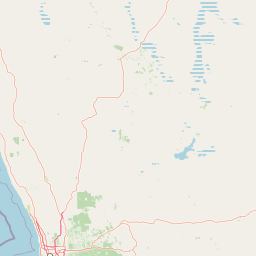
Map view of Karakamia Sanctuary

Use this park location map to pinpoint Karakamia Sanctuary in Australia, understand its exact geographic position, and read its mapped placement within the surrounding landscape more clearly.

Pigeon | © OpenStreetMap contributors

Location context for Karakamia Sanctuary

Western Australia
Park atlas

Compare regional reserves and connected habitats across the Darling Scarp.

Exploring Parks Near Karakamia Sanctuary and Surrounding Protected Landscapes

Browse protected areas and natural reserves located near Karakamia Sanctuary in south-west Western Australia. Comparing these regional habitats reveals broader conservation patterns across the surrounding jarrah forest terrain.
National parkWestern Australia
About 9.9 km away#1 closest

Southwest

Beelu National Park: Exploring Western Australia's Protected Jarrah-Marri Forest Landscape

Mapped Geographic Context & Natural Terrain Discovery

Beelu National Park, situated in Western Australia's Darling Range, offers an immersive experience within old-growth jarrah-marri forests. This protected area provides a vital glimpse into the region's natural landscapes, characterized by rolling hills and the Helena River valley. Users can explore the park's geographic setting, its mapped boundaries, and the unique ecological context it preserves. It stands as a significant natural reserve contributing to the understanding of Western Australia's conservation efforts and diverse terrain.

Area
46.17 km²
Established
1995
IUCN
II
Relief
Highland
National parkWestern Australia
About 13 km away#2 closest

West

John Forrest National Park: National Park Atlas and Western Australia Protected Landscape

Mapped boundaries and regional geographic context.

Delve into the atlas-level details of John Forrest National Park, a protected area situated in Western Australia. This park's designation as a national park provides a focal point for understanding its specific geographic features and mapped extent. Users can explore its place within the broader regional geography of Western Australia, gaining structured insight into the protected landscape.

Area
26.78 km²
Established
1900
IUCN
II
Relief
Upland
National parkWestern Australia
About 14 km away#3 closest

Northwest

Walyunga National Park: National Park Discovery in Western Australia's Geographic Landscape

Mapped boundaries and regional protected area context.

Walyunga National Park serves as a key protected area within the expansive geography of Western Australia. This detailed view focuses on its identity as a national park, offering insights into its mapped landscape and its specific role within the state's conservation network. Users can explore its protected boundaries and understand its place in the regional geography, contributing to a structured atlas of natural areas.

Area
18.14 km²
Established
1970
IUCN
II
Relief
Mixed relief
National parkWestern Australia
About 15 km away#4 closest

South

Helena National Park: National Park with Regional Geographic Context in Western Australia

Mapping protected area boundaries and natural landscapes.

Helena National Park represents a significant protected area within the expansive geography of Western Australia. This page facilitates detailed exploration of its national park status, offering insights into its mapped boundaries and the regional landscape context. Discover how Helena National Park contributes to the protected land atlas of Western Australia, providing a specific focus for geographic understanding and park exploration.

Area
122.55 km²
Established
2004
Relief
Upland
Climate
Mediterranean
National parkWheatbelt
About 18 km away#5 closest

Southeast

Wandoo National Park National Park: Explore Protected Landscape and Geographic Boundaries

Discover Wheatbelt's mapped protected area.

Wandoo National Park is a designated national park situated in Australia's Wheatbelt region, offering a focal point for understanding protected landscapes. This page provides detailed geographic context for the park, highlighting its mapped boundaries and its significance within the broader regional geography. Users can explore the park's protected area status and its contribution to the mapped natural landscape of Western Australia, serving as a key entry point for atlas-based discovery.

Area
463.68 km²
Established
2004
IUCN
II
Climate
Temperate
National parkWestern Australia
About 18 km away#6 closest

Southwest

Greenmount National Park: Western Australia National Park Landscape and Geography Atlas

Explore its protected boundaries and regional landscape context.

Greenmount National Park represents a distinct protected landscape within the diverse geography of Western Australia. As a National Park, its mapped boundaries are integral to understanding its regional context and offering users a point of detailed geographic discovery. This entry provides essential data on its protected status and geographic setting, supporting exploration of Australia's significant natural areas through an atlas-driven lens.

Area
2.02 km²
Established
1970
IUCN
II
Relief
Upland
National parkWestern Australia
About 19 km away#7 closest

North

Avon Valley National Park: Protected National Park Discovery in Western Australia

Explore mapped boundaries and regional landscape context.

Delve into Avon Valley National Park, a designated national park offering rich opportunities for protected-area and landscape discovery. This page serves as an atlas-style entry point, detailing the park's mapped geography and its role within the diverse natural terrain of Western Australia. Understand its specific protected landscape identity and how it contributes to the broader conservation map.

Area
43.66 km²
Established
1970
IUCN
II
Relief
Mixed relief
Watercolor illustration of a landscape with rolling hills, trees, and fields
National parkWestern Australia
About 21 km away#8 closest

Southwest

Kalamunda National Park: Explore Darling Scarp Woodland & Western Australia's Natural Terrain

A protected national park with distinct mapped landscape features.

Kalamunda National Park is an essential protected area located on the western slopes of the Darling Scarp, offering a clear representation of southwestern Australia's characteristic eucalypt woodland ecosystems. Its geography is defined by the escarpment's terrain, supporting tall marri, jarrah, and wandoo forests with a diverse understorey. As a national park, it provides critical habitat and contributes to the regional landscape context within Western Australia, making it a valuable point for atlas-driven discovery of protected natural areas.

Area
3.75 km²
Established
1964
IUCN
II
Relief
Mixed relief

Common questions about visiting, size, designation, and location context for Karakamia Sanctuary

Karakamia Sanctuary FAQs for park facts, access, geography, and protected area context

Find quick answers about Karakamia Sanctuary, including protected-area facts, park geography, trail and visitor context, and how the park fits into its surrounding country and regional landscape.
MoriAtlas Explorer

Continue Your Protected Areas Search Across the Global Atlas

Deepen your exploration by continuing the structured search for national parks and protected areas worldwide. Utilize the comprehensive filtering capabilities to compare different conservation landscapes and refine your understanding of global park geography. Discover more about the distribution and characteristics of protected natural areas.

Global natural geography